• We have updated our Community Code of Conduct. Please read through the new rules for the forum that are an integral part of Paradox Interactive’s User Agreement.

Tinto Maps #25 - 8th of November 2024 - South East Asia

Hello, and welcome to another week of fun unveiling of the map of Project Casar. In this week’s Tinto Maps we will be taking a look at South East Asia, so without further ado let’s get started.

Countries
Countries.png
Colored wastelands.png

Quite a variety of countries in the area. The regional power in the decades before 1337 was the Khmer Empire, although at this point they are already in decline and have lost much of their previous hegemony. On the west, the fall of the Burmese Pagan Kingdom and the following Mongol invasions gave rise to the disunited kingdoms of Pinya, Sagaing, Prome, and Toungoo, while in the south the Mon kingdom of Hanthawaddy (also known as Pegu) also split apart. On the center, the decline of the old Lavo Kingdom and its subjugation to the Khmer gave way to the emergence of the Kingdom of Sukhothai when Khmer started its decline too, and Sukhothai is emerging as the dominant Thai kingdom in the area. However, Ayodhya is already gestating the rise of another great kingdom, as King Ramathibodi, the founder of the Ayutthaya Kingdom is already poised to gain power in the region. On the east coast, the Kingdom of Đại Việt is under the orbit of the Yuán, with constant conflict with the southern Hindu kingdom of Champa.

Societies of Pops
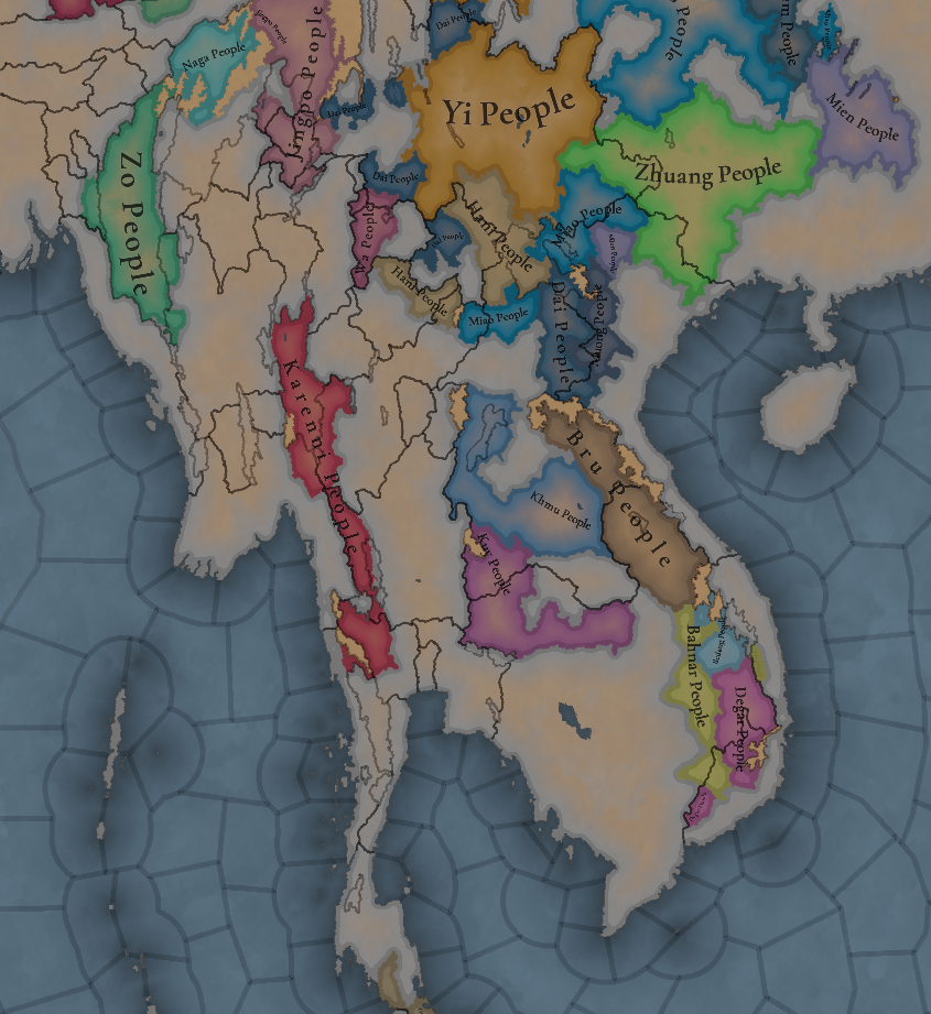
SoP.png

A region very rich in Societies of Pops, which will make it definitely an interesting area.

Dynasties
Dynasties.png

The dynasty of the old Pagan Empire is still alive in Prome, with many other dynasties in the region having ties with it, while the different Thai dynasties also have ties among each other.

Locations
Locations.png

Locations zoom 1.png

Locations zoom 2.png

Locations zoom 3.png

Provinces
Provinces.png

Provinces zoom 1.png

Provinces zoom 2.png

Areas
Areas.png

Unfortunately, currently the name of the sea area encroaches too much into the land (this will be fixed, don’t worry), but the blue area that gets underneath that name is Chao Phraya.

Terrain
Topography.png

Vegetation.png

Climate.png

Tropical and jungle almost everywhere, with quite a bit of comparison between the southern flatlands and the northern mountainous areas.

Development
Development.png

Not as developed as the surrounding India or China, but the main centers of power (like Angkor, Pagan, and Sukhothai) are a bit more developed.

Natural Harbors
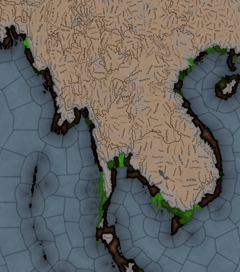
Natural Harbors.png


Cultures
Cultures.png

A quite variety of cultures, although the southern areas haven’t had their minorities done yet so there will be even more variation there.

Languages
Languages.png

As an addition from this week one, we have a new map to show with the languages. Keep in mind that this area hasn't had any language families or dialects done yet, so there is a bit of grouping.

Religions
Religion.png

Again, keep in mind that minorities are not done, so there will be more variation added inside the Theravada block, as there has to be still quite a bit of Hinduism presence in Khmer (its conversion from Hinduism to Buddhism at that point was one of the causes of its decline), and quite a bit more of Satsana Phi among all the Tai peoples.

Raw Materials
Raw Resources.png

Raw Resources zoom 1.png
Raw Resources zoom 2.png
Raw Resources zoom 3.png
Quite a variation of resources, although dominated mainly by lumber and rice.

Markets
Markets.png

The commerce is dominated by those countries benefiting from sea trade routes, but the emergence of a strong Ayutthaya Kingdom in the middle will for sure cause a change in the balance of powers.

Population
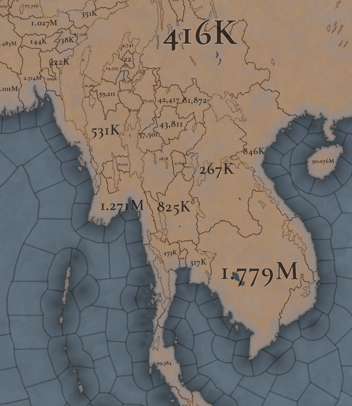
Population.png

Population zoom 1.png
Population zoom 2.png
Population zoom 3.png
Population zoom 4.png
Khmer is still the most populated, but other countries around don’t fall that far behind, especially when they manage to unify their areas a bit. There’s also a couple of locations appearing as 0 population that is definitely a bug that will have to be fixed.

That is all for this week. Join us next week when we set sail to take a look at the maritime part of South East Asia by taking a look at all the archipelago of Indonesia (including the Philippines). Hope to see you there.
 
  • 117Like
  • 39Love
  • 3
  • 1
  • 1
Reactions:
I know people have complained already but I'm adding mine to the pile:

Vegetation.png


This map fails at its job. When I see such kind of map, I expect 1 (one, uno, ein, ichi) color inside each delimited area. Not only you have a gradient, the central color reminds me of another type of terrain (desert). Which implies the borders are more forested/"junglier" than the center. Which is dumb and not at all what this map means to convey (it's a vegetation type map, not vegetation density map).

So I think you guys should drop this idea altogether. Not only does it not work, it works against the mapmode's function.
 
  • 9Like
  • 6
  • 2
Reactions:
Not sure if anyone's addressed this yet and I don't feel like going through every reply, but Miao is an exonym and for a lot of this period a pejorative one. It also doesn't map precisely to a single identity, though here it seems to be labeling Hmong peoples. I would suggest renaming the culture to Hmong.
 
  • 2
  • 1Like
  • 1
Reactions:
Raw materials in Burma
(Gazetteer of Upper Burma and the Shan States, Part I. Vol.II)


Wheat
This was the first thing I spotted, there should probably be a lot less wheat locations, it seems like it was never an important crop until the 1900s. Another note is that the Shan people were primarily wet-rice cultivators, and the hill tribes around them grew sturdy grains or beans.
Screenshot_20241109-151507.png


Cotton
Raw cotton was grown in large quantities around Myingyan (Talok in-game) and Meiktila (Pindale or Nyaungyan).
Screenshot_20241113-112616.png


Silk
There were large silk-weaving industries in Sagaing and Amarapura (Pinya), but raw silk mostly seems to have been harvested further south.
Screenshot_20241109-152428~2.png

Screenshot_20241113-112448~2.png


Salt
There were lots of salt wells around Shwebo (Moksobo). There was also 1 salt well in Hsipaw, but it wasn't used consistently.
Screenshot_20241110-222108~2.png


Stone/Clay
There was an important alabaster mine in Sagyin (Ngasingu), I'm not sure if that would count more as clay or stone.
Screenshot_20241110-222921~2.png


Gold
Gold should be moved from Takawng to Wuntho.
Screenshot_20241110-222711.png


Amber
Zalon Taung shouldn't have any amber, the only old amber mine was in Maingkwan in the Hukawng valley. I read somewhere that there was an old gem mine in Maing Kaing (in current Zalon Taung location), but I can't find it.

Horses
Apparently cavalry were used a lot by Shan armies, and they were used mostly as cavalry in later Burmese armies, it seems like there might have been more horse rearing in some areas of north Burma and the Shan hills in the past, around Hsenwi, Hsipaw, and possibly Mong Yang.
Screenshot_20241217-111820~2.png

Screenshot_20241111-110100~2.png
 
Last edited:
  • 5
  • 1Like
Reactions:
Does anyone have any information about the Laotian principality in the city of Vientiane?


gf.png

Victorious over his grandfather, Fa-Ngum acceded to the throne of present-day Luang Prabang in 1353. It was then that he gave his kingdom the name of Lan Xang . He imposed his suzerainty on the kingdom of Vientiane and the principalities of Sip-Song-Pha-Na and Lan-Na .
Colored wastelands.png

Cobra/Tóushé Kingdom
 
Last edited:
  • 6Like
  • 6
Reactions:
if we are gonna use historical data, what makes ottomans green instead of red? Yes they used green often but they used red alot more.

if we need historical data for this then this needs to apply to every single country.
Tbf I don't think the Paradox community is ready for the 'Castile should be red and not yellow' thread.
 
  • 3Like
Reactions:
Does anyone have any information about the Laotian principality in the city of Vientiane?


View attachment 1215872
Victorious over his grandfather, Fa-Ngum acceded to the throne of present-day Luang Prabang in 1353. It was then that he gave his kingdom the name of Lan Xang . He imposed his suzerainty on the kingdom of Vientiane and the principalities of Sip-Song-Pha-Na and Lan-Na .
View attachment 1215893
Cobra/Tóushé Kingdom

Screenshot_20241113-192653.png

I couldn't find much information, other than it existed in 1337.

Laos seems to have been ruled by a number of semi-independent city states (Muangs), where Muang Sua and Vieng Chan were the strongest (and therefore held power over the other Muangs). This was a common situation in Tai countries, especially when there aren't many records of things happening.
 
  • 3
Reactions:
The name "Đông Đô" appeared when Hồ Quý Ly moved the capital to the present-day Thanh Hoá region (at that time, the names "Tây Đô" and "Đông Đô" emerged). Therefore, in the year 1337, the name "Thăng Long" was already appropriate.

P/S:
Regarding the name of the province, "Tranh Hoà" is a clear historical inaccuracy; it should have been "Thanh Hoa," right?
"Thanh Hoa" or "Thanh Hóa". Both works
 
  • 1Like
Reactions:
Hello, and thanks to the developers and people who allow this secret project to move forward

I like playing in this part of the world and I just have a few opinions:

- I think that "Rayong" should have a natural port

- Change Tak to Raheng which is the older name

- Add an impassable mountain between "Chiang Mai" and "Muang Jam"

I would like to know if the province of Bangkok can be created during the game and also that of Phisanulok?

Thanks
 
  • 1
Reactions:
Does anyone have any information about the Laotian principality in the city of Vientiane?


View attachment 1215872
Victorious over his grandfather, Fa-Ngum acceded to the throne of present-day Luang Prabang in 1353. It was then that he gave his kingdom the name of Lan Xang . He imposed his suzerainty on the kingdom of Vientiane and the principalities of Sip-Song-Pha-Na and Lan-Na .
View attachment 1215893
Cobra/Tóushé Kingdom
The Cobra Kingdom (the kingdom of "Ngưu Hống") was crushed by the Tran dynasty exactly at 1337, but it is only properly annexed in the 1400s, so it is possible to just have the land part of the Tran dynasty with low control/with a rebellion or the Tran dynasty should have an ongoing war with this kingdom. I don't have a particular preference here and it could be open for interpretation for the PDX team.

Source: Đại Việt Sử Ký Toàn Thư
 
  • 2
  • 1Like
Reactions:
Hello, and thanks to the developers and people who allow this secret project to move forward

I like playing in this part of the world and I just have a few opinions:

- I think that "Rayong" should have a natural port

- Change Tak to Raheng which is the older name

- Add an impassable mountain between "Chiang Mai" and "Muang Jam"

I would like to know if the province of Bangkok can be created during the game and also that of Phisanulok?

Thanks
From what I found about eastern province, I would say the important ports in that time was Chanthaburi (the biggest one), trat (2 nd ) and Rayong but those port become big port after trade boom and mass Chinese immigration in king Narai era before that they have dense forest so that make it hard to establish town.

so in beginning era in Ayutthaya outside Ayutthaya and Bang-kok upper area of gulf of Thailand turn out to be ban Tha Chin est. in King Borommatrailokkanat Era (which become to Sakorn buri in King Maha Chakkraphat aka Samut Sakorn) and Pipili (Peperim , Pepory) aka Phetchaburi as big port before Ayutthaya era combine with prove from Tome Pires who is Portuguese sail in Ayutthaya around 1511 other port cities come from king Narai trade boom which including port city in eastern province and mae klong aka samut sonkram.
PS. Ayutthaya didn't need to expand port eastern province because they rely on main port like Ayutthaya - Bangkok - Pipili - Pran (Pranburi) - Kui (Kuiburi) - Sing khon pass (Mudong village, Marit distirct Myanmar around 1 km from current thai- myanmar border) - Marit and Dawei.

For Phisanulok , It was called as Song Kwae and that was fomer capital of late era of Sukhothai + Temporary Ayutthaya capital in King Borommatrailokkanat Era for 40 yrs. becasue he have to wage war with Lanna kingdom during King Tilokaraj which end up in draw because both kings seem to be great at war so nothing to concern about Phisanulok which always be important city as seat of lord to govern area arouth north region of the kingdom until Monthon Thesaphiban become a thing in Rama V.

This picture below show the map of siam in king narai era according to the french.
 

Attachments

  • Carte_du_royaume_de_Siam_et_des_pays_circonvoisins_1686.jpg
    Carte_du_royaume_de_Siam_et_des_pays_circonvoisins_1686.jpg
    2,3 MB · Views: 0
  • 2
Reactions:
D'après ce que j'ai trouvé sur la province de l'Est, je dirais que les ports importants à cette époque étaient Chanthaburi (le plus grand), Trat (2ème) et Rayong, mais ces ports sont devenus de grands ports après le boom commercial et l'immigration massive chinoise à l'époque du roi Narai, avant cela, ils ont une forêt dense, ce qui rend difficile l'établissement d'une ville.

Ainsi, au début de l'ère à Ayutthaya en dehors d'Ayutthaya et de Bang-kok, la partie supérieure du golfe de Thaïlande s'est avérée être Ban Tha Chin est. à l'époque du roi Borommatrailokkanat (qui est devenu Sakorn buri sous le roi Maha Chakkraphat alias Samut Sakorn) et Pipili (Peperim, Pepory) alias Phetchaburi comme grand port avant l'ère d'Ayutthaya, combinée aux preuves de Tome Pires qui est la navigation portugaise à Ayutthaya vers 1511, d'autres villes portuaires proviennent du boom commercial du roi Narai, notamment la ville portuaire de la province orientale et Mae Klong alias Samut Sonkram.
PS. Ayutthaya n'a pas besoin d'agrandir le port de la province orientale car ils dépendent des principaux ports comme Ayutthaya - Bangkok - Pipili - Pran (Pranburi) - Kui (Kuiburi) - Sing Khon Pass (village de Mudong, district de Marit, Myanmar, à environ 1 km de la frontière actuelle entre la Thaïlande et le Myanmar) - Marit et Dawei.

Pour Phisanulok, elle s'appelait Song Kwae et c'était l'ancienne capitale de la fin de l'ère Sukhothai + la capitale temporaire d'Ayutthaya à l'époque du roi Borommatrailokkanat pendant 40 ans. parce qu'il a dû faire la guerre au royaume de Lanna pendant le roi Tilokaraj qui s'est terminé par un match nul parce que les deux rois semblent être grands en guerre, donc rien à craindre de Phisanulok qui a toujours été une ville importante en tant que siège du seigneur pour gouverner la zone autour de la région nord du royaume jusqu'à ce que Monthon Thesaphiban devienne une chose à Rama V.

Cette image ci-dessous montre la carte du Siam à l'époque du roi Narai selon les Français.

From what I found about eastern province, I would say the important ports in that time was Chanthaburi (the biggest one), trat (2 nd ) and Rayong but those port become big port after trade boom and mass Chinese immigration in king Narai era before that they have dense forest so that make it hard to establish town.

so in beginning era in Ayutthaya outside Ayutthaya and Bang-kok upper area of gulf of Thailand turn out to be ban Tha Chin est. in King Borommatrailokkanat Era (which become to Sakorn buri in King Maha Chakkraphat aka Samut Sakorn) and Pipili (Peperim , Pepory) aka Phetchaburi as big port before Ayutthaya era combine with prove from Tome Pires who is Portuguese sail in Ayutthaya around 1511 other port cities come from king Narai trade boom which including port city in eastern province and mae klong aka samut sonkram.
PS. Ayutthaya didn't need to expand port eastern province because they rely on main port like Ayutthaya - Bangkok - Pipili - Pran (Pranburi) - Kui (Kuiburi) - Sing khon pass (Mudong village, Marit distirct Myanmar around 1 km from current thai- myanmar border) - Marit and Dawei.

For Phisanulok , It was called as Song Kwae and that was fomer capital of late era of Sukhothai + Temporary Ayutthaya capital in King Borommatrailokkanat Era for 40 yrs. becasue he have to wage war with Lanna kingdom during King Tilokaraj which end up in draw because both kings seem to be great at war so nothing to concern about Phisanulok which always be important city as seat of lord to govern area arouth north region of the kingdom until Monthon Thesaphiban become a thing in Rama V.

This picture below show the map of siam in king narai era according to the french.
 
Thank you for your information

So for a Natural port in Rayong it would be justified.
I did not really look at the history of the place but the Geography. In any case I am talking about the south of the current Chonburi province, that of Rayong Ingame, it seems a good place.

Too bad the French embassy did not pass nearby to transcribe what they saw in 1665

As for Pitsanulok I had not paid attention to Song Kwae!

This image below is a reissue of the book (which I have and which I have read) which was used to make the first map of Siam. A very interesting book that I can only recommend!
"Siam Travel Journal"' by the abbot " DE CHOISY "
(I have it in French, I don't know if it exists in another language)


1731803318868.png
 
Thank you for your information

So for a Natural port in Rayong it would be justified.
I did not really look at the history of the place but the Geography. In any case I am talking about the south of the current Chonburi province, that of Rayong Ingame, it seems a good place.

Too bad the French embassy did not pass nearby to transcribe what they saw in 1665

As for Pitsanulok I had not paid attention to Song Kwae!

This image below is a reissue of the book (which I have and which I have read) which was used to make the first map of Siam. A very interesting book that I can only recommend!
"Siam Travel Journal"' by the abbot " DE CHOISY "
(I have it in French, I don't know if it exists in another language)


View attachment 1217387
If you actually mean about modern day Pattaya and Sattahip, well those seem to hardly accessible especially when you came from Ayutthaya because they have big mountain flak along the sea that prevent the growth of cities / Transportation and the worst Ayutthaya didn't care much about this region at all and given authority to some pirate (Chonburi) or big merchant at most (Rayong and Chanthaburi) because they have a lot of port to trade already.

PS. Chonburi tent to be 4th class city while Rayong and Chanthaburi be 3rd city according พระไอยการตำแหน่งนาพลเรือน นาทหาร หัวเมือง (Royal decree on the position of civil servants, military officers and provincial officers) that sort of setup power and authority of the lord in feudal system.

For some evidence, I rely a lot on information www.silpa-mag.com which is magazine from Matichon about Thai history, a lot of provincial history and King Prajadhipok's Institute so I can access a lot of data about Ayutthaya that mostly in Thai and I translate it in English especially silpa wattanatham magazine website that have a lot of articles which reference main source that your book sometimes reference in their article too.

At last eastern province become more important after the end of Ayutthaya because this region become base and seat of power for Taksin clique which late to be King taksin of Thonburi.
 
  • 1
Reactions:
View attachment 1216980
Nghệ An should have to be rename to Hà Tĩnh & Tranh Hòa to Thanh Hoa or Thanh Hóa
The Tranh Hòa name may be mispelled, but for the Nghệ An name, I can't agree with that. The name Nghệ An has been official since Lý dynasty, recorded in An Nam ChÍ lược, Ức trai di tập dư địa chí,... Why you think a name start appended in 1831 should replace a province name that has the right name in the timeframe and stick with many historical occasions throughout it.
I also suggested that merge Hoan Châu into Nghệ An, since Hoan Châu lost the province status far from the start of the game and divide Huế into two provinces, named Bố Chính and Thuận Hóa. The name Huế is just a folk name, not an official name in the timeframe, and only recorded by historicians from the 18th century.
 
Last edited:
  • 2Like
  • 1
Reactions:
I've talked about why the Five Hundred Lords of the Ayyavole should be included as a playable extraterritorial nation in other threads, so I'll just post about their presence in Pagan here:

Location of the Ayyavole's Pattinam in Burma:
1732165606107.png


Text of the inscription, likely from around the 1270s:
1732165663249.png


There was definitely a Ayyavole presense in the area through the Nandeshis (whom had joined the Ayyavole as a subguild by this point). Wikipedia also says that limited actual damage was done to the city of Pagan, meaning that this trade settlement would still be up and running by start date in all likelihood, though would not be as prosperous as it once was.
1732165835935.png
 
Last edited:
  • 2Like
  • 2
Reactions: