• We have updated our Community Code of Conduct. Please read through the new rules for the forum that are an integral part of Paradox Interactive’s User Agreement.

Tinto Maps #25 - 8th of November 2024 - South East Asia

Hello, and welcome to another week of fun unveiling of the map of Project Casar. In this week’s Tinto Maps we will be taking a look at South East Asia, so without further ado let’s get started.

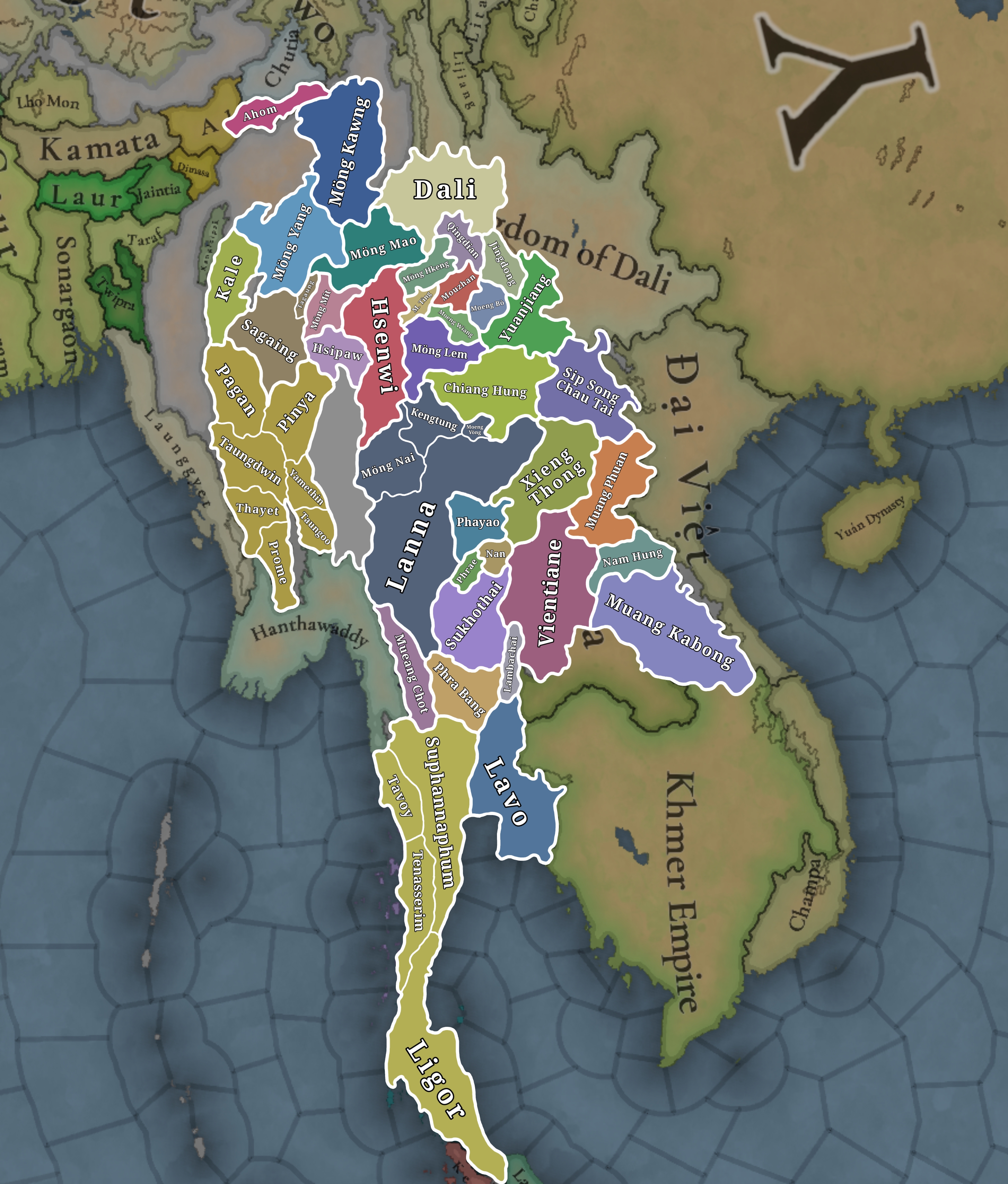
Countries
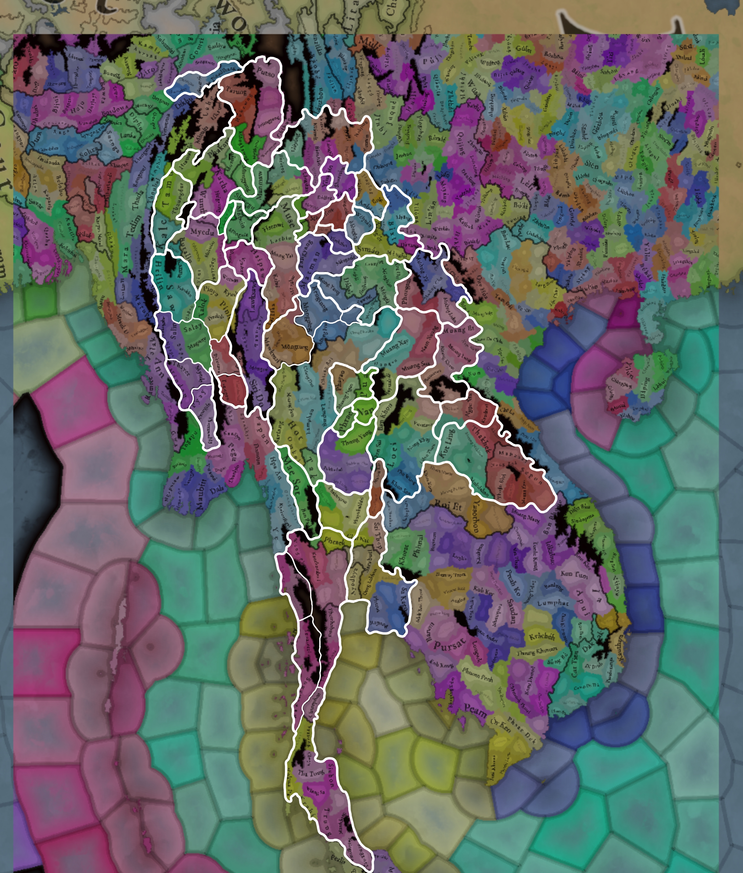
Countries.png
Colored wastelands.png

Quite a variety of countries in the area. The regional power in the decades before 1337 was the Khmer Empire, although at this point they are already in decline and have lost much of their previous hegemony. On the west, the fall of the Burmese Pagan Kingdom and the following Mongol invasions gave rise to the disunited kingdoms of Pinya, Sagaing, Prome, and Toungoo, while in the south the Mon kingdom of Hanthawaddy (also known as Pegu) also split apart. On the center, the decline of the old Lavo Kingdom and its subjugation to the Khmer gave way to the emergence of the Kingdom of Sukhothai when Khmer started its decline too, and Sukhothai is emerging as the dominant Thai kingdom in the area. However, Ayodhya is already gestating the rise of another great kingdom, as King Ramathibodi, the founder of the Ayutthaya Kingdom is already poised to gain power in the region. On the east coast, the Kingdom of Đại Việt is under the orbit of the Yuán, with constant conflict with the southern Hindu kingdom of Champa.

Societies of Pops
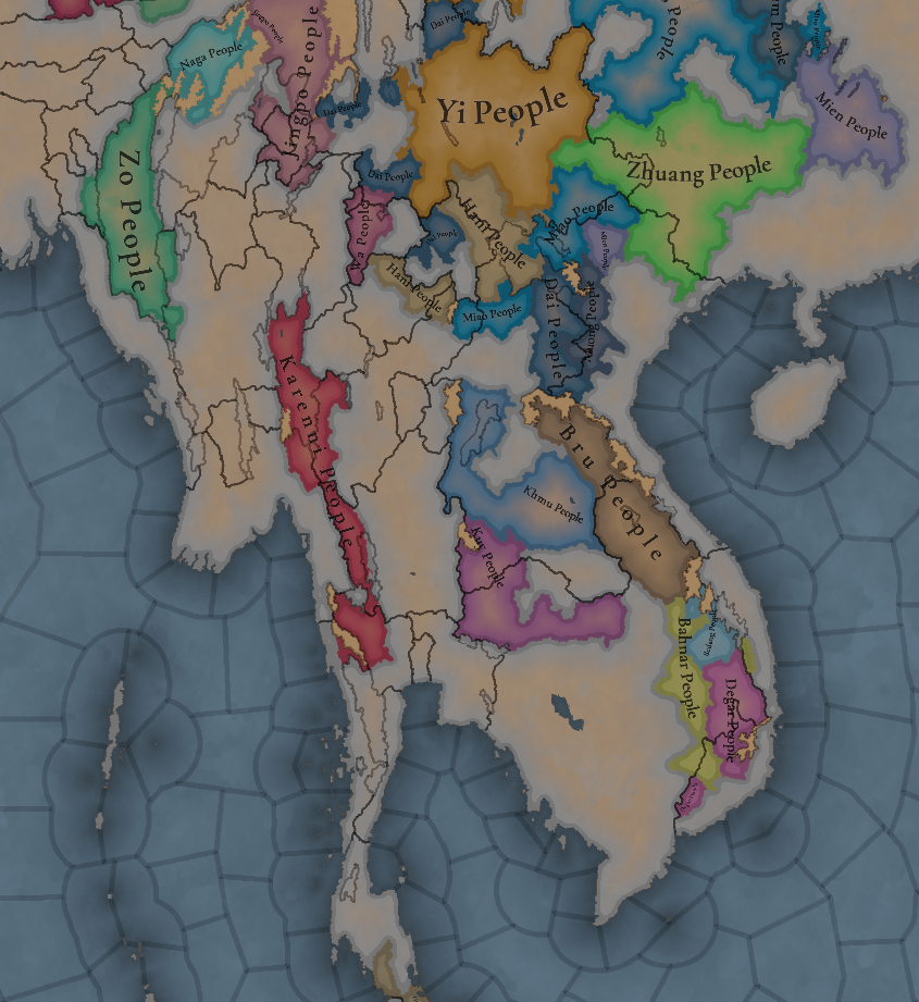
SoP.png

A region very rich in Societies of Pops, which will make it definitely an interesting area.

Dynasties
Dynasties.png

The dynasty of the old Pagan Empire is still alive in Prome, with many other dynasties in the region having ties with it, while the different Thai dynasties also have ties among each other.

Locations
Locations.png

Locations zoom 1.png

Locations zoom 2.png

Locations zoom 3.png

Provinces
Provinces.png

Provinces zoom 1.png

Provinces zoom 2.png

Areas
Areas.png

Unfortunately, currently the name of the sea area encroaches too much into the land (this will be fixed, don’t worry), but the blue area that gets underneath that name is Chao Phraya.

Terrain
Topography.png

Vegetation.png

Climate.png

Tropical and jungle almost everywhere, with quite a bit of comparison between the southern flatlands and the northern mountainous areas.

Development
Development.png

Not as developed as the surrounding India or China, but the main centers of power (like Angkor, Pagan, and Sukhothai) are a bit more developed.

Natural Harbors
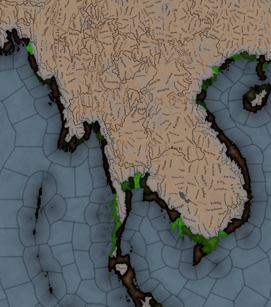
Natural Harbors.png


Cultures
Cultures.png

A quite variety of cultures, although the southern areas haven’t had their minorities done yet so there will be even more variation there.

Languages
Languages.png

As an addition from this week one, we have a new map to show with the languages. Keep in mind that this area hasn't had any language families or dialects done yet, so there is a bit of grouping.

Religions
Religion.png

Again, keep in mind that minorities are not done, so there will be more variation added inside the Theravada block, as there has to be still quite a bit of Hinduism presence in Khmer (its conversion from Hinduism to Buddhism at that point was one of the causes of its decline), and quite a bit more of Satsana Phi among all the Tai peoples.

Raw Materials
Raw Resources.png

Raw Resources zoom 1.png
Raw Resources zoom 2.png
Raw Resources zoom 3.png
Quite a variation of resources, although dominated mainly by lumber and rice.

Markets
Markets.png

The commerce is dominated by those countries benefiting from sea trade routes, but the emergence of a strong Ayutthaya Kingdom in the middle will for sure cause a change in the balance of powers.

Population
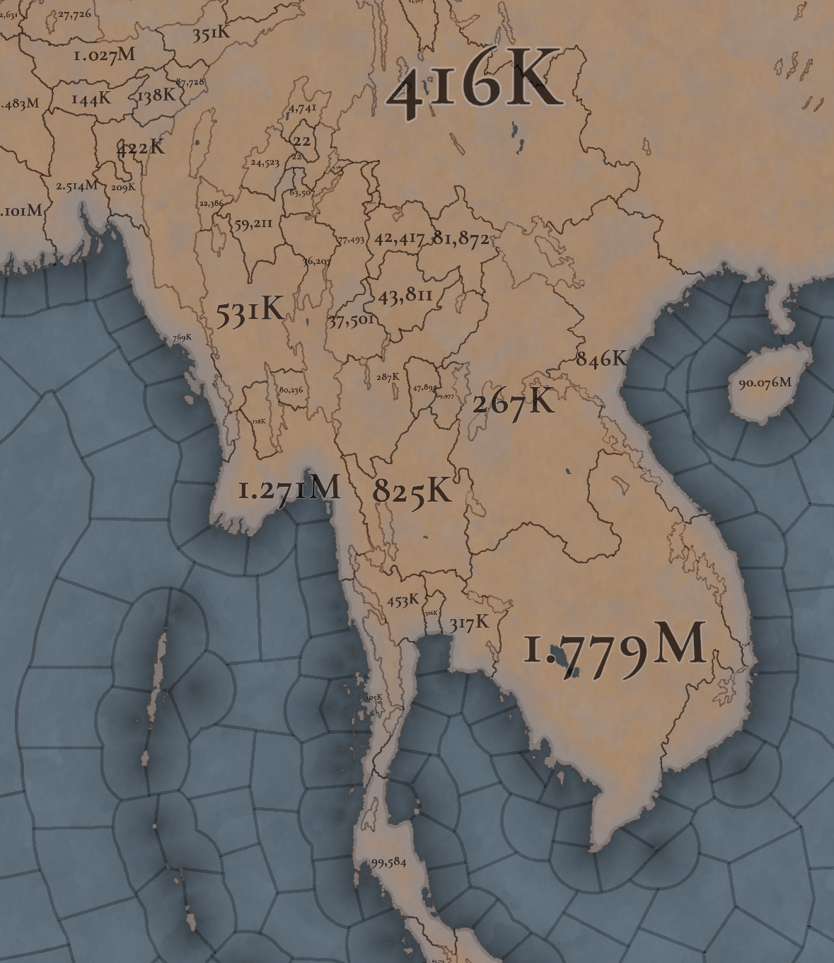
Population.png

Population zoom 1.png
Population zoom 2.png
Population zoom 3.png
Population zoom 4.png
Khmer is still the most populated, but other countries around don’t fall that far behind, especially when they manage to unify their areas a bit. There’s also a couple of locations appearing as 0 population that is definitely a bug that will have to be fixed.

That is all for this week. Join us next week when we set sail to take a look at the maritime part of South East Asia by taking a look at all the archipelago of Indonesia (including the Philippines). Hope to see you there.
 
  • 121Like
  • 40Love
  • 3
  • 1
  • 1
Reactions:
IMG_1974.jpeg
IMG_1971.png
I think it’s better to use Laukkaing instead of Ta Shwe Htan as the name for this location in Myanmar near the border of China. Laukkai or Laukkaing is the name of the city while Ta Shwe Htan is a small town near it. The district is named Laukkaing district. Now most residents in this district are kokang people (name for Han Chinese in Myanmar) due to the Chinese immigrants in Ming and Qing dynasty. In Oct 2023 the 1027 operation starts here as part of Myanmar’s inner conflicts.
 
Last edited:
I have done extensive research about Vietnam (Dai Viet and Champa) in the late Tran dynasty era, especially the 14th century so I have a few comments which I hope that will be incorporated into the game. I am happy to answer questions if needed.

===== Dai Viet politics =====
Additionally, how Vietnamese provinces are decided should be revisit too I think, if possible other Vietnamese can comment on this.

The Dai Viet controlled part in central Vietnam (modern-day Hue) should not be speaking Champa, but maybe a mix of both or a dialect of Vietnamese since that region was controlled by Dai Viet for 30 years already.

I can comment more on the economic and political dynamic of the Tran dynasty if PDX wants to create some disaster events in this period. A brief overview is that Dai Viet's court politics was destroying the country from the inside, and the Buddhist clergy class was influencing heavily during this period which caused a decline in revenue.

===== Champa territory =====
In terms of Champa, the Central Highland of modern day Vietnam should be tribal lands, or at least low control Champa land since Cham people was known to live and mix in the Central Highland. Most notably, the Chams were hiding and fighting guerilla wars from the Central Highland against the Mongols during their 1282 invasion. At the same time, Khmer Empire is exercising very low control on the periphery towards the 1200 and definitely declining in the 1300s, so the border in the map does not make sense. If the PDX believes otherwise, it should be backed up by credible sources.

===== Champa economy =====
While Champa is smaller than Dai Viet in this era with a small agricultural output, Champa trade was flourishing in this era. I think we can reflect this with an event giving Champa trade efficiency/trade power for a period of time in this era (note that this does not last since the Vijaya trade will decline later).

[4] Whitmore, K. J. (2011). The last great King of classical Southeast Asia: "Chế Bồng Nga" and fourteenth-century Champa.
  • As Java’s economy grew, Champa became more involved with it. The Cham ports, especially Sri Chanoy (Thị Nại) in Vijaya, served an important linking role between the Javanese and Chinese ports; as one Chinese source noted, Champa was the way to Java
  • A major recent theme for the discussion of Southeast Asian history has been how the surge of trade in the fourteenth century strongly affected in a very negative way the great classical empires, especially Angkor and Pagan. The coastal regions favored by this commercial surge developed their own strength and undercut that of the classic inland capitals. In the process, Pagan and Angkor would be abandoned and Pegu, Ayudhya and Phnom Penh would rise in their places.
  • Champa was strongly linked to the growing Muslim trade of the era and seems to have joined the Javanese in their embassies to China. Being part of this broad commercial and diplomatic network would have brought the Cham not only to the Chinese capital and its tributary rituals, but also to the opposite pole in the network, that of Java and Majapahit.
As we can see, Champa was benefitting heavily from the Indonesian trade and the rise of Majapahit. Meanwhile, Dai Viet was mostly trading in the Canton node:
  • Canton, however, was the main port of call for the Vietnamese, and they went from there to Malacca on Chinese or Ryukyuan junks. Few Vietnamese ships went directly to Malacca.
===== Champa politics =====
[5] Proctor, Ann R. (2018), Buddhist Art of 9th Century Campa: Đồng Dương, Cambridge Scholars Publishing, p. 140
"Cham societies dominated two-thirds of the narrow central coast of what is now Vietnam for over one thousand years––from the third/fourth century until 1720, when the Cham finally came under the suzerainty of the Vietnamese. The society appears to have been a polity of loosely aligned principalities based in the riverine valleys along approximately one thousand kilometres of the coast. This collection of regional chiefdoms was united by a common language and culture."


===== Final note =====
If you were concerned about more population will skew the balance of the region, you can create rebel events/disasters to balance it out (for example, Dai Viet has a peasant rebellion by Ngo Be in 1344). Having this low population is unplayable in my opinion.
I am also a researcher, specifically of late Champa history, and would like to address this Dev Diary as a whole and also a few points mentioned in the quoted posts (forgive me, I'm not familiar with using this online forum - I can provide links to all of my claims but I did not insert any for fear of being marked as spam).

For the Dev Diary as a whole I will address my concerns moving North to South:
- Điện Bàn on the locations map should be named either Braḥ Kānda according to Cham inscriptions (See inscription C. 1) or Kandarapura (although this area also encompassed the modern city of Hue)

- Kon Klor (Kon K'lor) should be held by Champa at the start (if the game start is 1337). A Champa temple dated to the 10th century with regular signs of use into the 14th century was found at the village of Kon K'lor alongside Champa statues of elephants (mirroring those found in Vijaya) and an inscription (presumed lost now) referenced by Henri Maspero. Local Bahnar oral tradition also reinforces Champa rule in the area.

- Samr̥ddhipurī cannot be the name of this location in 1337 since that is the name of a temple that was founded in 1438 by the Vrsu dynasty in Vijaya (See inscription C. 237). Another possible name could be Hayāv.
- Ia
& Bang Keng seem to coincide roughly with modern day Gia Lai province. This area was well under the control of Champa in 1337. This is evident in the number of Cham temple sites in the region with inscriptions written in Old Cham and dated to the 14th-15th century CE. The following archaeological sites still remain in the area: Bang Kheng Temple (Gia Lai), Yang Mum Temple (Gia Lai), Drang Lai Temple (Gia Lai), Rong Yang Temple (Plei Ku), and the Tư Lương stele (Gia Lai) which is dated to 1438 and discusses ongoing Champa development projects in the region.

- Northern Highland (Province) could be renamed to Madhyamagrama (See inscriptions C. 101, C. 30, C. 43)

- Natural Harbor at Vijaya (Location); there is a natural harbor found off the coast of Vijaya at the ports of Thị Nại & Quy Nhơn as recorded by Champa and Ming sources. Both ports are next to each other so only 1 is needed. (See inscription C. 214 regarding a sanctuary on the Nhơn Hải peninsula)

- Hà Và Nguơn (I could not see the diacritics well) should be Bini in Cham (See Po Dharma, 2001).

- Chan Bo should be Malithit in Cham (See Po Dharma, 2001).

In general, Champa should be a formidable foe for Dai Viet. The 14th century represented a time when Champa was practically united as seen in temple inscriptions from the preceding century and the consolidation of power by Jaya Harivarman in the 12th century. Champa would also go on to sack Angkor and Thang Long (three times) in the 1370s and have the in-game capacity to do so.

Also regarding trade goods, Champa in the 14th century traded extensively in agarwood, ceramics, and salt. The present day regions of Ninh Thuan and Binh Thuan still maintain these trades (see Bau Truc pottery village and/or The fall of Vijaya in 1471: Decline or Competition? by John K. Whitmore)

Now regarding the post I quoted/replied to above:

The southern areas of Hue (as drawn by PDX Province map) should most certainly be speaking Cham and practicing Hinduism. The strongest piece of evidence for this comes from the Lintel at Vân Thê dated to 1346 CE found near a temple site in modern Thừa Thiên Huế. The inscription is written in Old Cham and refers to the restoration of a temple sponsored by a Champa princess dedicated to a deified Cham king/prince named Harijiit. This inscription shows that despite Dai Viet's official control of the area, Cham culture, language, and religion played a major enough role in the area to restore a temple complex to a deified Cham ruler.

We can find additional evidence of the assimilation and integration process used by various Dai Viet (DV) rulers when looking at the conquest of Vijaya by Lê Thánh Tông (LTT) in 1471. The Le dynasty represented a marked shift from previous dynasties in having a more aggressive approach towards dealing with Champa (see Trần Nhân Tông and his stay in Champa). From this, we can infer that areas such as Hue that were given to DV in 1306 (note given not conquered or annexed) still maintained strong Cham influence in the way of language/culture/religion and possibly in terms of local administration.

Following DV annexation of modern day Quang Nam, LTT awarded court positions to two Cham men who had surrendered with the instruction to "execute first and report later".

Vietnamese historian, Phan Khoang commented on the extraordinary power granted to the two Cham governors: "From this power to execute first and report later, we can see the considerable difficulties involved in the pacification of this land, because Cham people's opposition was still strong" (Phan Khoang 1970: 112).

Andrew Hardy, historian of Vietnam's Central Region also noted "Even in this area, which was easily accessible to Vietnamese armies, Lê Thánh Tông's rule depended on the cooperation of Champa's former elite." (Andrew Hardy 2019: 246). Phan Khoang and Hardy's analysis of LTT's annexation of Quang Nam exemplifies how integration of Champa's former territories required Cham cooperation. Hardy concluded it best when stating: "in all the territories of post-1471 Champa, Vietnamese military strength sufficed for conquest but not for rule." (Andrew Hardy 2019: 247).
 
  • 8Like
Reactions:
Screenshot 2024-12-11 at 03.47.43.png
Yao people, or Mien practiced a variation of Daoism, mixing with shamanism and Yao traditions, and use Chinese as their religious language. The earliest record of Yao adoption of Daoism appeared in 1044, and modern Yao established Daoism as their ethnic feature. Almost the whole Yao community is Daoist historically.

Yao in Southeastern Asian also adopted Daoism. https://history.colostate.edu/2020/...t-asia-borderlands-in-asian-ethnicity-vol-18/
Details about their religious practices: https://www.peoplesoftheworld.org/text?people=Mien
 
Last edited:
  • 4Like
Reactions:
I am also a researcher, specifically of late Champa history, and would like to address this Dev Diary as a whole and also a few points mentioned in the quoted posts (forgive me, I'm not familiar with using this online forum - I can provide links to all of my claims but I did not insert any for fear of being marked as spam).

For the Dev Diary as a whole I will address my concerns moving North to South:
- Điện Bàn on the locations map should be named either Braḥ Kānda according to Cham inscriptions (See inscription C. 1) or Kandarapura (although this area also encompassed the modern city of Hue)

- Kon Klor (Kon K'lor) should be held by Champa at the start (if the game start is 1337). A Champa temple dated to the 10th century with regular signs of use into the 14th century was found at the village of Kon K'lor alongside Champa statues of elephants (mirroring those found in Vijaya) and an inscription (presumed lost now) referenced by Henri Maspero. Local Bahnar oral tradition also reinforces Champa rule in the area.

- Samr̥ddhipurī cannot be the name of this location in 1337 since that is the name of a temple that was founded in 1438 by the Vrsu dynasty in Vijaya (See inscription C. 237). Another possible name could be Hayāv.
- Ia
& Bang Keng seem to coincide roughly with modern day Gia Lai province. This area was well under the control of Champa in 1337. This is evident in the number of Cham temple sites in the region with inscriptions written in Old Cham and dated to the 14th-15th century CE. The following archaeological sites still remain in the area: Bang Kheng Temple (Gia Lai), Yang Mum Temple (Gia Lai), Drang Lai Temple (Gia Lai), Rong Yang Temple (Plei Ku), and the Tư Lương stele (Gia Lai) which is dated to 1438 and discusses ongoing Champa development projects in the region.

- Northern Highland (Province) could be renamed to Madhyamagrama (See inscriptions C. 101, C. 30, C. 43)

- Natural Harbor at Vijaya (Location); there is a natural harbor found off the coast of Vijaya at the ports of Thị Nại & Quy Nhơn as recorded by Champa and Ming sources. Both ports are next to each other so only 1 is needed. (See inscription C. 214 regarding a sanctuary on the Nhơn Hải peninsula)

- Hà Và Nguơn (I could not see the diacritics well) should be Bini in Cham (See Po Dharma, 2001).

- Chan Bo should be Malithit in Cham (See Po Dharma, 2001).

In general, Champa should be a formidable foe for Dai Viet. The 14th century represented a time when Champa was practically united as seen in temple inscriptions from the preceding century and the consolidation of power by Jaya Harivarman in the 12th century. Champa would also go on to sack Angkor and Thang Long (three times) in the 1370s and have the in-game capacity to do so.

Also regarding trade goods, Champa in the 14th century traded extensively in agarwood, ceramics, and salt. The present day regions of Ninh Thuan and Binh Thuan still maintain these trades (see Bau Truc pottery village and/or The fall of Vijaya in 1471: Decline or Competition? by John K. Whitmore)

Now regarding the post I quoted/replied to above:

The southern areas of Hue (as drawn by PDX Province map) should most certainly be speaking Cham and practicing Hinduism. The strongest piece of evidence for this comes from the Lintel at Vân Thê dated to 1346 CE found near a temple site in modern Thừa Thiên Huế. The inscription is written in Old Cham and refers to the restoration of a temple sponsored by a Champa princess dedicated to a deified Cham king/prince named Harijiit. This inscription shows that despite Dai Viet's official control of the area, Cham culture, language, and religion played a major enough role in the area to restore a temple complex to a deified Cham ruler.

We can find additional evidence of the assimilation and integration process used by various Dai Viet (DV) rulers when looking at the conquest of Vijaya by Lê Thánh Tông (LTT) in 1471. The Le dynasty represented a marked shift from previous dynasties in having a more aggressive approach towards dealing with Champa (see Trần Nhân Tông and his stay in Champa). From this, we can infer that areas such as Hue that were given to DV in 1306 (note given not conquered or annexed) still maintained strong Cham influence in the way of language/culture/religion and possibly in terms of local administration.

Following DV annexation of modern day Quang Nam, LTT awarded court positions to two Cham men who had surrendered with the instruction to "execute first and report later".

Vietnamese historian, Phan Khoang commented on the extraordinary power granted to the two Cham governors: "From this power to execute first and report later, we can see the considerable difficulties involved in the pacification of this land, because Cham people's opposition was still strong" (Phan Khoang 1970: 112).

Andrew Hardy, historian of Vietnam's Central Region also noted "Even in this area, which was easily accessible to Vietnamese armies, Lê Thánh Tông's rule depended on the cooperation of Champa's former elite." (Andrew Hardy 2019: 246). Phan Khoang and Hardy's analysis of LTT's annexation of Quang Nam exemplifies how integration of Champa's former territories required Cham cooperation. Hardy concluded it best when stating: "in all the territories of post-1471 Champa, Vietnamese military strength sufficed for conquest but not for rule." (Andrew Hardy 2019: 247).
Amazing info and analysis, thank you for your input!
 
  • 1Like
Reactions:
Language notes / Name lists in Burma

Based on the cultures I placed in this post, I think the languages should correspond like this (with scholarly names):

Shan (dialect) - Shan, Ahom, Dai (these should also just be a single culture, excluding Tai Lü and Tai Khün)

Burmish - Burmese, Rakhine, Achang, Danu

Palaungic - Palaung, Wa

Kachinic - Jingpo, Kadu

Karenic - Karen groups (this should be split into more cultures, at least Sgaw, Pa'O, and Pwo)

Kukish - Zo

Naga - Naga (Naga actually comprises of 3 distinct language groups on different branches of Tibeto-Burman, the grouping is more just geographical and convenient)


Name Lists

These are all from the Gazetteer of Upper Burma and the Shan States (this time from this link to avoid print errors and keep accurate names), and some accompanying info about name structures from other books.

Pavía mentioned some things about the name list here, so I'll be going off that for formatting.


Shan

Shan names (and south east asian names in general) are quite different from typical western-style names. They lack surnames, and names are typically made up of multiple particles, including honorifics which are important parts of a name, not just like "Mr" or "Sir" even though you might directly translate them as that. Honorifics and names can often change throughout someone's life, but don't worry if that can't be represented.

For consistency, you shouldn't use any other sources than this for Shan names (including other Paradox games), since the spellings are often different or you get random insertions of Burmese and Chinese translations.

Shan names are scattered throughout the 5 volumes of the GUBSS, mostly in the Hsenwi chronicle and ethnology section of p.1 v.1, and the state histories in p.2 v.1-3. I omitted some names that were repeats, from mythology, or modified into Burmese spelling conventions.

The accent marks I've written here should be included where possible.

Hsö Hkan Hpa
Hsö Pem Hpa
Hsö Wan Hpa
Hsö Sung Hpa
Hsö Hom Hpa
Hsö Yep Hpa
Hsö Hung Hpa
Hsö Wat Hpa
Hsö Wai Hpa
Hsö Kem Hpa
Hsö Pan Hpa
Hsö Pek Hpa
Hsö Paw Hpa
Hsö Peng Hpa
Hsö Saw Hpa
Hsö Um Hpa
Hsö Hat Hpa
Hsö Kat Hpa
Hsö Htam Hpa
Hsö Mawk Hpa
Hsö Sum Hpa
Hsö Sam Hpa
Hsö Rit Hpa
Hsö Hsawng Hpa
Hsö Han Hpa
Hsö Naw Hpa
Hsö Kan Hpa
Hsö Hkai Hpa
Hsö Long Hpa
Hsö Hsi Hpa
Hsö Ngan Hpa
Hsö Kawn hpa
Hsö Ka Hpa
Hsö Kyem Hpa
Hsö Hsen Hpa
Hkam Hawt
Hkam Yawt
Hkam Lat
Hkam Kin
Hkam Wat Hpa
Hkam Tet Hpa
Hkam Pem Hpa
Hkam Hkai Hpa
Hkam Hawt
Hkam Wat Hpa
Hkam Hken Hpa
Hkam Pak Hpa
Hkam Hsen Löng Hpa
Hkam Hküng Hpa
Hkam Hsö Hung Hpa
Hkam Hip
Hkam Kawt
Hkam Leng
Tao Hkun Wen
Tao Noi Chè
Tao Kang Mon
Tao Kang Möng
Tao Hsö Yen
Tao Hsö Han Kai
Tao Hpa Prao
Tao Hkam Wang
Hkun Ai
Hkun Tüng Hkam
Hkun Tai Hkam
Hkun Ai Hawm
Hkun Hkam Sen
Hkun Hkam Hsen
Hkun Hkam Pawng Hpa
Hkun Hseng Pawng
Hkun Tao Hsen Hkam
Hkun Tao Ao Kwa
Hkun Tao Nga Rung
Hkun Hpa Wun Tön
Hkun Tao Lu Lö
Hkun Pan Hsö Long
Hkun Tao Pa Pawng
Hkun Tai Pawng
Hkun Hkam Hken Hpa
Hkun Ta Ka
Hkun Yi Awng
Hkun Sam Hsö
Hkun Ting
Hkun Kom
Hkun Yi Kwai Hkam
Hkun Tum
Hkun Hpang Hkam
Hkun Ai Ngam Möng
Hkun Yi Kang Hkam
Hkun Sam Long
Hkun Tai Hkön
Hkun Tai Hkai
Hkun Tai Tao
Hkun Sam Awn
Hkun Tai Paw
Hkun Pu Hkam
Hkun Ai Long
Hkun Hkam Pem
Hkun Hkam Pot
Hkun Hkam Hom
Hkun Hkam Wat
Hkun Hkam Hung
Hkun Wat
Hkun Ting Hkam
Hkun Kang Hkam
Hkun Hsang Ton Hong
Hkun E
Hkun Hpang Hkam
Hkun Hseng Awng Tun
Hkun Hkam Hkawt
Hkun Hkam Pan
Hkun Kyaw Awng
Hkun Kyaw Noi
Hkun Le
Hkun Lon
Hkun Leng
Hkun Kyi
Sao Hkun Mai Hkam
Sao Tai Pong
Sao Tao Nga Run
Sao Hom Möng
Sao Kaw Leng
Sao Long Tai Long
Sao Hkun Hpö Hsang Kang
Sao Hkun Tai Long
Sao Tai Hkön
Sao Tai Hkai
Sao Tai Tao
Sao Tai Ting
Sao Hkam Awn
Sao Tai Paw
Sao Hkun Hkam Tep Hpa
Sao Saü Pan Noi
Sao Long Hkam Hkai Hpa
Sao Hkam Wat
Sao Long Hkam Hep Hpa
Sao Long Tai Hkam
Sao Hkam Hip
Sao Seng Naw
Sao Mang Tè
Sao Hkam Son
Sao Tai Hkan Hpa
Sao Tai Pong
Sao Tai Long
Sao Noi Hkè
Sao Noi Myen
Sao Noi Hsan
Sao Hkam Pöt Hpa
Sao Hkam Hep Hpa
Sao Hkam Hsen Ahsen Hpa
Sao Hkam Hsö Nan Hpa
Sao Hkam Kai Noi Sao Kin
Sao Hsö Kaw
Sao Hkam Pak
Sao Hkam Nan
Sao Hkun Mawng Lek
Sao Hkam Leng Hsö Hkan Hpa
Sao Naw Hpa
Sao Nan Hpa
Sao Hpa Mawng Hpo
Sao Hkun Hkam Htun
Sao Hkam Pong
Sao Hkun Hkam Naw
Sao Hkun Hkam Kaw
Sao Hkam Kawt
Sao Hkam Htawt
Sao Hkam Mong
Sao Hkam Ung
Sao Hkam Sung
Sao Hkam Kio
Sao Sam Mya
Sao Hkun Hsö
Sao Sawn Möng Hawna
Sao Hkun Pe
Sao Kem Hpa
Sao Loi Hsan Hpa
Sao Peng Hpa
Sao Hkun Möng
Sao Hkam Leng
Sao Hswe Hking
Sao Okka Wara
Sao Okka Seya
Sao Sam Myo
Sao Hkun Neng
Sao Sawra Yawta
Sao Myat Hsan Te
Sao Hkun Hpe
Sao Hswe Kya
Sao Hkun Hkwi
Sao Hkun Paw
Sao Kya Htun
Sao Kya Hkeng
Sao Hke
Sao Kala
Sao Lü
Sao O
Sao Kang Hpa
Sao Sawt Hpa
Sao Ka Hpa
Sao Kai Hpa
Sao Hkio
Sao Maha Hkanan
Sao Maha Pawn
Sao Hseng
Sao Kawng Tai
Sao Hkam Hpu
Sao Kawng Kiao Intaleng
Sao Hak
Sao Nam Nam
Sao Hsam Mun Hwe
Sao Lak
Sao Hsai Nan
Sao Sit Pan Tu
Sao Ai Awn
Sao Hsam
Sao Hsam Sili
Sao Hkam Mu
Sao Möng Hka
Sao Hkam Tao
Sao Möng Hkak
Sao Un
Sao In Hkam
Sao Awk
Sao Möng Lek
Sao Hsam Hpi
Sao Möng Hkawn
Sao Möng Hsam
Sao Möng Kang
Sao Weng
Sao Hsi Hpa
Sao Ngan Hpa
Sao Kawn Hpa
Sao Ka Hpa
Sao Long Tu Möng
Sao Saw Yawt
Sao Long Möng Sang
Sao Ho Tawm
Sao Hon Hpa
Sao Hswi Hpa
Sao Peng
Sao Tit Hpa
Hsang Aw
Kawliya
Santa
Wilahsa
Pansekta
Hsawna
Nanta
Kaw Möng
Sang Hai
Hseng Naw Hpa
Naw Möng
Sün Hpa
Han Hpa Hko Hkam Höng
Hpawng Möng Long Hsüng Wat
Tun U
Sing Kawng
Paw Ai Pyao
Paw Pan Süng
Kang Ai Sum
Ahtama Ting
Nga Lu
Nga Laing
Lao Yom
Pok Nawng Lai
Yi Hkam Hka
Hsai Kaw
Hsai Pawm
Hsen Lam Pan Yang
Sam Long Hpa
Noi Hsan Hpa
Haw Yawt
Haw Hseng
Haw Hkam
Yaw Pan Kyung
San Law
Hsö Peng
Hsö Keng
Hsö Pan
Hsö Han Kak
Nang Ye
Nang Yi
Nang Am
Nang Ai
Nang O
Nang Ok
Nang It
Nang Man
Nang Ngün
Nang Hsoi Hsa
Nang Kaw
Nang Kip
Nang Hkek
Nang Mon
Nang Mai
Nang Ye Hkam Long
Nang Ye Hkam Leng
Nang Ye Hseng
Nang Am Aw
Nang Ye Hkön
Nang Ai Hkam Hpawng
Nang Am Hkawng
Nang Ye Hköng
Nang Hom Möng
Nang Hkan Hkam Hsaü
Nang Hpa Long Hom Möng
Nang Han Hkön Saw
Nang Han Hpa Hko
Nang Naw Hseng
Nang Awn
Nang Hsoi Hkam Möng
Nang Hsum Naw Hseng Pan
Nang Tu Sum
Nang Hseng Pu
Nang Hseng Hkam Mu
Nang Hseng Santa
Nang Hkam Kyi
Nang Hkam Hong
Nang Hsiri Ang Hsung
Nang Hkam Mwe
Nang Hsusa
Nang Mya Suka
Nang Leng
Nang Hkam Mawn
Nang Um
Nang Hkam Ni
Nang Toi
Nang Htai
Nang Ngao
Nang Su Paw
Nang Hkam U
Nang Sam Hkam
Nang Mya
Nang U
Nang Nan
Nang Hkam Lü
Nang Le
Nang Nawn Pè
Sao Mon La
Sao Hkam Leng
Sao Saw Yung
Sao Nang Hsu Wanna
Sao Nang Padumma
Sao Nang Wo
Sao Nang Wen Tip
Sao Tip Hti La
Sao Hkan Hkam
Sao Yong Hkam
Hsu Wanna
Hsu Nanta
I Pawm

There are quite a lot of names, if it's too many then you should prioritise names 3 syllables or under.

Also, my name list includes a lot of Sao, Hkun, Hpa, and Nang, these are honorifics for nobility. If it's possible to have different names for commoners and royalty then you should replace these honorifics with other ones when making the name list for commoners.
Sao (Saopha or royal family)
Hkun (lord / prince)
__ Hpa (lord, placed at the end of a name)
Nang (lady / princess, also used generically for all women today)
Tao (not sure, but it's used in a lot of names of officials and generals, possibly the "Htamong" rank)
Sai (man)
Hkawng (respected adult)
Lung (elderly)
Paw (father)
(mother)
Pa (elderly mother)
Nai (old lady)
Ya (old lady)
Nawng Sai (younger brother)
Nawng Ying (younger sister)
Pi Sai (older brother)
Pi Ying (older sister)
Pu (old man)
Hsang (monk)
Ai (young boy)
Ye (young girl)

Surnames are difficult, because like I mentioned they didn't have any. For the upper class I think you could base them on the names of the main states and locations, and for commoners I guess you could use some common name particles:
Hseng
Hkam
Ngün
Nu
Kwai
Hsö
Pangtai
Ngök
Ngu
Ma
Pe
Ling
Kai
Ma
Sang

(the names from 'Nu' to 'Sang' are actually just animal names from the zodiac, but animal names are commonly given to people so it's probably fine)

Final note, rulers from the Möng Mao dynasty often took the name "Hsö ___ Hpa", I put those names at the top of the male list and their dynasty could be scripted to take only those names, which is something Pavia mentioned was possible.


Palaungic

Palaung names are similar in that they don't have surnames, but they do have clan names which I think work here. I also included Wa clans, but the personal names are all Palaung.

Kyaw Tha
Kyaw Thein
Sam Sa
Sam Zwè
Hla Saw
Twe Hla
Ai Man
Pan Hpyu
Ai Hswe
Hswe Awng
Tôn Hla
Ne Htun

Tawng Peng rulers (names exclusive to upper class?):
Ta Dwè Ba
Ba Kun Mya
Ba Kun Saing
Baw Dwè Taw
Ba Loi Lio
Ba Kan Kein Möng
Ba Kun Hso
Ba Kan Tan Möng
Ba Kan Kun Shin Yè
Kun Kan Kun Ba Hôn Möng
Kun Kan Möng
Hkam Tan Möng
Kun Shin Ga Le
Et Kya
Et Ke
Et Saw
Et Ze
Et Hlu
Et Hwe
Ma Hpe
Et Hpawng
Pan Sōn
I Hsaw
I Hsi
I Hsam
I Ti
I Nu
I Htawn
Palaung:
Kun Hai
Tawng Ma
Samlong
Hpawngmyo
Man Tôn
Ho Kün
Hu Mai
Möng Kwan
Kadu
Padwè
Teao Rai
Kawn Gyawn
Kawn Lè
Pale
Pato Ru
Ôm Ko
Wailông
Serai

Wa:
Hsīn Lam
Hsīn Leng
Hsīn Lai
Hta Mö
Mōt No
Wa Pwi
Wa Lön
En
Sawn
Angku
Pyin
Hsem


Kachinic

Comprising Jingpo (Jinghpaw is probably the better spelling, it's the native form) and Kadu (Asak) languages. I couldn't find any names for Kadu, they were mostly extinct and taking Shan or Burmese names by the time the source was written, so these are all Jinghpaw/Kachin names.

Unlike the other cultures here, they actually did have family names, which are written at the start of the name like in Chinese. There was no distinction between family names for commoners and royalty, though royalty would sometimes use the title "Duwa" instead.

Kam
Nawng
La
Tu
Tan
Yaw
Hka
Hkying
Kum Rawng
Gam
(Note: the source had these listed as 'N Kam, 'N Nawng, etc. but that particle essentially means "child" and is replaced by the family name when they grow up)

Names exclusive to royalty:
Sao Kam
Sao Ri
Sao Ing
Sao Sêng
Sao Naw
Jāli
Jāle Kam
Kum Saing
Kum Jā Kam
Sin Wa Naw
Kumga Naw
Sao Awn
An Nawng
Sao Lawn
Jālāw
La Ring
Saok 'Nwē La
Jā Yit
Jā Tu
Sao Tu
Sao Hlang
Awrā Awrātan
Sao Tan
Sao Yaw
Kaw
Lu
Roi
Tu
Kai
Kha
Pri
Yūn
Khying
Nang
Khying Nang
Khying Tang
(Note: these were also listed with 'N at the start, like the male names, but the same applies)

Exclusive to royalty:
Nang Mun
Jā Taung
Nang Seng
Nang Roi
Nang Hkyeng
Nang Htu
Lasing
Singhtong
Chasham
Langsing
Kawlu
Kambao
Jangma
Lasum
Sumnut
Kareng
Hkuntang
Kumding
Malang
Kangkyi
Chaogyi
Lasi
Labang
'Mbwi
Labya
Mwehpu
Mwehku
Mwehkaw
Sakong
Paosa
Lashi
Chaohpa
Lakang
Sangan
Lukna
Manam
'Nkhum
Paoje
Marip
Lasang
Kumtong
Paosang
Palu
Sabaw
Ningkyem
Maida
Kancma
Shadao
Kangsao
Mitong
Aora
Kumtat
'Ntap
Pumang
Dumao
Lamao
Paoyu
Sinyu
Daoma
Maru
Wuchik
Kinraw
'Ngyi
Paonat
Wudi
Myetshi
'Nlam
Shanghtin
Tashi
Shawunla
Tingrin
Marao
Kaigyi
'Nbrang Paokun
Pasham
Lamai
Paoyam
Tawshi
Gamaw
Galao
Lusing
Sagaw
Paola
Paotai
'Ndao
Palai
Kangda
Paowong
Kumpyen
Lama
Hkrap
Paolang
Chingpaw
Magao
Kumshan
Dingdu
Ningdup
Kataokum
Pao-se
Tao-je
Wapai
Pala
Lebang


Karenic

I think these names could use some fleshing out from other sources, it's a bit of a random mixture between Sgaw, Pa'o, and Pwo names, and baby names. I have a feeling that the female names I listed might be exclusive to babies and not actual adult names. They also lack surnames, and I didn't find any appropriate clan names or name particles.

(possibly baby names):
La È
La Nyein
La Than
La Thè
La Thawk
La Lawk
La So
La Pe

Bawlakè chiefs:
Paban

Kye-bo-gyi chiefs (Karenni/Sgaw):
Hkun U
Daw Ē
Taw Ē
Riraw
Ku-i
Tèpì
Rihaw-i
Mahpo
U Po-i
Sawtha
Ritai
U D
Porè
Roka-i
Klorè
Sa-i
Naw-i
Maw-i
Raw-i
Tamarè
Mirè
Hèrè
Klorè
Naulan
Sawpè
Pyakalè
Lasaw
Laki
Pèthu
Pyarè
Koki
Myarè
Lupè

Gantarawadi chiefs:
Sawlawi
Sawlapaw
Milè
Papaw
Maung Pôn
Sawla-kwè
Sawlasa
Gana
Lakwè
Lapo
Tarulaw
Labow
Nyata
Lano
Kan-u
Kon U
Hkun Li
Hkun Shin Pu
Myedo

Loi Long chiefs:
La-tang
La-ku
La-kawng
La-sa
La-neing
La-tein
La-pye
La-leing
La-müng
Ariya
La-pring
La-tôn
Shwe Gaung
La-saw
La-pau
La-sawng
La-pan
La-lui
Ke-waw
La-tu
Einda
Puseinda
La-naw
Shwe Ni
Shwe Aung
Ba Tin
Nga Po
Hkun Na
Hkun San Da
La-mu
Hkun Pu
Hkun Hkam Chôk
Hkun Tan Gyè
A-mông
I-è-ma
A-la-ma
A-la
A-paing
A-u
A-o
A-e
A-leing
 
Last edited:
  • 8Like
  • 1Love
  • 1
Reactions:
View attachment 1233316

A few extra notes on how to split Shan/Dai/Ahom if at all. I updated the map a little bit, mainly Tai Nüa spreading into Hsenwi, and Tai Lü further south into Lan Na.

The dialects were described like this in 1900: "The differences between Lao, Lü, Tai-lông, and Hkampti are no more marked than between the dialects of
Somersetshire and Wiltshire, and the Mearns, or between Neapolitan and Florentine patois."

I'm not sure if that's more of a reason for or against splitting them lol, but I think it's one of the metrics you're using for splitting cultures so it's relevant. Anyway, there's evidence there was already some difference in dialect in 1337 because the Ahom language most closely resembles the dialect spoken in Mong Mao, which matches their history of migrating from there in the 13th/14th century. Another marked difference between these cultures was their use of different writing scripts (each group I marked also represents a distinct script or writing style which was adopted around the 13th-16th centuries), and the different non-Tai cultures that influenced each group.

The dialects can also be put into 3 categories, Northern (Nüa, Laing, Hkamti, Ahom), Southern (S. Shan), and Eastern (Lü, Khün). This could be an alternative split, but I think if you keep Ahom then you should keep the rest that I marked on the map.

For other, non-Shan, Tai cultures, the eastern Dai locations (in Laos/Vietnam) can become Tai Dam and Tai Dón, and I think Southern Thai could arguably be a separate culture too.


Also here are some bonus Shan location names I found from my time reading the Upper Burma Gazetter:

Sagaing = Hsakawng
Pegu = Paiko
Prome = Möng Pe
Taungoo = Tawngu
Tavoy = Htawe
Pagan = Pukam
Pinya = Pangya
Ava = Möng Angwa
Kūnmíng = Möng Se
I don't think Mong Se refers to Kunming. The Kingdom of Nanzhao also calls itself Meng She, which should be the alternative name for Mong Se. Instead, Mong Se should be an alternative name for Dali. Kunming city was named Sit Zaind (literally the Second City) in the Bai language when the Nanzhao ruler established it as its second capital.
 
  • 2Like
Reactions:
I don't think Mong Se refers to Kunming. The Kingdom of Nanzhao also calls itself Meng She, which should be the alternative name for Mong Se. Instead, Mong Se should be an alternative name for Dali. Kunming city was named Sit Zaind (literally the Second City) in the Bai language when the Nanzhao ruler established it as its second capital.

For the Tai people, it probably became a generic name for Yunnan which ended up being applied to Kunming (Yunnan-sen / Yunnan-fu) in more recent times, but you might be right that it isn't appropriate.

Screenshot_20241219-174339~4.png


Screenshot_20241219-171125~4.png

(Mong Se Long just means "Great Mong Se")

This site also had Kunming listed as Mongsee or "ᥛᥫᥒᥰ ᥔᥥᥴ" (Mong Se)
 
  • 1Like
Reactions:
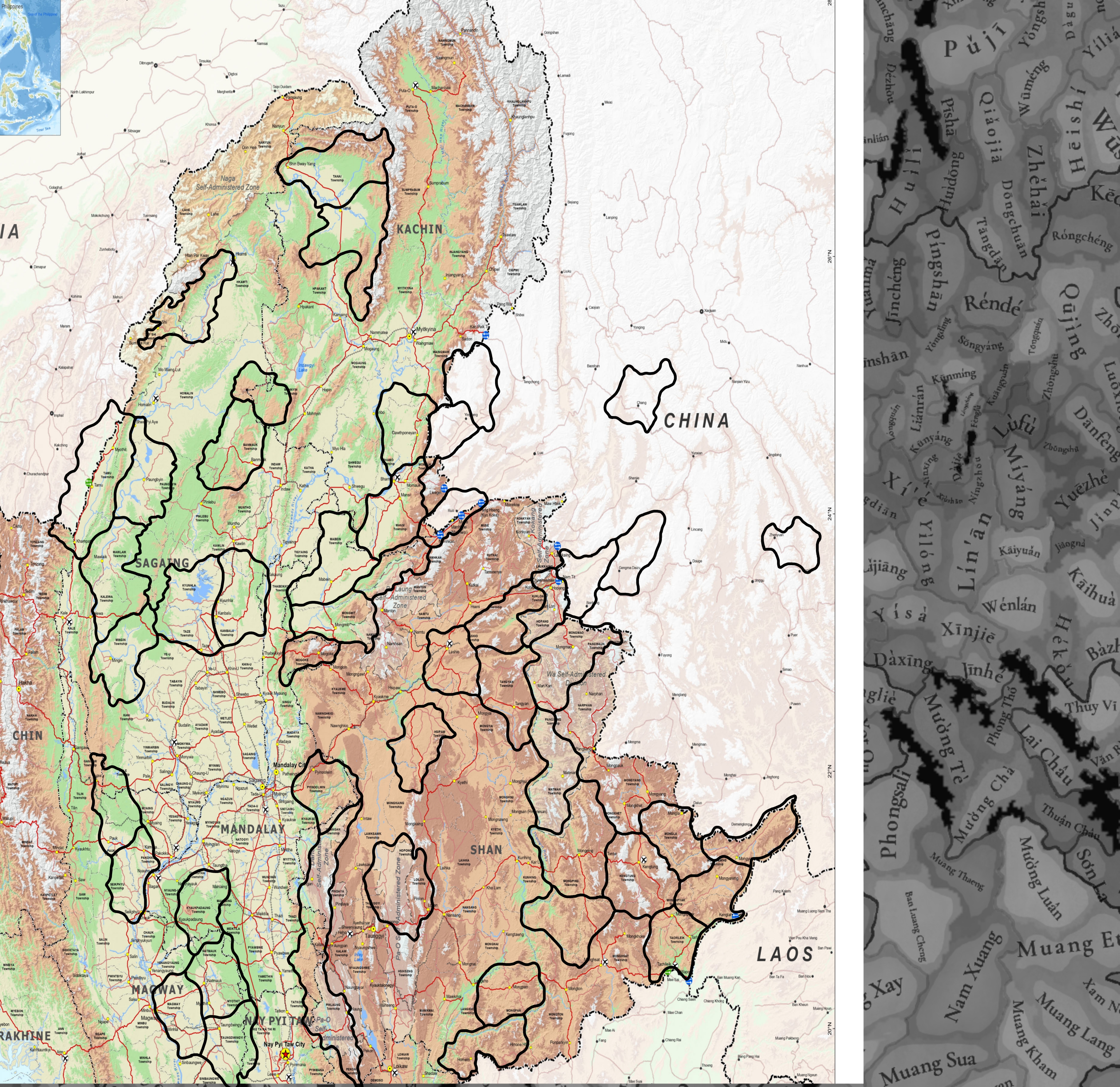
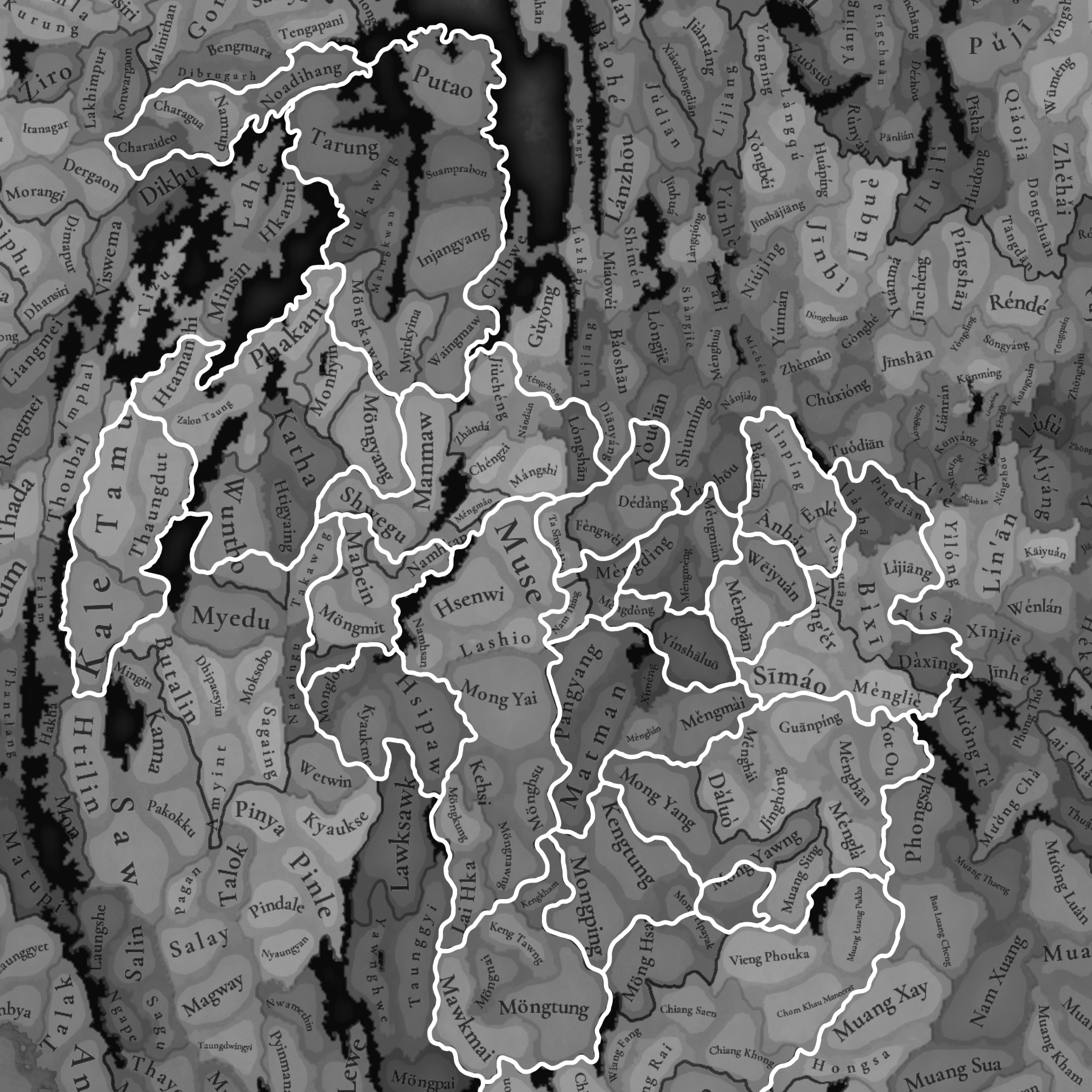
Burma and Yunnan locations

This post focuses on the locations in northern Burma and Southwestern Yunnan.

The first map includes simple name change suggestions to fix inaccuracies, and dynamic names for different languages.

The second map includes suggestions for redrawing locations and possible new additions.


Location Renames / Dynamic Names
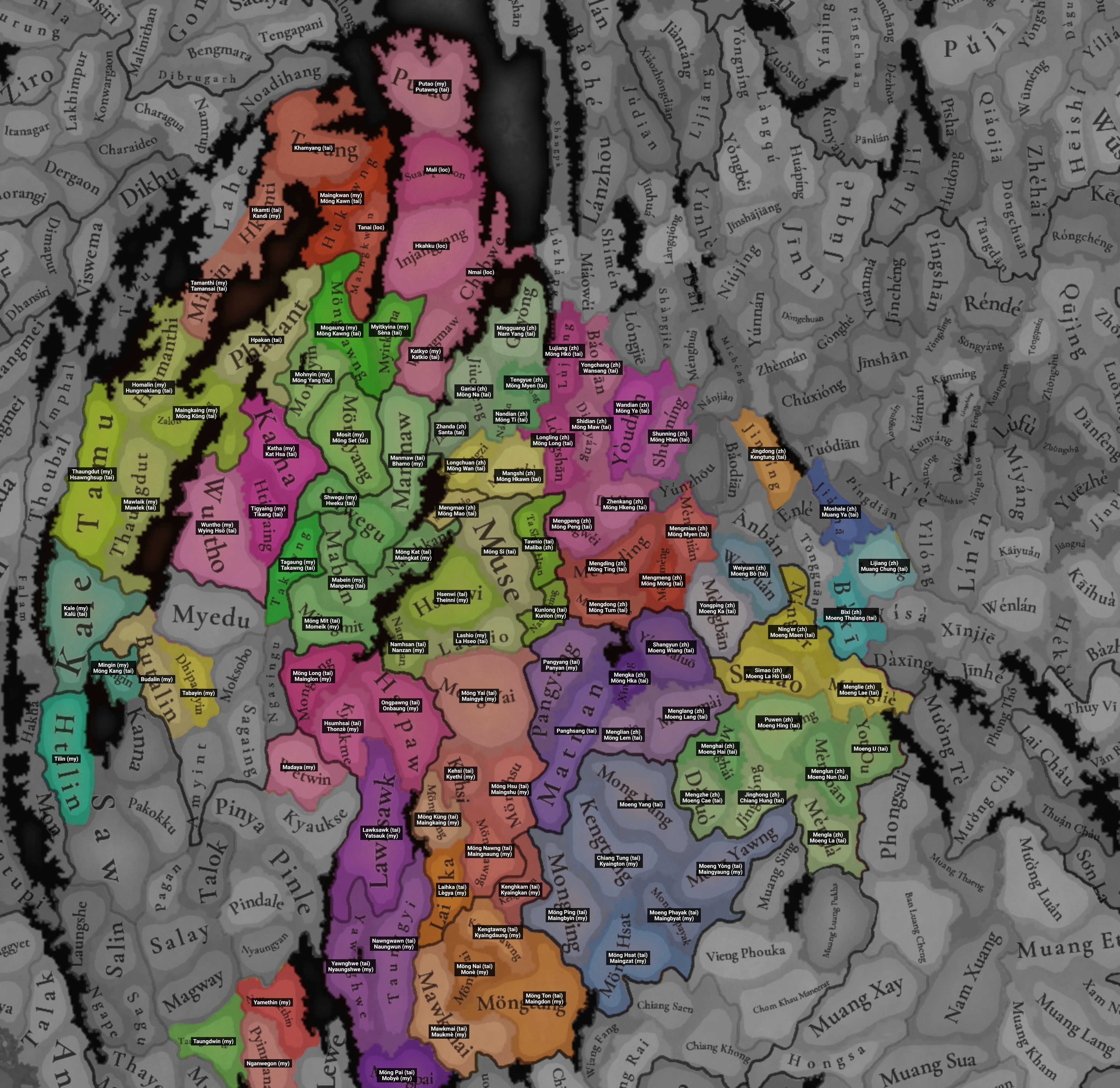
Locations_20250706132939.jpg

Coloured = location with a new name

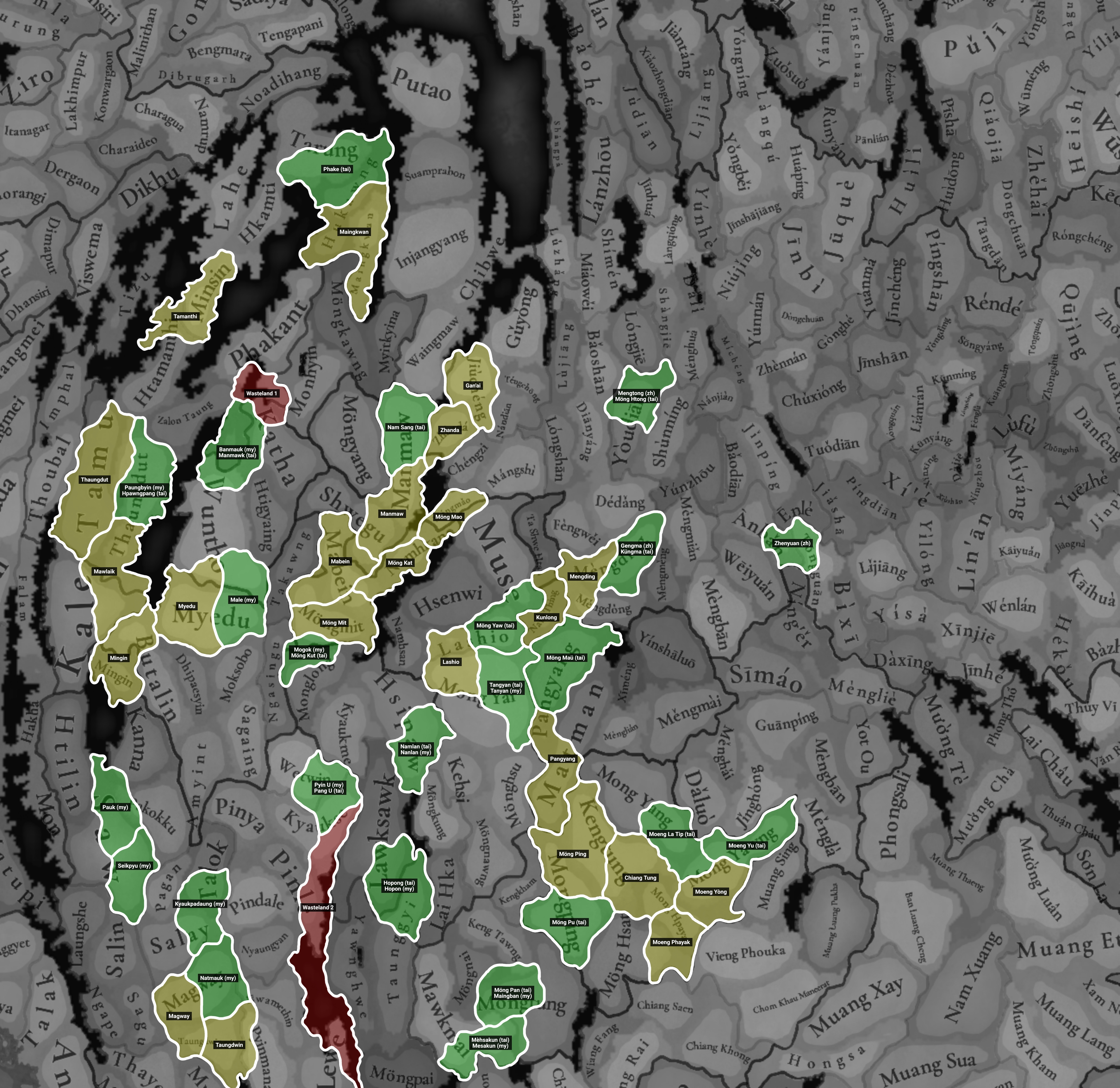
New Locations / Redrawn Locations
Locations_20250706132953.jpg
Locations_20250706133105.jpg
Green = New location
Yellow = Reshaped location
Red = Reshaped wasteland
Second map = display of geography


General sources and explanations:
The names are followed by a label in brackets, corresponding to their language:
(my) = Burmese (Myanmar)
(zh) = Chinese Pinyin (Zhongwen)
(tai) = Local Tai language (Shan, Tai Nüa, Tai Lü, etc)
(loc) = Local name/language, unspecified

For Shan and Tai Nüa names, I've generally followed the traditional British system of transliteration, as this is the most common form which gives us place names like Hsenwi, Hsipaw, Yawnghwe, etc. A chart can be found here, titled "Tables for the transliteration of Shan names into English". I've included Shan script and Tai Le script names where possible, and the original source of them can be found by just searching that Tai script name in quotes on Google, many are on Wikipedia. Additionally, this 1906 map of Yunnan/Burma can be used as reference, along with the Gazetteer of Upper Burma and the Shan States. Since I can't read the Tai Lü script (around Xishuangbanna), as a source for Tai names there I've used the document "Intra-dynastic and Inter-Tai conflicts in the Old Kingdom of Moeng Lü" and the document "The Survival Politics of Three Tai Nüa Polities".

Chinese names follow standard Pinyin for Mandarin, the same as the system used everywhere else in the game. Names can generally be checked in the same way as the Tai names, by searching the Chinese character name in quotes.

I have no clue how to properly transliterate Burmese, so for that I've followed the EKI's Burmese place name list.

Additionally, here are maps of the Yuan-era subdivisions and Ming-era subdivisions.

Source abbreviations:

List: Location Renames / Dynamic Names
Kachin area (areas and original location names correspond to the ones seen in the original Tinto map post)
Original NameNew NameDynamic NamesNotes
TarungKhamyang (tai)--Named after an old place name of the Tai Khamyang people
HukawngMaingkwan (my)Möng Kawn (tai, မိူင်းၵွၼ်း)The original Maingkwan was in the wrong place
MaingkwanTanai (loc)--There are no significant settlements here, so it's just the name of the river
Hkamti-- (unchanged)Kandi (my)--
MinsinTamanthi (my)Tamansai (tai)Source for the Tai name (page 308)
PhakantHpakan (tai, ၽႃၵၢၼ်ႉ)----
Zalon TaungMaingkaing (my)Möng Köng (tai)Mentioned in GUBSS p.2 v.2 page 333. Zalon Taung is the name of a hill, not a settlement
HtamanthiHomalin (my)Hungmaklang (tai, ႁုင်းမၢၵ်ႇလၢင်း)--
TamuThaungdut (my)Hsawnghsup (tai, သွင်သူပ်း)--
ThaungdutMawlaik (my)Mawlek (tai, မေႃႇလဵၵ်း)--
Wuntho--Wying Hsö (tai, ဝဵင်းသိူဝ်)--
HtigyaingTigyaing (my)Tikang (tai, တီႈၶင်ႉ)--
Katha--Kat Hsa (tai, ၵၢတ်ႇသႃ)--
Mohnyin--Möng Yang (tai, မိူင်းယၢင်း)--
MöngyangMosit (my)Möng Set (tai)"Möngyang" is just the Tai name of Mohnyin, which is already a location. Möng Set is mentioned in GUBSS p.2 v.3 page 154
MöngkawngMogaung (my)Möng Kawng (tai, မိူင်းၵွင်း)--
Myitkyina--Sèna (tai, ၸႄႈၼႃး)--
Putao--Putawng (tai)The old name is said to be Putaung, a Tai name, so I would alter this to Putawng to match the rest of the romanization system.
SuamprabonMali (loc)--Sumprabum was not founded until the 19th century, so I would change the name to that of the river, Mali Hka.
InjangyangHkahku (loc)--Injangyang was not founded until the 19th century. Hkahku is the Kachin name of this region.
ChibweNmai--Chibwe also likely wasn't founded until later, so I'd name it after the river, Nmai Hka.
WaingmawKatkyo (my)Katkio (tai)Katkyo was more relevant historically, see GUBSS p.2 v.2 page 572

Irrawaddy area
Original NameNew NameDynamic NamesNotes
Kale--Kalü (tai, ၵႃလိုဝ်း)--
Mingin--Möng Kang (tai, မိူင်းၵၢင်း)--
ButalinBudalin (my)--Minor spelling change based on the EKI place name list
DhipaesyinTabayin (my)--"Dhipaesyin" is mentioned as being the town's name during the Pagan dynasty, but there's no way of telling if it was still the name in 1337, it seems unlikely.
HtilinTilin (my)--Minor change based on the EKI place name list
TaungdwingyiTaungdwin (my)--Historically referred to as just Taungdwin, "-gyi" means "big". See, e.g. Thihapate of Taungdwin
NwamethinYamethin (my)--Wikipedia does say it was formerly known as "Nwamethin", but it likely had changed to Yamethin by 1337. See Thihapate of Yamethin
PyinmanaNganwegon (my)--Older name of Pyinmana, see it's mention on this article for example.

Shan Highlands area
Original NameNew NameDynamic NamesNotes
Manmaw--Bhamo (my)--
Shwegu--Hweku (tai, ႁူၺ်ႈၵူႈ)--
TakawngTagaung (my)Takawng (tai, တႃႈၵွင်)--
Mabein--Manpeng (tai, မၢၼ်ႈပဵင်း)--
NamhkamMöng Kat (tai)Maingkat (my)Namhkam should be part of the Möng Mao location. Möng Kat is mentioned in the GUBSS p.2 v.2 page 377
MöngmitMöng Mit (tai, မိူင်းမိတ်ႈ)Momeik (my)--
MonglongMöng Long (tai, မိူင်းလူင်)Mainglon (my)--
KyaukmeHsumhsai (tai)Thonzè (my)More important historical settlement, see GUBSS p.2 v.1 pages 231–235. Kyaukme has a Burmese etymology so it wouldn't have been founded until much later.
HsipawOngpawng (tai, ဢုင်းပွင်ႇ)Onbaung (my)Ongpawng was the older name of Hsipaw (Thibaw), but realistically either name could be used.
WetwinMadaya (my)--More important settlement located by the Irrawaddy. The Burmese Wiki page says it was founded during the Pagan dynasty
MuseMöng Si (tai)--Muse should be located inside the Möng Mao location
Hsenwi--Theinni (my)--
Namhsan--Nanzan (my)--
Lashio--La Hseo (tai, လႃႈသဵဝ်ႈ)--
Ta Shwe HtanTawnio (tai)Málìbà (zh, 麻栗壩)Older name of the settlement in modern Laukkaing, see GUBSS p.2 v.3 page 263
Nam ThingKunlong (tai, ၵုၼ်လူင်)Kunlon (my)More important settlement, Nam Thing (Ting) is just a river
Mong YaiMöng Yai (tai, မိူင်းယႆ)Maingyè (my)--
Kehsi--Kyethi (my)--
MönghsuMöng Hsu (tai, မိူင်းသူႈ)Maingshu (my)--
MöngkungMöng Küng (tai, မိူင်းၵိုင်)Maingkaing (my)--
MöngnawngMöng Nawng (tai, မိူင်းၼွင်)Maingnaung (my)--
Lai HkaLaihka (tai, လၢႆးၶႃႈ)Lègya (my)--
KengkhamKenghkam (tai)Kyaingkan (my)--
Keng TawngKengtawng (tai)Kyaingdaung (my)--
MöngnaiMöng Nai (tai)Monè (my)--
MöngtungMöng Ton (tai, မိူင်းတူၼ်)Maingdon (my)More common name, I can't find many references to Möng Tung except an unsourced mention on Wikipedia
Mawkmai--Maukmè (my)--
Lawksawk--Yatsauk (my--
Yawnghwe--Nyaungshwe (my)--
TaunggyiNawngwawn (tai)Naungwun (my)Taunggyi was not a significant settlement at all until the British government established it as a capital in the late 1800s. It likely didn't exist at all early on due to its Burmese language etymology.
MöngpaiMöng Pai (tai, မိူင်းပၢႆး)Mobyè (my)--
MongpingMöng Ping (tai, မိူင်းပဵင်း)Maingbyin (my)--
Möng Hsat--Maingzat (my)--
KengtungChiang Tung (tai)Kyaington (my)Chiang Tung is closer to the local dialect
Mong YangMoeng Yang (tai)--This spelling is mentioned in SPTTNP, also helps to distinguish it from "Möng Yang"
Mong HpayakMoeng Phayak (tai)Maingbyat (my)Local Tai rendition of name is mentioned in IDITC, page 86
Mong YawngMoeng Yòng (tai)Maingyaung (my)Local rendition of Möng Yawng

Yunnan area
Old NameNew NameDynamic NamesNotes
Mengmao--Möng Mao (tai, ᥛᥫᥒᥰ ᥛᥣᥝᥰ)
Maingmaw (my)
--
ChengziLǒngchuān (zh, 陇川)Möng Wan (tai, ᥛᥫᥒᥰ ᥝᥢᥰ)
Mowun (my)
--
Mangshi--Möng Hkawn (tai, ᥛᥫᥒᥰ ᥑᥩᥢᥴ)--
Zhanda--Santa (tai, ᥓᥣᥢᥰ ᥖᥣ)--
JiuchengGàn'ái (zh, 干崖)Möng Na (tai, ᥛᥫᥒᥰ ᥢᥣᥲ)--
Nandian--Möng Ti (tai, ᥛᥫᥒᥰ ᥖᥤᥰ)--
TengchongTéngyuè (zh, 騰越)Möng Myen (tai, ᥛᥫᥒᥰ ᥛᥦᥢᥰ)
Momien (my)
GuyongMíngguāng (zh, 明光)Nam Yang (tai, ᥘᥛᥳ ᥕᥣᥒᥰ)Nam Yang is the Tai name of the upper Shweli river
Lujiang--Möng Hkö (tai, ᥛᥫᥒᥰ ᥑᥫᥰ)--
BaoshanYǒngchāng (zh, 永昌)Wansang (tai)Yongchang is the older name of Baoshan. Tai name is mentioned here (page 221)
LongshanLónglíng (zh, 龙陵)Möng Long (tai, ᥛᥫᥒᥰ ᥘᥨᥒ)--
DianyangShīdiàn (zh, 施甸)Möng Maw (tai, ᥛᥫᥒᥰ ᥛᥨᥝᥱ)Möng Maw is actually the name of Jiucheng, another town within Shidian County.
YoudianWāndiàn (zh, 湾甸)Möng Ya (tai)Tai name mentioned in SPTTN (page 134)
Shunning--Möng Hten (tai, ᥛᥫᥒᥰ ᥗᥦᥢᥴ)--
FengweiMěngpěng (zh, 勐捧)Möng Peng (tai)Tai name is a simple transliteration
DedangZhènkāng (zh, 镇康)Möng Hkeng (tai)Tai name is mentioned in the GUBSS, p.2 v.2 page 181
Mengding--Möng Ting (tai, ᥛᥫᥒᥰ ᥖᥤᥒ)--
Mengdong--Möng Tum (tai, ᥛᥫᥒᥰ ᥖᥧᥛᥰ)--
Mengmeng--Möng Möng (tai, ᥛᥫᥒᥰ ᥛᥫᥒᥰ)--
Mengmian--Möng Myen (tai, ᥛᥫᥒᥰ ᥛᥦᥢᥰ)--
Pangyang--Panyan (my)--
MatmanPanghsang (tai)----
XimengMěngkǎ (zh, 勐卡)Möng Hka (tai)Tai name mentioned in SPTTNP (page 233)
Menglian--Möng Lem (tai, ᥛᥫᥒᥰ ᥘᥥᥛᥰ)--
YinshaluoShàngyǔn (zh, 上允)Moeng Wiang (tai)Tai name mentioned in SPTTNP (page 101, footnote 136)
MengmaiMěnglǎng (zh, 勐朗)Moeng Lang (tai)Tai name mentioned in SPTTNP (page 71)
DaluoMěngzhē (zh, 勐遮)Moeng Cae (tai)Tai name is mentioned in IDITC, page 88.
Menghai--Moeng Hai (tai)Mentioned in IDITC, page 64
Jinghong--Chiang Hung (tai)--
Mengla--Moeng La (tai)Mentioned in IDITC, page 67
MengbanMěnglún (zh, 勐仑)Moeng Nun (tai)Mentioned in IDITC, page 64
GuanpingPǔwén (zh, 普文)Moeng Hing (tai)Mentioned in IDITC, page 76
Yot OuMoeng U (tai)--Mentioned in IDITC, page 83
Simao--Moeng La Hò (tai)Mentioned in IDITC, page 52. Called Moeng La Hò in the map on page 54.
Menglie--Moeng Lae (tai)Mentioned in IDITC, page 52
Ning'er--Moeng Maen (tai)Mentioned in IDITC, page 91
MengbanYǒngpíng (zh, 永平镇)Moeng Ka (tai)Mentioned in SPTTNP, page 105
Weiyuan--Moeng Bò (tai)Mentioned in SPTTNP, page 85
JinpingJǐngdōng (zh, 景东)Kengtung (tai, ᥛᥫᥒᥰ ᥖᥧᥒᥴ)--
Bixi--Moeng Thalang (tai)Mentioned in IDITC, page 52
JinshaMóshālē (zh, 摩沙勒)Muang Ya (tai)Muang Ya is the Tai name of the settlement given in this source (page 13)
Lijiang--Muang Chung (tai)Muang Zhong is the name of the settlement given in this source (page 13), though I've used Chung instead of the more Sinicized Zhong, see the Wiki page which calls them Tai Chung instead of Tai Zhong

List: New Locations
Kachin area
NameDynamic NamesNotes
Phake (tai)--Named after the Tai Phake people, who had a settlement called "Phake" in the Hukawng valley. Adding the location allows for distinction between the valley and the mountains to the north.
Banmauk (my)Manmawk (tai, မၢၼ်ႈမွၵ်ႇ)Better represents the geography and removes awkward shapes of locations.
Paungbyin (my)Hpawngpang (tai, ၽွင်းပၢင်ႇ)--
Male (my)--An important garrison town at the time, mentioned in this source (page 219)

Irrawaddy area
NameDynamic NamesNotes
Pauk (my)--Ancient settlement, see GUBSS p.2 v.2 pages 757–759, reduces size of the Saw location
Seikpyu (my)--Better reflection of geography and important settlements by the river
Kyaukpadaung (my)--Ancient settlement according to the Burmese Wiki page, better reflection of the more hilly geography
Natmauk (my)--Better reflection of the hilly geography

Shan Highlands area
NameDynamic NamesNotes
Nam Sang (tai)--River name (see 1906 map) and village (Nam Sang Yang), allows for reshaping of locations in the area to better reflect geography and historical routes.
Mogok (my)Möng Kut (tai, မိူင်းၵုတ်ႈ)Very important location, rich in gems and was directly annexed into the Burmese kingdom in the 1400s, while other areas remained Shan.
Pyin U (my)Pang U (tai, ပၢင်ႇဢူႈ)Better representation of the geography, hilly in the east and (important) valleys in the west. Pyin U is just as old as Wetwin and is a larger, more well-known settlement, see GUBSS p.2 v.2 page 252
Namlan (tai)Nanlan (my)Important settlement, see GUBSS p.2 v.2 pages 616–617
Hopong (tai)Hopon (my)Reduces the size of Lawksawk and is a better representation of the geography
Möng Pan (tai)Maingban (my)Represents the geography better with a border along the Salween river
Mèhsakun (tai)Mesakun (my)Represents the geography better with a border along the Salween river
Möng Yaw (tai)--Helps represent the geography, Möng Yaw was also an important settlement, see GUBSS p.2 v.2
Tangyan (tai, တၢင်ႉယၢၼ်း)Tanyan (my)Better representation of the geography and reduces the size of Möng Yai
Moeng La Tip (tai)--Better representation of geography, better matches the small size of neighbouring locations. The name is mentioned in IDITC, page 80, "Tip" means "little" (see also: Mong La Wiki page)
Moeng Yu (tai)--Needed for political borders, the southern half was occupied by the state of Moeng Yòng while the north was occupied by Chiang Hung and later Chiang Khaeng.
Möng Pu (tai)--Somewhat important settlement, borders reflect those of the later state of Möng Pu.

Yunnan area
NameDynamic NamesNotes
Měngtǒng (zh, 勐统)Möng Htong (tai, ᥛᥫᥒᥰ ᥗᥨᥒᥴ)Needed for political borders, the southern part of the location was part of Zhenkang / Möng Hkeng in 1337 and later independent during the Ming dynasty.
Gěngmǎ (zh, 耿马)Küngma (tai, ᥐᥪᥒ ᥛᥣᥳ)Needed for political borders, the location was split in half in 1337 and during the Ming dynasty by two separate states.
Zhènyuán (zh, 镇沅)--The small area was independent during the Ming dynasty
Möng Maü (tai, မိူင်းမႂ်ႇ)--Needed to decrease the size of locations here which seem to break the 1:3 size rule.

List: Redrawn Locations
Kachin area
NameNotes
MaingkwanMerged the two locations which were originally here. The eastern one lacked any significant settlements throughout history.
TamanthiExtended border south to better include the actual settlement.
ThaungdutChanged shape to better represent political borders, the later state of Hsawnghsup (Thaungdut) would occupy the region explicitly west of the Chindwin river. Also given the northern tip to Imphal to better represent geography.
MawlaikExtended south to better represent geography and historical routes.
MyeduExtended slightly north to represent geography - the border is now drawn at a river.

Irrawaddy area
NameNotes
MinginExtended across the river to better represent historical routes, and to remove awkward location shapes.
MagwayExtended south to better represent geography.
TaungdwinExtended slightly east to better represent geography - this location is a more hilly area.

Shan Highlands area
NameNotes
ManmawExtended southwards into the valley, better represents the geography and removes awkward shapes of locations - the original western part of Shwegu is disconnected from the eastern part by hills.
MabeinMinor adjustments to better represent geography and political divisions.
Möng KatExtended west to represent geography, snaking along the mountainous parts of the river.
Möng MitMinor adjustments to represent historical routes.
LashioExtended south to even out the location sizes and to represent geography.
KunlongExtended slightly north to include the actual settlement in the location and to better represent geography.
Möng PingExpanded east to better represent geography and political divisions.
Chiang TungMoved to the center of the region to better represent the geography and historical routes / important areas.
Moeng YòngReshapen for political borders, this area was owned by an independent state but the northern "panhandle" belonged to Chiang Hung in 1337 and Chiang Khaeng later.
Moeng PhayakExtended southwest so it's not too tiny after other changes.

Yunnan area
NameNotes
ZhandaMild adjustments to represent historical borders.
Gan'aiMild adjustments to represent historical borders.
Möng MaoMild adjustments to represent historical borders and to better represent geography.
MengdingExtended south to represent historical borders and to better represent geography.
PangyangExtended southeast to balance out the location density.

Wastelands
NameNote
Wasteland 1Expanded to represent geography and to cut off Hpakan (Phakant) from southern locations. The area is difficult to traverse even today, and there'd be no real reason to take a direct route instead of going via Mohnyin or the Uyu river.
Wasteland 2Expanded west to better represent geography and political boundaries. The kingdom of Burma historically didn't directly administrate this region, it was owned by local states like Maw.


Last edited:
  • 9Like
  • 4Love
Reactions:
Apart from topography I wanted to try and evaluate two other factors:
- food crop placement
- vegetation

Food crop placement
I tried to evaluate whether the food goods distribution makes sense according to the innate soil fertility.
I discovered there's plenty of potential to rearrange goods like wheat and rice.

Soil fertility depends on a lot of factors, among which cation exchange capacity (='accessible minerals'), potential rooting depth, soil grain size,...
Tropical regions are notoriously tricky for growing crops, as the rainy regions experience a lot of nutrient leeching.

Southeast Asia is no different in this regard.

The FAO has plenty of resources available on the topic, and I recolored their maps for a more intuitive use for our purposes.

Soil Fertility classes, recolored in broad categoriesExtent of Marginal and Very Marginal soil fertility (red line) and the food crop distribution within.Second version where Wheat and Rice are colored bright yellow within the 'infertile zone'Modern population distribution mask, with pitch black having 0 people / km²
View attachment 1214151View attachment 1214152View attachment 1214158View attachment 1214153


Vegetation patterns.

Extrapolating vegetation patterns from modern times back to historical periods is nigh impossible to perform correctly. Nonetheless, often woodlands have been stripped and repurposed for plantations. These plants also photosynthesize, which are also measurable from sattelites. Therefore, the NDVI (Normalized difference vegetation index) is a great tool to visualise relative vegetation density, where plantations are also still recognisable. Of course, forests that were stripped for herbaceous crops will of course appear as grasslands, relatively speaking.

Luckily, the HYDE (History database of the Global environment) also has some indicative models and maps on this subject.

I therefore think that perhaps Khmer-Ayutthaya could use a bit more 'woods' here and there, while central Myanmar is dryer with more grasslands and less dense woodland than currently portayed.

Tinto's vegetation patternSattelite NDVI imagery recolored for vegetation intensity (dark green)"Anthromes" 1300 AD (Hyde 3.3 database)
Brighter = less people = intact wilderness
Population density 1300 AD (Hyde 3.3 database)
View attachment 1214159View attachment 1214161View attachment 1214163View attachment 1214165

I want to add a note to this about the soil fertility map. Basically, after checking a lot of the raw materials in my post above this, it turns out that a lot of areas within the infertile zone were mentioned as being particularly fertile or having rice as their primary/only export or industry. A lot of those regions mentioned actually corresponded with the original placement of rice/wheat by Tinto, but I would still move them around a bit.

I'm not sure what the missing factor is, here are a couple of the examples I drew onto the map:
Soil_Fertility~2.png

It makes sense why Mong Mao and Kengtung were productive, as they're pockets of 'green' soil, Mong Mao was also a densely populated area comparable with central Burma or northern Thailand. Hsenwi is grey and it was mentioned that the green areas below it were still more productive, but Hsenwi itself still had a relatively dense population and exported rice to nearby regions.

This probably applies to other regions too. Basically, green 'pockets' should be excluded from the infertile zone (even though they look small), and grey pockets can be fertile but should have a priority for other goods when they're available. Black areas were always mentioned as having very poor soil, but a couple areas still had hill-rice as the only industry
 
  • 2Like
  • 1
Reactions:
I want to add a note to this about the soil fertility map. Basically, after checking a lot of the raw materials in my post above this, it turns out that a lot of areas within the infertile zone were mentioned as being particularly fertile or having rice as their primary/only export or industry. A lot of those regions mentioned actually corresponded with the original placement of rice/wheat by Tinto, but I would still move them around a bit.

I'm not sure what the missing factor is, here are a couple of the examples I drew onto the map:
View attachment 1238779
It makes sense why Mong Mao and Kengtung were productive, as they're pockets of 'green' soil, Mong Mao was also a densely populated area comparable with central Burma or northern Thailand. Hsenwi is grey and it was mentioned that the green areas below it were still more productive, but Hsenwi itself still had a relatively dense population and exported rice to nearby regions.

This probably applies to other regions too. Basically, green 'pockets' should be excluded from the infertile zone (even though they look small), and grey pockets can be fertile but should have a priority for other goods when they're available. Black areas were always mentioned as having very poor soil, but a couple areas still had hill-rice as the only industry
I agree, the pockets should indeed retain their goods in that case.

The population centres of Mong Mao (and to a lesser extent Hsenwi and Kungtung) regions also light up on the population map.
Sometimes averaging stuff out over the entire Locations surface area ignores the actual IRL situation: fertile valleys in an otherwise infertile region is a human magnet and has the potential for developing a large population centre. They can be especially productive, as all labor efforts are centralised and logistically more efficient.

Same is true for 'fertile land' with low population density: those locations might grow crops really well in theory, but lack of population and infrastructure means there is more subsistence farming than actual export economies.

As always: actual sources about specific locations are always better than an 'averages map', so those should indeed take preference.
 
  • 1
Reactions:
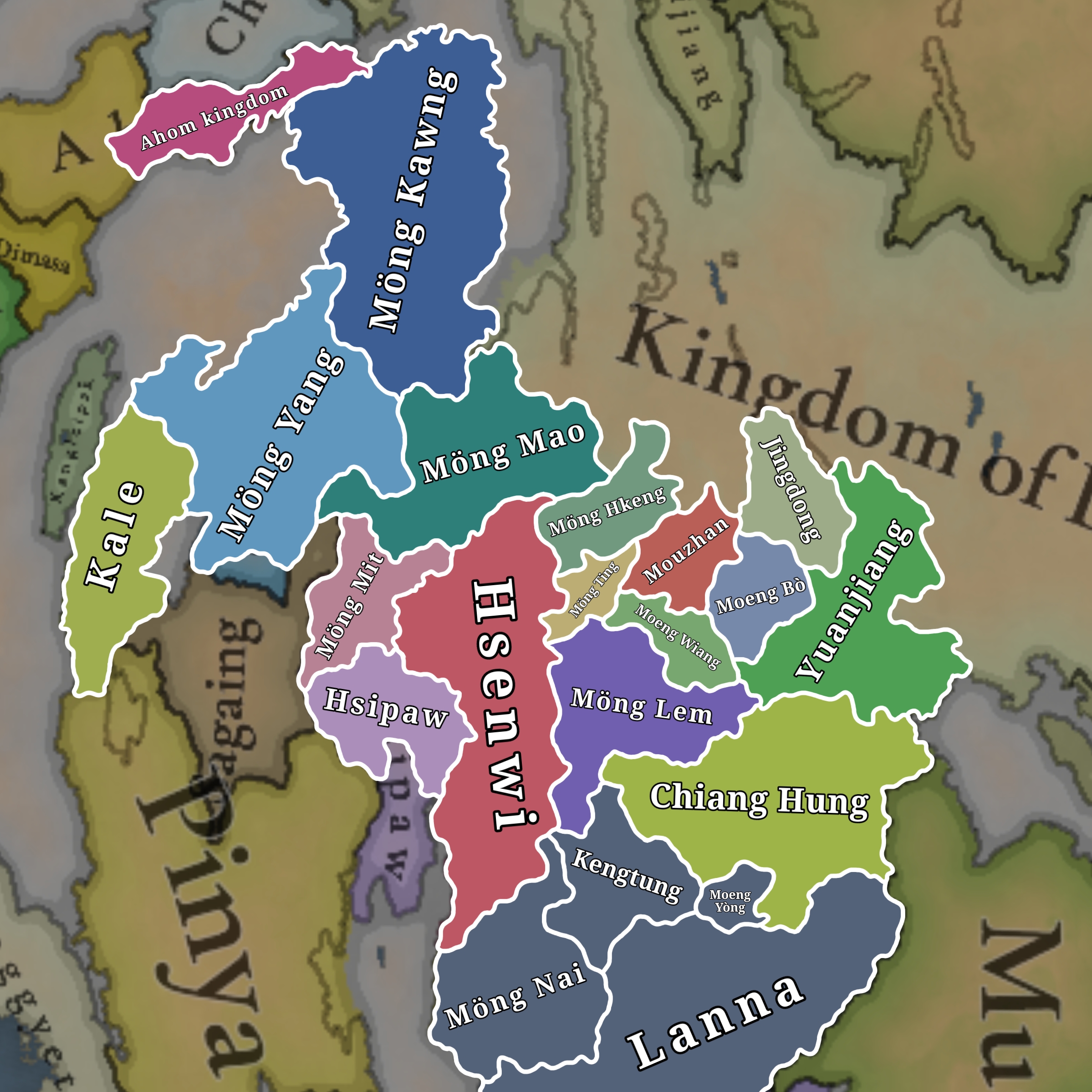
Shan States in 1337

1337 is only a couple years before the rapid rise of Möng Mao, which would go on to conquer most of these states between 1340 and 1360.

Modern historians place the states based on a mixture of Chinese and Burmese sources, along with local Tai chronicles when they all agree with eachother. The sources I've used can be found at the bottom of the post, and I've added page references to my explanations under the Country details spoilered section. For the most part, I have only included countries which are mentioned across Tai, Burmese, and Chinese sources, as relying too much on a single view of history in this region will lead to inaccuracies. Tai chronicles tend to exaggerate the founding date or extent of a local polity, Burmese and Chinese histories tend to have more consistent dates and facts but will miss important local details or names.

Tai states_20250705103015.jpg

The borders on this map can be more accurately represented with my location map, as those locations are more fitting for the borders.
Tai states_20250705105305.jpg


Country details:
Möng Mao
Luchuan, Luchuan-Pingmian

Ruler: Hsö Hkan Hpa (born: 1294)
Capital: Möng Mao

Local Tai chronicles give many detailed accounts of the life of Hsö Hkan Hpa (Sä Khan Fa), but they often assign unreliable starting dates to his reign. According to modern historians, the most reliable of these chronicle dates is 1335 as this lines up with Burmese and Chinese references to Möng Mao's expansion (Daniels, 2018, p. 229). Historians also identify Hsö Hkan Hpa with the figures Chinese and Burmese historical figures Si Kefa and Thohanbwa, who flourished in the mid-14th century (Kirigaya, 2015). Tracing the exact expanion in 1337 is difficult, so I think the likely mid-point for historical accuracy and game balance would be for the country to own the neighbouring Tai states along the Shweli river, i.e. the former states in Luchuan (Möng Mao), Pingmian (Möng Wan), Mangshi/Mangding (Möng Hkawn), Nandan/Nanshan, Zhenxi (Möng Na), Nandian (Möng Ti), and Rouyuan (Möng Hkö), and what was originally Bhamo in the Tinto Maps post.

In Tai chronicles, Hsö Hkan Hpa also had a brother named Sam Long, who was a very skilled general (Scott, 1900, pt. 1, vol. 1). He should begin as a character within the country.


Möng Hkeng
Zhenkang

Ruler: Unknown
Capital: Möng Hkeng (Zhenkang)


Möng Ting
Mengding

Ruler: Unknown
Capital: Möng Ting (Mengding)

Möng Ting was established in 1279 (Zhou, 2024, p. 79).


Mouzhan

Ruler: Unknown
Capital: Küngma (Gengma)

Mouzhan was established in 1326.(https://zh.wikipedia.org/wiki/谋粘路)


Moeng Wiang
Yin Sha Luo Dian

Ruler: Unknown
Capital: Moeng Wiang (Shangyun)

Yin Sha Luo Dian was established in 1329 and governed the land between Möng Ting and Möng Lem (Zhou, 2024, p. 68). It seems to have been locally known as Moeng Wiang, at least this was the name of its capital in 1337. (Zhou, 2024, p. 68, also see other mentions of "Moeng Wiang" throughout the document.)


Möng Lem
Mulian

Ruler: Han Ba Fa
Capital: Möng Lem (Menglian)

Mulian was established in 1289 (Zhou, 2024, p. 68.)


Moeng Bò
Weiyuan

Ruler: Unknown
Capital: Weiyuan

Moeng Bò was established in 1275 (Zhou, 2024, p. 86)


Jingdong
Menggu

Ruler: Unknown
Capital: Jingdong

Jingdong was established in 1331 (Daniels, 2018, p. 231), previously Kainan Zhou.


Yuanjiang

Ruler: Unknown
Capital: Lijiang

Yuanjiang was established in 1288.(https://zh.wikipedia.org/wiki/元江路)


Sipsongpanna
Cheli, Chiang Hung, Moeng Lü

Ruler: Cao Ai or Cao Kham Moeng
Capital: Chiang Hung (Jinghong)

The ruler depends on which primary source is used, Li Fuyi (1947) or Gao Lishi (1984).
Sipsongpanna is a more commonly used name for the state than Chiang Hung. According to the Yuan era map and written accounts (can be found in Intra-dynastic and Inter-Tai Conflicts in the Old Kingdom of Moeng Lü) extended further south. From the linked source, we can see that those areas part of modern Myanmar (Moeng La Tip and Moeng Ma) were gifted to Moeng Khün (Kengtung) in the 1400s, that Chiang Khaeng (Muang Sing) in modern Thailand was founded by a Lü prince.
This source also shows that Moeng Lü was a very decentralised country, and that should be reflected in-game.


Kengtung
Moeng Khün, Chiang Tung

Ruler: Nam Nan (Mangrai dynasty)
Capital: Kengtung

According to "The Northern Tai Polity of Lan Na (Babai- Dadian) Between the Late 13th to Mid-16th Centuries" (p. 6), the ruler of Kengtung should likely be Nam Nan of the Mangrai dynasty, as the dates in the Kengtung chronicle are a few decades off.
It could also be Nam Thuam (a son of Mangrai), but the Kengtung chronicle states that the "son of Mangrai" only ruled for about 11 years after being appointed by Mangrai (Scott, 1900, pt. 2, vol. 1, p. 402), but Mangrai died around the 1310s.


Möng Nai

Ruler: Khun Khüa (Mangrai dynasty)
Capital: Möng Nai

According to "The Northern Tai Polity of Lan Na (Babai- Dadian) Between the Late 13th to Mid-16th Centuries" (p. 34), the ruler of Möng Nai should be Khun Khüa, a son of Mangrai.


Moeng Yòng
Möng Yawng

Ruler: Unknwon
Capital: Moeng Yòng (Möng Yawng)

Moeng Yòng existed in 1337, and should be a tributary of Lan Na, the same as Kengtung and Möng Nai.


Hsenwi
Mubang

Ruler: Hkun Tai Paw
Capital: Hsenwi

Hsenwi (Sënwi) is identified with the Yuan post called Mubang (Daniels, 2018, pp. 227).

Hkun Tai Paw is the ruler of Hsenwi in the Tai accounts of Hsö Hkan Hpa's life (as I wrote earlier, the dates in all Tai chronicles on his reign should be moved to 1335-1370). He seems to have jointly ruled with his son, Tao Noi Chè (Scott, 1900, pt. 1, vol. 1, p. 239).


Hsipaw
Ongpawng, Onbaung

Ruler: Hkun Kyaw Awng
Capital: Ongpawng (Hsipaw)

Hsipaw, called Onbaung at the time, is mentioned in a Burmese inscription of the early 14th century (Kirigaya, 2015, p. 246).
The local Tai history has its ruler as Hkun Kyaw Awng in 1337 (Scott, 1900, pt. 2, vol. 1, p. 216).


Möng Mit
Momeik

Ruler: Sao Tai Hkön
Capital: Möng Mit

Möng Mit, also called Sung Ko (Cun Ko) in Tai chronicles, is identified with the Piaodian polity of Yuan sources (Daniels, 2018, p. 226).
Luce identifies this region with Meng Lai, also mentioned above.(Luce, The Early Syam in Burma's History, pp. 145-146)
Either way, it seems clear that it existed, and it had a very relevant history in Tai chronicles, mentioned across all of the ones I've seen.

In Tai chronicles, Sao Tai Hkön was the ruler of Möng Mit-Sung Ko before Möng Mao's invasion. He seems to have jointly ruled with his 4 brothers (Scott, 1900, pt. 1, vol. 1, p. 239).


Möng Kawng
Mengguang

Ruler: Tai Kham
Capital: Möng Kawng (Mogaung)

Tai Kham (Daihan in Chinese) was the ruler of Mengguang (identified with Möng Kawng) in 1310, and he had a brother or nephew named Sam Lan (Sanlan), they ruled as far as the border with India (Daniels, 2018, pp. 227-228).
Hkamti Long (Putao) is often mentioned as being a dependency of Möng Kawng in this time period (Scott, 1900).


Möng Yang
Yunyuan

Ruler: Unknown
Capital: Möng Yang (Mohnyin)

The Yuan post named Yunyuan is identified with Möng Yang (Daniels, 2018, p. 227).

Wuntho, and other states I previously suggested like Hkamti, Möng Köng and Hsawnghsup, only existed in vague Tai chronicles which were written much kater and have questionable historicity, they didn't exist at all in any contemporary sources from the 14th century unlike all the other states listed here. Even other Tai chronicles disagree on their existence, or only list them as vague place names. J.G Scott also mentions that the local history of Wuntho is "more patriotic than accurate" and it was "never an independent Shan state" (Scott, 1900, pt. 2, vol. 3, p. 362).


Kale

Ruler: Unknown
Capital: Kale

Kale is mentioned in Burmese sources in the 1370s. (Fernquest, 2006, p. 39)
Kale likely existed before that point, and was probably the state on the Chindwin invaded by Möng Mao in 1350s. (Kirigaya, 2015, p. 248)


Ahom kingdom

Ruler: Sukhrangpha (by popular narrative)
Capital: Che Rai Doi (Charaideo)

It's worth mentioning that the state history (buranjis) of the Ahom kingdom claim that its founder Sukaphaa was a brother of Hsö Hkan Hpa. Because of this, you could argue that the Ahom migration of Sukapha should occur 100 years later, the time where we know Hsö Hkan Hpa was alive from modern studies, or that the original Buranjis share the same inconsistencies in dates and details common to many Tai chronicles.

Screenshot_20250522-195553.png

(Daniels, 2000) A map of the Yuan-era native divisions around 1330, before the expansion of Möng Mao.


General References
 
Last edited:
  • 9Like
  • 2Love
  • 1
  • 1
Reactions:
Does anyone have any information about the Laotian principality in the city of Vientiane?


View attachment 1215872
Victorious over his grandfather, Fa-Ngum acceded to the throne of present-day Luang Prabang in 1353. It was then that he gave his kingdom the name of Lan Xang . He imposed his suzerainty on the kingdom of Vientiane and the principalities of Sip-Song-Pha-Na and Lan-Na .
View attachment 1215893
Cobra/Tóushé Kingdom

It's not much, but I recently saw this Chinese map of countries in the 1340s which seems to include it:
d6ca7bcb0a46f21fbe09cf74716e7c600c33874400cb.jpeg


It also includes Muang Phuan in cyan
 
  • 4Like
  • 1
Reactions:
1742939399941.png

I think it would be fair to have separate Pearic and Khmer culture, where first one are tribal slash-n-crop groups and second one are agricultural population.
1742939537707.png

Something like this:
1742939725695.png
 
  • 5Like
  • 1
Reactions:
View attachment 1271557
I think it would be fair to have separate Pearic and Khmer culture, where first one are tribal slash-n-crop groups and second one are agricultural population.
View attachment 1271558
Something like this:
View attachment 1271567
A Pear culture would be cool, but I think your drawing overestimates their extent and underestimates the distribution of Khmer. This is just after the zenith of the Khmer Empire, and Khmer are still fairly widespread in neighboring Thailand even today. I don't see any reason to assume no slash and burn farmers are ethnically Khmer. In fact at this time Pears probably had something of a nomadic hunter-gatherer lifestyle.
 
Last edited:
  • 8Like
Reactions:
Northwestern Tai locations

I've included more than just Tai names, so the title might be a little misleading! But I've focused on the regions which were relevant to Tai people who historically lived in or ruled over the borderlands between what is now India, Myanmar, and China.

I've included name changes, border changes, and new additions. The names and borders are what I think are the most important, I know it's not guaranteed that any new locations will be added but I wanted to include reasonable suggestions for new locations anyway, and I would love to see these in the game! A few are, however, particular important to add and I've included a note for these locations describing why.

My borders are based on the historical maps I could find, the geography, and any written information showing that a settlement belonged to a certain state for most of the time period.


Main map
View attachment 1274312
Higher resolution image below:
View attachment 1274317


Extra maps
View attachment 1274330View attachment 1274331View attachment 1274332
Overlayed on original locationsOverlayed on physical map of MyanmarEmpty "skeleton" overlay


I've done some minor edits to my location suggestions again, just fixing some small spelling inconsistencies and a few borders in the Southeast as I'm working on some suggestions for Lan Na and Laos.

I just want to say it's amazing that the devs are doing this for the entire world, sometimes in multiple languages or dialects which might not have much easily-accessible information. It's not an easy task at all and I think it definitely shows that there's a lot of passion going into the game!
 
Last edited:
  • 2Like
  • 1
Reactions:
Lan Na and Ayutthaya/Sukhothai should still have mostly Mon and Lawa populations in the 14th century:

Screenshot_20250402-083651.png

Screenshot from Wikipedia, Ayutthaya Kingdom

Untitled117_20250402190956.jpg
Untitled118_20250402191227.jpg
Screenshots from The Northern Tai Polity of Lan Na (Babai-Dadian) Between the Late 13th to Mid-16th Centuries, Volker Grabowsky

The Lawa people formed a significant population as far north as Möng Yawng (Müang Yòng) in Myanmar, and possibly further, as shown by the rebellion mentioned in the last screenshot.

The Lawa people's language could fit into the Palaungic language and name list which I suggested in this post. (also, if a dev is reading this as I'm posting it, I edited out some small errors the Shan name list recently, so it would be best to redo the list if they might have already been put into a text file. I promise not to edit it again though!)
 
Last edited:
  • 6
Reactions:
Lan Na and Ayutthaya/Sukhothai should still have mostly Mon and Lawa populations in the 14th century:

View attachment 1275661
Screenshot from Wikipedia, Ayutthaya Kingdom

Screenshots from The Northern Tai Polity of Lan Na (Babai-Dadian) Between the Late 13th to Mid-16th Centuries, Volker Grabowsky

The Lawa people formed a significant population as far north as Möng Yawng (Müang Yòng) in Myanmar, and possibly further, as shown by the rebellion mentioned in the last screenshot.

The Lawa people's language could fit into the Palaungic language and name list which I suggested in this post. (also, if a dev is reading this as I'm posting it, I edited out some small errors the Shan name list recently, so it would be best to redo the list if they might have already been put into a text file. I promise not to edit it again though!)

There would also be some Mon/Monic remnants in the Isan region:

The Kuy people could also be moved further south/east, around southern Laos and northeastern Cambodia, their migration to the current position seems to have happened mostly after the 16th century according to this Wiki article:
Screenshot_20250404-181919.png


Also, regarding the Tboung Khmum kingdom which that article is about, its actual status as a full kingdom seems to be exaggerated and possibly based on a lot of assumptions, there's basically just a single chronicle which mentions a king who was called "Kuy", but it's hard to say without access to the Thai scholarly sources. I think it's fine to keep as a Society of Pops, because even if it existed as a full kingdom we have no way of knowing if it had been established in 1337. The Lao chronicles about the early 1300s even mention other states in the area, including a possibly Cham kingdom or group of city states, which I'll talk about more in another post later.
 
  • 5Like
  • 2
Reactions:
Country suggestions

I've put together some more country suggestions for the region, after reading through enough sources to feel confident about it. I'll split the post into 3 rough sections, Burma, Thailand, and Laos, to keep it easier to keep track of (and write).

Countries_20250705105236.jpg

With current locations for reference:
Countries_20250705105230.jpg


Generally speaking, the 'mandala' political organization of kingdoms can be split into 3 main zones:
1. The "inner core", land ruled directly by the king and his governors.
2. The "outer core", polities ruled by immediate family members (siblings, children, etc) of the king.
3. The "vassal states", polities ruled by local hereditary dynasties.

For the sake of gameplay and mapmaking, I decided to represent the "outer core" as directly owned land rather than vassal states or appanages, except for some unique cases where the area was particularly independent/rebellious in 1337. The "outer core" could be viewed as their own distinct kingdoms, with their own courts and own mandalas, but they were much more fluid arrangements, meaning that it would be difficult to keep track of and represent every arrangement in 1337, and developing a system of gameplay where princes and kingdoms are constantly reassigned and moving just doesn't seem like a good addition unless it's given heavy unique content. It would also run the risk of weakening the kingdoms which have more available sources (i.e. more knowledge about their royal family means more chances to split them), which could just mess up the balance of the region. I have my own thoughts about how the mandala system can be represented fully, and I'll make a separate post on it soon.

Another simplification I made was reducing the amount of polities represented in some places (e.g Laos, central Burma) because if I included every single one it would simply not fit on the map, and again could run the risk of messing up the balance of the region by splitting areas too much. In these cases, I limited it to just the places which had a known ruler name, and/or were significantly independent in reliable sources.

These are not hard rules at all, just helpful guidelines I made for myself to keep things consistent, each region is unique so I'll elaborate on specific decisions and include sources for more/less countries in their specific sections.


1. Burma

I've already made posts on the Shan states, but there are a couple minor changes here to be more consistent with other regions. To fit my general criteria, I have updated my original post on the Shan states, and details can be found there. Some of the countries I previously suggested are now gone, as their existence is extremely doubtful and only based on very vague local legends and lists of place names.

I've also suggested a lot more tags in central Burma, representing the many vassals of the Pinya kingdom. Pinya control didn't extend further than 150km of the capital, and a lot of these vassals were essentially left to fend for themselves. For example, Thayet was invaded by Launggyet in the 1330s and Pinya did nothing about it. All of these states would become completely independent in the 1360s when Pinya collapsed due to invasions by Möng Mao.

Pinya had many vassals, which you can see on their Wikipedia page, I only included vassals outside of the core region, and of those only the ones which have the name of a ruler in 1337. Sagaing only had a single vassal, Tagaung.

New states and their rulers:
Tagaung
Ruler: Thado Hsinlauk
Heir: Thado Hsinhtein

Pagan
Ruler: Uzana II

Taungdwin
Ruler: Thihapate I
Heir: Thihapate II

Yamethin
Ruler: Thihapate
Heir: Thilawa

Thayet
Ruler:
Min Shin Saw


2. Thailand

A lot of the changes here are from 2 main sources, "The Northern Tai Polity of Lan Na (Babai-Dadian) Between the Late 13th to Mid-16th Centuries" by Volker Grabowsky, and "King Lödaiya of Sukhodaya and his contemporaries" by A.B Griswold + Prasert na Nagara. The Ram Khamhaeng inscription is also useful to add some context about some former or current countries, the list of countries is at the bottom of it.

Lan Na:
From "The Northern Tai Polity of Lan Na", it's stated that Lan Na should have Möng Nai (Müang Nai) and Kengtung (Chiang Tung) as subjects. They were both ruled by the same dynasty as Lan Na, but they were much more independent than the states ruled by other family members, and it's explicitly mentioned on page 34 that they fell into category 3 of the simplified zones - vassal states.

On page 9 you can find a table including many of the other vassal states in the northeast. These were mostly ruled by close family members, so they would fall into category 2, the "outer core", and I wouldn't include them as countries without special mechanics.

Chiang Saen would be the most important of those category 2 polities, it was one of the main power centers of the kingdom in 1337, and could possibly be considered the capital. Chiang Saen was ruled by Kham Fu, and Chiang Mai was ruled by his son Pha Yu. Pha Yu inherited the throne of Chiang Saen in 1340, then fully moved the capital to Chiang Mai - this is partly why I didn't think it would make sense to represent category 2 polities as separate countries, they were functionally core regions from a gameplay perspective.

Sukhothai and Ayutthaya:
Sukhothai had already collapsed after the death of Ram Khamhaeng, but the way it's currently represented really underestimates just how much it had lost by 1337. Some of the areas were reconquered by future rulers, which may lead to some confusion.

"King Lödaiya of Sukhothai" goes into details about the reign of Loe Thai (the current ruler), the transliteration system in the book is a bit different from the common type, so I've helped put them into the more common spelling. Original names from the source will be in brackets.

Chapter 2 of the book (pp. 26-47) goes into details about Sukhothai, and the predecessor kingdoms of Ayutthaya, Suphanburi and Lopburi. By 1337, the following events would have occured:

To the north:
- Pua/Nan became independent in 1320.
- Pua (Blua) location annexed by Phayao (Bayāv). This would likely be the date in the 14th century when the name of the country changed from Pua to Nan, so that should be corrected.
- Phrae (Brè) became independent, then may have been subjugated by Lan Na or by Nan, I can't really tell from the wording so I kept them independent on my map.

To the east:
- The upper Sak valley was 'unlikely to have been kept for long' into Loe Thai's reign. The previous state in the upper Sak was Lambachai, mentioned in the Ram Kamhaeng inscription, so this is what I represented. (see map on page 335 https://www.persee.fr/doc/befeo_0336-1519_2021_num_107_1_6377)

To the south:
- Suphannaphum (Subarnapurī) broke away soon after Loe Thai's accession. With that, all areas south of it too.
- Phraek (Brèk / Jayanāda) broke away around the same time.
- In 1331, Suphannaphum expanded to include Phraek (Jayanāda), Ratchaburi (Rājapurī), Phetchaburi (Bejrapurī), Tavoy, Tenasserim, and the Malay peninsula. By the time of the union into Ayutthaya, these were all annexed except for Tavoy, Tenasserim, and the Malay peninsula.
- Royal marriage between Suphannaphum and Lavo, Prince U Thong would be the heir to both, and on his accession he would form Ayutthaya. (Note that this seems to be just one semi-legendary interpretation of U Thong's life, but it is the version from native Thai chronicles, so it's the one I think would be best)

To the west:
- Lan Na (Chiang Mai) seized the principality of Tak in 1321
- Cities further down the Ping river soon became independent, which cut off the route to Mueang Chot and Martaban, making them independent too. Those cities were mentioned before as Khanthi (Gandī), Phra Bang (Brah Paṅ), and (Traitriṅsa). To simplify, I have merged them all into Phra Bang, since they wouldn't all fit on the map.

Also note, the two states Suphannaphum and Lavo should have consistent names with each other, so either both should have the older names (Suphannaphum and Lavo) or both should have their newer names (Suphanburi and Lopburi).


3. Laos

A translation of the traditional Lao chronicles can be found in "History of Laos" by Maha Sila Viravong. Chapter V goes into great detail on Fa Ngum's life (1316-1393), including all of the polities he conquered and the leaders he encountered (pp. 26-35). A similar account can be found on his Thai Wikipedia page, if you translate it, but I didn't think it would be a good idea to rely on that.

The story takes place only about 12-16 years after 1337, so I think it's safe to assume that most of the information would still apply, and having the same rulers would still be reasonable (unless we know from another source that there was a different ruler in 1337).

There are probably 30-40 muang mentioned in the section, but I've vastly simplified it to only those significant countries mentioned in other primary sources. Additionally, half of the locations of these muang are completely unknown, so trying to include them wouldn't be doing much good. It would also likely leave the Lao states too vulnerable to immediate conquest, which didn't really happen historically.

Countries and their rulers:
The original source uses a different transliteration system from the common type, so I've changed the spelling to the more common version where possible. I'll include the original in brackets.

Note that "Phragna" means king or ruler, like Phraya in Thai, but it's common for all sorts of titles to be 'properly' included in Tai ruler names. Some others are Thao, Chao, Khun, etc.

Muang Kabong (Muong Kabong)
Ruler: Phragna Nanthasen
Located in Thakhek. The ruler may have also been Phragna Pad Bo. On the Thai Wikipedia page they seem to be brothers.

Nam Hung (Phra Nam-Hung)
Ruler: Phragna Samkhom
Located near the Nam Kading river in Bolikhamsai.

Muang Phuan (Muong Phuan)
Ruler: Chao Kham Phong
The ruler mentioned in the book is Chet Chuang (Ched Chuong), but this is actually the name of the dynasty and founder of Muang Phuan. Thai Wikipedia has a list of rulers of Muang Phuan, where Chao Kham Phong was the 23rd ruler, ruling until 1895 B.E (Buddhist Era, converts to 1352 C.E)

Sip Song Chau Tai
Ruler: unknown
This is a grouping of the many muang which existed in the north, conquered by Fa Ngum between his interactions with Vietnam and Chiang Hung (Xieng Hung). The name I chose is the one of the later confederation, but there might be a better option for a name, like the Nguu Hong or Cobra kingdom from Chinese and Vietnamese sources.

Xieng Thong
Ruler: Souvanna Khampong
Both of the names of the city, Muang Sua and Xieng Thong, were used in 1337. I would change it to Xieng Thong as that lasted longer after the start date.
The source also mentions Muang Leuak (Muong Leuak) to the west of the capital city, ruled by Thao U-Long, but he was a close family member so I didn't include the country per my own rule about representing immediate family members across the whole region.

Vientiane
Ruler: Thao Xieng Mung
The source also mentions Vieng Kham (near Thoulakhom), ruled by his son Phragna Phao. Again, I didn't include it due to the immediate family rule.
There could also possibly be a country in Dan Sai, ruled by Thao Khai, but the ruler seems to have been possibly related to or otherwise allied with the king of Vientiane, and only Vientiane is ever mentioned in Sukhothai inscriptions, so I elected against including it.

The empty areas south of my drawn countries should likely belong to the Khmer. There are some mentions of of states here in the Lao chronicles, but even if they existed the region is mentioned elsewhere as still being under the influence of the Khmer.
 
Last edited:
  • 13Like
  • 3Love
  • 3
Reactions: