• We have updated our Community Code of Conduct. Please read through the new rules for the forum that are an integral part of Paradox Interactive’s User Agreement.

Tinto Maps #26 - 15th of November 2024 - Indonesia

Hello, and welcome to another week’s edition of the maps of Project Caesar. I hope you have your boat prepared, because today we’ll be doing some island hopping looking at all the archipelago of Indonesia.

Countries
Countries.png
Colored Wastelands.png

Countries zoom 1.png
Countries zoom 2.png
A very wide area filled with many countries. Obviously, the most important emerging power is 
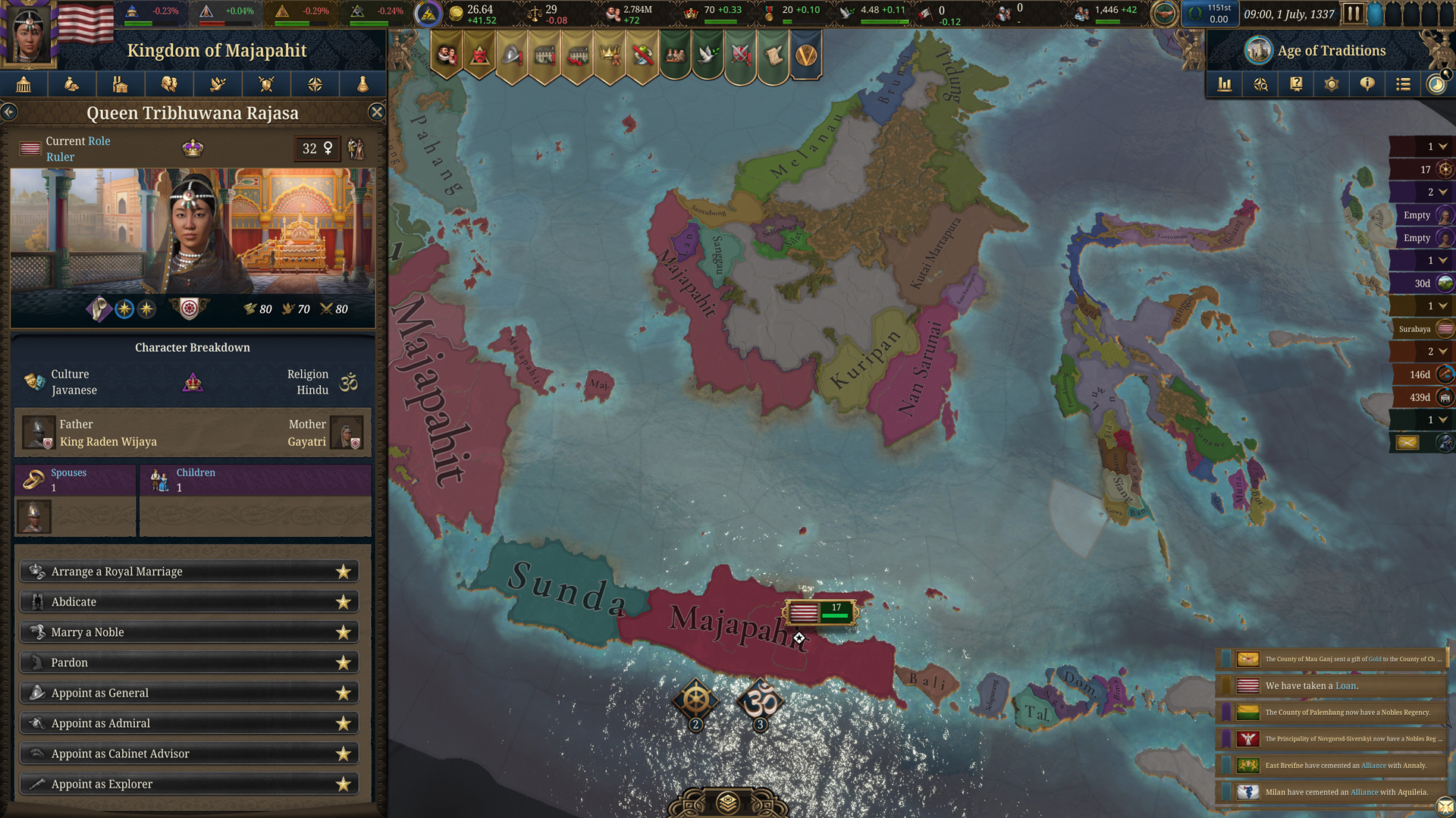
Mahajapit, Majahapit, Mapajahit, Mahapajit, Mapajahit… Majapahit, originating from Java and who are taking advantage of the vacuum created by the disappearance of the Srivijaya Empire to conquer or subjugate many of the Malay polities to establish a new thalassocratic empire. In the island of Borneo, the Kingdom of Brunei is extending its territory with the subjugation of many countries in the Philippines, where the Kingdom of Tondo establishes a certain hegemony but still with many other polities in the islands that could easily take its place. On the Celebes, the island is divided into multiple countries, with the Kingdom of Luwu (starting with L) establishing a firm presence. Further east, Tidore and Ternate are ready to also be very influential polities in the region, despite their humble origins in their small islands.

Societies of Pops
Societies of Pops.png

Not much in here, only the Orang Asli in the Malay peninsula and the Ilocos people in north Philippines.

Dynasties
Dynasties.png

Not much to say here, as much of the dynasties are generated due to the lack of data. Notable exceptions to that are, of course, the Rajasa dynasty of Majapahit and the Mauli dynasty of the Melayu kingdom.

Locations
Locations.png

Locations zoom 1.png
Locations zoom 2.png
Locations zoom 3.png
Locations zoom 4.png
Locations zoom 5.png
Locations zoom 6.png
Locations zoom 7.png
Locations zoom 8.png

Provinces
Provinces.png

Provinces zoom 1.png
Provinces zoom 2.png
Provinces zoom 3.png
Provinces zoom 4.png

Areas
Areas.png

The name of the sea is still encroaching on the land, but this will be solved eventually. Fortunately, the islands make it quite easy to define the areas in this region.

Terrain
Topography.png
Vegetation.png
Climate.png

Vegetation and climate is quite (almost) uniform with tropical jungle, while the topography makes it generally to be quite rugged, with flatlands being present almost only on the bigger islands.

Development
Development.png

As one would expect, these parts are not as developed as what we’ve been seeing recently.

Natural Harbors
Natural Harbors.png

I don’t think it’s to anyone’s surprise that Singapore or Manila turned out to be such good harbors.

Cultures
Cultures.png

Cultures zoom 1.png
Cultures zoom 2.png
Cultures zoom 3.png
Cultures zoom 4.png
Cultures zoom 5.png
I think this may be the most culturally diverse area we’ve presented until now. Keep in mind though that minorities have not been done here yet, so there will probably be more blending and variation in the end.

Religions
Religion.png

Religion zoom 1.png
Religion zoom 2.png
Religion zoom 3.png
Religion zoom 4.png
A foreword before presenting the religions of Indonesia. You might notice that the promise to break the Animist religion into smaller ones is now in full effect. However, this is not going to be the final step, but an intermediate one. We created a lot of different 'culture-based religions' where we knew that people had different believes and rites; now we want to group them into broader categories, that would make sense gameplay-wise, following similarities in beliefs, practices, or mythologies - take as an approximate example the Northern American religions shown in the Religious Overview Tinto Talks. In this regard, we will appreciate any feedback about how to better group these religions, as it will be much easier for us to do it with your help.

With that said, let's focus on Indonesia again. This region is also one of the most varied religion-wise. It is notable the presence of Hinduism and Mahayana, as the prominent countries in this area were Hindu-Buddhists before the arrival of Islam, which is currently just starting to make its entrance through the north of Sumatra.


Languages
Languages.png

One thing I want to say here regarding languages (as for example I saw someone getting surprised by the Mon language presence in the south of the Malay peninsula) is that we have had to make some grouping of languages in certain cases. Among many other issues, languages need to have sets of names for characters, so in cases that we couldn’t find a suitable big enough group of names for a language, we were forced to group it with another one close in their linguistic group (even if just temporarily). We are currently working on improving this, so that we can have the best possible representation without having to compromise gameplay, so it is quite possible that some of the languages that we have been forced to group into bigger groups get further splits in the future. Also, dialects were not a thing yet when we did this area, so nothing about that is implemented here yet.

Court Languages
Court Language.png

Not much difference with the normal languages map, except only in those cases where a country is ruling over another culture (which will be mitigated once minorities are done)

Raw Materials
Raw Materials.png

Raw Materials zoom 1.png
Raw Materials zoom 2.png
Raw Materials zoom 3.png
Raw Materials zoom 4.png
Mainly lumber due to so many jungle, but also some other interesting resources here. And obviously also quite a bit of spices in the Spice Islands.

Markets
Markets.png

Market Languages.png
Added here also the market languages, although keep in mind that it is just the language of the culture of the market center.

Population
Population.png

Population zoom 1.png
Population zoom 2.png
Population zoom 3.png
Population zoom 4.png
Population zoom 5.png
Population zoom 6.png
Population zoom 7.png
Population zoom 9.png
Population zoom 10.png
Majapahit is the most populated, which will help them become the regional hegemon they historically were.

That is all for this week. Don’t put away your boats yet though, as next week we will continue our seafaring adventures and take a look at Oceania. See you there.
 
  • 128Like
  • 45Love
  • 5
  • 3
Reactions:

Barat Daya Islands​

Barat Daya.png

Barat Daya
NoLocationTrade goodsTopographyVegetationNatural harborCulture
1RitabelfruitflatlandjungleRitabel
(decent)
Tanimbar: 100
2SaumlakilumberflatlandjungleSaumlaki
(good)
Tanimbar: 85
Babar: 15
3Babarfishhillsforest-Babar: 100
4Damarcloves / sulphurhillsjungleKenli
(bad)
Leti: 90
Wetar: 10
5Letifiber cropsflatlandforest-Leti: 85
Wetar: 10
Fataluku: 5
6Wetarapiarymountainsforest-Wetar: 90
Fataluku: 5
Mambai: 5
Climate: all tropical

Yamdena island border redraw
Previous border seems forced to include the slightly higher elevation to be part of the southern location.

Saumlaki in Southern Yamdena and Ritabel in Northern Yamdena (technically Larat island)
Both are the modern day center of population and also boast the main ports of the respective location. While there is case where an island name also refers to a specific part of the island, it isn’t the case for Yamdena. Please don’t use Yamdena for a location on the island.

I reckon Sangliat Dol is more thoroughly researched due to the ceremonial artifacts there, knowing that similar structure was found in other villages and that the research doesn't paint picture of Sangliat Dol being a prominent settlement of the island, I feel like using Saumlaki is more suitable to represent the location.

Move Alor location to Flores (East Flores) province
Mostly done on geographical proximity and I suppose I'm influenced by Wetar island being part of Maluku Barat Daya regency in modern day Indonesia while Alor is not.

The Wetar strait situation and general depiction that it's an issue between Maluku and Timor also nudge Alor to be separated.
  1. Wetar and Kisar in Indonesia, and East Timor
Damar trade goods: cloves/sulphur
“...the English were trying to establish themselves on the sulphur-producing island of Damar, and also at a time when Makassar seafarers wrought havoc in the region”
  1. Wetar and Kisar in Indonesia, and East Timor
Teon, Nila, and Serua are three small volcanic islands on Banda Sea, no information on whether nutmeg is actually native here though.
“...VOC had forced the Damme population to destroy more than 14,000 nutmeg trees on the nearby island of Nila”
  1. Damar | Atlas of mutual heritage
Wetar trade goods: apiary
Joannes de Hartog who visited the island in 1681:
“Wetar is actually the inhabitants’ name of the island, which is 70 to 80 miles wide and long. At most places it is full of high and craggy mountains in whose holes and caves the Alfurs live. They have very little communication or intercourse with the coastal dwellers, excepting the barter of beeswax.”
“The land of the lowland Wetar people is famous for having much, nay, even opulent amounts of beeswax.”
  1. Wetar and Kisar in Indonesia, and East Timor
Leti trade goods: fiber crops
Kisar another small island in the archipelago is depicted as part of Leti location
“Kisar would be renowned as a producer of high quality textiles which were exported to the islands in the region”
  1. Wetar and Kisar in Indonesia, and East Timor
Leti itself also produces cloth, but that of lesser quality to Kisar. In general it’s alright to depict this location a fiber crops producing one.
  1. Kisar Textiles 1 - Asian Textile Studies
Saumlaki trade goods: lumber
“A significant number of Tanimbarese artifacts and wood carvings can be found in museums or art exhibitions around the world, with the Tanimbares carving skill recognized throughout history. Forbes (1884, 19) once stated:
Of the intellectual characteristics of the Timor-Laut people I have formed no mean opinion. They are very clever carvers of wood and ivory; the “frame-heads” of their prahus especially attract attention by the elegance of the devices and the excellence of the workmanship. The central pillars in their houses are also most elaborately carved. They are intelligent workmen, and quick at understanding.”
  1. Living Seaward: Maritime Cosmology and the Contemporary Significance of Natar Fampompar, a Stone Boat Ceremonial Structure in the Village of Sangliat Dol, Tanimbar Islands
“Houses of wood and palm leaf, generally on piles, are entered from underneath; their carved pillars show much artistry of construction. The men are skillful boatbuilders.”
  1. Tanimbar Islands | Tanimbar Islands | Traditional Culture, Spice Trade, Wildlife | Britannica
Development
Leti should have slightly higher development than the rest of the locations, serving as a trade post and main producer of quality cloth.

Tanimbar's religion
“At the time when Christianity was introduced, Tanimbarese recognized their own transcendent deity. While the majority of the population have now converted to Christianity, some still follow and acknowledge this earlier faith. This god is addressed by many names such as Mele (Noble One), Ratu, Ratu das, or Ratu-desar (Supreme Lord) in Yamdena or Ubila’a (Supreme Ancestor) in Fordata (Drabbe 1940; McKinnon, 42–45; Pangemanan 2014, 201). This pre-existing belief made the idea of the Christian god introduced by missionaries in 1910 (Pangemanan 2014) more easily accepted by the Tanimbar peoples. Sangliat Dol has had a Christian church since at least 1927 (Pangemanan 2014, 178). Like most villages on the island today, religious ceremonies are held in the church. However, unlike other villages who moved their ritual centers to the church, the people of Sangliat Dol still use the Natar Fampompar for this purpose.”
  1. Living Seaward: Maritime Cosmology and the Contemporary Significance of Natar Fampompar, a Stone Boat Ceremonial Structure in the Village of Sangliat Dol, Tanimbar Islands

Culture
CultureLanguageCulture GroupingCulture Opinion
TanimbarTanimbar-Bomberai (Tanimbar)MoluccanPositive: Evav
Positive: Babar
BabarTimor-Babar (Babar)MoluccanPositive: Tanimbar
Negative: Alor, Buginese, Makassarese
LetiTimor-Babar (Leti)MoluccanPositive: Wetar, Mambai, Fataluku
Negative: Alor, Buginese, Makassarese
WetarTimor-Babar (Wetar)Moluccan; TimorPositive: Leti, Mambai, Fataluku
Negative: Alor, Buginese, Makassarese
While there are some Papuan language traces in Leti location (especially in the village of Oirata in Kisar) and Wetar, I think culturally the society is more like Moluccan and Timor.

Negative opinion on Makassar and Alor
“Makassar activities in eastern Indonesia oscillated between trading and the gathering of sea products, and outright raiding, which partly explains the inclination of many islands in Maluku to accept VOC protection, and to invite Christian rather than Muslim mission.”

"Wetar inhabitants could procure beeswax for the Dutch and were keen to use the VOC for protection against those from the Alor islands and south Sulawesi."
  1. Wetar and Kisar in Indonesia, and East Timor

Positive opinion of Babar and Wetar on East Timor cultures (Fataluku and Mambai)
“People from Timor and the Southwest islands found refuge in each other’s territories, often resettling under peaceful conditions, facilitated by linguistic affinities over the straits as well as the precolonial inter-island network maintained by the trading Kisar. The arrival of European and Eurasian powers, with the establishments of fortified posts in Kisar, Wetar and several places in Timor, broke much of the interaction.”
  1. Wetar and Kisar in Indonesia, and East Timor
The suggestions here are mostly based on King_Potat's post and this map (it's modern but gives decent idea).
- Selaru depicted as Babar.
 
Last edited:
  • 5Like
Reactions:
Looks like new tags were added to the Philippines
1746774373951.png
1746774637328.png


I guess Taytay or Sandao in Palawan, Ibalon (?) in the Bicol region, Maranao and Kiliman in Mindanao. Tondo has been reduced in size.

There might be a tag on the islands of Romblon, but it isn't very clear.

Taken from reddit post.
 
Last edited:
  • 5Like
  • 2Love
Reactions:
This is my first time seeing a depiction of Tribhuwana Wijayatunggadewi and Gayatri wearing vaguely Indian subcontinent-style veil and head jewelry in a Mughal-style palace, and Raden Wijaya wearing Mughal-style helmet. Also, Javanese naming system in this period aren't supposed to follow the given name+family name.

If the devs read this post, I hope this is just a placeholder and will be fixed soon.

Edit: Here's a blog about Majapahit fashion, food, temple, and marriage https://purimajapahit.wordpress.com/

europa-universalis-v-5-__6_.jpg


Tribhuwana Wijayatunggadewi statue for comparison:

Parvati_Majapahit_1.JPG


Gayatri statue for comparison:

Prajnaparamita_Java_Side_Detail.JPG


Raden Wijaya statue for comparison:

Harihara_Majapahit_1.JPG
 
  • 6Like
  • 1
Reactions:
First we gonna talk about Sumatera, heres my recommendation after compiling by sources:
1747838660697.png

A. From Southern Peoples, this is where i born:
> There are trios of Seminung Heritage who Worshipping Kepuyangan (Ancestral Worshiping)
1. Komering
2. Lampung (Pepadun/Coastal; Saibatin/Inland)
3. Ogan

> Then the Highland dudes called: (Kepuyangan -> Sunni)
1. Basemah
2. Rejang
3. Kerinci

> Creole Dudes:
1. Palembang laters (Malays x Javans x Arabic x Chinese) (Hindu Buddhism -> Sunni)

Short story about Palembang
Palembang should have distinct Cultures, Lampung we can break into three provinces, for Palembang and Ogan its too big we can divide them into 8 counties.

Komering Ogan and Basemah was their biggest ethnic group. Also we have study from Suma Oriental at 1500s Lampung wasnt part of Palembang they freed entity same with Bengkulu (but later get vassalized by Pagaruyung & Indrapura at 1347.

Also Malay is not that big and just bordering to Johor, Malacca, Riau, Deli, until Langkat. Palembang is more to Creole culture yes Malay influence them, but its better to separate them alongside with Komering, Ogan, and Basemah which not Malay same like Rejang.

Lot of european explorer wrote that Uluan/Upstreamer/Inland People theyre not Malay sir. Were Uluan.
1747839448344.png


2. Jambi -> Malayized Batin Kerinci and Rimba peoples

> Islanders:
1. Enggano

> Jungle Dwellers: (Bedewo Worshipper & Kepuyangan)
1. Anak Rimba/Dalam/Kubu
2. Batin
3. Sakai


B. Central Peoples:
> East Coast vs West Coast (Buddhism Mahayana/Tantarayana -> Sunni)
1. Maningcabo/Pinangkabo/Minangkabau,
2. Sumatran Malays (Deli, Langkat, Siak, Indragiri)

> Worshipping Fanomba Adu
1. Nias,

> Worshipping Arat Sabulungan
1. Mentawai

> Worshipping Umboh
1. Orang Laut
2. Sekak/Sawang
3. Seletar


C. Northern Peoples
> Worshipping Pelebegu/Parmalim
1. Batak (Toba, Karo, Mandailing, Angkola, PakPak),

> Mostly Hindu-Buddhism -> Sunni
1. Simelue Islander
2. Gayo,
3. Alas & Kluet,
4. Singkil,
5. Acehnese

Here using Project Caesar Map, that my recommendation and fixes:
1747838932758.png

For Powers in 1337 based on latest research:
1747839092539.jpeg


For Terrains Jambi/ Central Sumatra mostly wetlands/swamp alongside the Batanghari Sembilan Rivers like this:
IMG-20250522-WA0010.jpg


In wetlands area live the Batin People, which are wetlanders. Which until now Government still trying to develop that region.

This was latest map i get from Leiden about my hometown Sumatra by K.F. Holle 1887
1747839487399.png

Copyright: My Oganers buddy from @aksara_ogan Instagram and @roemah_soematera community.
 
Last edited:
  • 7Like
  • 2
Reactions:
Now that Venice, "the island" is it's own location. Can we please have Ternate, Tidore, and Banda as their own island location?

On the initial Tinto Map, Ternate and Tidore locations are depicted to own parts of Halmahera island.

Also, Banda is quite isolated in middle of Banda Sea, please don't combine them with Gorom and Watubela archipelago.
 
  • 8Like
  • 1
Reactions:
Historically speaking, it was the Ming dynasty were there was a large number of Chinese immigrants to Southeast Asia. There were some immigrants during the Qing conquest of China, although the numbers dwindled after the country was more stable and the Qing dynasty have more control over the ports. That doesn't mean there weren't any immigrants, but it shouldn't be considered "significant". Significant wave of migration occured only after the opium war, and the majoirty of Southeast Asian Chinese today are of this origin.
Due to paradox's setting, is it possible to put some Chinese diaspora into a place's sub-culture? For example, Hokkien in Tanmasek in the middle of 19ct.
 
  • 2Like
  • 1
Reactions:
Temasek should be a single location kingdom Singapura, ruled by Sang Nila Utama (dynasty Sang Sapurba). It should come with fish as a resource (there were historically very productive fisheries here up till the mid 20th century). The way the coastline is drawn also does not match the real (pre modern day) coastline
1000056361.jpg


Societies of Pops should include the Orang Laut, who inhabited Temasek, the Riau Islands, Johor, and the east coast of Sumatra. They were key to the naval power of the sultans of the area, and acted as pilots for trade ships. Their descendants are still around today.

Klang should not be a good harbour, as the port there dates to the late 19th century British colonial period. Even today the area is actually surrounded by mangroves and less navigable than other places. Melaka (Malacca) should be a good harbour

Beruas and Klang should be wetlands.
Jerantut, Gelanggi, Kuala Lipis should be hills
 
  • 5Like
  • 1
Reactions:
View attachment 1293804

I guess Taytay or Sandao in Palawan, Ibalon (?) in the Bicol region, Maranao and Kiliman in Mindanao. Tondo has been reduced in size.
Tondo was a prominent precolonial polity centered near present-day Manila. While it played a key role in regional trade and diplomacy, its territorial reach is often overstated—especially in modern popular narratives. Neighboring polities such as Namayan and Pasig were likely independent or semi-autonomous rather than fully subordinate. There were also other influential groups nearby, such as those in Pampanga. Tondo should be shown as prominent but not territorially hegemonic across northern Luzon.


Ibalon, associated with the Bicol region, is semi-legendary—rooted in epics like the Ibalong—but there is archaeological evidence of early settlements, pottery, and metalwork. Despite limited historical records, a separate tag may be justifiable for gameplay purposes, especially to reflect early Bicolano cultural identity, in line with Paradox’s precedent for including regionally distinct entities for flavor.


Taytay was a minor coastal settlement noted in Spanish sources from the 16th century. Dozens of such communities existed across Palawan and neighboring islands. It should be treated as a regional-level chiefdom, not as a supra-regional polity or major kingdom.


Sandao, Sanmalan, and similar entries are harder to judge based on current map placement—sources on their exact locations and extents are vague.


As for the other tags: hopefully, they reflect the diversity of the many localized polities, communities, and ethnic groups across the region. That said, many territories appear overextended—several areas, especially inland, were inhabited by distinct native groups not clearly represented.


There’s much more to say about the historical map—it still feels rough around the edges. But this should serve as a starting point for refinement.
 
  • 3
  • 1
Reactions:
Tondo was a prominent precolonial polity centered near present-day Manila. While it played a key role in regional trade and diplomacy, its territorial reach is often overstated—especially in modern popular narratives. Neighboring polities such as Namayan and Pasig were likely independent or semi-autonomous rather than fully subordinate. There were also other influential groups nearby, such as those in Pampanga. Tondo should be shown as prominent but not territorially hegemonic across northern Luzon.


Ibalon, associated with the Bicol region, is semi-legendary—rooted in epics like the Ibalong—but there is archaeological evidence of early settlements, pottery, and metalwork. Despite limited historical records, a separate tag may be justifiable for gameplay purposes, especially to reflect early Bicolano cultural identity, in line with Paradox’s precedent for including regionally distinct entities for flavor.


Taytay was a minor coastal settlement noted in Spanish sources from the 16th century. Dozens of such communities existed across Palawan and neighboring islands. It should be treated as a regional-level chiefdom, not as a supra-regional polity or major kingdom.


Sandao, Sanmalan, and similar entries are harder to judge based on current map placement—sources on their exact locations and extents are vague.


As for the other tags: hopefully, they reflect the diversity of the many localized polities, communities, and ethnic groups across the region. That said, many territories appear overextended—several areas, especially inland, were inhabited by distinct native groups not clearly represented.


There’s much more to say about the historical map—it still feels rough around the edges. But this should serve as a starting point for refinement.
All that's left is to have the polities of Samar and Leyte get some representation. The Visayans or "Pishoye" that raided Taiwan probably came from there. A Spanish priest recorded an epic where a Leyte chief (precursor to the Dapitan Kingdom) raided China to win the hand of a Boholoan princess and in the paper The Visayan Raiders of the China Coast, 1174-1190 AD argues that the raids were perpetrated by the tribes in Northern Samar. It paints an interesting picture of not just the means, but also their motivations when other polities were happily trading and even reducing piracy to not endanger the trade with China.
 
  • 1Like
Reactions:
All that's left is to have the polities of Samar and Leyte get some representation.

Ah yeah, for sure! Nice paper, I've read it fully.


That said, Leyte alone had 3–4 distinct linguistic and cultural groups—mainly Waray and Cebuano-speaking—with shifting inter-polity allegiances, especially in the pre-Hispanic period. A single "Leyte" tag would definitely oversimplify all that.


You could split Waray into at least two peoples (e.g., Northern Samar vs. Eastern Samar/Leyte), given their geographic, dialectal, and political differences. But then again, once you go down that path, you’re in pre-polity microtribe territory—and that's a game design rabbit hole.

(tribe, I just mean, small-scale pre-polity groups). Sidenote. Im not sure if PDX wants to go with Antropoligicval terms like ''paramount chiefdom'' and how Anglofied they want to keep termnologies. Might will be because of translation setbacks as localization.


From a distant, Phil, many places in marimtime S.E.A... It’s kind of a Voltaire's Nightmare situation. Like, sure, you could model 20+ Igorot tribal groups too, but I doubt EU5 will go that granular. For practical reasons, you need some abstraction. (Also, my apologies. - I’m not super deep into the tintotalks, myself—just dropping by since someone asked me, and because I happen to mod EU4 a lot and be the creator of an Asia-focused mod, so I'm not super familiar with their framework for mechanics in the new series.) ;/


As for the Leyte chief epic and the Dapitan Kingdom connection—I’d tread carefully. It’s fascinating, but largely folkloric. There’s a risk in over-historicizing oral traditions without strong corroborating sources, but yeah might not hurt...? (maybe)

That said, this is a great convo to me. There’s definitely room to represent Samar and Leyte more meaningfully without overcomplicating the map. But if they go that route, I hope they apply the same lens to other regions too. -> A lot has already been written—both in the Philippines and the U.S.—about North Luzon, Mindanao, and other areas with rich but underrepresented identities. There’s a whole range of potential tags, cultures, and polities to unpack. But I think they already know?

...Ultimately, it’s up to PDX to decide how deep they want to go and whether they’ll hire or consult the right people for it, like they’ve done in the past. I'm sure they do and have. - But there’s definitely good material out there if they choose to dig into it. It's prob time consuming and maybe kinda investor-tied related, I bet. Art of the deal. But yeah, they're slowly cooking, for sure.
 
  • 5Like
Reactions:
I'm assuming the group of areas shown will be under Indonesia region. And yes, totally missed East Indies. Def the more time appropriate name for the region.
I think the best name for the region would be Nusantara, which is a well-known indigenous name referring to the whole of Maritime Southeast Asia/the Malay Archipelago (the latter being the term used by Alfred Russel Wallace).
 
  • 2
  • 1Like
Reactions:
I wanna analyse the location density here :

1751192443976.png


Most east is the southern part of the Maluku province, today consisting of two regencies. No countries nor SoPs

1751192755574.png

Tanimbar islands, total 4466 km², including 3100 km² Yamdena island and surrounding islets. Split in two locations which seems fine

Southwest Maluku, total 4581 km², consisting of three groups, each with similar population today :
- "Terselatan" consisting of Wetar, Kisar and Romang, 2930 km².
- "Lemola" consisting of Letti, Moa and Lakor, 564 km².
- "Babar" consisting of the other islands, 1087 km².
Now, it seems like Wetar and Barbar have their own locations (each with some surrounding islets), with the rest combined in a third one (though no name is visible, so not sure). If true, that's ok. I'd however defnitily take Atauro island out of the Wetar location, since it's today part of East Timor.

1751194568515.png

Next up is Timor. Timor has a total land area of 30777 km², with 8 locations (one of which also includes the 1280 km² Rote sland to the soutwest). Due to political reasons, this archipelago also includes Atauro (140 km²). Total population today almost 5 million. There's even a country drawn, +- on what's today the main part of East Timor.
In my opinion, Rote should definitely become its own location, and a a few more locations should be added on the main island, let's aim for 12 or so.

Continuing the southern arch, we have the Sawu archipel (460 km²) and Sumba (12500 km²). Now, Sawu is its own location, it seems more logical to combine it with Rote?
Sumba has 3 locations, where at least one, preferrably two should be added.


East of Flores, there are (always including surrounding islets) :
- Alor island 2066 km²
- Pura island 28 km² (between Pantar and Alor)
- Pantar island 771 km²
- Lembata island 1266 km²
- Adonara island 511 km²
- Solor island 218 km² (south of Adonara)
Currently, the first three are one location, as are the latter three (with Solor seeming cut in half, I'd guess by mistake ?). The last one is part of a country that also owns eastern Flores
I'd definitely make Alor its own location, taking Pura and Pantar out of it (almost double the size of Sawu, which merited its own location, so seems fine. I'd like to also split Adonara/Solor from Lembata, but that's less important

Flores itself is 14154 km², excluding surrounding islets like 390km² Komodo and 180km² Rinca. Combining those two with the eastern-Sumbawa islet of Sangeang (166km²) and the smaller islands in the vicinity, would make for a Komodo island location, great for flavour :). RIght now, there's 5 locations on Flores, the easternmost one part of a country that also includes the first island location east. As with Sunda, adding at least one, preferrably two new ones should be envisaged (of course, not counting the Komodo island location).

Then come Sumbawa's 14400 km² (excluding islets like 350 km² Moyo). That makes it larger than Flores, with more islets and more interesting geography (including the Tambora volcano). In this proposal, there are 4 locations, each with their own country. I'd like at least 3 or 4 locations west of the bay, one south and 5 or 6 east. Adding at least one wasteland in the eastern half should definitely be envisaged.

Lombok is 4600 km², two locations for one nation. Adding a third locations seems logical, especially if it could be done in a way to make the wasteland on the north side gameplay-relevant.

Lastly, there's 5780km² Bali including islets like 315km² Klungkung, consisting of one country with three locations. Because it's Bali, I'd prefer adding a fourth location.

edit : the map of location borders (number showing the amount of locations on the larger islands)
1751198181626.png
 
Last edited:
  • 3Like
  • 1
Reactions:
We'll see the full changes to Indonesia next week, but some of them are listed in the latest South East Asia feedback

New TAGS, locations and provinces renamed and revised language and culture groups
1751899879145.png
 
  • 5Like
Reactions: