• We have updated our Community Code of Conduct. Please read through the new rules for the forum that are an integral part of Paradox Interactive’s User Agreement.

Tinto Maps #29 - 13th of December 2024 - Central America

Hello everybody, and welcome to Tinto Maps, the happy Fridays for map lovers! Today, we will be looking at Central America, which includes the Caribbean. Before we start, I want to introduce you @RaulTrullenque , the only member of our Content Design team who had not yet gone public, and who worked really hard on the maps and content of the Central American and South American regions.

And now let’s get started without further ado!

Countries
Countries1.png

Countries2.png

Countries3.png

Countries4.png

Countries5.png

Countries6.png

Countries7.png

Tenochtitlan.png

Mayan.png
Welcome to the Mesoamerican Thunder Dome! This area is characterized by its numerous Altepetl, more or less comparable to city-states. Most of them are ruled in 1337 by peoples of Nahua origin, something that you may see much more clearly in the culture map. The biggest power in this moment is the Empire of P’urhépecherio, though, founded by the Purepecha people. In any case, you may notice that there’s a lot of detail in this area, including a tiny Nahua settlement recently founded on an island over Lake Texcoco, Tenochtitlan. This is the first time in a PDX GSG that we have the island itself present on the map, although the location covers some more land over the lake coast, to make it playable. Finally, we also have the Mayan polities of the Postclassic Period, of which Cocom, with its capital Màayapáan, was the most important, along with others, such as K’iche’ and its capital Q’umarkaj.

SoPs
SoPs1.png

SoPs2.png

SoPs3.png

SoPs4.png
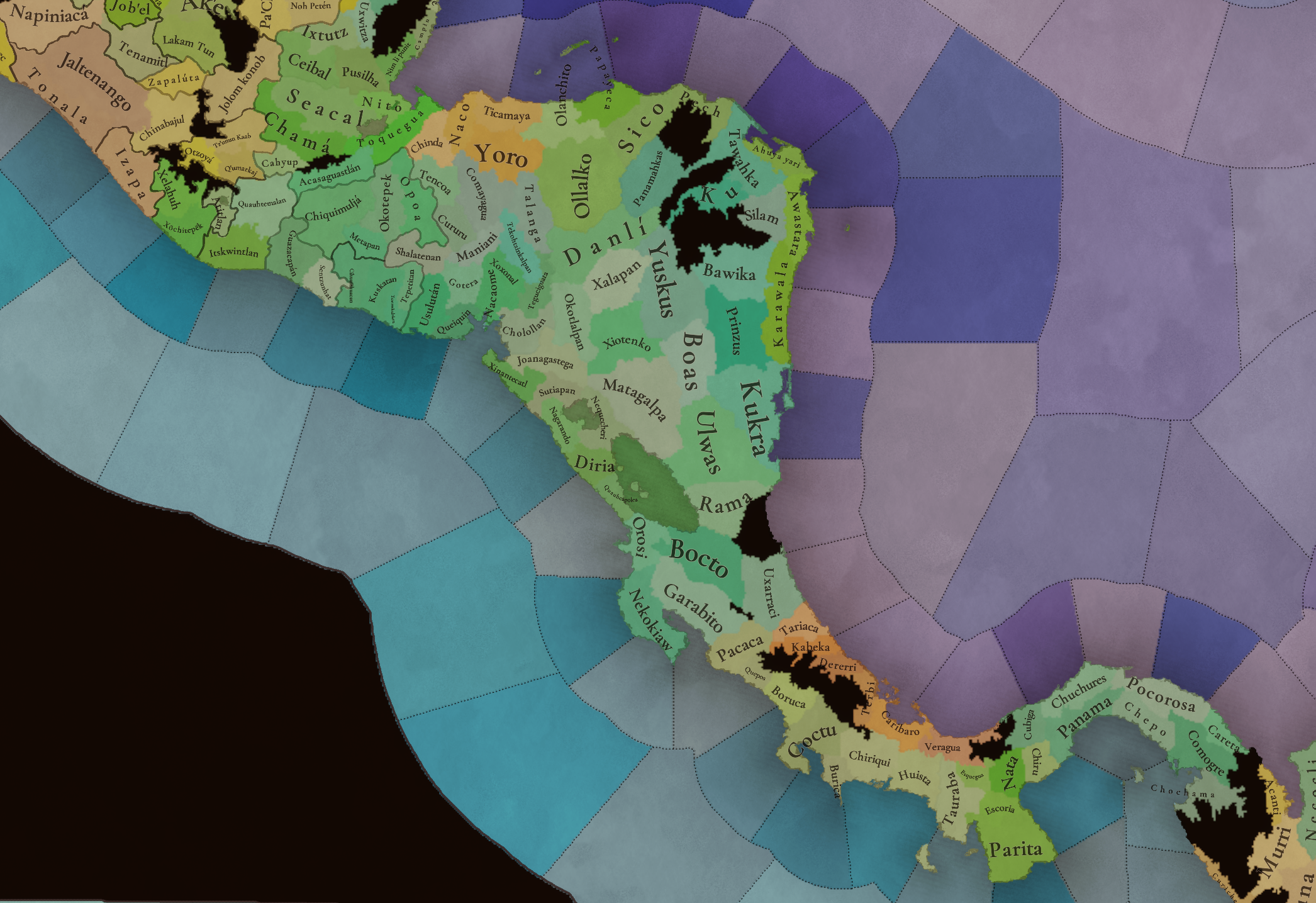
On the outskirts of the Mesoamerican polities, there are plenty of peoples organized on different ways. To the north, we have the ones that populate the area known as Aridoamerica, which were collectively termed by the Nahua as ‘Chichimeca’. We also have plenty of societies close to the Mayan lands and the Isthmus. And, finally, the Taíno people populate some of the biggest islands in the Caribbean.

Locations
Locations1.png

Locations2.png

Locations3.png

Locations4.png

Locations5.png

Locations6.png

Locations7.png

Locations8.png

Plenty of locations here! I just want no note that the Darien Gap is an impassable wasteland, which means that any army trying to cross from modern Panama and Colombia will need transport ships to be able to do it.

Provinces
Provinces1.png

Provinces2.png


Areas
Areas1.png

Areas2.png


Terrain
Climate.png

Climate2.png

Topography.png

Vegetation.png

Vegetation2.png

A very diverse region! Most of it is covered by Tropical Jungles and Forests, but Sierra Madre Occidental and Oriental make for very specific conditions in the Mexican Altiplano, which are not only visible in the Topography map but also in the climate and vegetation of the area.

Development
Development2.png

The most developed regions in Mesoamerica are the Valley of Mexico and the Mayan coastline.

Natural Harbors
Harbors.png

There are some good ports in the Caribbean, no surprise that most of them would later become important cities in the Colonial Period.

Culture
Cultures.png

Cultures2.png

Tons of cultures!

Language
Dominant Languages1.png

Dominant Languages2.png

Court Language.png

And also languages! The first two maps are the Dominant Languages per location, while the third is the Court Languages one. The dark blue language is ‘Totozoquean’, as it is not so easily readable (something we have to change).

Religions
Religions.png

This map is today in a more advanced state, as we have merged plenty of cultural religions into regional groupings. Of these, Tonalism, Nahua, and Mayan are part of the Tonalist religious groups, while the others are part of the Folk American group (a regional split of the former ‘Animist’ group). Nahua and Mayan have their different mechanics, which we’ll talk about in future Tinto Talks. Let us know what do you think of this design and any suggestions about the religious grouping!

Raw Materials
Raw Materials1.png

Raw Materials2.png

Raw Materials3.png

Raw Materials4.png

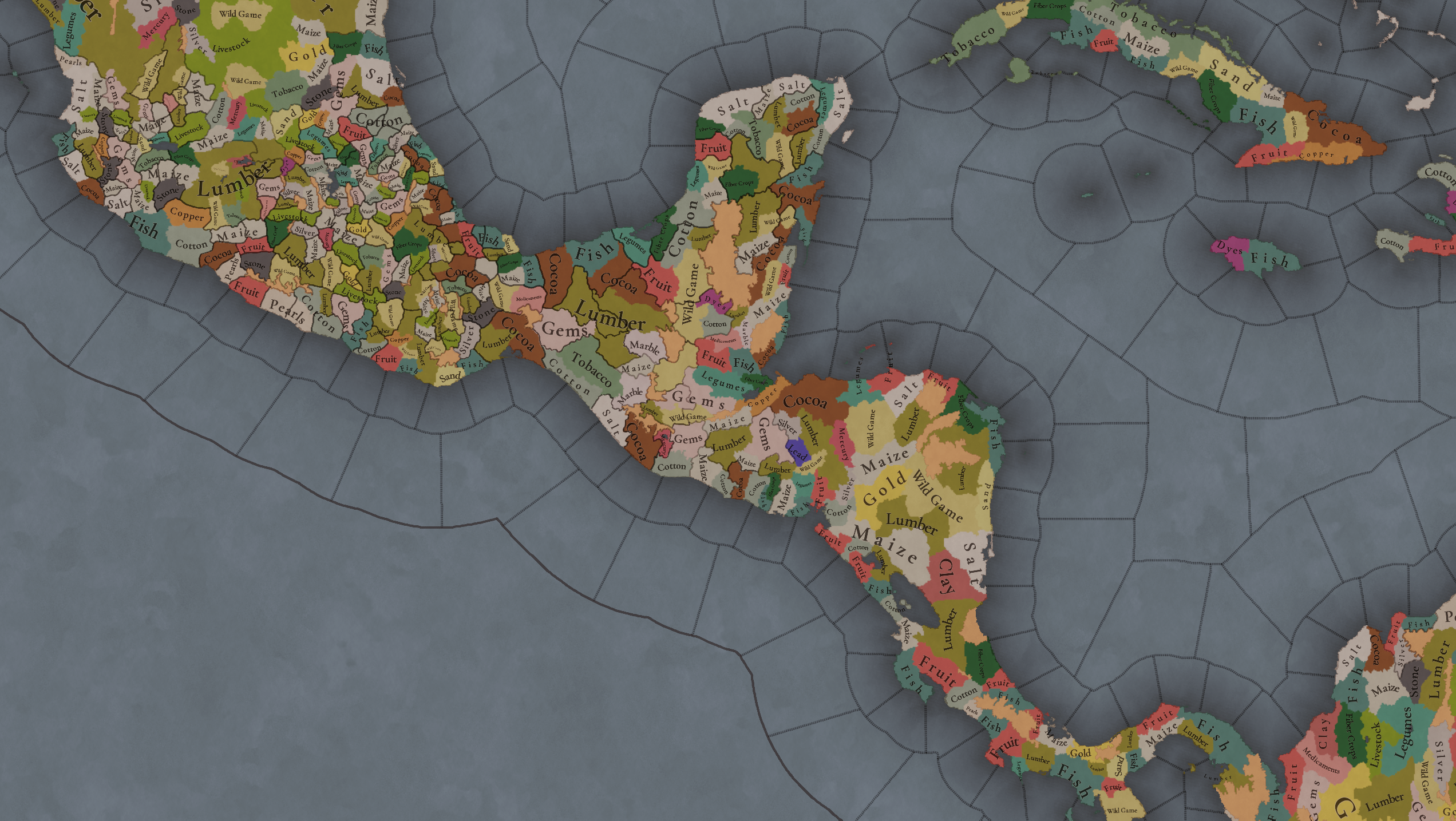
Maize is king in Mesoamerica, although there are plenty of other resources, including juicy Gold and Silver. Obsidian is not a separate resource, as it’s too regional-specific, so it’s included under the Gem coverage, but we have ways to represent it in-game; for instance, there’s a production method to produce Weaponry using Gems as an input.

Markets
Markets.png

A couple of bugs were reported while taking the screenshot of this map! But well, you can see that Azcapotzalco, Màayapáan, and Noh Petén (capital of the Itza people) are the most important ones.

Population
Population1.png

Population2.png

Population3.png

Population4.png

Population5.png

Population6.png

Population7.png

We have solved a couple of issues with the pop editor, and this week this map is in a decent state to be shown! Yay! Total numbers in the region are roughly 8.6M pops, distributed this way:
  • 523K in Aridoamerica (includes the lands to the North-West of the Purepecha Empire)
  • 6.947M in Mesoamerica (including North-Western Mayan lands)
  • 1.003M in Central America (including South-Eastern Mayan lands)
  • 151K in the Caribbean Islands

And that’s all for today! We hope you enjoyed these meaty maps! Next week we will be taking a look at the Levant Feedback, on Monday 16th, and South America, on Friday 20th! Cheers!
 
  • 117Like
  • 95Love
  • 5
  • 1
Reactions:
Before anything I want to recognize and thank Tinto team for all the work they are putting in this region (and the whole map). In particular I love to see a location density beyond what I was expecting to be represented on game.

Now of course there are a lot of things I want to talk about, I guess this will take many days more.
To start I want to share my own conservative suggestion (conservative not because Mesoamerica didnt deserve more detail, but beacuse it mean to be an initial approach) for the region. I hope it wont be detected as spam since I just posted it yesterday in another thread.
Mexico ver 02.png
Then from the real PC's Mesoamericas map we can start working with the official vision for the region. So I will start with some of the more evident things that I would like to be improved from the official map:
  • Break the Purepecha land into separated entities to represent the rise of the great Uacúsecha.
  • The "Nahua" religion of the Aztecs (broader proper meaning) and the "Tonalist" of the Zapotecs were closer to each other than any of these to the Purepecha religious traditions and divinities.
  • Tabasco, Chiapas and Guatemala definitely need some more detail, for example the lack of Soctones (Chiapanec), Mixe, Poqoman and the diminished Zoque are notorious absences.
  • Nayarit, northen Jalisco and southern Zacatecas could get a few more locations and SoP. By the way since PC have Culture and Language as separated elements it must be noted that the Occidente region was common to have the use of a "mexicano corrupto" by the elites and a variety of others utoaztecan (mostly/likely) groups. So this could be represented by the Nahuatl being the court language but most of the population being from different local cultures.
  • San Blas in Nayarit was a relevant port in the rute to Asia.
  • The lakes historical Magdalena/Etzatlán, Tlahualilo, Mayrán and Viesca could be added.
Many and more detailed suggestion to come in the next days!
 
Last edited:
  • 17Like
  • 4Love
  • 1
  • 1
Reactions:
Question: will the Aztecs (or Mexica, if they're given their historical name) be able to sacrifice the king/queen of Spain, sort of like "Impale the Sultan" for Wallachia in EU4?
 
  • 3Like
  • 3Haha
  • 2Love
Reactions:
I like the look of Mesoamerica. However, I'd like to point out something that I pointed out in the last Tinto Maps, which is the MASSIVE difference in the size of locations between areas west of the Appalachians and the portions east of it. This difference is only further magnified by the tiny locations in Mesoamerica, particularly when looking at the natural harbor mapmode and comparing modern-day Houston & San Diego to the port of Veracruz. The Houston location appears to be at least 10x larger than Veracruz, and San Diego possibly being 20x larger. This fact makes the map look a bit silly imo. As such, I think the locations in western NA could use a trim to be a bit more consistent in size with Mesoamerica and eastern NA.

Screenshot_20241213_215601_Chrome.jpg
 
  • 8Like
  • 1
  • 1
  • 1
Reactions:
I think the Otomanguean and Nuu Savi cultures should be broken down into smaller pieces. Otomanguean seems to include "miscellaneous" languages of the Otomanguean family from two separate branches, which split apart at least 5000 years ago; many of them are not at all related to each other. Similarly, Nuu Savi includes at least three different branches. I think a better arrangement would eb something like this:
View attachment 1230612
Xi'oi includes two somewhat closely related languages whose speakers lived similar livestyles in similar environments and went on to have similar history; I put them together for convenience.
Not much is known about the Otomanguean speakers in the west (at least to me); I lumped them with Otomi because that's my best guess.
Mazahua is an optional culture; it's probably fine to leave as part of Otomi unless you want to get really granular.
Popoloca (including three closely related languages) and Chinantec has been split off from Nuu Savi (Mixtec); if anything, they're more closely related to other branches of the family.
The last bit of Otomanguean is Amuzgo; it's a distant relative of Mixtec, so if it's too small to be its own culture, then it should probably be part of Nuu Savi.

With the cultural borders rearranged, a small portion of Nuu Savi land is actually part of a different language family; this is Mixe and I marked it in a different color.
The Tlahuica is another group from the area around the state of Morelos that like the Matlatzinca were struggling against the Nahua expansion. They should be in also.
 
  • 3
Reactions:
Is EU5 going to model the extremely severe effects that European disease had on the New World population? By some estimates these various diseases eventually killed off 90% of the entire native population in the New World. This obviously made conquering it much easier.

I would also like to see a better modeling of the many wars of resistance that native nations waged in the Americas against the Europeans. Some of them were well coordinated and consisted of broad alliances. Though they had some success they ultimately failed.


  • 3Like
Reactions:
Great job! I have two suggestions:

1. The locations of Baoruco and especially Ciguayo on Hispaniola should be split up. The sizes themselves are not too bad, but the shapes or rather the "reach" should really be remade. It really makes no sense to have Ciguayo, a coastal location, reach halfway across the island, even beyond the Cordillera central when there are inland locations on both sides of the mountains.

2. Tenochtitlan should be made a island location, and lake Texicoco a one-tile sea location.
 
  • 6
  • 1
Reactions:
Ok, so there's lots of very strange decisions in this area. I'm going to go broadly state by state in various posts, and I don't have information about every state. So, starting with Sinaloa, the Sierra Madre Occidental seems placed too far east to me.
sinaloa-state-of-mexico-colored-elevation-map-with-lakes-and-rivers-corner-auxiliary-location-...jpg

The highest peaks of the range are actually fairly close to the border with Durango, and the coastal strip is actually quite narrow, though this coastal strip is among the most fertile regions in the whole of Mexico, growing 25% of the country's grain despite Sinaloa only having 2.9% of the country's land.

I am firmly of the belief that the Tahues qualify as a settled country. They had a hereditary leader in Culiacán with authority over numerous (though admittedly not all) Tahue settlements, had monopoly of violence, and was able to concentrate both political and economic power. Comparing them with the less organised Totorames to their south is wrong. Comparing them to the pre-agricultural Guasaves to their northwest is even insulting.

The choice to separate out the Mayos and Yaquis from the Cahita is really strange, I cannot understand at all why this decision has been made. The Yaqui controlled a small area around the mouth of the Río Yaqui. See the cross-hatched area on the below map? It wouldn't have been more than this. Their territory actually expanded after colonisation:
Mario-Map.jpg

As to the Mayo, they controlled an area between the Río Mayo and the Río Fuerte. You've given them that but also a vast section of territory inland. I can't find a good map myself, but the area they controlled would be a little like this:
Mayo.png

You've also given the Mayo about half of the Guasave traditional territory, who are considered effectively universally to have controlled land around the mouth of the Río Fuerte. Here's a map. Most serious sources use something similar to this:
Sinaloa_prehispánica.jpg

It follows therefore that the positioning of the Guasaves, who were so primitive I'm a little surprised to see them on the map, is erroneous, since effectively all of the inland territory which you've given them was Cahita. I also note on the religious map the utterly inexplicable decision to have a 'Cahita religion' stretching as far north as Arizona. The Cahitas were a small tribal coalition in Northern Sinaloa and Southern Sonora. The Yaqui were the northernmost part of their nation, which consisted of Sinaloa, Ocoroni, Zuaque, Tehueco, Mayo, and Yaqui.

The south of the state is much better, though I do believe that the Acaxees and Xiximes should come a little further west to reflect that it really was a quite thin (but very fertile) coastal strip controlled by the Tahues and Totorames. Achires, incidentally, were much like the Guasaves. Very small, very primitive hunter-gatherers. I don't see a compelling reason to add them but they existed.

May as well move on to Durango.

Durango is hard, because the region changed significantly around the middle of the 14th century with the collapse of the (highly advanced) Chalchihuita culture, which was likely Zacateco, but could plausibly have been Tepehuán or Cora or something else. Here's a map from the 1500s, which is the earliest we have clear written sources for, but which is after an acknowledged period of significant social and ethnic change:
1734167623709.png

Here's what Breve Historia de Durango from José de la Cruz Pacheco Rojas says about the Chalchihuitas. I'm not going to translate because you speak Spanish and translation is a specific skill which I lack:

A la tradición anterior [Prechalchihuita] le sucede la cultura chalchihuita, que va de la fundación de Alta Vista, en el año 500, al año 1400 d.C. Es considerada como una prolongación hacia el norte de las altas culturas del periodo Clásico mesoamericano, que influyó sobre los pueblos asentados en los valles de la vertiente oriental de la Sierra Madre, en territorio zacatecano y duranguense, hasta momentos previos al contacto español.

La cultura chalchihuita se divide en dos ramas: la suchilteca y la guadiana. La primera vertió su influencia a partir de la fundación del centro astronómico de Alta Vista, en el Valle de Súchil, en territorio duranguense, donde se encontraban los fértiles valles que garantizaban el sustento y los yacimientos del apreciado chalchihuitl, la piedra verde que codiciaban todos los pueblos de Mesoamérica y el suroeste de Norteamérica. Tres aspectos sobresalen en la organización social de la cultura chalchihuita: la explotación minera, con el establecimiento de rutas de intercambio y comercio de sus productos; una definición clara en el uso astronómico de su principal centro ceremonial, Alta Vista, y su influencia en el modelo arquitectónico de las construcciones de uso ceremonial en forma de pirámide. Además, si tomamos en cuenta que los chalchihuitas eran alfareros especializados, comprenderemos por qué esta sociedad desempeñó un papel relevante durante el Clásico en la frontera septentrional de Mesoamérica.

La rama guadiana, por su parte, caracterizada por la marcada influencia en la cerámica, los modelos de asentamiento y la arquitectura ceremonial, comprende los años 600 a 1350 d.C. ...

Entre los sitios arqueológicos del Valle de Guadiana destaca La Ferrería, que presenta obras arquitectónicas y ceremoniales más complejas. Otros sitios con desarrollo paralelo al anterior fueron Navacoyan, Canatlán, El Molino, Hervideros, Tepehuanes y El Zape, con los cuales la influencia chalchihuita alcanzó el norte del territorio duranguense hasta encontrarse con el área de influencia de la cultura Loma San Gabriel

Cuando la cultura empezada a declinar y las aldeas se vieron en peligro de ser abandonadas, la región recibió un vigoroso impulso de las culturas de occidente. A finales del periodo Clásico (de 1000 a 1200 d.C.) la cultura duranguense inicia relaciones con la cultura Aztatlán, de la costa del Pacífico. A partir de ese momento se emprendió un intenso intercambio cultural que hizo posible la presencia de influencias vivificantes para los pueblos del Altiplano, las cuales harían posible su desarrollo hasta principios del siglo XV.

Finalmente, a lo largo de la vertiente occidental de la Sierra Madre, en la región de las Quebradas, se desarrolló una serie de expresiones culturales estrechamente vinculadas a la cultura Anazasi, del suroeste estadounidense, cuyos miembros habitaban, sobre todo, abrigos recosos al borde de las cañadas. Una de sus características sobresalientes fue la construcción de casas y graneros de piedra, adobe y madera. La organización de las actividades económicas era con toda seguridad compleja, pues suponía el aprovechamiento integral de los pisos ecológicos integrados a las cañadas y el paso del clima cálido al frío, lo que significada la práctica tanto de la caza como de la recolección y la agricultura. La estructura social era, en consecuencia, compleja.


On your map, of course, this sophisticated settled urban civilisation is a black hole with neither societies of pops or settled countries. I do get that it's hard when you don't know specifically what culture a place belongs to, but iirc you did include the Dorset culture, and the current implementation is somewhat of a joke.

Speaking of jokes, the religious map is severely in need of work. You've carried over the meme-y EU4 map, including random Mayas in the north because of the people of that region having split from the rest of the Maya three and a half thousand years before game start, and long before there was anything recognisable as then current Mayan religious practices. The split between 'Nahua' and 'Maya' religions itself had absolutely no basis whatsoever in the actual religious practices of the region, and just ended up being an excuse to turn every non-Mayan country into a clone of the Aztecs, complete with Aztec personal names and titles, whilst the 'Mayan' religion was a far better fit for every non-Aztec Mesoamerican country.

Xochiyaoyotl were in reality specific to the Aztec Triple Alliance, justified religiously by the unique Aztec fixation on obtaining large numbers of human sacrifices (other Mesoamericans had human sacrifice, but nowhere near to the same extent), and politically by a desire to restore the Toltec Empire. The Aztecs were even considered severely weird by other Nahua. There's an account in La Vida Cotidiana de los Aztecas en Vísperas de la Conquista of recently arrived Aztecs in the region meeting with another group of Nahua, and requesting one of their princesses. The other Nahua group complied, thinking this a political marriage, and were horrified when the Aztecs later sacrificed her and one of their priests met with them wearing her skin.

The book proposes the theory that the decision by the founders of Tenochtitlán to set up their capital in the middle of what was effectively a swamp, and required significant work over generations in the construction of chinampas etc to make it liveable, had perhaps less to do with religious prophecies about eagles eating snakes, and more to do with much more mundane defensive considerations, given that all of their neighbours hated them. The fact that the EU4 religious setup has been largely carried over to Project Caesar, with only the minor addition of a 'Tonalist' religion, is not encouraging. This was a highly religiously diverse region, though also one in which certain religious motifs were shared. None of the current religious lines make any real sense.

I do, of course, appreciate that records are spotty for many regions. In Oaxaca for example most of our information about local religious customs come from the Franciscans, who are at best vague about what they were seeing, but who record that there were various returns to a sort of 'ancestor worship cult' by the natives in the area, Mixtec, Zapotec, and Mixe. This is something where actual research is required, not memes and having unrelated peoples, including in EU4 the Otomí, worrying about a doomsday clock if they didn't sacrifice enough people. Surely to goodness you can do better than that.

I might create more posts about different regions, I have quite a lot of books about Mexico, but it's somewhat demotivating when I'm starting from this, especially in circumstances where you even use the outright pejorative 'Africa begins at the Pyrenees' term of 'Central America' to include Mexico and the Caribbean (not just Central America), rather than a neutral geographical term like 'Middle America'. Tell us how you don't think that Mexicans are just sudacas.
 
  • 15Like
  • 6
  • 2
  • 1Love
Reactions:
I think giving Tenochtitlan a conditional Siege defence bonus would portray it's island position best without having to make the island a wholly separate location.

Let's say you give the location a +xx% local defensiveness or a +xx% number of besieging troops required and a bonus to allied troops' combat ability on the location, and besieging countries that have a certain naval technology/advance unlocked already get to circumvent this defensiveness, or get a reduced penalty. That way you could portray the Spanish conquest of Tenochtitlan while giving the city an edge against the other local states.
 
  • 2Like
  • 2
Reactions:
I am of the opinion that there is nothing wrong with artificially enlarging certain islands like tenochtitlan or venice. Geographic accuracy is good, but paradox games should care more about historically accuracy. These island-cities being larger would allow for more of the later, as it would allow them to be their own specific locations, and such better represent their historical advantages.
 
  • 12
  • 3Like
Reactions:
I am of the opinion that there is nothing wrong with artificially enlarging certain islands like tenochtitlan or venice. Geographic accuracy is good, but paradox games should care more about historically accuracy. These island-cities being larger would allow for more of the later, as it would allow them to be their own specific locations, and such better represent their historical advantages.
They don't even necessarily have to be physically larger, only their hitboxes do because they can extend into the ocean to make them easier to click. For gameplay and historical accuracy, both Tenochtitlan and Venice should be islands with a straight crossing, able to be controlled through both the navy but assailable by an army alone if no naval superiority is had by either side, albeit with a straight crossing penalty.
 
  • 6
  • 2Like
  • 1
Reactions:
The culture map looks great.
 
Regarding language: This is apparently the map of Dominat language in Mesoamerica
1734174903299.png

With the various cultures.
1734175031062.png


Given the fact that the Totozoquean languages are not even recognized as a valid, only a proposed language grouping I suggest there needs to be a substantial rework of the whole language set of the region. The languages were supposed to represent mutually intelligible linguistic clusters, such as West Slavic or Spanish or French. Not hypothetical linguistic families that are not even valid linguistic groupings.

MY PROPOSAL

MAYAN LANGUAGES
  • Huastec language - most divergent branch, Teenek culture)
  • Yucatec language- second most divergent branch, to include Maaya cultre, Mopan and Itza
  • the rest I suggest divide the rest into a western Maya and an eastern Maya branch
MIXE-ZOQUEN
  • Mixe language (Mixe, to be shown on the map from the southeastern sections of the Ňuu Sayi area, also please add "Tapachultec culture" from the coastal areas of the Mam culture area)
  • Zoque language (please check location here and here and here and here. Please add Chiapas Zoque from the "Sotzleb" and "Winik Atel" culture areas)
OTO-MANGUEAN LANGUAGES
The Oto-Manguean language family is the most diverse and most geographically widespread language family represented in Mesoamerica. The internal diversity is comparable with that of Indo-European, and the Proto-Oto-Manguean language is estimated to have been spoken some time before 2000 BCE.[1] This means that at least for the past 4000 years Oto-Manguean languages have coexisted with the other languages of Mesoamerica and have developed many traits in common with these, to such an extent that they are seen as part of a sprachbund called the Mesoamerican Linguistic Area.
As such, I suggest every branch be its own "language" in game terms.
  • Amuzgoan language (Amuzgo culture (native name "Tzjon Noan"
  • Chiapatec language (located at Napiniaca location)
  • Chinantec languages ( Chinantec culture, nativee to southern Tuxtepec district)
  • Mazatec language (Mazatec culture, not yet presen, native to northern northern Tuxtepec district)
  • Matlatzinga language - conterminious of the same culture
  • Mangue languge (Chorotega culture)
  • Mixtecan language (Ňuu Savi culture, Trique --not sure if it is on the map, please add)
  • Otomí language - to be most of so-called "Otomanguean culture"
  • Pamé language - Pamé culture to be added
  • Tlapanec language (Me´phaa culture+ Subtiaba in Nicaragua, not present on map)
  • Zapotec language (Zapochteca culture, also please add "Chatino culture" on the locations of "Juchatengo", "Tototepec" and "Manialtepec"

TOTONACAN LANGUAGES
  • Totonacan language (Tutunakí)
  • Tepehuan language (majority: Tutotepec location, minority: Huayacocotla location)
1734181858078.png
 
  • 10Like
  • 3
  • 1
Reactions:
Here are a few suggestions on changes:
1734155226723.png
1734156108578.png
1734157588793.png


  • Zaachila shouldn't be comprised of two enclaves:
    • Etla province should be Sosola, while Sosola province should be Yodzocahi and be an independent state of Yodzocahi.
    • Yucunudabui should be Yucundeq and belong to Yodzocoo, while the eastern enclave of Yodzocoo should be an independent Cuicatlan.
    • Ixtlan should be an independent state.
    • Yucundaa should be independent Teposcocula
    • Nochixtlan, Jaltepec, Teozacualco should be Chiocano.
    • Sola should be Coatlan, while Coatlan should be Comitlan. Sola (Coatlan) should belong to the state of Quiegoqui.
    • Tlacolula should belong to Zaachila
    • All locations of Zaachila north of Yucucui should be Mixtec culture instead of Zapotec.
  • Pochutec should be a separate culture from Nahua, they are distinctive in the same way as Pipil from Nahua.
  • Zapotec, Mixtec and Popolocan should speak Eastern Otomanguean instead of Totozoquean.
  • Ikoot culture (Huave) should be moved to the east. West of lagoon should be majority Zapotec with Ikoot minorities.

1734259776058.png

Here is a culture map of an area (Nuu Savi marked Mixtec for convenience)

This state of Me'phaa is also not accurate and is named after an endonym. Each location here should be its own state, while Yopitzinco and Tixtla should have Nahua minorities, known as Nahua-Coixca.
1734167106786.png


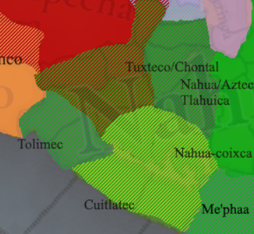
West of it, Zacatula should be Zacatollan. Zacatollan and Ixtapa should be Tolimec culture with Nahua minority. Tecpan, Tetellan, and Cihuatlan should be Cuitlatec culture with Nahua minority. Citzamala and Ajuchitlan should be Purepecha culture with Nahua minority. Probably all of them should have Nahua as court language, either way, all of them were mixed.

1734331214012.png


I also recommend adding two wastelands south of Metztitlan. It was important part of Metztitlan defensive advantage over Aztecs.
1734171531875.png

In Xalisco, Tepic location should be divided into Xalisco in south and Sentispac to the north. While Sentispac renamed to Aztatlan. Santa Maria Oro should be renamed to Tzapotzingo or Chimaltitlan. Xalisco should probably be 1 province-state

1734172618133.png
1734172663366.png

Also, Xalisco should not be Nahua, they are Wixarika/Huicholes people, same for Amecas and Coras here is reference map:
1734202989402.png

The area north of Xalisco, should be of Coras culture in the city of Aztatlan.
Speaking of divisions of Nahua, it doesn't make sense to separate Teco and Tlaxcaltec if you are not gonna separate Pochutec. Either don't separate Teco and Tlaxcaltec from Nahua or make something like this:
1734214007600.png

Eastern Nahua were named Olmecs by Aztecs and later this name was adopted for Old Olmecs. Tlahuica and Aztec division may be excessive, after all people of the central Nahua area were called Aztecs. Additionally, the Otomi population near Xalisco-Teco region should be mixed with Nahuatl.
Amecas, Coras and Huichol are not Nahua, however, they are Wixarikas.
Now, the Totonac area should be something like this. There was no Cempoallan enclave:

1734174860958.png


Part around Chiapas is also wrong. First, two Tonala provinces. Also, many misplaced cultures, including Ikoot, previously mentioned, Coatzacualco is Nahua settlement. Coatlicamac and Tehuantepec are Zapotec settlements.

1734175872800.png
1734183724490.png

Here are all my proposed changes to this region including ellimination of all enclaves:

1734203744382.png

I marked a few tributary areas, tributaries should possibly be either vassals or directly ruled by the main city-state.

Map corrections by nyetflix2:
  • Ajuchitlan and Cutzamala should be Cuitlatec majority. Ajuchitlan in particular was the main Cuitlatec town.
  • the Chontal culture which should be the majority in Tlachco, Teloloapan and Tepecoacuilco.
  • Saqulew/Zaculeu is in the wrong place. It was where the Otzoya location is now, very close to modern Huehuetenango.
  • Izquintepec/Itskwintlan was a Pipil settlement, not Kaqchikel.
  • the Xinca should be SOP.
  • Izalco and Apaneca should be vassals under Kuskatan.
  • Metapan should be Mitlan and moved to the west.
  • Copilco should have both Zoque/Popoluca and Nahua minorities. Xicallango should also have a Nahua minority.
  • Chimalapa and Coatlicamac should be the Zapotec ruling class and Mixe-Zoque population.
  • Chocohuitl should be Tapachultec.
  • There's also a bunch of small unclassified cultures in Jalisco that were distinct from Nahua. These would cover the locations of Sayula, Tlamazollan, Tochpan, Amollan, and Tlayolan. This wiki article mentions them. Xilotlan, Coahuayana and Pomaro were inhabited by the Xilotlantzinca, I've seen them described as Nahuas but I'm unsure about it.
 
Last edited:
  • 13Like
  • 5Love
  • 3
Reactions:
Here are a few suggestions on changes:
View attachment 1230717View attachment 1230719View attachment 1230761

  • Zaachila shouldn't be comprised of two enclaves:
    • Etla province should be Sosola, while Sosola province should be Yodzocahi and be an independent state of Yodzocahi.
    • Yucunudabui should be Yucundeq and belong to Yodzocoo, while the eastern enclave of Yodzocoo should be an independent Cuicatlan.
    • Ixtlan should be an independent state.
    • Yucundaa should be independent Teposcocula
    • Nochixtlan, Jaltepec, Teozacualco should be Chiocano.
    • Sola should be Coatlan, while Coatlan should be Comitlan. Sola (Coatlan) should belong to the state of Quiegoqui.
    • Tlacolula should belong to Zaachila
    • All locations of Zaachila north of Yucucui should be Mixtec culture instead of Zapotec.
  • Pochutec should be a separate culture from Nahua, they are distinctive in the same way as Pipil from Nahua.
  • Ikoot culture (Huave) should be moved to the east. West of lagoon is populated by Zapotec.

View attachment 1230810
Here is culture map of an area (Nuu Savi marked Mixtec for convenience)

This state of Me'phaa also is not right and named after endonym. Each location here should be it's own state, while Yopitzinco should have Nahua minorities.
View attachment 1230811

West of it, Zacatula should be Zacatollan. Zacatollan and Ixtapa should be Tolimec culture with Nahua minority. Tecpan, Tetellan and Cihuatlan should be Cuitlatec culture with Nahua minority. Citzamala and Ajuchitlan should be Purepecha culture with Nahua minority. Either way, all of them were mixed.

View attachment 1230824

Going to Nahuas, I recomment adding two wastelands south of Metztitlan. It was important part of Metztitlan defensive advantage over Aztecs.
View attachment 1230837
In Xalisco, Tepic location should be divided into Xalisco in south and Sentispac to the north. While Sentispac relamed ti Aztatlan. Santa maria oro renamed to Tzapotzingo or Chimaltitlan.

View attachment 1230841View attachment 1230842
Speaking of divisions of Nahua, it doesn't make sense to separate Tlaxcaltec if you are not gonna separate Pochutec. Either don't separate Tlaxcaltec from Nahua or make something like this:
View attachment 1230869
Now, Totonac area should be something like this. There was no Cempoallan enclave

View attachment 1230876

Part around Chiapas is also wrong. First, two Tonala provinces. Also, many misplaced cultures, including Ikoot, previously mentioned, Coatzacualco is Nahua settlement. Coatlicamac and Tehuantepec are Zapotec settlements.

View attachment 1230895View attachment 1230940
Here are all my proposed changes to this region including elimination of all enclaves:
View attachment 1230939
Wow, amazing.
Though you may have missed the Tapachultec language that used to be spoken on the coast of Chiapas.
The Mixe and Zoque cultures should really be reworked.
I failed to find what the "Ikoot" culture stands for
 
  • 1Like
Reactions:
Wow, amazing.
Though you may have missed the Tapachultec language that used to be spoken on the coast of Chiapas.
The Mixe and Zoque cultures should really be reworked.
I failed to find what the "Ikoot" culture stands for
Thank you, you are right, a few coastal cities I placed as Mam should actually be Tapachultec. I kinda missed going in-depth for Mixe-Zoque
Ikoot is Huave, a language isolate, they are original inhabitants of the Tehuantepec lagoon but were mostly assimilated by Zapotecs.
 
Last edited:
  • 3Like
Reactions:
With regards to the population figures, I think it would help if Tinto shared the sources/methodologies they used to pick their numbers. It would make it much easier for the community to give feedback/critique.
 
  • 5Like
Reactions: