• We have updated our Community Code of Conduct. Please read through the new rules for the forum that are an integral part of Paradox Interactive’s User Agreement.

Tinto Maps #29 - 13th of December 2024 - Central America

Hello everybody, and welcome to Tinto Maps, the happy Fridays for map lovers! Today, we will be looking at Central America, which includes the Caribbean. Before we start, I want to introduce you @RaulTrullenque , the only member of our Content Design team who had not yet gone public, and who worked really hard on the maps and content of the Central American and South American regions.

And now let’s get started without further ado!

Countries
Countries1.png

Countries2.png

Countries3.png

Countries4.png

Countries5.png

Countries6.png

Countries7.png

Tenochtitlan.png

Mayan.png
Welcome to the Mesoamerican Thunder Dome! This area is characterized by its numerous Altepetl, more or less comparable to city-states. Most of them are ruled in 1337 by peoples of Nahua origin, something that you may see much more clearly in the culture map. The biggest power in this moment is the Empire of P’urhépecherio, though, founded by the Purepecha people. In any case, you may notice that there’s a lot of detail in this area, including a tiny Nahua settlement recently founded on an island over Lake Texcoco, Tenochtitlan. This is the first time in a PDX GSG that we have the island itself present on the map, although the location covers some more land over the lake coast, to make it playable. Finally, we also have the Mayan polities of the Postclassic Period, of which Cocom, with its capital Màayapáan, was the most important, along with others, such as K’iche’ and its capital Q’umarkaj.

SoPs
SoPs1.png

SoPs2.png

SoPs3.png

SoPs4.png
On the outskirts of the Mesoamerican polities, there are plenty of peoples organized on different ways. To the north, we have the ones that populate the area known as Aridoamerica, which were collectively termed by the Nahua as ‘Chichimeca’. We also have plenty of societies close to the Mayan lands and the Isthmus. And, finally, the Taíno people populate some of the biggest islands in the Caribbean.

Locations
Locations1.png

Locations2.png

Locations3.png

Locations4.png

Locations5.png

Locations6.png

Locations7.png

Locations8.png

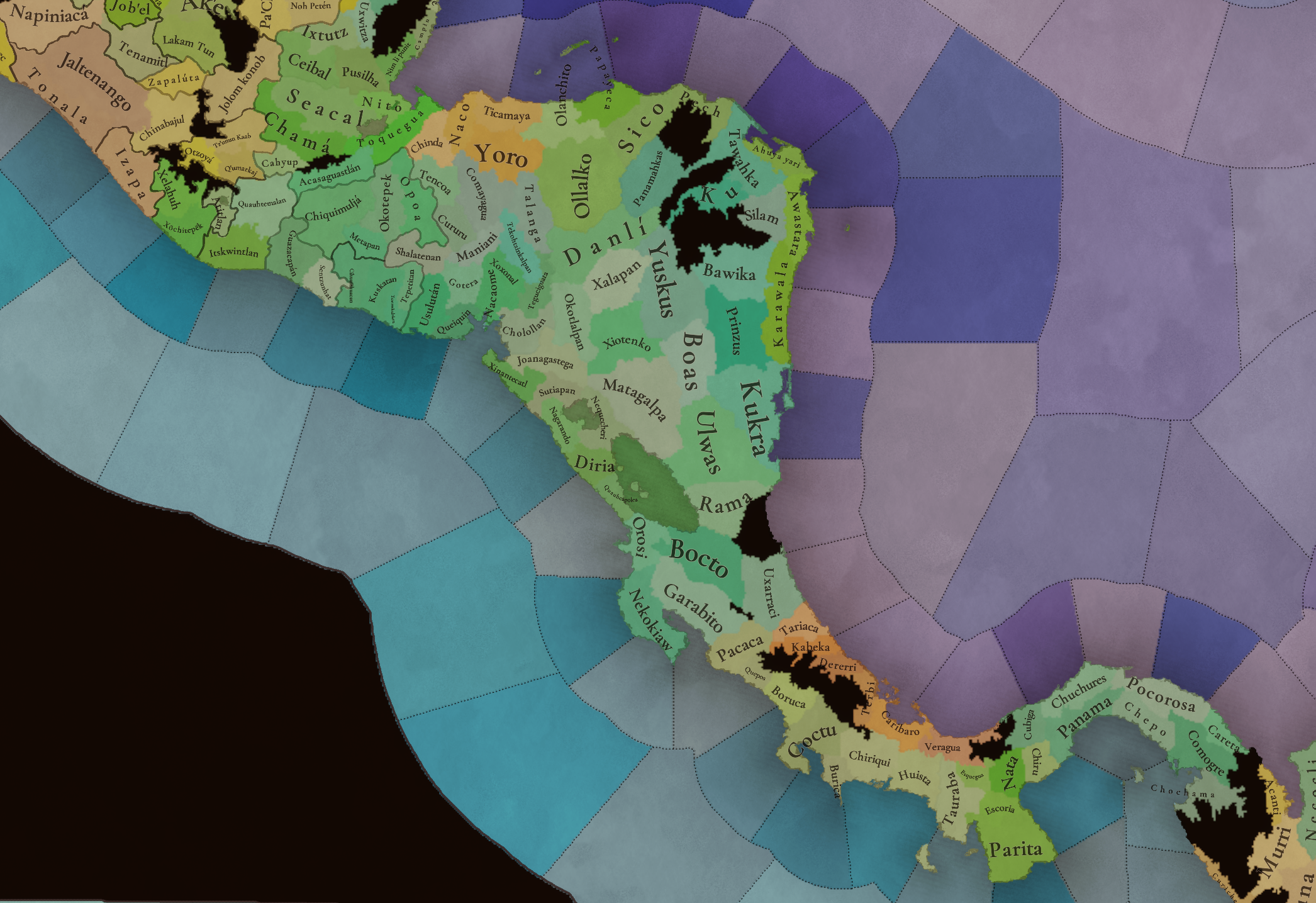
Plenty of locations here! I just want no note that the Darien Gap is an impassable wasteland, which means that any army trying to cross from modern Panama and Colombia will need transport ships to be able to do it.

Provinces
Provinces1.png

Provinces2.png


Areas
Areas1.png

Areas2.png


Terrain
Climate.png

Climate2.png

Topography.png

Vegetation.png

Vegetation2.png

A very diverse region! Most of it is covered by Tropical Jungles and Forests, but Sierra Madre Occidental and Oriental make for very specific conditions in the Mexican Altiplano, which are not only visible in the Topography map but also in the climate and vegetation of the area.

Development
Development2.png

The most developed regions in Mesoamerica are the Valley of Mexico and the Mayan coastline.

Natural Harbors
Harbors.png

There are some good ports in the Caribbean, no surprise that most of them would later become important cities in the Colonial Period.

Culture
Cultures.png

Cultures2.png

Tons of cultures!

Language
Dominant Languages1.png

Dominant Languages2.png

Court Language.png

And also languages! The first two maps are the Dominant Languages per location, while the third is the Court Languages one. The dark blue language is ‘Totozoquean’, as it is not so easily readable (something we have to change).

Religions
Religions.png

This map is today in a more advanced state, as we have merged plenty of cultural religions into regional groupings. Of these, Tonalism, Nahua, and Mayan are part of the Tonalist religious groups, while the others are part of the Folk American group (a regional split of the former ‘Animist’ group). Nahua and Mayan have their different mechanics, which we’ll talk about in future Tinto Talks. Let us know what do you think of this design and any suggestions about the religious grouping!

Raw Materials
Raw Materials1.png

Raw Materials2.png

Raw Materials3.png

Raw Materials4.png

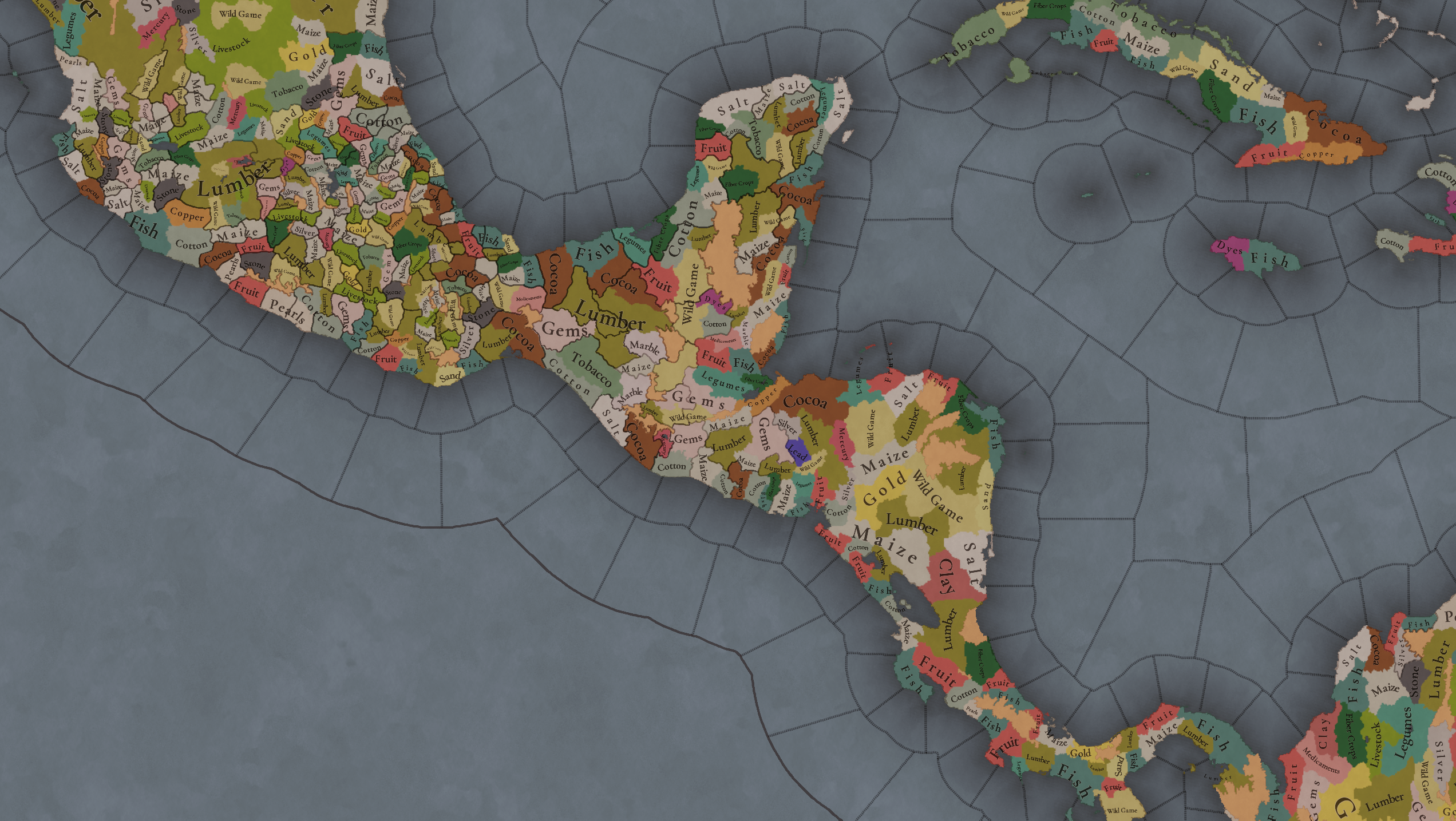
Maize is king in Mesoamerica, although there are plenty of other resources, including juicy Gold and Silver. Obsidian is not a separate resource, as it’s too regional-specific, so it’s included under the Gem coverage, but we have ways to represent it in-game; for instance, there’s a production method to produce Weaponry using Gems as an input.

Markets
Markets.png

A couple of bugs were reported while taking the screenshot of this map! But well, you can see that Azcapotzalco, Màayapáan, and Noh Petén (capital of the Itza people) are the most important ones.

Population
Population1.png

Population2.png

Population3.png

Population4.png

Population5.png

Population6.png

Population7.png

We have solved a couple of issues with the pop editor, and this week this map is in a decent state to be shown! Yay! Total numbers in the region are roughly 8.6M pops, distributed this way:
  • 523K in Aridoamerica (includes the lands to the North-West of the Purepecha Empire)
  • 6.947M in Mesoamerica (including North-Western Mayan lands)
  • 1.003M in Central America (including South-Eastern Mayan lands)
  • 151K in the Caribbean Islands

And that’s all for today! We hope you enjoyed these meaty maps! Next week we will be taking a look at the Levant Feedback, on Monday 16th, and South America, on Friday 20th! Cheers!
 
  • 117Like
  • 95Love
  • 5
  • 1
Reactions:
This reminds me of how worried I am that the game will totally fail to represent how remote regions with hostile climate and/or terrain should be effectively impassable to armies.

The issue here though, I honestly think, is that the game actually has a lot of impassable regions like this, which seem to mainly represent areas that aren't necessarily super hostile compared to other similar places, but historically were undeveloped during the game time period. The Darien Gap is just the most famous one, but you can see similar stuff in Siberia and Canada.

As such, I am going to argue in favour of Darien remaining impassable, since it being impassable aligns with the game design that if a region was not developed until after 1836 it should be impassable. This especially applies to Darien since it was developed never. Basically, I think the benefit of giving Darien a playble space is less important than the danger of making it passable (the game will potentially lose the ability to represent the effective real-life impassability that still exists even today). And besides, having land transport between North and South America blocked just makes the game more interesting, while still being historically accurate.
I think you have a great point here that until we get a Paradox game with a truly dynamic map, erring on the side of accuracy for the time period in comparison to plausible but ahistorical outcomes is better.
 
  • 2Like
Reactions:
Pls fix Croatia borders..bc there was still banate of slavonia
I dont give a fuck if you disagree its history if you dont know it its your problem Ban of Croatia was ban of Dalmatia and Slavonija..

The Banate of Slavonia (Croatian: Banovina Slavonija) was a historical administrative region that existed within the medieval Kingdom of Hungary and later the Kingdom of Croatia. It played a significant role in the governance and political structure of these regions.

Historical Context
Formation and Title: The title "Ban of Slavonia" was established in the 11th century, with Demetrius Zvonimir being one of the earliest notable figures to hold this title from around 1070 to 1075. Initially, there was a single ban for all of Croatia, but by the 13th century, Slavonia had its own distinct ban23.
Geographical Scope: The Banate encompassed areas that are part of modern-day eastern Croatia and northwestern Bosnia and Herzegovina. It included regions that were crucial for trade and agriculture, making it an important administrative division during its existence23.
Political Structure: The Banate functioned under the authority of the Hungarian crown, with bans acting as governors. They were considered among the "barons of the realm," enjoying various privileges associated with their office. Over time, the title evolved, and by the 14th century, it was often held by noble relatives of Hungarian monarchs23.

Evolution and Legacy
Integration into Larger Entities: The Banate of Slavonia existed until 1476 when it was merged with the titles of Ban of Croatia and Dalmatia. This integration reflected broader political changes within the region as it moved toward a more centralized governance structure under Hungarian influence24.
Cultural Impact: The historical significance of the Banate is reflected in its contributions to Croatian identity and governance. It served as a precursor to later administrative divisions in Croatia, including its role in the formation of modern political entities during the 19th and 20th centuries12.

In summary, the Banate of Slavonia was a key historical entity that shaped the political landscape of medieval Croatia and Hungary, influencing both governance structures and regional identities that persist today.
 
Last edited:
  • 14
  • 2Like
Reactions:
I dont give a fuck if you disagree its history if you dont know it its your problem Ban of Croatia was ban of Dalmatia and Slavonija..

The Banate of Slavonia (Croatian: Banovina Slavonija) was a historical administrative region that existed within the medieval Kingdom of Hungary and later the Kingdom of Croatia. It played a significant role in the governance and political structure of these regions.

Historical Context
Formation and Title: The title "Ban of Slavonia" was established in the 11th century, with Demetrius Zvonimir being one of the earliest notable figures to hold this title from around 1070 to 1075. Initially, there was a single ban for all of Croatia, but by the 13th century, Slavonia had its own distinct ban23.
Geographical Scope: The Banate encompassed areas that are part of modern-day eastern Croatia and northwestern Bosnia and Herzegovina. It included regions that were crucial for trade and agriculture, making it an important administrative division during its existence23.
Political Structure: The Banate functioned under the authority of the Hungarian crown, with bans acting as governors. They were considered among the "barons of the realm," enjoying various privileges associated with their office. Over time, the title evolved, and by the 14th century, it was often held by noble relatives of Hungarian monarchs23.

Evolution and Legacy
Integration into Larger Entities: The Banate of Slavonia existed until 1476 when it was merged with the titles of Ban of Croatia and Dalmatia. This integration reflected broader political changes within the region as it moved toward a more centralized governance structure under Hungarian influence24.
Cultural Impact: The historical significance of the Banate is reflected in its contributions to Croatian identity and governance. It served as a precursor to later administrative divisions in Croatia, including its role in the formation of modern political entities during the 19th and 20th centuries12.

In summary, the Banate of Slavonia was a key historical entity that shaped the political landscape of medieval Croatia and Hungary, influencing both governance structures and regional identities that persist today.
Finally people are recognizing the importance of the native American tribe of the Croats
 
  • 27Haha
Reactions:
I dont give a fuck if you disagree its history if you dont know it its your problem Ban of Croatia was ban of Dalmatia and Slavonija..

The Banate of Slavonia (Croatian: Banovina Slavonija) was a historical administrative region that existed within the medieval Kingdom of Hungary and later the Kingdom of Croatia. It played a significant role in the governance and political structure of these regions.

Historical Context
Formation and Title: The title "Ban of Slavonia" was established in the 11th century, with Demetrius Zvonimir being one of the earliest notable figures to hold this title from around 1070 to 1075. Initially, there was a single ban for all of Croatia, but by the 13th century, Slavonia had its own distinct ban23.
Geographical Scope: The Banate encompassed areas that are part of modern-day eastern Croatia and northwestern Bosnia and Herzegovina. It included regions that were crucial for trade and agriculture, making it an important administrative division during its existence23.
Political Structure: The Banate functioned under the authority of the Hungarian crown, with bans acting as governors. They were considered among the "barons of the realm," enjoying various privileges associated with their office. Over time, the title evolved, and by the 14th century, it was often held by noble relatives of Hungarian monarchs23.

Evolution and Legacy
Integration into Larger Entities: The Banate of Slavonia existed until 1476 when it was merged with the titles of Ban of Croatia and Dalmatia. This integration reflected broader political changes within the region as it moved toward a more centralized governance structure under Hungarian influence24.
Cultural Impact: The historical significance of the Banate is reflected in its contributions to Croatian identity and governance. It served as a precursor to later administrative divisions in Croatia, including its role in the formation of modern political entities during the 19th and 20th centuries12.

In summary, the Banate of Slavonia was a key historical entity that shaped the political landscape of medieval Croatia and Hungary, influencing both governance structures and regional identities that persist today.
Please post this in the Balkans review. People are disagreeing because this isn't about Central America.
 
  • 20Like
  • 5
Reactions:
Is there archeological evidence that the population grew 10-50 times in the period?
Maybe, but even outside the genetic evidence an estimate of 100k was perfectly valid and endorsed by recent scholars, not anegregious undercount, you posted the estimates yourself and there are a decent amount of estimates at or below 100k, and I would add to it "Livi-Bacci, M.. (2003). Return to Hispaniola: Reassessing a Demographic Catastrophe." which gives 100k to 400k, made recently in 2003.

While higher numbers are plausible if you do number crunching, both 50k and 100k fit within at least some of the non-genetic estimates and perfectly fit the genetic evidence and the way that the people that collected it interpreted it.
The traditional archaeological eras of the island help explain the population increase prior to European contact. In Compendio General Arqueológico de Santo Domingo, Elpidio Ortega outlines cultural horizons that highlight this demographic evolution (Translated from Spanish):

"The productive process begins to evolve depending on the production capacity of the indigenous groups. These groups rely on the technique of planting in agricultural mounds, generating various economies that surpass those produced by the slash-and-burn system. The phenomenon is as follows: Due to increased production, indigenous societies begin to gather, increasing the population to such an extent that by the 9th and 10th centuries of our era, the population of the island of Santo Domingo, eastern Cuba, and Puerto Rico increases considerably."
Ortega also presents a classification of cultural development on the island:
  1. Hunters and gatherers with specialized collection.
  2. Gatherers with initial agricultural production.
  3. Cultivators using slash-and-burn agriculture.
  4. Cultivators transitioning to grain cultivation (Veloz Maggiolo, 1976).
The fourth period, described as "the greatest development of the Taino cultural complex," spread from the eastern part of Hispaniola, with the "Bocachica" ceramic style predominating in the Greater Antilles. According to Ortega, this period began around the turn of the millennium, coinciding with a significant demographic expansion.

In Arqueología Prehistórica de Santo Domingo, Marcio Veloz Maggiolo elaborates on the ongoing debate about the island's pre-Columbian population:

"The demography of Hispaniola is, at present, a subject of debate regarding its indigenous population. While some authors, like Rosenblat, estimate no more than 120,000 individuals for the area of the island, and others, like Spinden, calculate the population from Puerto Rico to the eastern region of Cuba at one million, the archaeological record suggests otherwise. Dr. Emilio Cordero Michel considers that the population of Hispaniola fluctuated between 150,000 and 200,000 indigenous people—a figure that seems reasonable since, otherwise, the archaeological remains would have been far more numerous. Nevertheless, until a demographic study based on agricultural production, the extent of cultivated land, crop types and frequencies, and the proportion of diet derived from the sea and hunting is conducted, it will be very difficult to establish an acceptable demographic index."
The kind of study Maggiolo suggested was later performed by Massimo Livi Bacci in Return to Hispaniola: Reassessing a Demographic Catastrophe. Using economic, anthropological, and demographic methodologies, Livi Bacci refines the plausible population range:

"...a probability distribution places the most likely figure between 200,000 and 300,000, with levels below 100,000 and above 400,000 both unlikely."
This archaeological and anthropological evidence supports the idea of significant population growth in the centuries preceding European contact.


In any case, the game starts around 1337, while the population may not have reached 300,000, a figure of 150,000 is I believe a reasonable compromise—three times more than the current depiction of 50,420 on the maps presented on this Tinto Maps.
 
  • 2
Reactions:
The traditional archaeological eras of the island help explain the population increase prior to European contact. In Compendio General Arqueológico de Santo Domingo, Elpidio Ortega outlines cultural horizons that highlight this demographic evolution (Translated from Spanish):


Ortega also presents a classification of cultural development on the island:
  1. Hunters and gatherers with specialized collection.
  2. Gatherers with initial agricultural production.
  3. Cultivators using slash-and-burn agriculture.
  4. Cultivators transitioning to grain cultivation (Veloz Maggiolo, 1976).
The fourth period, described as "the greatest development of the Taino cultural complex," spread from the eastern part of Hispaniola, with the "Bocachica" ceramic style predominating in the Greater Antilles. According to Ortega, this period began around the turn of the millennium, coinciding with a significant demographic expansion.

In Arqueología Prehistórica de Santo Domingo, Marcio Veloz Maggiolo elaborates on the ongoing debate about the island's pre-Columbian population:


The kind of study Maggiolo suggested was later performed by Massimo Livi Bacci in Return to Hispaniola: Reassessing a Demographic Catastrophe. Using economic, anthropological, and demographic methodologies, Livi Bacci refines the plausible population range:


This archaeological and anthropological evidence supports the idea of significant population growth in the centuries preceding European contact.


In any case, the game starts around 1337, while the population may not have reached 300,000, a figure of 150,000 is I believe a reasonable compromise—three times more than the current depiction of 50,420 on the maps presented on this Tinto Maps.
"the archaeological record suggests otherwise. Dr. Emilio Cordero Michel considers that the population of Hispaniola fluctuated between 150,000 and 200,000 indigenous people"
Flucatuate in what period?
 
  • 1Like
Reactions:
PDX really needs to invest into a more dynamic map within the engine, rather than everything in the map being static during the game. But I can imagine that would be a lot of work and require extensive reworking of the engine, so sadly won’t happen any time soon.
Given one can build transcontinental canals in Paradox games, why couldn't the same mechanic be used to cause changes like straits silting up, isthmuses being severed by storms, and suchlike? Why isn't the current engine adequate?
 
  • 2
  • 1
Reactions:
I dont give a fuck if you disagree its history if you dont know it its your problem Ban of Croatia was ban of Dalmatia and Slavonija..

The Banate of Slavonia (Croatian: Banovina Slavonija) was a historical administrative region that existed within the medieval Kingdom of Hungary and later the Kingdom of Croatia. It played a significant role in the governance and political structure of these regions.

Historical Context
Formation and Title: The title "Ban of Slavonia" was established in the 11th century, with Demetrius Zvonimir being one of the earliest notable figures to hold this title from around 1070 to 1075. Initially, there was a single ban for all of Croatia, but by the 13th century, Slavonia had its own distinct ban23.
Geographical Scope: The Banate encompassed areas that are part of modern-day eastern Croatia and northwestern Bosnia and Herzegovina. It included regions that were crucial for trade and agriculture, making it an important administrative division during its existence23.
Political Structure: The Banate functioned under the authority of the Hungarian crown, with bans acting as governors. They were considered among the "barons of the realm," enjoying various privileges associated with their office. Over time, the title evolved, and by the 14th century, it was often held by noble relatives of Hungarian monarchs23.

Evolution and Legacy
Integration into Larger Entities: The Banate of Slavonia existed until 1476 when it was merged with the titles of Ban of Croatia and Dalmatia. This integration reflected broader political changes within the region as it moved toward a more centralized governance structure under Hungarian influence24.
Cultural Impact: The historical significance of the Banate is reflected in its contributions to Croatian identity and governance. It served as a precursor to later administrative divisions in Croatia, including its role in the formation of modern political entities during the 19th and 20th centuries12.

In summary, the Banate of Slavonia was a key historical entity that shaped the political landscape of medieval Croatia and Hungary, influencing both governance structures and regional identities that persist today.
Pleas post this in Balkan feedback.
 
  • 3Like
  • 3
Reactions:
"the archaeological record suggests otherwise. Dr. Emilio Cordero Michel considers that the population of Hispaniola fluctuated between 150,000 and 200,000 indigenous people"
Flucatuate in what period?
To be honest, Marcio Veloz Maggiolo does not expand on this particular estimate, and does not add a proper citation for this estimate in particular.

In any case, it seems he either took it from "Obras Escogidas, Cátedras de historia Social, económica y política Dominicana" or from an article named "La economía Precolonial y colonial de la española" published in the journal "Ahora" vol 6 no. 208.

however these works seem hard to find online.
 
Can y'all talk more about the population figures you're using? Because this is another example of y'all using extremely low population numbers for the Americas that don't reflect any modern scholarship.
Pavia's most recently post was exactly that.
1. Yes, we've used a conservative low-end.
2. Yes, we'll review the total numbers.

That said, the issue here is very, very tricky. The demographic numbers for the Pre-Columbian Americas are the most disparate in the entire world for 1337, by far. The lack of reliable historical data, plus the very fast decrease of the American population in the 16th, has determined that we only have very wide estimate ranges for it. If you check the Wikipedia page on the matter, just some selection of demographers goes from 8M to 112M. But even if you check meta-studies, and articles analyzing them all in comparison (a meta-meta-study?), the estimations are from 40 to 60M c. 1500, which is still a great variation. And then even more recent articles using DNA History methods are pointing to the lower-end numbers. So, I just want to note that not only 'Classical Demography' studies offer very disparate numbers, but also modern ones, using very different approaches and techniques, such as 'Environmental History' or 'Genetic History'. And these are changing dramatically and very fast our understanding of History - I just want to note that Svante Pääbo won in 2022 the Nobel Prize in Physiology or Medicine for having demonstrated the interbreeding between Neanderthals and Sapiens, something that was not considered the mainstream trend before 2010.

More into the detail of our numbers, first, we need to take into account that we're talking about 1337, not 1492, so they need to be lower than any of the numbers in any of the works. Then, we deviated from our base sources (McEvedy and Rogers, 1978), which set 14M inhabitants for 1492, and made adjustments, based on certain growth from 1337 to 1492. That's what has determined us for a total number of around 20M by 1337. Given the sources available, we might potentially review them to be a bit higher than the current ones, to get them close to 40M by 1492; but the population growth algorithms in-game, although stable, aren't yet completely closed, so that's a moving block that we need to take into account. And then, the diseases from the Old World will come and hit, thus making the population of the continent slightly different on each game, depending on how much has it grown during the approx. 150 Pre-Columbian years, and then exactly when and how the diseases hit.

So not an easy task, at all.
 
  • 1
  • 1
  • 1Like
Reactions:
Given one can build transcontinental canals in Paradox games, why couldn't the same mechanic be used to cause changes like straits silting up, isthmuses being severed by storms, and suchlike? Why isn't the current engine adequate?
You clearly haven’t done enough map modding. Pretty much everything (terrain, lakes, trees, provinces/states, climate etc.) is set at game start and cannot change afterwards. Canals are just a custom adjacency with a canal appearing on top of terrain, not actually changing the base map. This means you can’t have a lake disappear from draining during the game, which is why I was hoping for a more dynamic engine.
 
Last edited:
  • 6Like
Reactions:
Finally people are recognizing the importance of the native American tribe of the Croats
Only historical, of course:

Meanwhile the Committee had discussed with Baron von Steuben using Indians “to act as light Troops upon out Posts, advanced Parties and the like.” On March 2, they reported to the President of Congress that Steuben liked the idea and, “the Austrians always use the Croats (a kind of white Indians) for such Purposes and to so good Effect that the King of Prussia imitated them by enrolling a Body of Irregulars to Cover in like Manner his Army.” The letter concluded that a force of Indians would “keep the Enemy Compact, prevent Desertion in our Troops, make us Masters of Intelligence and give us Pledges of their Fidelity.”[7]
 
  • 6Haha
  • 4Like
Reactions:
It's not just the ruggedness but also the density of jungle. I feel like in a case such as this "attrition" is simply not enough of a blocker, it's got to be actually impassable to be remotely valuable strategically as a consideration, otherwise you WILL just march through it, casualties be damned. I feel for gameplay it's way better if its completely sealed.


Very negative take for no reason. Be like if I said "Playing in the balkans doesn't matter, in 99% of games the Ottomans ought to conquer it all". Besides, remember there's now almost 200 years of pre-contact gameplay to be had, that is quite a lot in EU terms.
Since Tinto is going for a simulationist approach, it may be better to simply destroy the infrastructure. Without people to maintain it, once the natives leave the area it all very rapidly degrades. So yeah, technically you CAN march your army through the gap. But its going to take them forever to get there, and they will be attritioning to nothing the entire time. It should probably take years to blaze a new trail through the gap by hand.

So in short: The Gap is represented in the pre-columbian exchange in that native locals maintain and have knowledge of trails, paths, and roads, grow food to feed people, and the gap is passable. Then they die off and all of that goes away. The food evaporates within a month, the trails and paths become overgrown, and all knowledge of them is lost.

You can send people through the Gap in the same way you send people into the Sahara to die. The gap closes for the rest of the game.

It would be virtually impossible for a european to capture and preserve the knowledge and infrastructure of the Darian Gap before all the natives either die off or move away (or are deported as slaves). But if a native polity arises in the area, it would be much easier for them to preserve the knowledge and infrastructure maintaining the Gap and thus make it traversable by armies.

This mechanism for the closing of the Darian Gap could also be leveraged to accurately model the decimation of the Amazonian polities by disease too. The Amazon becomes an impassable barrier to european colonial states once all the natives who know of, and maintain the infrastructure to make it passable, die off.
 
  • 3
  • 2Like
Reactions:
Since Tinto is going for a simulationist approach, it may be better to simply destroy the infrastructure. Without people to maintain it, once the natives leave the area it all very rapidly degrades. So yeah, technically you CAN march your army through the gap. But its going to take them forever to get there, and they will be attritioning to nothing the entire time. It should probably take years to blaze a new trail through the gap by hand.

So in short: The Gap is represented in the pre-columbian exchange in that native locals maintain and have knowledge of trails, paths, and roads, grow food to feed people, and the gap is passable. Then they die off and all of that goes away. The food evaporates within a month, the trails and paths become overgrown, and all knowledge of them is lost.

You can send people through the Gap in the same way you send people into the Sahara to die. The gap closes for the rest of the game.

It would be virtually impossible for a european to capture and preserve the knowledge and infrastructure of the Darian Gap before all the natives either die off or move away (or are deported as slaves). But if a native polity arises in the area, it would be much easier for them to preserve the knowledge and infrastructure maintaining the Gap and thus make it traversable by armies.

This mechanism for the closing of the Darian Gap could also be leveraged to accurately model the decimation of the Amazonian polities by disease too. The Amazon becomes an impassable barrier to european colonial states once all the natives who know of, and maintain the infrastructure to make it passable, die off.
Too much work for no gain. Just make it impassable. Either way, even if it is made passable it'd be inhabited by a "horizontal society" in game most likely. So there'd be no polity inside it, just free pops. Just make it impassable and solve the issue that way.
 
  • 3
  • 1
Reactions:
Too much work for no gain. Just make it impassable. Either way, even if it is made passable it'd be inhabited by a "horizontal society" in game most likely. So there'd be no polity inside it, just free pops. Just make it impassable and solve the issue that way.
I feel it is important to represent the scale of the loss and devastation as a result of European colonization. These are important historical capabilities that will disappear, as far as the games timeline is concerned, forever. Trade and armies would have been able to traverse the gap before european colonization within the scope of the games timeline. If [Our glorious Father GAIUS! JULIUS!] project CEASAR is trending towards a simulationist way of thinking about the game, then its important to represent as many aspects as we can.

Maybe it would be easier to make the wasteland into a normal province and if the pops in the area devolve to the horizontal society, it transforms into wasteland? There would be no need for dynamic provinces, you are merely turning one province type into another province type.
 
  • 3Like
Reactions:
I think the Taino are a bit off as on the island of hispanola they seem to have been proper chiefdoms not a disorganized group.

The chiefdoms were:
- Marién
- Maguá
- Maguana
- Jaragua
- Higüa

"The chiefdoms of Hispaniola (cacicazgo in Spanish) were the primary political units employed by the Taíno inhabitants of Hispaniola (Taíno: Quisqueya , Babeque, Bohio or Ayiti) in the early historical era. At the time of European contact in 1492, the island was divided into five chiefdoms or cacicazgos, each headed by a cacique or paramount chief. Below him were lesser caciques presiding over villages or districts and nitaínos, an elite class in Taíno society.

The Taíno of Hispaniola were an Arawak people related to the inhabitants of the other islands in the Greater Antilles. At the time of European contact, they were at war with a rival indigenous group, the Island Caribs. In 1508, there were about 60,000 Taínos in the island of Hispaniola; by 1531 infectious disease epidemics and exploitation had resulted in a dramatic decline in population.

The boundaries of each cacicazgo were precise. The first inhabitants of the island used geographic elements as references, such as major rivers, high mountains, notable valleys and plains. This enabled them to define each territory.[1] Each was divided into cacique nitaínos, subdivisions headed by the cacique helpers. The entries below relate the territory of each former cacique to the modern-day departments of Haiti and the provinces of the Dominican Republic."

I definitely agree that the cacicazgos of Quisqueya should be settled! Something else to keep in mind is that, according to the Wikipedia page on the cacicazgo of Jaragua/Xaragua, "Jaragua emerged as the union of two previous cacicazgos, Zui and Yáquimo." I'm not sure what the borders of Zui and Yaquimo would be so I'll look around to see if there's an answer for that or when the union happened.

I'd also like to know how Borikén (Puerto Rico) should be represented. By the time of Columbus, all of "...the other Caciques [of Borikén] were subject to and had to obey Agüeybaná, even though they governed their own tribes." I'm not sure when that would've happened but perhaps showing all of Puerto Rico as unified wouldn't be that outlandish.
 
  • 3Like
  • 2
Reactions:
I definitely agree that the cacicazgos of Quisqueya should be settled! Something else to keep in mind is that, according to the Wikipedia page on the cacicazgo of Jaragua/Xaragua, "Jaragua emerged as the union of two previous cacicazgos, Zui and Yáquimo." I'm not sure what the borders of Zui and Yaquimo would be so I'll look around to see if there's an answer for that or when the union happened.

I'd also like to know how Borikén (Puerto Rico) should be represented. By the time of Columbus, all of "...the other Caciques [of Borikén] were subject to and had to obey Agüeybaná, even though they governed their own tribes." I'm not sure when that would've happened but perhaps showing all of Puerto Rico as unified wouldn't be that outlandish.
From what I understand from that same article, it says the following

“Jaragua was ruled by the cacique Bohechío (cacique) [es]. It had the largest area of the chiefdoms on the island. He had his seat at a place called Guava, near the present-day city of Léogâne, Haiti…

…The situation among the native people was that Bohechío, the brother of Anacaona, had to reside within the subchiefdom of Yáquimo.”

This seems to imply that Yáquimo was the southwestern half of what would be Jaragua/Xaragua as Léogâne, Haiti is in the southwestern part of the cacique, which leaves Zui in the northeastern half of that area.

Of course, I can’t neatly divide it but that’s what makes sense to me.
 
Last edited:
  • 3
Reactions:
Conveniently, the technology does not exist to represent Lake Texcoco but there is to divide the city of Constantinople into 5 parts,
The location of where the port of Veracruz is located must be of a higher level
How nice it is to see my city represented: Acayucan
The truth is that not having the Texcoco lake takes away a lot of flavor
I expected more
 
  • 6
  • 5
  • 1Like
Reactions:
Conveniently, the technology does not exist to represent Lake Texcoco but there is to divide the city of Constantinople into 5 parts,
The location of where the port of Veracruz is located must be of a higher level
How nice it is to see my city represented: Acayucan
The truth is that not having the Texcoco lake takes away a lot of flavor
I expected more
How big do you actually think Constantinople was?

Cause I dont get where your dividing it into 5 parts.
 
  • 7Like
Reactions: