• We have updated our Community Code of Conduct. Please read through the new rules for the forum that are an integral part of Paradox Interactive’s User Agreement.

Tinto Maps #29 - 13th of December 2024 - Central America

Hello everybody, and welcome to Tinto Maps, the happy Fridays for map lovers! Today, we will be looking at Central America, which includes the Caribbean. Before we start, I want to introduce you @RaulTrullenque , the only member of our Content Design team who had not yet gone public, and who worked really hard on the maps and content of the Central American and South American regions.

And now let’s get started without further ado!

Countries
Countries1.png

Countries2.png

Countries3.png

Countries4.png

Countries5.png

Countries6.png

Countries7.png

Tenochtitlan.png

Mayan.png
Welcome to the Mesoamerican Thunder Dome! This area is characterized by its numerous Altepetl, more or less comparable to city-states. Most of them are ruled in 1337 by peoples of Nahua origin, something that you may see much more clearly in the culture map. The biggest power in this moment is the Empire of P’urhépecherio, though, founded by the Purepecha people. In any case, you may notice that there’s a lot of detail in this area, including a tiny Nahua settlement recently founded on an island over Lake Texcoco, Tenochtitlan. This is the first time in a PDX GSG that we have the island itself present on the map, although the location covers some more land over the lake coast, to make it playable. Finally, we also have the Mayan polities of the Postclassic Period, of which Cocom, with its capital Màayapáan, was the most important, along with others, such as K’iche’ and its capital Q’umarkaj.

SoPs
SoPs1.png

SoPs2.png

SoPs3.png

SoPs4.png
On the outskirts of the Mesoamerican polities, there are plenty of peoples organized on different ways. To the north, we have the ones that populate the area known as Aridoamerica, which were collectively termed by the Nahua as ‘Chichimeca’. We also have plenty of societies close to the Mayan lands and the Isthmus. And, finally, the Taíno people populate some of the biggest islands in the Caribbean.

Locations
Locations1.png

Locations2.png

Locations3.png

Locations4.png

Locations5.png

Locations6.png

Locations7.png

Locations8.png

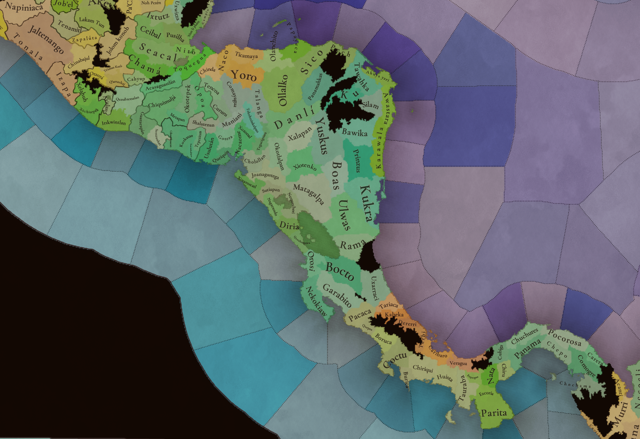
Plenty of locations here! I just want no note that the Darien Gap is an impassable wasteland, which means that any army trying to cross from modern Panama and Colombia will need transport ships to be able to do it.

Provinces
Provinces1.png

Provinces2.png


Areas
Areas1.png

Areas2.png


Terrain
Climate.png

Climate2.png

Topography.png

Vegetation.png

Vegetation2.png

A very diverse region! Most of it is covered by Tropical Jungles and Forests, but Sierra Madre Occidental and Oriental make for very specific conditions in the Mexican Altiplano, which are not only visible in the Topography map but also in the climate and vegetation of the area.

Development
Development2.png

The most developed regions in Mesoamerica are the Valley of Mexico and the Mayan coastline.

Natural Harbors
Harbors.png

There are some good ports in the Caribbean, no surprise that most of them would later become important cities in the Colonial Period.

Culture
Cultures.png

Cultures2.png

Tons of cultures!

Language
Dominant Languages1.png

Dominant Languages2.png

Court Language.png

And also languages! The first two maps are the Dominant Languages per location, while the third is the Court Languages one. The dark blue language is ‘Totozoquean’, as it is not so easily readable (something we have to change).

Religions
Religions.png

This map is today in a more advanced state, as we have merged plenty of cultural religions into regional groupings. Of these, Tonalism, Nahua, and Mayan are part of the Tonalist religious groups, while the others are part of the Folk American group (a regional split of the former ‘Animist’ group). Nahua and Mayan have their different mechanics, which we’ll talk about in future Tinto Talks. Let us know what do you think of this design and any suggestions about the religious grouping!

Raw Materials
Raw Materials1.png

Raw Materials2.png

Raw Materials3.png

Raw Materials4.png

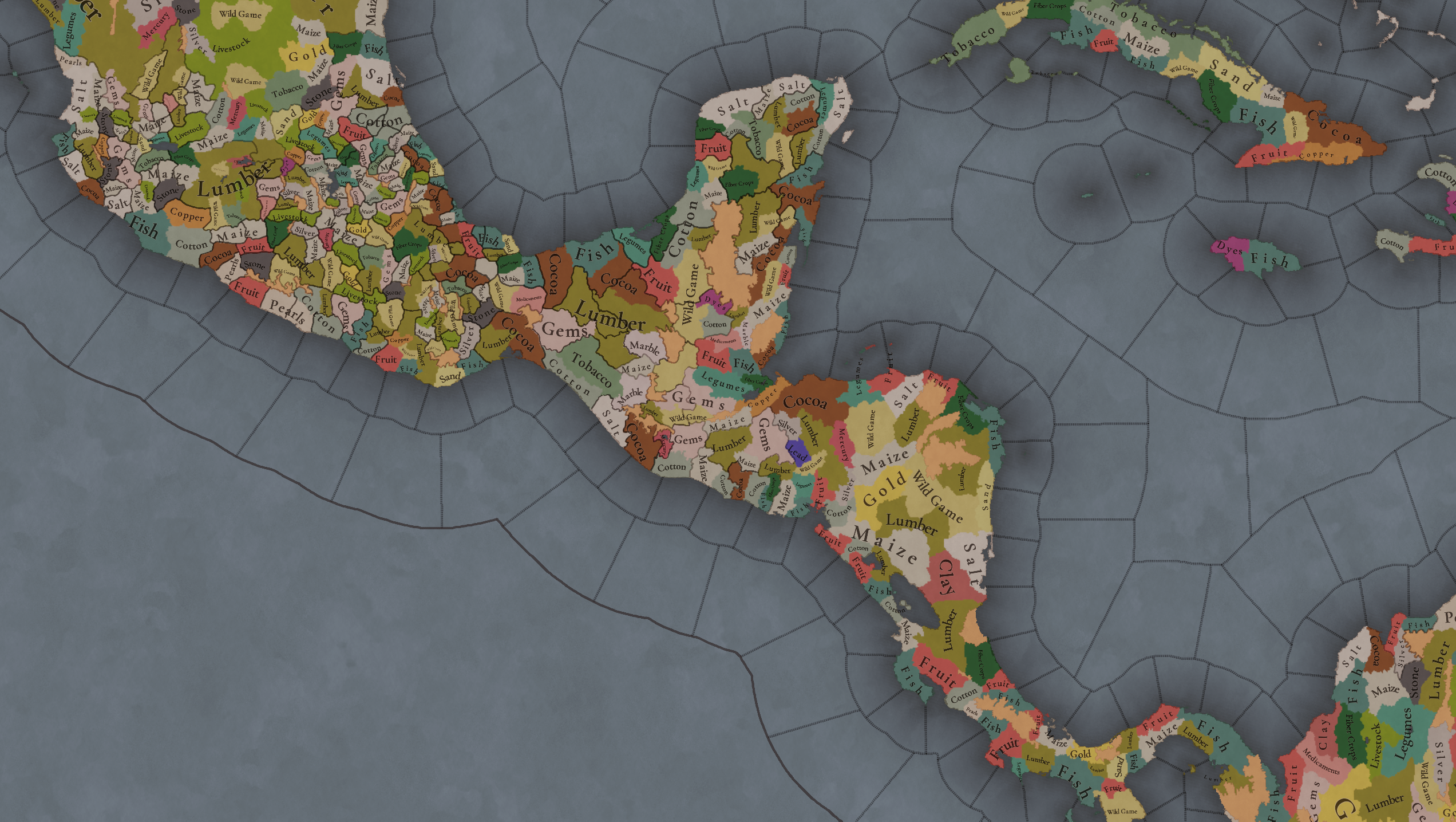
Maize is king in Mesoamerica, although there are plenty of other resources, including juicy Gold and Silver. Obsidian is not a separate resource, as it’s too regional-specific, so it’s included under the Gem coverage, but we have ways to represent it in-game; for instance, there’s a production method to produce Weaponry using Gems as an input.

Markets
Markets.png

A couple of bugs were reported while taking the screenshot of this map! But well, you can see that Azcapotzalco, Màayapáan, and Noh Petén (capital of the Itza people) are the most important ones.

Population
Population1.png

Population2.png

Population3.png

Population4.png

Population5.png

Population6.png

Population7.png

We have solved a couple of issues with the pop editor, and this week this map is in a decent state to be shown! Yay! Total numbers in the region are roughly 8.6M pops, distributed this way:
  • 523K in Aridoamerica (includes the lands to the North-West of the Purepecha Empire)
  • 6.947M in Mesoamerica (including North-Western Mayan lands)
  • 1.003M in Central America (including South-Eastern Mayan lands)
  • 151K in the Caribbean Islands

And that’s all for today! We hope you enjoyed these meaty maps! Next week we will be taking a look at the Levant Feedback, on Monday 16th, and South America, on Friday 20th! Cheers!
 
  • 117Like
  • 95Love
  • 5
  • 1
Reactions:
Well, considering that i'm a week late on this one, many of my complaints may've already been made by other people (i will, actually, shamelessly plug @nyetflix2 's great post in my comments since it helps framing what i'm thinking), but i guess that another voice kicking and screaming about the map being emptier than expected can only help the cause, hah. Let's see:
Could we get the actual Nahua location names with the macrons for long and short vowels? I've seen that at least one Japanese location (Akiō) has it, so it's certainly codeable. I know some placenames' original Nahua names aren't as immediately obvious as others, but i'd gladly gather up the Nahua-placename-with-macrons-corpus for the job if Pavía confirms that they'd put it in, heh. As far as names go, the one who actually annoys me the most is Colliman, and this is kind of a reply to:
Tecoman -> Caxitlán (optional; Tecoman being the name of the valley and Caxitlan the town)
Colima itself was founded by the Spaniards, and the name is because, the King's name was read as that by the Spanish, of course, as you captured by Colliman's culture, "King Colliman" was the ruler of the Tecos, whose original name most likely meant tetl-cah (i.e. Tecatl/Tecah), which would roughly mean "people of the stone" (steal the Kaaba achievement when?), anyway, the capital of the Tecos was originally named Caxitlán (Ācaxitlān, "place of pools", the other etymology the wikipedia article gives doesn't make sense, since the xi particle is a preffix, and would give Xicatlān instead), and located exactly at the modern city of Colima (where your location of Colliman is placed). Tecoman (name of the valley, later became the homonym colonial settlement) could be renamed to nearby Cuyutlán (Coyōtlān), where sea-salt is harvested since pre-colonial times, if you want a proper location.

But, most importantly, your depiction of the Colliman polity is also anachronistic, it had not control over all the other Teco cities until the Saltpeter War against the Purépecha, the Tecos should be divided between:
- Caxitlán (Ācaxitlān) with the current Coliman and Tecoman locations
- Tlayolan (Tlayollān) as an OLM in the homonym location
- Tamazollan (Tamazollān) with the homonym and Xilotlan locations.
- Tochpan (Tōchpan) as an OLM in the homonym location.

Besides, Chucutitlan and Coahuyana locations should be given to Zacatula, these entered the Teco sphere after Zacatula was cut off from the remaining Nahua polities by Tarascan expansion. Apatzingan should be given to the Purépecha, it is traditional Purépecha land and never was governed by Nahuas AFAIK. Tomatlan is also way too big, there should be another city-state between it and Ama. (Amapila?), Cuzalapa, which was particularly relevant in your set-up with "Oto-Manguean" culture in Jalisco, as it's i think the only state in the area for which we have proof that, in the contact period, the rulers spoke the local Otomí language, it already is present as an OLM, apparently, but it should include the coastal Zihuatlan location, since Cihuatlán itself was under the authority of Cuzalapa.
There's no real reason for Toltec, Teco and Tlaxcaltec to be separate cultures from Nahua per se, in my opinion. However, I would support splitting the Nahua culture into central, eastern and western variants, as although the Pipil are considered to have developed their own language, it was still more of a continuum and the eastern variants of Nahuatl showed more similarities to the Nawat of the Pipil. They're also different culture groups and took influences from neighboring non-Nahua cultures. In fact, Western could be neatly divided into Teco and Cuyutec(o). There could also be the Nahuatl-speaking Coixca culture in Guerrero.
I do think the Nahua blob is unwarranted, Toltec and Tlaxcaltec aren't good cultures, but the problem is the fact that the remaining stuff is simply too much blob. Taking these 2 cultures + Teco as united in the Nahua blob, i'd split them like that:
- Aztēcah (in the literal sense)/Nahuatl proper: Basically the peoples who speak Central Nahuatl, with the exception of both Guerrero groups, maybe might as well be named "Nahua".
- Cuextēcah: Huasteca and Sierra Puebla Nahuatl.
- Melahtlahtōlcah: From melaꞌtájto̱l, "(those) who speak true" basically Isthmus Nahuatl, including today's Southeastern Puebla.
- Nawat/Nahuat: the Pipil and the Nicarao. Should be lumped together because the Nicarao migration is pretty recent by 1337.
- Cōzcah: Ripping off the name of the Coixcas, Guerrero (both Balsas River and Ometepec, the latter i'm fairly sure of being from a later movement of people that hasn't happened yet by 1337) Nahuatl
- Tecos: Tecos, i think the current distribution is fine, as long as they fix Coahuyana and Chucutitlan, Sayula should be Teco, too.
- Cuyutecos: The currently Nahua pops from Ixtlahuacan-Huaxtla to the coast should be of this culture.
- Cocas: The remaining pops surrounding Lake Chapala should be of this culture, particularly in the area west and north of it (and south of the Cuyuteco area). I think an east-west extension from the Lake area to the impassable mountains to the west would be pretty good (Any Nahua minorities down the coast should be Cuyuteco, though). They should probably be majorities in the currently Tonala/Tecuexe shore of the Lake, but with the Tecuexe being the ruling class over them.
  • It NEEDS to be renamed to Otomi, or Hñähñu/Hñähño/Ñuhu/Ñhato/Ñuhmu as I noticed you guys are trying to do autonyms.
The problem currently is that it's not only Otomi as Oto-Manguean, but also Jaliscan Otomi (which though probably related, shouldn't be the same culture i think), Amuzgo (as you mentioned), the Pame (it needs to be said how wrong is the placement of Xi'oi culture in the map, it's on what should be Guamare territory), Jonaz and the Mazahua. There needs to be a full-review of the Oto-Manguean peoples present, because there's also a full array of should-be-cultures that are currently just under the Nahua-Mixtec blobs, like the Chinantecs, Mazatecs and other Popolocan speakers like the Chochos, and the Chiapanecs are missing too. All right that not EVERYONE can be a culture, but we're talking about fairly relevant absences here, especially in the light of having a "Oto-Manguean Culture" that is everything and nothing at the same time.
Popoloca in Tehuacan and Tecamachalco, and the related Mazatec in Teutila, Ixcatlan, Oxitlan
As a suggestion for the alleviation of work from our Paradoxic overlords, Popoloca and Chocho can be united in a single Ngiwa culture, and Mazatec culture should include the small Ixcatec area.
Several small unclassified cultures of Guerrero, Jalisco, Michoacan (source: Handbook of Middle American Indians, Vol. 12). Certainly not worth it to include every tiny culture whose affiliation we do not know, but I would support combining them so that we still have to deal with cultural minorities and don't easily get cultural harmony when we conquer these areas. For instance, fold Chumbia, Tolimec and Pantec into one culture present in Zacatula, Ixtapa and Chucutitlan. Fold Tamazultec, Cochin, Tiam, Otomi de Jalisco, Zapoteco de Jalisco into one non-Nahua culture in Jalisco, replacing the Otomanguean/Otomi presence there and expanding to Amollan, Tlamazollan, Sayula and Tochpan (and Xilotlan if you include the Xilotlantzinca), but still mixed with Nahua populations. I personally think if Jalisco Otomi really was related to the central Mexican Otomi, it was probably a post-contact transposition through auxiliary Otomi forces allied with the Spaniards, thus if present in 1337, was probably unrelated. Fold Cintec, Cuauhtec, Ayacaxtec and Huehuetec into one culture in the Costa Chica. Finally, Tepuztec and its neighbors in central Guerrero.
I fully support this proposal, i think it's the best way to deal with it. Although, i think that Jalisco Otomi being related doesn't necessarily mean a transposition, particularly considering that its small area (and, well, the fact that the communities which spoke it also spoke Nahuatl) at time of documentation implies a language which was already decaying, it may just be the case that a not-particularly-closely-related-language was there and the local Nahuas just called them Otomi by analogy, or by the same way that the Mexico Valley Nahuas would call the actual Otomis, it can be explained in a multitude of ways, really, and it might be better for gameplay purposes for us to assume it's related.
Totozoquean (why does it include Mixtec and Zapotec???), Otomanguean, Hokan, Chibchan are all VERY bad languages. Lenca as Misumalpan and Mixtec/Zapotec as Totozoquean, the existence of Totozoquean itself are all conjecture or just wrong. Break them down. I am amused that Xinca is the only minor language that is actually independent. I would be fine with counting Mixe-Zoquean as one language, despite them being too diverse for that too be historically accurate, but at least there's a clear relationship between them.
Just reinforcing this claim, i do think Mixe-Zoquean works, especially if we'll get only Mixe and Zoque as separate cultures, each culture could have its own dialect (Mixean and Zoquean, obviously) and it would be just fine. But Otomanguean and Chibchan have to be DESTROYED, i don't know enough about Chibchan to properly argue, but Otomanguean in-game should be like this:
Otomian language
- Otomi (proper) dialect
- Mazahua dialect
- Matlatzincan dialect (it could be its own language, but then it would be an unnecessary one-language one-dialect)
- Chinantecan dialect (for lack of better placement)
Pamean language
- Xi'oi dialect
- Jonaz dialect
Manguean language
- Me'phaa dialect (it could be its own language, but then it would be an unnecessary one-language one-dialect, unless a Subtiaba culture is made)
- Chorotega dialect
- Chiapanec dialect
Zapotec-Popolocan language
- Chochoan dialect
- Mazatecan dialect
- Zapotec dialect (it could be its own language, but then it would be an unnecessary one-language one-dialect)
Mixtecan language
- Mixtec dialect
- Amuzgo dialect
Very disappointed by the lack of settled states or even SoPs in Pacific Nicaragua. Cuauhcapolca, Nagarando, Diria, Tezoatega and Mistega should be added here. Nicoya also qualifies as a settled state IMO, and possibly the area surrounding Choluteca in Honduras too. These societies used screenfold books and used cacao currency like their Central Mexican relatives. They had decently sized towns and were more populous and sedentary in general than the Chibchans of Costa Rica. William Fowler and Constenla Umaña should be productive reading on this topic.
That was actually my main let-down from this Tinto Maps, i was hopeful that, this time, actual Central America (i.e. not-Mexico) would get the love it deserves, relevancy-wise, quite sad to have been wrong about that, i didn't expect it to be perfect, but i expected it to feature at least a pair of settled states, particularly Nicoya, by the description:
The population of Nicoya was a political, religious and economic center, located a short distance from the modern-day city of this name. (In the middle of the 16th century, there were two other dependencies also known as Nicoya, one larger than the other.) In Nicoya would reside a high chief, who held that post for life and exercised political authority, and would carry out religious and ceremonial functions. It appears that there was prevalently a dynasty-elective system for chief succession. Fernández de Oviedo indicated that this priest had other principal vassals and horseman called galpones, who would accompany him and protect him, and be his court subjects and captains. It is possible that these elders, whom the chronicler describes as arrogant and cruel, represented the various tributary villages of Nicoya.
Is that not the textbook definition of a settled state?
Ideally the Lencas would be split into three different SoPs (Care, Maniani/Sulaco and Manalaca/Popocatepet, the last being the priority as they did not join in Lempira's rebellion). If you create a Cerquin location out of Opoa, that can be a separate SoP as well.
Reinforcing as well, and it lets me talk about the lumping of some entire cultures as one single SoP, and the lack of others as any SoP at all. All i'm saying is that:
1734888069087.png

This shouldn't happen, not in this region, at all. At the very LEAST, this should be filled to the brink with SoPs, and at best, there should be the necessary settled states on here. But my pet peeve is actually somewhere else:
1734888207353.png

Why aren't the Ciboney a SoP? Well, actually, they should be many SoPs, but them being at the first place would help a lot. On other terms, why aren't the Taíno separate SoPs? They should be distributed according to the Chiefdoms of Hispaniola, Puerto Rico should be a Boricua people SoP, and the Cuban branch at the very least as a "Cuban (Cubao?) people" SoP (and at best as the actual chiefdoms). It annoys me as well that the Kalinago aren't an SoP, considering that the culture map gives away the fact that they're also on the mainland, there should be two separate SoPs for them: Mainland (Kaliña, that would include Trinidad) and Island (Kalinago), by this point the Island SoP should be a Kalina (the culture's name should be changed to Kalina, really) minority ruling over majority Iñeri, or simply Taíno if you don't want to create another culture, people. Eventually the Kalinago SoP should somehow become the Kalinago culture (which would speak the Iñeri's dialect, according to in-game mechanics). The Lucayans should be an SoP as well. The Taíno SoPs should be societally more advanced than the Siboney and Lucayan ones, but the Kalinago ones should be at a similar pace as well.
 
  • 6
  • 4Like
  • 1
Reactions:
I do think the Nahua blob is unwarranted, Toltec and Tlaxcaltec aren't good cultures, but the problem is the fact that the remaining stuff is simply too much blob. Taking these 2 cultures + Teco as united in the Nahua blob, i'd split them like that:
- Aztēcah (in the literal sense)/Nahuatl proper: Basically the peoples who speak Central Nahuatl, with the exception of both Guerrero groups, maybe might as well be named "Nahua".
- Cuextēcah: Huasteca and Sierra Puebla Nahuatl.
- Melahtlahtōlcah: From melaꞌtájto̱l, "(those) who speak true" basically Isthmus Nahuatl, including today's Southeastern Puebla.
- Nawat/Nahuat: the Pipil and the Nicarao. Should be lumped together because the Nicarao migration is pretty recent by 1337.
- Cōzcah: Ripping off the name of the Coixcas, Guerrero (both Balsas River and Ometepec, the latter i'm fairly sure of being from a later movement of people that hasn't happened yet by 1337) Nahuatl
- Tecos: Tecos, i think the current distribution is fine, as long as they fix Coahuyana and Chucutitlan, Sayula should be Teco, too.
- Cuyutecos: The currently Nahua pops from Ixtlahuacan-Huaxtla to the coast should be of this culture.
- Cocas: The remaining pops surrounding Lake Chapala should be of this culture, particularly in the area west and north of it (and south of the Cuyuteco area). I think an east-west extension from the Lake area to the impassable mountains to the west would be pretty good (Any Nahua minorities down the coast should be Cuyuteco, though). They should probably be majorities in the currently Tonala/Tecuexe shore of the Lake, but with the Tecuexe being the ruling class over them.
Pretty much agree with the split, but please no "Aztec(ah)" culture by any means in this game. Call it Central Nahua if you must.

I liked the idea of "Olmec(a)" being the name for the eastern Nahua culture, although I'm not sure this was ever an ethnic term per se (ie, unsure whether it was applied to Nahuas only, Mixe-Zoques only, or both).

There is apparently some discussion as to whether the Cocas were Nahuatl-speaking or some sort of indigenes (considering the supposed tradition of being expelled from Ixtlan by Nahuas), but there's not a lot of information about it, and even less reliable information unfortunately.

Just reinforcing this claim, i do think Mixe-Zoquean works, especially if we'll get only Mixe and Zoque as separate cultures, each culture could have its own dialect (Mixean and Zoquean, obviously) and it would be just fine. But Otomanguean and Chibchan have to be DESTROYED, i don't know enough about Chibchan to properly argue, but Otomanguean in-game should be like this:
Otomian language
- Otomi (proper) dialect
- Mazahua dialect
- Matlatzincan dialect (it could be its own language, but then it would be an unnecessary one-language one-dialect)
- Chinantecan dialect (for lack of better placement)
Pamean language
- Xi'oi dialect
- Jonaz dialect
Manguean language
- Me'phaa dialect (it could be its own language, but then it would be an unnecessary one-language one-dialect, unless a Subtiaba culture is made)
- Chorotega dialect
- Chiapanec dialect
Zapotec-Popolocan language
- Chochoan dialect
- Mazatecan dialect
- Zapotec dialect (it could be its own language, but then it would be an unnecessary one-language one-dialect)
Mixtecan language
- Mixtec dialect
- Amuzgo dialect
This is an acceptable grouping, if not totally realistic. But if you're going to fold Chinantec into the Otomi language, Pame and Jonaz need to be there as well, they are much more clearly and closely related to Otomi, and are even included under the label "Otomi" by some definitions while the Chinantecs are not.

And if I could change one other thing, I would really rather have Popoloca and Zapotec be separate. The unity of the Zapotec languages goes back to like BC times, they have a rather distinct identity.

Also check my original comment again, I updated my section on languages.
Although, i think that Jalisco Otomi being related doesn't necessarily mean a transposition, particularly considering that its small area (and, well, the fact that the communities which spoke it also spoke Nahuatl) at time of documentation implies a language which was already decaying, it may just be the case that a not-particularly-closely-related-language was there and the local Nahuas just called them Otomi by analogy, or by the same way that the Mexico Valley Nahuas would call the actual Otomis, it can be explained in a multitude of ways, really, and it might be better for gameplay purposes for us to assume it's related.
My personal theory is that they were a local pre-Nahua group who were not as sedentary/agricultural/urbanized as others, and thus labelled "Otomitl" (probably meaning archer/hunter) by Nahuas, thus the connection with the Otomi we know being only coincedental, much like the various "Chontal" and "Popoloca" groups. If they really were related to the "real" Otomi, wouldn't archaeology give us some indication as to population movement from the Otomi area to this part of Jalisco? But as far as I know, there is no such indication. Of course, it's all pretty minor in the end, and different interpretations are defensible in the absence of any real evidence.
 
Last edited:
  • 2Like
  • 1
Reactions:
View attachment 1234763
Why aren't the Ciboney a SoP? Well, actually, they should be many SoPs, but them being at the first place would help a lot. On other terms, why aren't the Taíno separate SoPs? They should be distributed according to the Chiefdoms of Hispaniola, Puerto Rico should be a Boricua people SoP, and the Cuban branch at the very least as a "Cuban (Cubao?) people" SoP (and at best as the actual chiefdoms). It annoys me as well that the Kalinago aren't an SoP, considering that the culture map gives away the fact that they're also on the mainland, there should be two separate SoPs for them: Mainland (Kaliña, that would include Trinidad) and Island (Kalinago), by this point the Island SoP should be a Kalina (the culture's name should be changed to Kalina, really) minority ruling over majority Iñeri, or simply Taíno if you don't want to create another culture, people. Eventually the Kalinago SoP should somehow become the Kalinago culture (which would speak the Iñeri's dialect, according to in-game mechanics). The Lucayans should be an SoP as well. The Taíno SoPs should be societally more advanced than the Siboney and Lucayan ones, but the Kalinago ones should be at a similar pace as well.
I completely agree with the suggested SoPs additions to the region; However, I insist that it would be a waste if the Taino Chiefdoms of Hispaniola were not represented as settled states, even more when there exists a tribal government form with associated mechanics already in game, and as you said it yourself, the taino were a more complex society than the ones found in their immediate surroundings.

The only thing I would add would be that the uncolonized bits of the island of Hispaniola should be assigned to a Ciguayo SoP (in the northeast) and a Ciboney SoP (in the southwest)


Edit: Corrected Guanahatabey to Ciboney.
 
Last edited:
  • 3
  • 1Like
Reactions:
The only thing I would add would be that the uncolonized bits of the island of Hispaniola should be assigned to a Ciguayo SoP (in the northeast) and a Guanahabatey SoP (in the southwest)
The Guanahatabey lived in the far west of Cuba. Hispaniola's Tiburon peninsula was inhabited by Ciboneys. I don't know about the Ciguayo, but I would probably argue against a Guanahatabey SoP, as they seem to have been basically hunter-gatherers as opposed to the agricultural Tainos. I also don't think much has been written about Guanahatabey caciques or any sort of political structure.

On the other hand, it would be amazing to see individual cacicazgos of Cuba as SoPs, and of course to divide up Hispaniola as well.
 
Last edited:
  • 2Like
  • 2
Reactions:
There isn't quite as much information out there as the Costa Rican kingdoms, but I'm thinking much of Panama should also be home to either SoPs or tribal kingdoms. Check out Urraca and the Spanish wiki page on the history of Panama, they mention chiefdoms.

Here's a map of the chiefdoms at the moment of contact, where green represents "kingdoms" (treated as the same level as most Mesoamerican states) and orange represents tribes with less clear political organization.

1734914502227.png
 
  • 3Love
  • 1Like
  • 1
Reactions:
The Guanahatabey lived in the far west of Cuba. Hispaniola's Tiburon peninsula was inhabited by Ciboneys. I don't know about the Ciguayo, but I would probably argue against a Guanahatabey SoP, as they seem to have been basically hunter-gatherers as opposed to the agricultural Tainos. I also don't think much has been written about Guanahatabey caciques or any sort of political structure.

On the other hand, it would be amazing to see individual cacicazgos of Cuba as SoPs, and of course to divide up Hispaniola as well.
You are right, mixed up the Guanahatabey with the Ciboney, thanks for clearing that up.

I proposed the Ciboney and Ciguayo as SoP exactly because they were neither agricultural nor organized politically,and yet ressited agaisnt Taino advancement into those regions and where very hostile against the first European explorers, and that seems to be the paramount razor used by the devs when defining what are and are not SoP's when looking at north America and even examples as the saami in europe.
 
Last edited:
  • 2Like
Reactions:
I liked the idea of "Olmec(a)" being the name for the eastern Nahua culture, although I'm not sure this was ever an ethnic term per se (ie, unsure whether it was applied to Nahuas only, Mixe-Zoques only, or both).
That's actually a pretty clever solution, it doesn't seem to be ethnical, but rather geographical (just like the Huastec heartland was still called Cuextlán/La Huasteca regardless of actually being settled by Huastecs), so it would fit regardless.
There is apparently some discussion as to whether the Cocas were Nahuatl-speaking or some sort of indigenes (considering the supposed tradition of being expelled from Ixtlan by Nahuas), but there's not a lot of information about it, and even less reliable information unfortunately.
My speculation is that they (or at least a part of them) were a non-Nahua group that eventually Nahualized, not that it matters that much, they didn't seem to leave a particularly different linguistic trace, at least i haven't seen things about it.
This is an acceptable grouping, if not totally realistic. But if you're going to fold Chinantec into the Otomi language, Pame and Jonaz need to be there as well, they are much more clearly and closely related to Otomi, and are even included under the label "Otomi" by some definitions while the Chinantecs are not.
That was actually something i thought about, but i wondered if it wouldn't make any "Otomian" language unnecessarily large. Maybe something like this would work:
Otomian Language
- Otomi dialect
- Mazahua dialect
- Xi'oi dialect
- Jonaz dialect
- Matlatzincan dialect
And then Chinantecan as its own thing?
And if I could change one other thing, I would really rather have Popoloca and Zapotec be separate. The unity of the Zapotec languages goes back to like BC times, they have a rather distinct identity.
And, fair.
However, I insist that it would be a waste if the Taino Chiefdoms of Hispaniola were not represented as settled states, even more when there exists a tribal government form with associated mechanics already in game, and as you said it yourself, the taino were a more complex society than the ones found in their immediate surroundings.
I'm actually in full support for this, just tried to work around what seems to be the initial conceptualization for the area. I'm fully in-support for settled states in Hispaniola, just like all over Central America, as i have complained about.
 
  • 4Like
  • 1
Reactions:
Colima itself was founded by the Spaniards, and the name is because, the King's name was read as that by the Spanish, of course, as you captured by Colliman's culture, "King Colliman" was the ruler of the Tecos, whose original name most likely meant tetl-cah (i.e. Tecatl/Tecah), which would roughly mean "people of the stone" (steal the Kaaba achievement when?), anyway, the capital of the Tecos was originally named Caxitlán (Ācaxitlān, "place of pools", the other etymology the wikipedia article gives doesn't make sense, since the xi particle is a preffix, and would give Xicatlān instead), and located exactly at the modern city of Colima (where your location of Colliman is placed). Tecoman (name of the valley, later became the homonym colonial settlement) could be renamed to nearby Cuyutlán (Coyōtlān), where sea-salt is harvested since pre-colonial times, if you want a proper location.

But, most importantly, your depiction of the Colliman polity is also anachronistic, it had not control over all the other Teco cities until the Saltpeter War against the Purépecha, the Tecos should be divided between:
- Caxitlán (Ācaxitlān) with the current Coliman and Tecoman locations
- Tlayolan (Tlayollān) as an OLM in the homonym location
- Tamazollan (Tamazollān) with the homonym and Xilotlan locations.
- Tochpan (Tōchpan) as an OLM in the homonym location.

Besides, Chucutitlan and Coahuyana locations should be given to Zacatula, these entered the Teco sphere after Zacatula was cut off from the remaining Nahua polities by Tarascan expansion. Apatzingan should be given to the Purépecha, it is traditional Purépecha land and never was governed by Nahuas AFAIK. Tomatlan is also way too big, there should be another city-state between it and Ama. (Amapila?), Cuzalapa, which was particularly relevant in your set-up with "Oto-Manguean" culture in Jalisco, as it's i think the only state in the area for which we have proof that, in the contact period, the rulers spoke the local Otomí language, it already is present as an OLM, apparently, but it should include the coastal Zihuatlan location, since Cihuatlán itself was under the authority of Cuzalapa.
Tlacalahuastla should be changed to Tepetitango. Also I wonder why the "Ama." tag when it should be Tepetitango, by the way since Tecomán is represented as part of Caxitlán (Colima) the same could be applied for Tepetitango.


Agree in the general suggestion.
Coalcomán and Pómaro are perfect, while Coahuayana itself should be Alima (Aliman/Alimanzi).
The location to the east from Apatzingan could be named Tepalcatepec (Tlapalcatepec) for a nahua focus (included Tetlaman) but for the purepecha could be Arimao (later moved to Pizandaro), even the river was named both Tlapalcatepec and Arimao but the sites are different, the nahua to the west and the purepecha to the east.
Also Petatlán is great for Guerrero´s coast.

  • Cárdenas-Munguía, F. J. 2000. Los asentamientos humanos en el siglo XVII en la provincia de Colima. Sistema de poblados y su estructura interna. Universidad Nacional Autónoma de México.
  • Novella, R. 1996. La Costa de Michoacán, Méjico, en el siglo XVI. Anales del Museo de América, 4. 25-37.
  • Roskamp, H. 1998. La Historiografía Indigena de Michoacán, El lienzo de Jucutácato y los Títulos de Carapan. CNWS. Leiden University.
  • Sauer, C. 1976. Colima de la Nueva España en el siglo XVI. JUS.
 
  • 2Like
  • 2
  • 1
Reactions:
Hi Tinto, there are two locations in Central america that I consider relevant to the historical period and level of detail of the game
.
The first is the Archipelago of San Andrés, Providencia and Santa Catalina (as a single province, not individual islands), today part of Colombia but very important in the colonial period in the Caribbean for being right between the very important Spanish positions in Central America and Colombia such as Cartagena de Indias and Panama.
These islands have been populated since 1629 and currently have 65,663 inhabitants. They were fought over several times between Spain and England, which took possession of them on different occasions and used them to invade the Caribbean coast. There are very important pirates such as Henry Morgan who used them as a base of operations and Spain would not take them until the American War of Independence.

The next territory, also an archipelago, is much larger with almost 100 thousand inhabitants and populated even at the start date of the game, The Bay Islands in Honduras
These islands were also a point of invasion between England and Spain and came to be totally controlled by pirates for a period, the United Kingdom also used them to invade the Central American coast of the Spanish possessions and defend Belize. The indigenous population of the island, probably Pech, was enslaved and used as labor by the British and pirates who settled on the islands, so when Spain conquered the territory they relocated them to the continent. They were also the point of expansion of the Garifuna ethnic group that was brought from the Antilles by England to repopulate the islands but they rebelled and took over and then expanded throughout the Gulf of Honduras. The English also created an official colony on the island administered from Belize but due to pressure from the United States they ended up seizing them to Honduras but the British population continues on the islands

I also think that some other minor islands could have their own province but probably do not have the same level of relevance, such as Cuzumel, an ancient Mayan island, from where Spain would try to take Yucatan but once in colonial times it was practically depopulated, La Isla del Carmen which was also a pirate nest that Spain had a hard time sweeping and from where the Mexican coast was plundered.

This is my first time making suggestions so sorry if my English is a bit off and thanks for reading.
 

Attachments

  • istockphoto-1160360840-612x612.jpg
    istockphoto-1160360840-612x612.jpg
    34,6 KB · Views: 0
  • Honduras_Bay_Islands-Roatan-Utila-Guanaja-Cayos_cochinos.jpg
    Honduras_Bay_Islands-Roatan-Utila-Guanaja-Cayos_cochinos.jpg
    103,8 KB · Views: 0
  • mapa localizacion2.jpg
    mapa localizacion2.jpg
    54,2 KB · Views: 0
  • 3Like
  • 1
Reactions:
Hi Tinto, there are two locations in Central america that I consider relevant to the historical period and level of detail of the game
.
The first is the Archipelago of San Andrés, Providencia and Santa Catalina (as a single province, not individual islands), today part of Colombia but very important in the colonial period in the Caribbean for being right between the very important Spanish positions in Central America and Colombia such as Cartagena de Indias and Panama.
These islands have been populated since 1629 and currently have 65,663 inhabitants. They were fought over several times between Spain and England, which took possession of them on different occasions and used them to invade the Caribbean coast. There are very important pirates such as Henry Morgan who used them as a base of operations and Spain would not take them until the American War of Independence.

The next territory, also an archipelago, is much larger with almost 100 thousand inhabitants and populated even at the start date of the game, The Bay Islands in Honduras
These islands were also a point of invasion between England and Spain and came to be totally controlled by pirates for a period, the United Kingdom also used them to invade the Central American coast of the Spanish possessions and defend Belize. The indigenous population of the island, probably Pech, was enslaved and used as labor by the British and pirates who settled on the islands, so when Spain conquered the territory they relocated them to the continent. They were also the point of expansion of the Garifuna ethnic group that was brought from the Antilles by England to repopulate the islands but they rebelled and took over and then expanded throughout the Gulf of Honduras. The English also created an official colony on the island administered from Belize but due to pressure from the United States they ended up seizing them to Honduras but the British population continues on the islands

I also think that some other minor islands could have their own province but probably do not have the same level of relevance, such as Cuzumel, an ancient Mayan island, from where Spain would try to take Yucatan but once in colonial times it was practically depopulated, La Isla del Carmen which was also a pirate nest that Spain had a hard time sweeping and from where the Mexican coast was plundered.

This is my first time making suggestions so sorry if my English is a bit off and thanks for reading.
The Islas Marias seem to be a location in the game, despite seemingly having no historical relevance whatsoever. Any of these have much better cases for being included than Islas Marias IMO.
 
  • 5Like
  • 1
Reactions:
I find a bit weird the naming of the areas in Mexico (and possibly also the naming of the provinces). I believe you named them according to an important province, but I find the naming inconvenient. For the areas, I find that at least Tetzcoco should be named (Central) Mexico, Tzintzuntzan should be named Michoacan, Tututepec should be named Oaxaca (or Huaxyacac), and Ma'ya'ab should be named Yucatan (or Yu Ka t'aan). For the provinces, either Tetzcoco or Azcapotzalco could be named Anahuac, which is the prehispanic name to the area around the Mexico Valley lakes
 
  • 3
  • 1
Reactions:
The devs forgot that "Island Caribs" spoke an Arawakan language, as the Carib conquerors or immigrants were probably only a small minority among the Arawakan Iñeri people, and ended up adopting their language. Actually, the Lesser Antilles should possibly still be majority Iñeri, though I'm not too sure of the exact timing of the Carib migration.
Hey, i can help with that! The most certain, but also the most vague estimate for the Carib migration is basically 1000-1500, which is roughly the period where archaeologically Cayo-style pottery (much in common with the mainland Koriabo culture, most often connected with the Kalina/Mainland Caribs) supercedes the Suazoid tradition in the Lesser Antilles, which is so far as i know the only archaeological evidence of any Cariban migration. What we know from recorded history suggests that any actual migration occurred at the mid-to-latter half of this 500 year period, since we have reports of the Island Caribs (particularly men) speaking "a language in common" with the Mainland ones, and the group as a whole seems to only ethnogenesis its way into a proper "Kalinago" culture, instead of Kalina migrants ruling over Arawakan wives and slaves, amidst the colonial period.

With that, as i proposed earlier, the best depiction would be to have Kalina cultural minorities ruling over an Arawakan majority, but by 1337 the Caribs shouldn't be that much to the north, from Guadeloupe to the North, there should be an "Iñeri" SoP to portray the remaining independent Eastern Taíno, and that should include Barbados if we're going with the fact that the Spaniards didn't consider its inhabitants as Carib. I think it would also be a great idea for the Island Caribs to be split in more than a single SoP, i couldn't find it when i was making my earlier post, but this study of Carib attacks on colonial forces offers a great analysis for how to portray Carib SoPs purposes, especially considering that it includes how many times the Mainland supported their Island brethren. For a better understanding of how the Kalinago worked, a good, compact, source, is The Cultural Mosaic of the Indigenous Caribbean, where in the Lesser Antilles section he goes over Carib politics, a few good snips to point out in particular are:
Sociopolitical institutions among the seventeenth century Caraibes, as recorded by the French, were considerably less complex than those described for the Taino of the Greater Antilles. The missionaries’ accounts and modem scholars are generally agreed that there was a pattern of autonomous villages consisting of extended families led by patriarchal headmen. Occasionally, men from several villages would participate in wartime confederacies under the leadership of once or more ubutu, or war chiefs (Rouse 1948:555). The war chief apparently held the position for life, and enjoyed special treatment during feasts and times of war. These leaders were reported to have been more polygamous than headmen, yet did not seem to enjoy an extraordinary (i.e. non-producing) economic position, nor did they receive extraordinary mortuary treatment in death (Dreyfus 1976:90-91; Rouse 1948: 558-559). From seventeenth century accounts it appears that centrifugal or disintegrative forces kept multi-village polities from becoming permanent. One often-cited reason for this was a strong sense of political independence among the Caribs. Labat observed that: "there are no people in the world so jealous of their liberty, or who resent more the smallest check to their freedom. They laugh at us for obeying and respecting our rulers, and say that we must be their slaves, and that since we allow them to give us orders we must also be cowards." (Labat 1970: 104) [...] As Dreyfus (1976:89; original emphasis) observes, however: "One ought not say that the Caraibes had not chiefs “save in times of war”, for they were at war all the time. Among them, war was not an accident, a disruption of normal life; it was an element of their social structure, a condition without which the network of kinship relations and alliances, residence patterns, exchange of goods, and rituals of initiation and accession to chiefship, would not exist. Some forms of authority and power are permanently attached to the functions of a war chief, who is, in fact, a political chief, and structural inequalities are well attested in the Caraibe system."
Descent and residence patterns among the Caribs are difficult to reconstruct, and although their characterization as a matrilineal society (Steward 1948:25) is probably broadly correct, there is additional variability and complexity in the social norms covering these matters. To the extent that descent was carefully reckoned, which does not appear from the seventeenth century documents to be great, there seems to be a form of double descent, with men determining descent through the patriline and women through their matriline. Rouse (1948:558) categorized residence patterns as matrilocal, while acknowledging that several deviations from this model existed; he noted that patrilocality was common among higherranking males, and that occasionally girls might be raised in the family of their affianced male. Dreyfus also remarks that “a man of ordinary status would go, upon his marriage, to live in the village where the father of his bride was headman” (1976:90; original emphasis). Dreyfus concurs that among higher-ranking heads of villages, different patterns applied. It must be remembered, however, that observations of descent and residence patterns among the Caribs, from which these interpretations derive, were made after Carib populations had been severely affected by more than a century of warfare, population decline, and relocation from island to island. The difficulties in reconstructing clear patterns of social organization almost certainly stem from this fact. An example of the potential interpretive problems raised is Pkre Labat’s observation of widespread polygamy among Carib men of ordinary status (Labat 1970: 76-7); this contradicts the general reconstruction of marriage patterns in which only headmen or men of higher status would marry more than one woman.
Speculative, of course, but the latter is probably derived from the fact that pre-colonial Island Carib society was probably very heterogeneous, as in, since the main economic activity for the men was war, something like Carib men/Arawak wives (who may've been acquired by slave-taking)/Arawak slaves created a situation where customs and descent are very sex-centric, and Kalinago language developed out of the fact that the mothers who end up teaching their children Arawak will eventually win out the linguistic war if for any reason the man-niche of "war! war! war!" collapses, and that was exactly what happened with the advent of colonization, particularly considering the fact that the Caribs became the #01 Spanish slaving target for the first half of the 16th century.

Also, unrelated, but there should be Arawak pops in Trinidad to portray the Shebaya.
 
  • 2Like
  • 1
Reactions:
cultures feedback labelled 11.png

Updated my suggestion with a proposed culture map. Open to feedback.

Like I said, I'd support splitting off Eastern Nahua/Olmec, Cuyuteco/Ameca, Pochutec and Coixca from the larger Nahua culture.

I'd also support merging Putun and Yokot'aanob cultures.

I chose Tuxtec as the name for Chontal de Guerrero and Tequistlatec for Chontal de Oaxaca, to avoid confusion. Tiam and Cochin are two of many possible names for the catch-all non-Nahua culture of Jalisco.

The Maya regions probably need more cultural overlap and mixing, but I don't know specifics.

I didn't include the small undocumented languages of the Costa Chica, but they would be a significant minority in Azoyu.
 
Last edited:
  • 3Like
  • 1Love
Reactions:
Also I think you are relying too much common perception of important resources for mesoamerica rather than what was actually important. Amaranth & Chia were both very important for the food with chia oil being the primary oil for pre-contact Lacquerware and later colonial oil painting, maguey was important for textiles (which most commoners used rather than cotton) and sacred pulque (octli in Nahuatl) it wasn't just a fiber crop, feathers were important for featherwork which would because an important expression of indigenous craftmanship after Christianization, where is Guatemalan Jade one of the most valuable possessions of the Mesoamericans, or amate bark paper one of the common tributes the triple alliance asked for from vassals, and the Maya had been beekeeping for centuries by this point
will raw materials be dynamic because if it is then there should be no provinces with livestock as the only domestic animals Mesoamericans had for meat were dogs, turkeys, and Muscovy ducks.
(in the map about Northern America I also noticed that there were no dye provinces even though Indigo was an important commodity that many slaves were forced to produce, also no yaupon holly which was important to many natives of the southeast as well as popular in Europe before it was given the scientific name of Ilex Vomitoria and because it was so abundant that it threated the profits of the British east Indian company)
Talking about raw materials, Obsidian as Gems and Feathers as Wild Game were adressed, then we can guess Maguey (Agave) would be Fiber Croops.

A couple of notorious absences are the Copal Incense abundant mainly along the Balsas River Basin and the Plicopurpura pansa snail from the pacific coast used as Dyes mostly on Oaxaca. By the way the Chochineal as Dyes is also underepresented.

The particular case of the amber from Simojovel Chiapas is also a notorious omission.
 
  • 3
  • 2Like
Reactions:
View attachment 1235062

Updated my suggestion with a proposed culture map. Open to feedback.

Like I said, I'd support splitting off Eastern Nahua/Olmec, Cuyuteco/Ameca, and perhaps Coixca from the larger Nahua culture.

I'd also support merging Putun and Yokot'aanob cultures.

I chose Tuxtec as the name for Chontal de Guerrero and Tequistlatec for Chontal de Oaxaca, to avoid confusion. Tiam and Cochin are two of many possible names for the catch-all non-Nahua culture of Jalisco.

Didn't even try to touch the Huasteca region yet, might do so in the future. I think there are some Otomi (and Tepehua) minorities yet to add there.

I didn't include the small undocumented languages of the Costa Chica or central Guerrero, as there are no locations where they would form majorities.
I am all for the use of Tzaultec for the the culture of the south of Jalisco+Colima and Cuyutec for the northen Coast+Ameca region.
When we talk about the Nahua in the Occidente is clear that many times (mostly to the south and coast of the region) the ruling class was Nahua or at least Nahuatized but there were always at least another local population in every place of the area. The peoples of the north like Tecuexe, Caxcan, Cora and Huichol were the ones that keeped more their place as elites (also the Totorame and Tahue if we go to Sinaloa).
 
  • 3Like
  • 1
Reactions:
When we talk about the Nahua in the Occidente is clear that many times (mostly to the south and coast of the region) the ruling class was Nahua or at least Nahuatized but there were always at least another local population in every place of the area.
Do you have any reading on this? I only really know about the "other" languages from the relaciones geograficas through the Handbook of Middle American Indians.
 
  • 1Like
Reactions:
Do you have any reading on this? I only really know about the "other" languages from the relaciones geograficas through the Handbook of Middle American Indians.
Ramírez-Flores, J. 1980. Lenguas indígenas de Jalisco. Gobierno de Jalisco, Secretaría General.
 
  • 2Like
Reactions:
Thank you. Do you happen to know of any to read it for free? My usual methods have failed me again unfortunately.
Sorry not in digital. The copy I cheacked is in the Biblioteca Pública del Estado de Jalisco that is in holydays break.

By the way I corrected my location of the Sierra El Cuale more to the west and extended the Sierra de Cacoma more to the north to better represent the route from Talpa to Tomatlán through Desmoronado and El Bramador.