• We have updated our Community Code of Conduct. Please read through the new rules for the forum that are an integral part of Paradox Interactive’s User Agreement.

Tinto Maps #29 - 13th of December 2024 - Central America

Hello everybody, and welcome to Tinto Maps, the happy Fridays for map lovers! Today, we will be looking at Central America, which includes the Caribbean. Before we start, I want to introduce you @RaulTrullenque , the only member of our Content Design team who had not yet gone public, and who worked really hard on the maps and content of the Central American and South American regions.

And now let’s get started without further ado!

Countries
Countries1.png

Countries2.png

Countries3.png

Countries4.png

Countries5.png

Countries6.png

Countries7.png

Tenochtitlan.png

Mayan.png
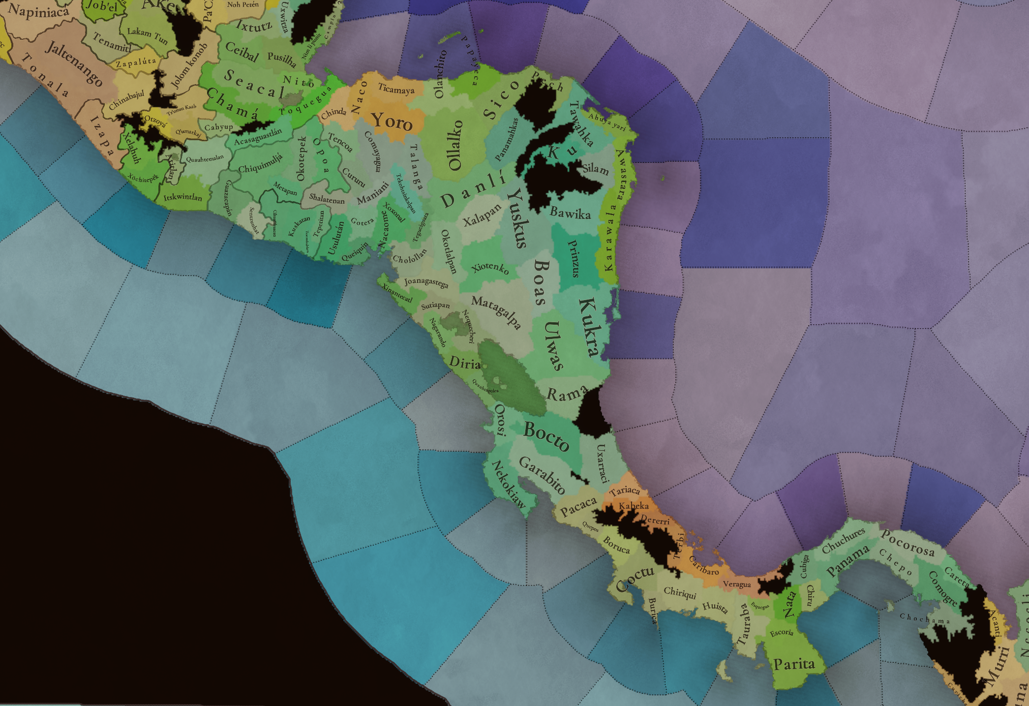
Welcome to the Mesoamerican Thunder Dome! This area is characterized by its numerous Altepetl, more or less comparable to city-states. Most of them are ruled in 1337 by peoples of Nahua origin, something that you may see much more clearly in the culture map. The biggest power in this moment is the Empire of P’urhépecherio, though, founded by the Purepecha people. In any case, you may notice that there’s a lot of detail in this area, including a tiny Nahua settlement recently founded on an island over Lake Texcoco, Tenochtitlan. This is the first time in a PDX GSG that we have the island itself present on the map, although the location covers some more land over the lake coast, to make it playable. Finally, we also have the Mayan polities of the Postclassic Period, of which Cocom, with its capital Màayapáan, was the most important, along with others, such as K’iche’ and its capital Q’umarkaj.

SoPs
SoPs1.png

SoPs2.png

SoPs3.png

SoPs4.png
On the outskirts of the Mesoamerican polities, there are plenty of peoples organized on different ways. To the north, we have the ones that populate the area known as Aridoamerica, which were collectively termed by the Nahua as ‘Chichimeca’. We also have plenty of societies close to the Mayan lands and the Isthmus. And, finally, the Taíno people populate some of the biggest islands in the Caribbean.

Locations
Locations1.png

Locations2.png

Locations3.png

Locations4.png

Locations5.png

Locations6.png

Locations7.png

Locations8.png

Plenty of locations here! I just want no note that the Darien Gap is an impassable wasteland, which means that any army trying to cross from modern Panama and Colombia will need transport ships to be able to do it.

Provinces
Provinces1.png

Provinces2.png


Areas
Areas1.png

Areas2.png


Terrain
Climate.png

Climate2.png

Topography.png

Vegetation.png

Vegetation2.png

A very diverse region! Most of it is covered by Tropical Jungles and Forests, but Sierra Madre Occidental and Oriental make for very specific conditions in the Mexican Altiplano, which are not only visible in the Topography map but also in the climate and vegetation of the area.

Development
Development2.png

The most developed regions in Mesoamerica are the Valley of Mexico and the Mayan coastline.

Natural Harbors
Harbors.png

There are some good ports in the Caribbean, no surprise that most of them would later become important cities in the Colonial Period.

Culture
Cultures.png

Cultures2.png

Tons of cultures!

Language
Dominant Languages1.png

Dominant Languages2.png

Court Language.png

And also languages! The first two maps are the Dominant Languages per location, while the third is the Court Languages one. The dark blue language is ‘Totozoquean’, as it is not so easily readable (something we have to change).

Religions
Religions.png

This map is today in a more advanced state, as we have merged plenty of cultural religions into regional groupings. Of these, Tonalism, Nahua, and Mayan are part of the Tonalist religious groups, while the others are part of the Folk American group (a regional split of the former ‘Animist’ group). Nahua and Mayan have their different mechanics, which we’ll talk about in future Tinto Talks. Let us know what do you think of this design and any suggestions about the religious grouping!

Raw Materials
Raw Materials1.png

Raw Materials2.png

Raw Materials3.png

Raw Materials4.png

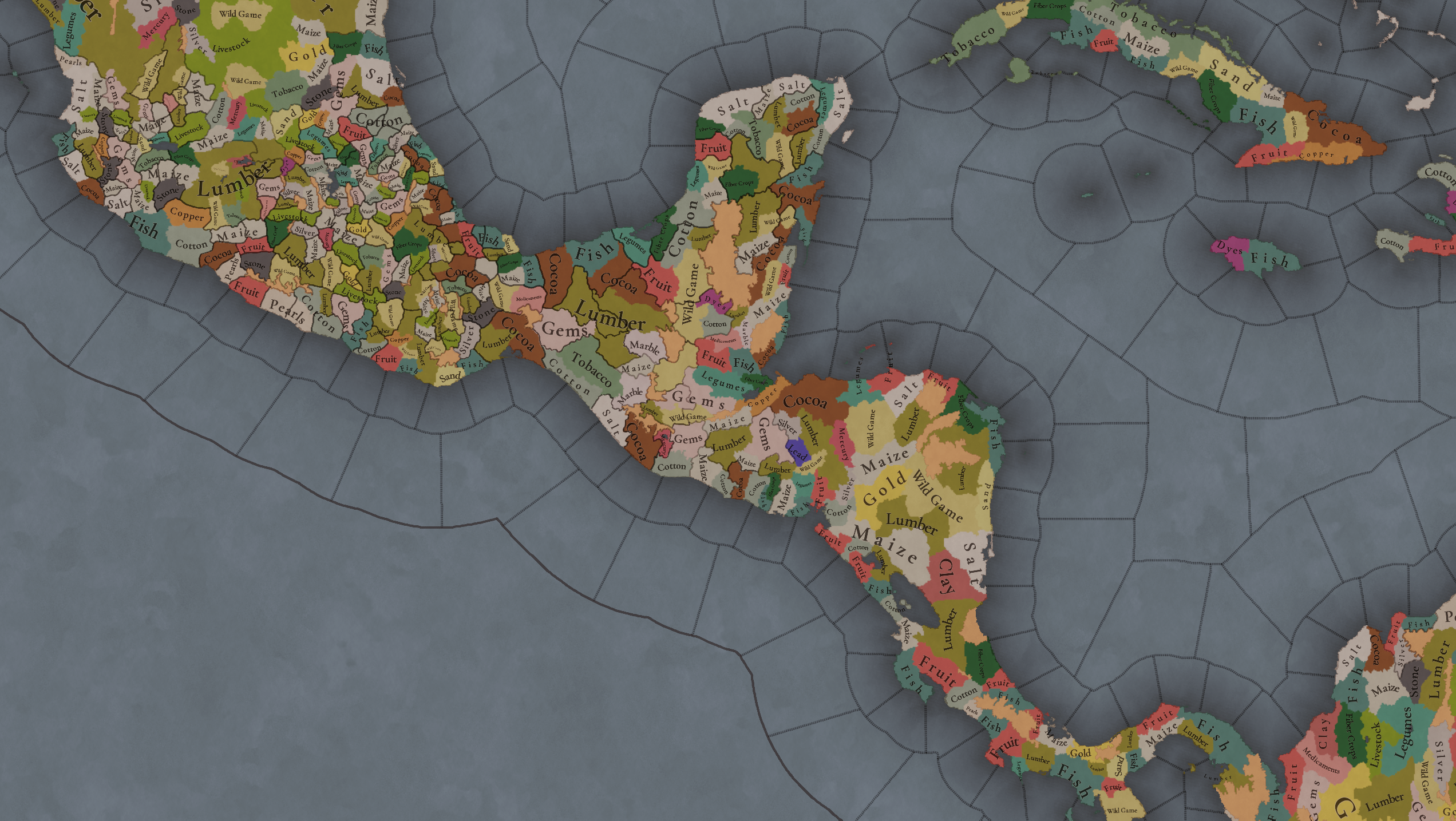
Maize is king in Mesoamerica, although there are plenty of other resources, including juicy Gold and Silver. Obsidian is not a separate resource, as it’s too regional-specific, so it’s included under the Gem coverage, but we have ways to represent it in-game; for instance, there’s a production method to produce Weaponry using Gems as an input.

Markets
Markets.png

A couple of bugs were reported while taking the screenshot of this map! But well, you can see that Azcapotzalco, Màayapáan, and Noh Petén (capital of the Itza people) are the most important ones.

Population
Population1.png

Population2.png

Population3.png

Population4.png

Population5.png

Population6.png

Population7.png

We have solved a couple of issues with the pop editor, and this week this map is in a decent state to be shown! Yay! Total numbers in the region are roughly 8.6M pops, distributed this way:
  • 523K in Aridoamerica (includes the lands to the North-West of the Purepecha Empire)
  • 6.947M in Mesoamerica (including North-Western Mayan lands)
  • 1.003M in Central America (including South-Eastern Mayan lands)
  • 151K in the Caribbean Islands

And that’s all for today! We hope you enjoyed these meaty maps! Next week we will be taking a look at the Levant Feedback, on Monday 16th, and South America, on Friday 20th! Cheers!
 
  • 113Like
  • 95Love
  • 5
  • 1
Reactions:
  • 7Like
Reactions:
Just one thing, the Hispaniola at that time was divided into 5 Chiefdoms. Perhaps in the provinces it would be convenient to divide it according to the way in which those chiefdoms were, they were even more or less small nations because they were aware of what their territory was and even had conflicts over them
 
  • 5Like
Reactions:
I know this is pretty late, but can anyone confirm the political map of the Yucatan peninsula is accurate? At the moment of contact the peninsula was considerably more fractured, with ~9 more entities than paradox's version of 1337. I figure this must be partially due to the instability resulting from the collapse of the League of Mayapan, but I don't know much specifics. I do hope these additional entities will be revolter tags.

1735311587597.png
 
  • 3Like
  • 1
Reactions:
Suggestions for Caribbean Islands:

The following maps represent my suggestions for the Caribbean island's region, special thanks to @Captain_Leo and the redditor by the name of Unhappy-Kangaroo1933 for letting me use their suggestions on Cuba and Puerto Rico. Inside each detailed look, I explained a bit of my thinking when redesigning the maps.

Before continuing I would like to disclaim that I focused the most on the Hispaniola Island, if you have any suggestions for Cuba, Jamaica or Puerto Rico please let me know and I will try to enrich this post by adding it. also, I would like to show this topographic map of Hispaniola, it might shed some light into the decision I made while designing the feedback.

1735327047388.png

Countries:
1735319227165.png

Here the idea was to represent the Taino Chiefdoms as they might have looked 100 years before their Apex, reduced to their core locations while still maintaining borders with each other for gameplay purposes, I have already explained at length why I think that Taino Cacicazgos should be represented as settled states, however in this map I have added the Guainía Cacicazgo who by the time of contact had a tenuous control over the entire island being led by Agueybana, by now however it is confined to its core territory.
1735324428351.png
1735324571434.png
Societies of POP's:
1735320032041.png

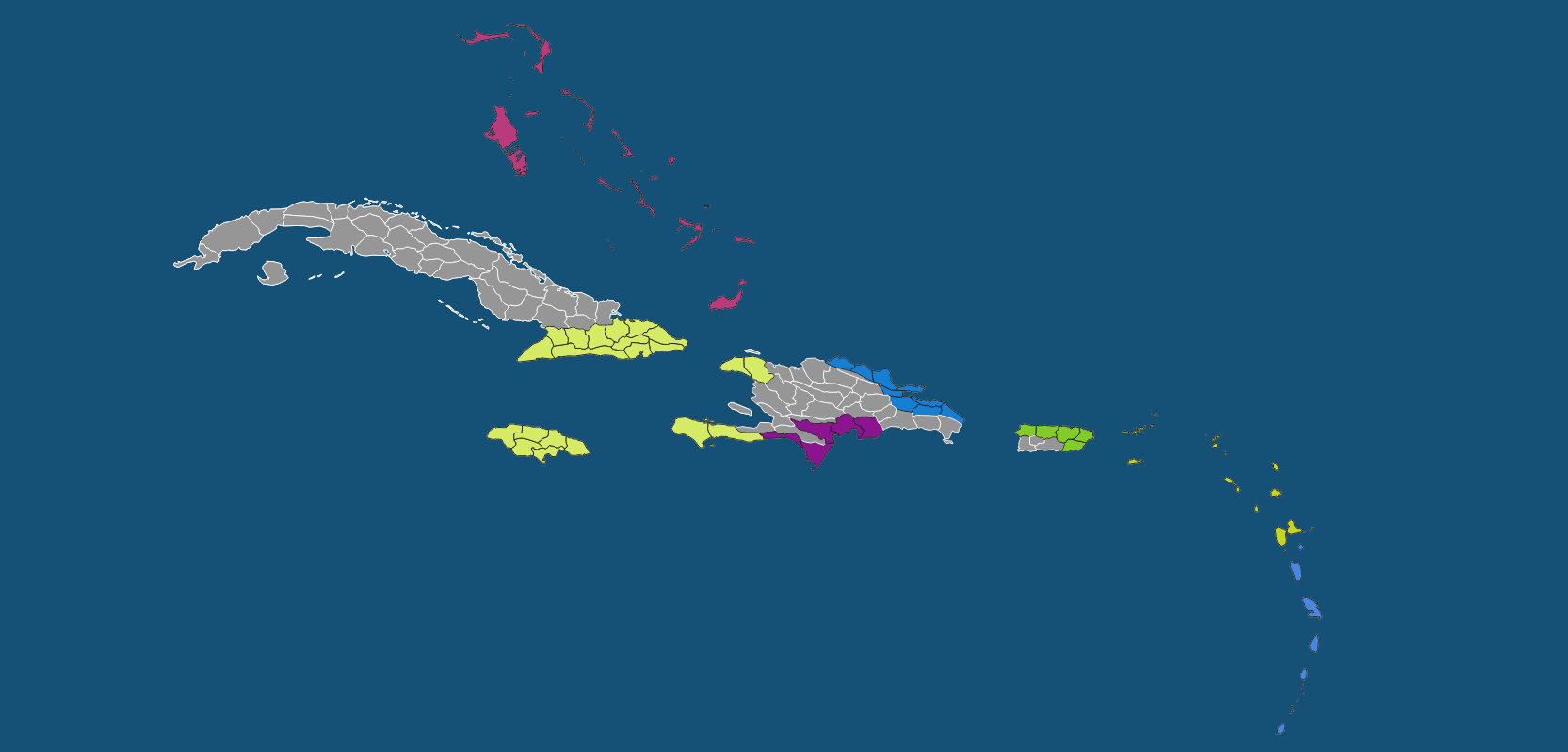
Here we have the societies on the periphery of the Taino cultural complex. again, this is an attempt to represent the state of the region a century prior to contact, we can see that the Tainos of Hispaniola have not yet completely displaced their predecessors, with a strong ciguayo influence on the north eastern part of Hispaniola and a sizeable Macorix hold on the southern part of the island, finally to the West we have the Ciboney SoP, here i have removed the Taino from eastern cuba with the rationale being that if they haven't completely gotten a hold of the main island they probably have not yet expanded to cuba, however the Ciboney have already started to be influenced by the Taino Culture. Lastly, we have a Lacayo SoP in the Bahamas, an Igneri SoP in the northern Lesser Antilles and the feared Carib SoP making their way north through the southern Lesser Antilles.
1735324623507.png

1735325429220.png

Locations:
1735320568379.png

*NOTE: The Bahamas and Lesser Antilles appear black because no changes were made to their setup, the other black shapes on Hispaniola and Puerto Rico are to be interpreted as Wastelands.

A few more locations were added to the map and here I want to stop a little to talk on the topic of density, I want to start by saying that the Caribbean was the first big theater of colonization, it was the forger of the Spanish colonial empire and was so lucrative and attractive that many wars were fought for control over its important islands, bays and ports, it did not only linked commercially Europe to the Americas but was also a tremendous source of income on its own as evidenced by France exploitation of Haiti, with such an important role to play in the game timeframe I consider that the regions deserves a dense number of locations, even more when (and acknowledging that comparisons are ugly) places like Hokkaido, that remained underdeveloped and under populated through the entirety of the game time frame received 59 location while measuring 83,424 km2, meanwhile Hispaniola measuring 76,192 km2 and playing a way more important role gets 22 locations under the current setup, My proposal bumps that number to 38.

1735324710688.png

1735325875849.png

1735326410118.png
Provinces:
1735327326511.png

Here most of the provinces remained the same, just reduced the number of provinces in Hispaniola and rearranged them a little.
1735324826932.png

1735325906709.png


1735326428995.png

Climate:
1735321906376.png

Most locations remained Tropical, with the only exception of extending the Arid climate in south Hispaniola and adding oceanic to the mountain location of Jarabacoa.
1735324925451.png


I don't think it's necessary to show that Cuba is all tropical :p

Topography:
1735322033577.png

This map remains mostly the same while assigning appropriate geography to the newly added locations.
1735325023176.png

1735325983852.png

1735326445401.png

Vegetation:
1735322130886.png

Mostly the same, added more sparse locations to Hispaniola and a few Woods.
1735325096702.png

1735326001066.png

1735326535598.png

Natural Harbors:
1735322245680.png

I tried to keep it mostly the same as the original which is hard without exact values for each location while adding ports in Bayadajabon, and some places in Cuba.
1735325123992.png

1735326021983.png

1735326554148.png

Cultures:
1735322371281.png

As I explained before i am attempting to represent the regions a century before documented history, that's why there is no Taino culture majority yet in eastern Cuba, probably. Guanahatabey could be expanded further east by this logic, would accept recommendations on that.
1735325172353.png

1735326055661.png

1735326572598.png

Languages:
1735322553082.png

No big changes here other than the name of the language being changed from Ta-Arawak to Tainonaiki and my earnest recommendation to separate it from the mainland Arawak language.
[Insert Closer Look]

Dialects:
1735322681648.png

The original map did not include the dialects, however i took the liberty of creating this draft with my proposed division for the Tainonaiki language. I am aware that Macorix and Ciguayo were technically not the same language as taino, but i think that between not having them at all and having them as a dialect of a language that they widely coexisted with I think the lattter is a better option.
1735325273089.png

1735326144345.png

1735326594921.png

RGO's:
1735322901972.png

Mostly adding appropriate resources to each newly added location, some eyebrows might be raised by the presence of Iron on Cuba and Hispaniola, and while yes, the Taino never developed ironworking there are large deposits of iron that were commercially exploited in the past such as in the case of Cuba and that are commercially exploited to this day as is the case of the Falcondo Iron mine in the Dominican Republic which is also the only currently active iron mine in any of the Caribbean islands, and seeing how iron is currently present in the Appalachian mountains according to the tinto map of north America I thought t fitting to place iron here.
Yu can probably notice that I focused on Hispaniola when drawing up the resource map, if you have any suggestions for Cuba, Puerto Rico or Jamaica please do share.
1735325332866.png

1735326168666.png

1735326612012.png

Population:
1735323348830.png

This map represents the amount of people living in each province with brighter colors equating to more people, however it is adjusted to the region so even if locations in Hispaniola are more populated than those in Cuba they are still much bellow the average of locations in Mesoamerica.

Population of the pre-Columbian Caribbean it's a very contentious topic, as it is with the rest of the Americas, serious Estimates have range from tens of thousands to the low millions, a recent DNA study called “A genetic history of the pre-contact Caribbean” Directed by David Reich placed the number at around 50k for Hispaniola alone, however the researchers fail to specify to which approximate time this estimate might be valid for, The wide variety of sample data spanning millennia in Radiocarbon samples combined with the clustering of samples around 1000CE lead us to the assumption that the number is at best a representation of the population around the first millennium and at worst an average of the population between 3,100 to 400 Years Before Present, until new research refines this number I will go on with the assumption that it refers to the population around 1000CE and with the help of the historiographical approach used by Massimo Livi-Bacci in "Return to Hispaniola: Reassessing a Demographic Catastrophe" I think we can confidently place the number at the time of contact in around 300k and extrapolating to a century before I.E the start of the game this number could have been closer to 150k which was my aim for Hispaniola in this population map.
1735325375406.png

1735326209014.png

1735326631275.png

Finally, I am aware that not all my feedback may make it to the final cut, but if only one thing can make it let it be this:

Please divide the giant Ciguayo Location into at least 3 locations, and azua into at least 2.

Thank you.

Also, if the IGS Shapefiles are of use to you, let me know what the best way is of sending them.
 

Attachments

  • 1735321726870.png
    1735321726870.png
    91,7 KB · Views: 0
  • 1735322801035.png
    1735322801035.png
    92 KB · Views: 0
Last edited:
  • 10Like
  • 8Love
  • 5
  • 3
Reactions:
with the help of the historiographical approach used by Massimo Livi-Bacci in "Return to Hispaniola: Reassessing a Demographic Catastrophe" I think we can confidently place the number at the time of contact in around 300k and extrapolating to a century before I.E the start of the game this number could have been closer to 150k which was my aim for Hispaniola in this population map.
While I love the rest of your proposal, a population doubling in a century and a half sounds far too great an increase for a preindustrial society.
 
  • 2Like
  • 2
Reactions:
While I love the rest of your proposal, a population doubling in a century and a half sounds far too great an increase for a preindustrial society.
Yeah, I admit that my numbers might be a little off, but assuming a starting population of 50K with 0.25% sustained growth yearly and in a period of 350 years (1000CE to 1350CE) we still end up with 119,813 people. I might have over shoot a little but it's still double that the current proposal.

In any case my main concern is that Hispaniola should have a higher population than Cuba and the surrounding Islands given the extent and sofistication of agriculture practiced in the island.
 
Why are the Purepecha called purhepecherio?

Also, when it comes to the language dynamics, will it be the same as in EU4 where where there are similar culture groups as there are language groups? I ask as I've heard that linguistically, the Purepecha language is considered a language isolate. [1]

lastly, will advancing technologically be the same as in EU4 where you must unlock feudalism and so on before advancing, else it would make tech more expensive. I don't think this would be really fair for the natives in the Americas, since they never truly embraced/practiced Feudalism.
 
Suggestions for Caribbean Islands:

The following maps represent my suggestions for the Caribbean island's region, special thanks to @Captain_Leo and the redditor by the name of Unhappy-Kangaroo1933 for letting me use their suggestions on Cuba and Puerto Rico. Inside each detailed look, I explained a bit of my thinking when redesigning the maps.

Before continuing I would like to disclaim that I focused the most on the Hispaniola Island, if you have any suggestions for Cuba, Jamaica or Puerto Rico please let me know and I will try to enrich this post by adding it. also, I would like to show this topographic map of Hispaniola, it might shed some light into the decision I made while designing the feedback.

View attachment 1236554
Countries:
View attachment 1236434

Here the idea was to represent the Taino Chiefdoms as they might have looked 100 years before their Apex, reduced to their core locations while still maintaining borders with each other for gameplay purposes, I have already explained at length why I think that Taino Cacicazgos should be represented as settled states, however in this map I have added the Guainía Cacicazgo who by the time of contact had a tenuous control over the entire island being led by Agueybana, by now however it is confined to its core territory.
View attachment 1236485View attachment 1236486
Societies of POP's:
View attachment 1236436
Here we have the societies on the periphery of the Taino cultural complex. again, this is an attempt to represent the state of the region a century prior to contact, we can see that the Tainos of Hispaniola have not yet completely displaced their predecessors, with a strong ciguayo influence on the north eastern part of Hispaniola and a sizeable Macorix hold on the southern part of the island, finally to the West we have the Ciboney SoP, here i have removed the Taino from eastern cuba with the rationale being that if they haven't completely gotten a hold of the main island they probably have not yet expanded to cuba, however the Ciboney have already started to be influenced by the Taino Culture. Lastly, we have a Lacayo SoP in the Bahamas, an Igneri SoP in the northern Lesser Antilles and the feared Carib SoP making their way north through the southern Lesser Antilles.
View attachment 1236488
View attachment 1236522

Locations:
View attachment 1236440
*NOTE: The Bahamas and Lesser Antilles appear black because no changes were made to their setup, the other black shapes on Hispaniola and Puerto Rico are to be interpreted as Wastelands.

A few more locations were added to the map and here I want to stop a little to talk on the topic of density, I want to start by saying that the Caribbean was the first big theater of colonization, it was the forger of the Spanish colonial empire and was so lucrative and attractive that many wars were fought for control over its important islands, bays and ports, it did not only linked commercially Europe to the Americas but was also a tremendous source of income on its own as evidenced by France exploitation of Haiti, with such an important role to play in the game timeframe I consider that the regions deserves a dense number of locations, even more when (and acknowledging that comparisons are ugly) places like Hokkaido, that remained underdeveloped and under populated through the entirety of the game time frame received 59 location while measuring 83,424 km2, meanwhile Hispaniola measuring 76,192 km2 and playing a way more important role gets 22 locations under the current setup, My proposal bumps that number to 38.

View attachment 1236490
View attachment 1236528
View attachment 1236541
Provinces:
View attachment 1236556
Here most of the provinces remained the same, just reduced the number of provinces in Hispaniola and rearranged them a little.
View attachment 1236493
View attachment 1236529

View attachment 1236542

Climate:
View attachment 1236452
Most locations remained Tropical, with the only exception of extending the Arid climate in south Hispaniola and adding oceanic to the mountain location of Jarabacoa.
View attachment 1236496

I don't think it's necessary to show that Cuba is all tropical :p

Topography:
View attachment 1236454
This map remains mostly the same while assigning appropriate geography to the newly added locations.
View attachment 1236504
View attachment 1236532
View attachment 1236543

Vegetation:
View attachment 1236455
Mostly the same, added more sparse locations to Hispaniola and a few Woods.
View attachment 1236507
View attachment 1236534
View attachment 1236544

Natural Harbors:
View attachment 1236456
I tried to keep it mostly the same as the original which is hard without exact values for each location while adding ports in Bayadajabon, and some places in Cuba.
View attachment 1236510
View attachment 1236535
View attachment 1236545

Cultures:
View attachment 1236457
As I explained before i am attempting to represent the regions a century before documented history, that's why there is no Taino culture majority yet in eastern Cuba, probably. Guanahatabey could be expanded further east by this logic, would accept recommendations on that.
View attachment 1236512
View attachment 1236537
View attachment 1236546

Languages:
View attachment 1236459
No big changes here other than the name of the language being changed from Ta-Arawak to Tainonaiki and my earnest recommendation to separate it from the mainland Arawak language.
[Insert Closer Look]

Dialects:
View attachment 1236464
The original map did not include the dialects, however i took the liberty of creating this draft with my proposed division for the Tainonaiki language. I am aware that Macorix and Ciguayo were technically not the same language as taino, but i think that between not having them at all and having them as a dialect of a language that they widely coexisted with I think the lattter is a better option.
View attachment 1236514
View attachment 1236538
View attachment 1236547

RGO's:
View attachment 1236467
Mostly adding appropriate resources to each newly added location, some eyebrows might be raised by the presence of Iron on Cuba and Hispaniola, and while yes, the Taino never developed ironworking there are large deposits of iron that were commercially exploited in the past such as in the case of Cuba and that are commercially exploited to this day as is the case of the Falcondo Iron mine in the Dominican Republic which is also the only currently active iron mine in any of the Caribbean islands, and seeing how iron is currently present in the Appalachian mountains according to the tinto map of north America I thought t fitting to place iron here.
Yu can probably notice that I focused on Hispaniola when drawing up the resource map, if you have any suggestions for Cuba, Puerto Rico or Jamaica please do share.
View attachment 1236516
View attachment 1236539
View attachment 1236548

Population:
View attachment 1236468
This map represents the amount of people living in each province with brighter colors equating to more people, however it is adjusted to the region so even if locations in Hispaniola are more populated than those in Cuba they are still much bellow the average of locations in Mesoamerica.

Population of the pre-Columbian Caribbean it's a very contentious topic, as it is with the rest of the Americas, serious Estimates have range from tens of thousands to the low millions, a recent DNA study called “A genetic history of the pre-contact Caribbean” Directed by David Reich placed the number at around 50k for Hispaniola alone, however the researchers fail to specify to which approximate time this estimate might be valid for, The wide variety of sample data spanning millennia in Radiocarbon samples combined with the clustering of samples around 1000CE lead us to the assumption that the number is at best a representation of the population around the first millennium and at worst an average of the population between 3,100 to 400 Years Before Present, until new research refines this number I will go on with the assumption that it refers to the population around 1000CE and with the help of the historiographical approach used by Massimo Livi-Bacci in "Return to Hispaniola: Reassessing a Demographic Catastrophe" I think we can confidently place the number at the time of contact in around 300k and extrapolating to a century before I.E the start of the game this number could have been closer to 150k which was my aim for Hispaniola in this population map.
View attachment 1236520
View attachment 1236540
View attachment 1236550

Finally, I am aware that not all my feedback may make it to the final cut, but if only one thing can make it let it be this:

Please divide the giant Ciguayo Location into at least 3 locations, and azua into at least 2.

Thank you.

Also, if the IGS Shapefiles are of use to you, let me know what the best way is of sending them.
Did anybody correct the name of Hispaniola to Quisqueya before? Or is it not a valid native name for the whole Hispaniola island?
 
  • 1Like
Reactions:
Suggestions for Caribbean Islands:

The following maps represent my suggestions for the Caribbean island's region, special thanks to @Captain_Leo and the redditor by the name of Unhappy-Kangaroo1933 for letting me use their suggestions on Cuba and Puerto Rico. Inside each detailed look, I explained a bit of my thinking when redesigning the maps.

Before continuing I would like to disclaim that I focused the most on the Hispaniola Island, if you have any suggestions for Cuba, Jamaica or Puerto Rico please let me know and I will try to enrich this post by adding it. also, I would like to show this topographic map of Hispaniola, it might shed some light into the decision I made while designing the feedback.

View attachment 1236554
Countries:
View attachment 1236434

Here the idea was to represent the Taino Chiefdoms as they might have looked 100 years before their Apex, reduced to their core locations while still maintaining borders with each other for gameplay purposes, I have already explained at length why I think that Taino Cacicazgos should be represented as settled states, however in this map I have added the Guainía Cacicazgo who by the time of contact had a tenuous control over the entire island being led by Agueybana, by now however it is confined to its core territory.
View attachment 1236485View attachment 1236486
Societies of POP's:
View attachment 1236436
Here we have the societies on the periphery of the Taino cultural complex. again, this is an attempt to represent the state of the region a century prior to contact, we can see that the Tainos of Hispaniola have not yet completely displaced their predecessors, with a strong ciguayo influence on the north eastern part of Hispaniola and a sizeable Macorix hold on the southern part of the island, finally to the West we have the Ciboney SoP, here i have removed the Taino from eastern cuba with the rationale being that if they haven't completely gotten a hold of the main island they probably have not yet expanded to cuba, however the Ciboney have already started to be influenced by the Taino Culture. Lastly, we have a Lacayo SoP in the Bahamas, an Igneri SoP in the northern Lesser Antilles and the feared Carib SoP making their way north through the southern Lesser Antilles.
View attachment 1236488
View attachment 1236522

Locations:
View attachment 1236440
*NOTE: The Bahamas and Lesser Antilles appear black because no changes were made to their setup, the other black shapes on Hispaniola and Puerto Rico are to be interpreted as Wastelands.

A few more locations were added to the map and here I want to stop a little to talk on the topic of density, I want to start by saying that the Caribbean was the first big theater of colonization, it was the forger of the Spanish colonial empire and was so lucrative and attractive that many wars were fought for control over its important islands, bays and ports, it did not only linked commercially Europe to the Americas but was also a tremendous source of income on its own as evidenced by France exploitation of Haiti, with such an important role to play in the game timeframe I consider that the regions deserves a dense number of locations, even more when (and acknowledging that comparisons are ugly) places like Hokkaido, that remained underdeveloped and under populated through the entirety of the game time frame received 59 location while measuring 83,424 km2, meanwhile Hispaniola measuring 76,192 km2 and playing a way more important role gets 22 locations under the current setup, My proposal bumps that number to 38.

View attachment 1236490
View attachment 1236528
View attachment 1236541
Provinces:
View attachment 1236556
Here most of the provinces remained the same, just reduced the number of provinces in Hispaniola and rearranged them a little.
View attachment 1236493
View attachment 1236529

View attachment 1236542

Climate:
View attachment 1236452
Most locations remained Tropical, with the only exception of extending the Arid climate in south Hispaniola and adding oceanic to the mountain location of Jarabacoa.
View attachment 1236496

I don't think it's necessary to show that Cuba is all tropical :p

Topography:
View attachment 1236454
This map remains mostly the same while assigning appropriate geography to the newly added locations.
View attachment 1236504
View attachment 1236532
View attachment 1236543

Vegetation:
View attachment 1236455
Mostly the same, added more sparse locations to Hispaniola and a few Woods.
View attachment 1236507
View attachment 1236534
View attachment 1236544

Natural Harbors:
View attachment 1236456
I tried to keep it mostly the same as the original which is hard without exact values for each location while adding ports in Bayadajabon, and some places in Cuba.
View attachment 1236510
View attachment 1236535
View attachment 1236545

Cultures:
View attachment 1236457
As I explained before i am attempting to represent the regions a century before documented history, that's why there is no Taino culture majority yet in eastern Cuba, probably. Guanahatabey could be expanded further east by this logic, would accept recommendations on that.
View attachment 1236512
View attachment 1236537
View attachment 1236546

Languages:
View attachment 1236459
No big changes here other than the name of the language being changed from Ta-Arawak to Tainonaiki and my earnest recommendation to separate it from the mainland Arawak language.
[Insert Closer Look]

Dialects:
View attachment 1236464
The original map did not include the dialects, however i took the liberty of creating this draft with my proposed division for the Tainonaiki language. I am aware that Macorix and Ciguayo were technically not the same language as taino, but i think that between not having them at all and having them as a dialect of a language that they widely coexisted with I think the lattter is a better option.
View attachment 1236514
View attachment 1236538
View attachment 1236547

RGO's:
View attachment 1236467
Mostly adding appropriate resources to each newly added location, some eyebrows might be raised by the presence of Iron on Cuba and Hispaniola, and while yes, the Taino never developed ironworking there are large deposits of iron that were commercially exploited in the past such as in the case of Cuba and that are commercially exploited to this day as is the case of the Falcondo Iron mine in the Dominican Republic which is also the only currently active iron mine in any of the Caribbean islands, and seeing how iron is currently present in the Appalachian mountains according to the tinto map of north America I thought t fitting to place iron here.
Yu can probably notice that I focused on Hispaniola when drawing up the resource map, if you have any suggestions for Cuba, Puerto Rico or Jamaica please do share.
View attachment 1236516
View attachment 1236539
View attachment 1236548

Population:
View attachment 1236468
This map represents the amount of people living in each province with brighter colors equating to more people, however it is adjusted to the region so even if locations in Hispaniola are more populated than those in Cuba they are still much bellow the average of locations in Mesoamerica.

Population of the pre-Columbian Caribbean it's a very contentious topic, as it is with the rest of the Americas, serious Estimates have range from tens of thousands to the low millions, a recent DNA study called “A genetic history of the pre-contact Caribbean” Directed by David Reich placed the number at around 50k for Hispaniola alone, however the researchers fail to specify to which approximate time this estimate might be valid for, The wide variety of sample data spanning millennia in Radiocarbon samples combined with the clustering of samples around 1000CE lead us to the assumption that the number is at best a representation of the population around the first millennium and at worst an average of the population between 3,100 to 400 Years Before Present, until new research refines this number I will go on with the assumption that it refers to the population around 1000CE and with the help of the historiographical approach used by Massimo Livi-Bacci in "Return to Hispaniola: Reassessing a Demographic Catastrophe" I think we can confidently place the number at the time of contact in around 300k and extrapolating to a century before I.E the start of the game this number could have been closer to 150k which was my aim for Hispaniola in this population map.
View attachment 1236520
View attachment 1236540
View attachment 1236550

Finally, I am aware that not all my feedback may make it to the final cut, but if only one thing can make it let it be this:

Please divide the giant Ciguayo Location into at least 3 locations, and azua into at least 2.

Thank you.

Also, if the IGS Shapefiles are of use to you, let me know what the best way is of sending them.
Sorry of being pedantic:
"Population of the pre-Columbian Caribbean it's a very contentious topic, as it is with the rest of the Americas, serious Estimates have range from tens of thousands to the low millions, a recent DNA study called “A genetic history of the pre-contact Caribbean” Directed by David Reich placed the number at around 50k for Hispaniola alone"

To clarify the range was 1500 to 81500 based on aggregating the lower and upper bound estimate of the effective population and then applying a x3 to x10 multiple on that to estimate census population and the number included Puerto Rico.
 
  • 2Like
Reactions:
No big changes here other than the name of the language being changed from Ta-Arawak to Tainonaiki and my earnest recommendation to separate it from the mainland Arawak language.
I'd prefer to have Guanahatabey and Macorix be counted as the Warao language and Ciguayo as the Tolupan language, rather than grouping them as Taino. That's comparative linguistics' best guess as to their affiliations.

"Mainland Arawak" is a bit imprecise, as Wayuu, Caquetio and Lokono are all Ta-Arawakan and fairly closely related to the erstwhile Taino language.

Finally, as noted elsewhere the Island Caribs were Ta-Arawakan speakers with a Carib superstrate.
 
  • 2Like
Reactions:
Did anybody correct the name of Hispaniola to Quisqueya before? Or is it not a valid native name for the whole Hispaniola island?
While I do like the name of Quisqueya i was hesitant to include it because of controversies surrounding it, evidence appears to show that the name was likely an early Spanish chronicler fabrication rather than actual name used by the Taino People, that being said,

That being said the term has become synonymous with the indigenous past of the island and its supposed to represent the entire island instead of just he western mountainous half that is called Haiti, So I would not oppose to it (Quisqueya) being used instead of Hispaniola. I even think that if you unify the island as the taino that should be the formable tag name.


Sorry of being pedantic:
"Population of the pre-Columbian Caribbean it's a very contentious topic, as it is with the rest of the Americas, serious Estimates have range from tens of thousands to the low millions, a recent DNA study called “A genetic history of the pre-contact Caribbean” Directed by David Reich placed the number at around 50k for Hispaniola alone"

To clarify the range was 1500 to 81500 based on aggregating the lower and upper bound estimate of the effective population and then applying a x3 to x10 multiple on that to estimate census population and the number included Puerto Rico.
Not pedantic at all my friend, thanks for clarifying, would you suggest any specific changes to the population number map?


I'd prefer to have Guanahatabey and Macorix be counted as the Warao language and Ciguayo as the Tolupan language, rather than grouping them as Taino. That's comparative linguistics' best guess as to their affiliations.

"Mainland Arawak" is a bit imprecise, as Wayuu, Caquetio and Lokono are all Ta-Arawakan and fairly closely related to the erstwhile Taino language.

Finally, as noted elsewhere the Island Caribs were Ta-Arawakan speakers with a Carib superstrate.
Good Idea to include Guanahatabey and Macorix as Warao will try to update the maps soon, regarding Ciguayo, I don't see the Tolupan language on the language map, I think it's from around the honduras Area? if it's represented with another name in the maps, please let me know to do the appropriate correction.

Indeed, mainland Arawak might not be the best naming convention, and yes, Taino and its related languages are part of the Ta-Arawak family, however according to tinto maps on south America they are using the name Ta-Arawak for all the Arawak languages instead of only the northern variants, I just would suggest that they call the language Arawak if they plan to use it for the whole continent or try to use less synthetic names than for example Ta-Arawak if they want to subdivide it into the subfamilies.
 
  • 2Like
Reactions:
Good Idea to include Guanahatabey and Macorix as Warao will try to update the maps soon, regarding Ciguayo, I don't see the Tolupan language on the language map, I think it's from around the honduras Area? if it's represented with another name in the maps, please let me know to do the appropriate correction.
Yep, it's the central Honduras coast, currently considered the "Hokan" language (a controversial hypothesis).
Indeed, mainland Arawak might not be the best naming convention, and yes, Taino and its related languages are part of the Ta-Arawak family, however according to tinto maps on south America they are using the name Ta-Arawak for all the Arawak languages instead of only the northern variants, I just would suggest that they call the language Arawak if they plan to use it for the whole continent or try to use less synthetic names than for example Ta-Arawak if they want to subdivide it into the subfamilies.
That's agreeable.
 
  • 2Like
Reactions:
Suggestions for Caribbean Islands:

The following maps represent my suggestions for the Caribbean island's region, special thanks to @Captain_Leo and the redditor by the name of Unhappy-Kangaroo1933 for letting me use their suggestions on Cuba and Puerto Rico. Inside each detailed look, I explained a bit of my thinking when redesigning the maps.

Before continuing I would like to disclaim that I focused the most on the Hispaniola Island, if you have any suggestions for Cuba, Jamaica or Puerto Rico please let me know and I will try to enrich this post by adding it. also, I would like to show this topographic map of Hispaniola, it might shed some light into the decision I made while designing the feedback.

View attachment 1236554
Countries:
View attachment 1236434

Here the idea was to represent the Taino Chiefdoms as they might have looked 100 years before their Apex, reduced to their core locations while still maintaining borders with each other for gameplay purposes, I have already explained at length why I think that Taino Cacicazgos should be represented as settled states, however in this map I have added the Guainía Cacicazgo who by the time of contact had a tenuous control over the entire island being led by Agueybana, by now however it is confined to its core territory.
View attachment 1236485View attachment 1236486
Societies of POP's:
View attachment 1236436
Here we have the societies on the periphery of the Taino cultural complex. again, this is an attempt to represent the state of the region a century prior to contact, we can see that the Tainos of Hispaniola have not yet completely displaced their predecessors, with a strong ciguayo influence on the north eastern part of Hispaniola and a sizeable Macorix hold on the southern part of the island, finally to the West we have the Ciboney SoP, here i have removed the Taino from eastern cuba with the rationale being that if they haven't completely gotten a hold of the main island they probably have not yet expanded to cuba, however the Ciboney have already started to be influenced by the Taino Culture. Lastly, we have a Lacayo SoP in the Bahamas, an Igneri SoP in the northern Lesser Antilles and the feared Carib SoP making their way north through the southern Lesser Antilles.
View attachment 1236488
View attachment 1236522

Locations:
View attachment 1236440
*NOTE: The Bahamas and Lesser Antilles appear black because no changes were made to their setup, the other black shapes on Hispaniola and Puerto Rico are to be interpreted as Wastelands.

A few more locations were added to the map and here I want to stop a little to talk on the topic of density, I want to start by saying that the Caribbean was the first big theater of colonization, it was the forger of the Spanish colonial empire and was so lucrative and attractive that many wars were fought for control over its important islands, bays and ports, it did not only linked commercially Europe to the Americas but was also a tremendous source of income on its own as evidenced by France exploitation of Haiti, with such an important role to play in the game timeframe I consider that the regions deserves a dense number of locations, even more when (and acknowledging that comparisons are ugly) places like Hokkaido, that remained underdeveloped and under populated through the entirety of the game time frame received 59 location while measuring 83,424 km2, meanwhile Hispaniola measuring 76,192 km2 and playing a way more important role gets 22 locations under the current setup, My proposal bumps that number to 38.

View attachment 1236490
View attachment 1236528
View attachment 1236541
Provinces:
View attachment 1236556
Here most of the provinces remained the same, just reduced the number of provinces in Hispaniola and rearranged them a little.
View attachment 1236493
View attachment 1236529

View attachment 1236542

Climate:
View attachment 1236452
Most locations remained Tropical, with the only exception of extending the Arid climate in south Hispaniola and adding oceanic to the mountain location of Jarabacoa.
View attachment 1236496

I don't think it's necessary to show that Cuba is all tropical :p

Topography:
View attachment 1236454
This map remains mostly the same while assigning appropriate geography to the newly added locations.
View attachment 1236504
View attachment 1236532
View attachment 1236543

Vegetation:
View attachment 1236455
Mostly the same, added more sparse locations to Hispaniola and a few Woods.
View attachment 1236507
View attachment 1236534
View attachment 1236544

Natural Harbors:
View attachment 1236456
I tried to keep it mostly the same as the original which is hard without exact values for each location while adding ports in Bayadajabon, and some places in Cuba.
View attachment 1236510
View attachment 1236535
View attachment 1236545

Cultures:
View attachment 1236457
As I explained before i am attempting to represent the regions a century before documented history, that's why there is no Taino culture majority yet in eastern Cuba, probably. Guanahatabey could be expanded further east by this logic, would accept recommendations on that.
View attachment 1236512
View attachment 1236537
View attachment 1236546

Languages:
View attachment 1236459
No big changes here other than the name of the language being changed from Ta-Arawak to Tainonaiki and my earnest recommendation to separate it from the mainland Arawak language.
[Insert Closer Look]

Dialects:
View attachment 1236464
The original map did not include the dialects, however i took the liberty of creating this draft with my proposed division for the Tainonaiki language. I am aware that Macorix and Ciguayo were technically not the same language as taino, but i think that between not having them at all and having them as a dialect of a language that they widely coexisted with I think the lattter is a better option.
View attachment 1236514
View attachment 1236538
View attachment 1236547

RGO's:
View attachment 1236467
Mostly adding appropriate resources to each newly added location, some eyebrows might be raised by the presence of Iron on Cuba and Hispaniola, and while yes, the Taino never developed ironworking there are large deposits of iron that were commercially exploited in the past such as in the case of Cuba and that are commercially exploited to this day as is the case of the Falcondo Iron mine in the Dominican Republic which is also the only currently active iron mine in any of the Caribbean islands, and seeing how iron is currently present in the Appalachian mountains according to the tinto map of north America I thought t fitting to place iron here.
Yu can probably notice that I focused on Hispaniola when drawing up the resource map, if you have any suggestions for Cuba, Puerto Rico or Jamaica please do share.
View attachment 1236516
View attachment 1236539
View attachment 1236548

Population:
View attachment 1236468
This map represents the amount of people living in each province with brighter colors equating to more people, however it is adjusted to the region so even if locations in Hispaniola are more populated than those in Cuba they are still much bellow the average of locations in Mesoamerica.

Population of the pre-Columbian Caribbean it's a very contentious topic, as it is with the rest of the Americas, serious Estimates have range from tens of thousands to the low millions, a recent DNA study called “A genetic history of the pre-contact Caribbean” Directed by David Reich placed the number at around 50k for Hispaniola alone, however the researchers fail to specify to which approximate time this estimate might be valid for, The wide variety of sample data spanning millennia in Radiocarbon samples combined with the clustering of samples around 1000CE lead us to the assumption that the number is at best a representation of the population around the first millennium and at worst an average of the population between 3,100 to 400 Years Before Present, until new research refines this number I will go on with the assumption that it refers to the population around 1000CE and with the help of the historiographical approach used by Massimo Livi-Bacci in "Return to Hispaniola: Reassessing a Demographic Catastrophe" I think we can confidently place the number at the time of contact in around 300k and extrapolating to a century before I.E the start of the game this number could have been closer to 150k which was my aim for Hispaniola in this population map.
View attachment 1236520
View attachment 1236540
View attachment 1236550

Finally, I am aware that not all my feedback may make it to the final cut, but if only one thing can make it let it be this:

Please divide the giant Ciguayo Location into at least 3 locations, and azua into at least 2.

Thank you.

Also, if the IGS Shapefiles are of use to you, let me know what the best way is of sending them.

It looks like you have the wrong location for Macorix?
1735502590296.png


1735502640513.png


from https://en.wikipedia.org/wiki/Macorix_language

1735502611477.png


On the other hand:
1735502741303.png
 
  • 3Like
  • 1
Reactions:
Suggestions for Caribbean Islands:

The following maps represent my suggestions for the Caribbean island's region, special thanks to @Captain_Leo and the redditor by the name of Unhappy-Kangaroo1933 for letting me use their suggestions on Cuba and Puerto Rico. Inside each detailed look, I explained a bit of my thinking when redesigning the maps.

Before continuing I would like to disclaim that I focused the most on the Hispaniola Island, if you have any suggestions for Cuba, Jamaica or Puerto Rico please let me know and I will try to enrich this post by adding it. also, I would like to show this topographic map of Hispaniola, it might shed some light into the decision I made while designing the feedback.

View attachment 1236554
Countries:
View attachment 1236434

Here the idea was to represent the Taino Chiefdoms as they might have looked 100 years before their Apex, reduced to their core locations while still maintaining borders with each other for gameplay purposes, I have already explained at length why I think that Taino Cacicazgos should be represented as settled states, however in this map I have added the Guainía Cacicazgo who by the time of contact had a tenuous control over the entire island being led by Agueybana, by now however it is confined to its core territory.
View attachment 1236485View attachment 1236486
Societies of POP's:
View attachment 1236436
Here we have the societies on the periphery of the Taino cultural complex. again, this is an attempt to represent the state of the region a century prior to contact, we can see that the Tainos of Hispaniola have not yet completely displaced their predecessors, with a strong ciguayo influence on the north eastern part of Hispaniola and a sizeable Macorix hold on the southern part of the island, finally to the West we have the Ciboney SoP, here i have removed the Taino from eastern cuba with the rationale being that if they haven't completely gotten a hold of the main island they probably have not yet expanded to cuba, however the Ciboney have already started to be influenced by the Taino Culture. Lastly, we have a Lacayo SoP in the Bahamas, an Igneri SoP in the northern Lesser Antilles and the feared Carib SoP making their way north through the southern Lesser Antilles.
View attachment 1236488
View attachment 1236522

Locations:
View attachment 1236440
*NOTE: The Bahamas and Lesser Antilles appear black because no changes were made to their setup, the other black shapes on Hispaniola and Puerto Rico are to be interpreted as Wastelands.

A few more locations were added to the map and here I want to stop a little to talk on the topic of density, I want to start by saying that the Caribbean was the first big theater of colonization, it was the forger of the Spanish colonial empire and was so lucrative and attractive that many wars were fought for control over its important islands, bays and ports, it did not only linked commercially Europe to the Americas but was also a tremendous source of income on its own as evidenced by France exploitation of Haiti, with such an important role to play in the game timeframe I consider that the regions deserves a dense number of locations, even more when (and acknowledging that comparisons are ugly) places like Hokkaido, that remained underdeveloped and under populated through the entirety of the game time frame received 59 location while measuring 83,424 km2, meanwhile Hispaniola measuring 76,192 km2 and playing a way more important role gets 22 locations under the current setup, My proposal bumps that number to 38.

View attachment 1236490
View attachment 1236528
View attachment 1236541
Provinces:
View attachment 1236556
Here most of the provinces remained the same, just reduced the number of provinces in Hispaniola and rearranged them a little.
View attachment 1236493
View attachment 1236529

View attachment 1236542

Climate:
View attachment 1236452
Most locations remained Tropical, with the only exception of extending the Arid climate in south Hispaniola and adding oceanic to the mountain location of Jarabacoa.
View attachment 1236496

I don't think it's necessary to show that Cuba is all tropical :p

Topography:
View attachment 1236454
This map remains mostly the same while assigning appropriate geography to the newly added locations.
View attachment 1236504
View attachment 1236532
View attachment 1236543

Vegetation:
View attachment 1236455
Mostly the same, added more sparse locations to Hispaniola and a few Woods.
View attachment 1236507
View attachment 1236534
View attachment 1236544

Natural Harbors:
View attachment 1236456
I tried to keep it mostly the same as the original which is hard without exact values for each location while adding ports in Bayadajabon, and some places in Cuba.
View attachment 1236510
View attachment 1236535
View attachment 1236545

Cultures:
View attachment 1236457
As I explained before i am attempting to represent the regions a century before documented history, that's why there is no Taino culture majority yet in eastern Cuba, probably. Guanahatabey could be expanded further east by this logic, would accept recommendations on that.
View attachment 1236512
View attachment 1236537
View attachment 1236546

Languages:
View attachment 1236459
No big changes here other than the name of the language being changed from Ta-Arawak to Tainonaiki and my earnest recommendation to separate it from the mainland Arawak language.
[Insert Closer Look]

Dialects:
View attachment 1236464
The original map did not include the dialects, however i took the liberty of creating this draft with my proposed division for the Tainonaiki language. I am aware that Macorix and Ciguayo were technically not the same language as taino, but i think that between not having them at all and having them as a dialect of a language that they widely coexisted with I think the lattter is a better option.
View attachment 1236514
View attachment 1236538
View attachment 1236547

RGO's:
View attachment 1236467
Mostly adding appropriate resources to each newly added location, some eyebrows might be raised by the presence of Iron on Cuba and Hispaniola, and while yes, the Taino never developed ironworking there are large deposits of iron that were commercially exploited in the past such as in the case of Cuba and that are commercially exploited to this day as is the case of the Falcondo Iron mine in the Dominican Republic which is also the only currently active iron mine in any of the Caribbean islands, and seeing how iron is currently present in the Appalachian mountains according to the tinto map of north America I thought t fitting to place iron here.
Yu can probably notice that I focused on Hispaniola when drawing up the resource map, if you have any suggestions for Cuba, Puerto Rico or Jamaica please do share.
View attachment 1236516
View attachment 1236539
View attachment 1236548

Population:
View attachment 1236468
This map represents the amount of people living in each province with brighter colors equating to more people, however it is adjusted to the region so even if locations in Hispaniola are more populated than those in Cuba they are still much bellow the average of locations in Mesoamerica.

Population of the pre-Columbian Caribbean it's a very contentious topic, as it is with the rest of the Americas, serious Estimates have range from tens of thousands to the low millions, a recent DNA study called “A genetic history of the pre-contact Caribbean” Directed by David Reich placed the number at around 50k for Hispaniola alone, however the researchers fail to specify to which approximate time this estimate might be valid for, The wide variety of sample data spanning millennia in Radiocarbon samples combined with the clustering of samples around 1000CE lead us to the assumption that the number is at best a representation of the population around the first millennium and at worst an average of the population between 3,100 to 400 Years Before Present, until new research refines this number I will go on with the assumption that it refers to the population around 1000CE and with the help of the historiographical approach used by Massimo Livi-Bacci in "Return to Hispaniola: Reassessing a Demographic Catastrophe" I think we can confidently place the number at the time of contact in around 300k and extrapolating to a century before I.E the start of the game this number could have been closer to 150k which was my aim for Hispaniola in this population map.
View attachment 1236520
View attachment 1236540
View attachment 1236550

Finally, I am aware that not all my feedback may make it to the final cut, but if only one thing can make it let it be this:

Please divide the giant Ciguayo Location into at least 3 locations, and azua into at least 2.

Thank you.

Also, if the IGS Shapefiles are of use to you, let me know what the best way is of sending them.

Good map, I don't think PR has wastelands given the amount of rain it historically gets. If you split the locations like that I would get the maize and fruit out and put in materials that would make building forts easier, as well as salt.
 
  • 1Like
Reactions:
Yeah, the Macorix seem to have primarily occupied the northern part of the island. However, since I’m unsure if SoP’s are allowed to have non-contiguous territory, and the Ciguayo were already inhabiting that area, and because based on the map, the Macorix also appear to have been present in the southern part of the island I decided to represent it this way. If you have a better suggestion for rearranging these societies, I’m open to implementing it.


Good map, I don't think PR has wastelands given the amount of rain it historically gets. If you split the locations like that I would get the maize and fruit out and put in materials that would make building forts easier, as well as salt.
Seems like a good idea, any other specific materials other than salt that come to mind (were there any salt gathering operation in the island historically)? and where would you place them?
 
Yeah, the Macorix seem to have primarily occupied the northern part of the island. However, since I’m unsure if SoP’s are allowed to have non-contiguous territory, and the Ciguayo were already inhabiting that area, and because based on the map, the Macorix also appear to have been present in the southern part of the island I decided to represent it this way. If you have a better suggestion forSiutwes rearranging these societies, I’m open to implementing it.


Seems like a good idea, any other specific materials other than salt that come to mind (were there any salt gathering operation in the island historically)? and where would you place them?
Southwestern PR had salt production and lumber and stone for construction where easy to procure.
 
  • 1
  • 1Like
Reactions: