• We have updated our Community Code of Conduct. Please read through the new rules for the forum that are an integral part of Paradox Interactive’s User Agreement.

Tinto Maps #29 - 13th of December 2024 - Central America

Hello everybody, and welcome to Tinto Maps, the happy Fridays for map lovers! Today, we will be looking at Central America, which includes the Caribbean. Before we start, I want to introduce you @RaulTrullenque , the only member of our Content Design team who had not yet gone public, and who worked really hard on the maps and content of the Central American and South American regions.

And now let’s get started without further ado!

Countries
Countries1.png

Countries2.png

Countries3.png

Countries4.png

Countries5.png

Countries6.png

Countries7.png

Tenochtitlan.png

Mayan.png
Welcome to the Mesoamerican Thunder Dome! This area is characterized by its numerous Altepetl, more or less comparable to city-states. Most of them are ruled in 1337 by peoples of Nahua origin, something that you may see much more clearly in the culture map. The biggest power in this moment is the Empire of P’urhépecherio, though, founded by the Purepecha people. In any case, you may notice that there’s a lot of detail in this area, including a tiny Nahua settlement recently founded on an island over Lake Texcoco, Tenochtitlan. This is the first time in a PDX GSG that we have the island itself present on the map, although the location covers some more land over the lake coast, to make it playable. Finally, we also have the Mayan polities of the Postclassic Period, of which Cocom, with its capital Màayapáan, was the most important, along with others, such as K’iche’ and its capital Q’umarkaj.

SoPs
SoPs1.png

SoPs2.png

SoPs3.png

SoPs4.png
On the outskirts of the Mesoamerican polities, there are plenty of peoples organized on different ways. To the north, we have the ones that populate the area known as Aridoamerica, which were collectively termed by the Nahua as ‘Chichimeca’. We also have plenty of societies close to the Mayan lands and the Isthmus. And, finally, the Taíno people populate some of the biggest islands in the Caribbean.

Locations
Locations1.png

Locations2.png

Locations3.png

Locations4.png

Locations5.png

Locations6.png

Locations7.png

Locations8.png

Plenty of locations here! I just want no note that the Darien Gap is an impassable wasteland, which means that any army trying to cross from modern Panama and Colombia will need transport ships to be able to do it.

Provinces
Provinces1.png

Provinces2.png


Areas
Areas1.png

Areas2.png


Terrain
Climate.png

Climate2.png

Topography.png

Vegetation.png

Vegetation2.png

A very diverse region! Most of it is covered by Tropical Jungles and Forests, but Sierra Madre Occidental and Oriental make for very specific conditions in the Mexican Altiplano, which are not only visible in the Topography map but also in the climate and vegetation of the area.

Development
Development2.png

The most developed regions in Mesoamerica are the Valley of Mexico and the Mayan coastline.

Natural Harbors
Harbors.png

There are some good ports in the Caribbean, no surprise that most of them would later become important cities in the Colonial Period.

Culture
Cultures.png

Cultures2.png

Tons of cultures!

Language
Dominant Languages1.png

Dominant Languages2.png

Court Language.png

And also languages! The first two maps are the Dominant Languages per location, while the third is the Court Languages one. The dark blue language is ‘Totozoquean’, as it is not so easily readable (something we have to change).

Religions
Religions.png

This map is today in a more advanced state, as we have merged plenty of cultural religions into regional groupings. Of these, Tonalism, Nahua, and Mayan are part of the Tonalist religious groups, while the others are part of the Folk American group (a regional split of the former ‘Animist’ group). Nahua and Mayan have their different mechanics, which we’ll talk about in future Tinto Talks. Let us know what do you think of this design and any suggestions about the religious grouping!

Raw Materials
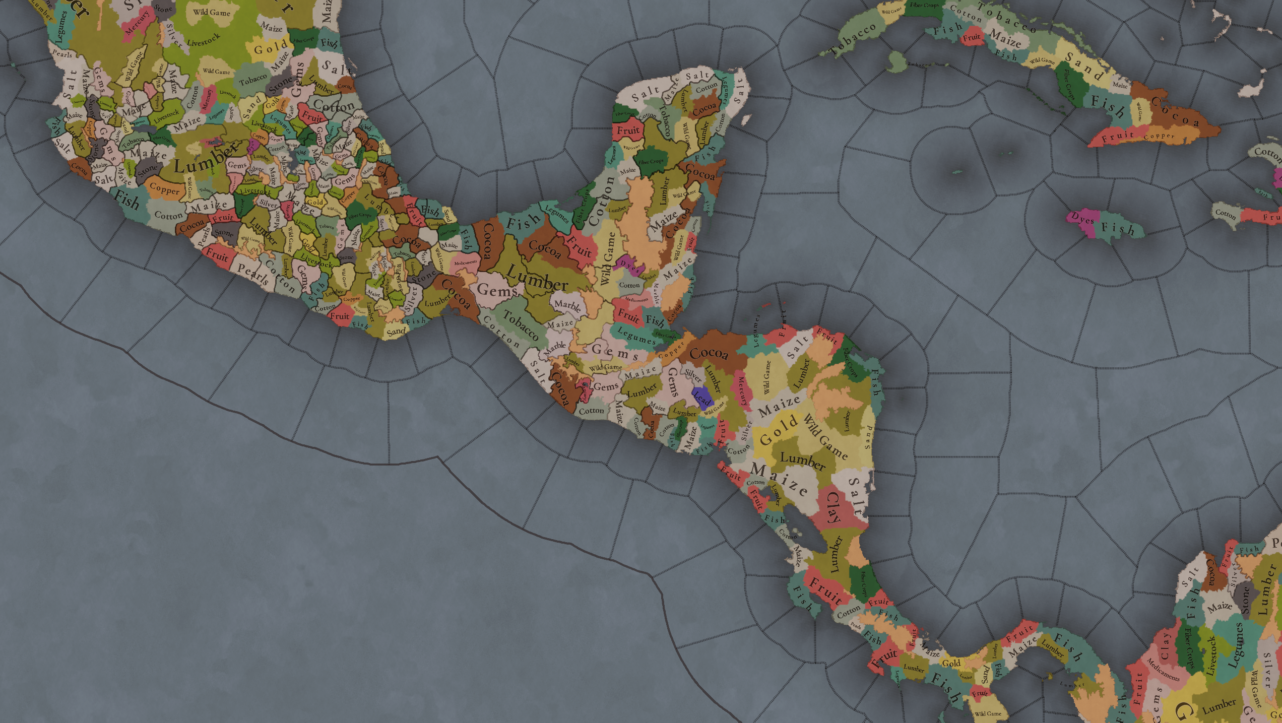
Raw Materials1.png

Raw Materials2.png

Raw Materials3.png

Raw Materials4.png

Maize is king in Mesoamerica, although there are plenty of other resources, including juicy Gold and Silver. Obsidian is not a separate resource, as it’s too regional-specific, so it’s included under the Gem coverage, but we have ways to represent it in-game; for instance, there’s a production method to produce Weaponry using Gems as an input.

Markets
Markets.png

A couple of bugs were reported while taking the screenshot of this map! But well, you can see that Azcapotzalco, Màayapáan, and Noh Petén (capital of the Itza people) are the most important ones.

Population
Population1.png

Population2.png

Population3.png

Population4.png

Population5.png

Population6.png

Population7.png

We have solved a couple of issues with the pop editor, and this week this map is in a decent state to be shown! Yay! Total numbers in the region are roughly 8.6M pops, distributed this way:
  • 523K in Aridoamerica (includes the lands to the North-West of the Purepecha Empire)
  • 6.947M in Mesoamerica (including North-Western Mayan lands)
  • 1.003M in Central America (including South-Eastern Mayan lands)
  • 151K in the Caribbean Islands

And that’s all for today! We hope you enjoyed these meaty maps! Next week we will be taking a look at the Levant Feedback, on Monday 16th, and South America, on Friday 20th! Cheers!
 
  • 112Like
  • 95Love
  • 5
  • 1
Reactions:
I know this was a while ago, but I wanted to ask how you would design the religious map of the region. Would you keep it somewhat ethnicity-based, or make it more regionally-based? For instance, does it make sense for Nahuas of western Mexico to practice the same religion as those from the center? (of course, I know our information is unfortunately pretty severely limited in Jalisco/Colima). And would it be plausible to combine the Nahua religion with the "Tonalist" populations in Oaxaca, or is it too much of a stretch despite the similarities you mention?
From what we see in PC design it seems like "Teotl" is the umbrella grouping for any non-Maya or non-Nahua mesoamerican religions. Personaly I find quite ironic to use the nahua Teotl for non-Nahua peoples and to put the Purepecha inside this group when they were the "less-mesoamerican" of the Mesoamerican religions. But at the same time I empathize with PC devs on the difficulty to objetively give each different mesoamerican culture their own religion (Zapotec, Mixtec, Totonac, etc). So thinking maybe a good option could be to merge "Nahua" into Teotl religion but use a well developed system of major/patron deities.

Under the Patron Deities system the average Mesoamerican civ could pick common deities like Dzahui/Chaac/Tlaloc but also some exclusives unlocked by your culture like Mixcoatl if you are Nahua or even national deities like Huitzilopochtli for specific tags like Mexica(Tenochtitlan-Tlatelolco).

Now If it is properly used even the Maya could be added for a general Mesoamerican system, of course I think devs want some differentitation in the region to keep the negative effects on diplomacy and population management but this can be simulated by an equivalent intra-religion malus from different deities. Not to forget that PC likely would have some mechanic related to ritual war and sacrifice with I guess huge negative effects.
 
  • 3Like
  • 1
Reactions:
From what we see in PC design it seems like "Teotl" is the umbrella grouping for any non-Maya or non-Nahua mesoamerican religions. Personaly I find quite ironic to use the nahua Teotl for non-Nahua peoples and to put the Purepecha inside this group when they were the "less-mesoamerican" of the Mesoamerican religions. But at the same time I empathize with PC devs on the difficulty to objetively give each different mesoamerican culture their own religion (Zapotec, Mixtec, Totonac, etc). So thinking maybe a good option could be to merge "Nahua" into Teotl religion but use a well developed system of major/patron deities.

Under the Patron Deities system the average Mesoamerican civ could pick common deities like Dzahui/Chaac/Tlaloc but also some exclusives unlocked by your culture like Mixcoatl if you are Nahua or even national deities like Huitzilopochtli for specific tags like Mexica(Tenochtitlan-Tlatelolco).

Now If it is properly used even the Maya could be added for a general Mesoamerican system, of course I think devs want some differentitation in the region to keep the negative effects on diplomacy and population management but this can be simulated by an equivalent intra-religion malus from different deities. Not to forget that PC likely would have some mechanic related to ritual war and sacrifice with I guess huge negative effects.
Yeah this makes a lot of sense, I pretty much came to this conclusion as well. It's funny that you say the devs want to keep some religions separate to keep mali on diplomacy, because from my perspective that's a major problem/inaccuracy with paradox's typical approach to pagan/animist religions. I don't see it as realistic for Mexica-Maya relations for example to be negatively affected by differing religions, because there just weren't hard boundaries or essentialism like that. And certainly not to the extent that paradox portrays, where having different religions is going to add to antagonism. If anything, ethnicity itself would be a bigger factor than religion in Mesoamerica.

Though, unified Mesoamerican religion nonwithstanding, I personally think most "animisms" around the world should have high tolerance of one another, but it would be very hard and slow to convert pops outside of your culture. In fact you might need to reform it to create the institutions necessary for large-scale proselytization. And in turn cultural unrest would be an even bigger problem.
 
Last edited:
  • 3Like
  • 2
Reactions:
also here are you talking about the Chichimeca or more like southern Jalisco and Colima? If it is the latter, I would love to know your basis for saying they were utoaztecan (not skeptical, but rather curious).
The majority of the native languages of Nueva Galicia seems to be utoaztecans but we have references of "Otomi" plus Pinome, Xilotlantzinca, etc. Also some indeterminated and dubious toponymies at the coast+south of the region, similar case in Michoacan with Cuauhcomeca (Teco's affinity is object of speculation) and more places at the coast+west of MIchoacan whose proposed nahuatl or purepecha toponymies goes from dubious to kind of forced.

Broadly it seems like the area around Colima was the final reduct of a variety of languages (maybe Otomanguean and/or Purepecha related) by the time of the Spanish conquest.
 
  • 2Like
Reactions:
Adding a little to the suggestion for Western Mexico here are the tags (playable nations) from Sinaloa and Zacatecas:

nations sinaloa zacatecas.png


Tahue Altepemeh. Independent Cuetzalan and Piaxtla are possible but for the region the main state of Culiacan (Culiacán) would be enough. By the way Colhuacan is another option for the name since we already have Culhuacan used for the Altepetl at the Valley of México.

Totorame Altepemeh. At the souther coast of Sinaloa and the northern coast of Nayarit we have the relevant Chiyametlan (Chametla) and Aztatlan (Aztatlán).

Caxcan Altepemeh. For the Caxcans we certainly need Nochistlan (Nochistlán) to be their onw Altepetl controling also Teocaltiche, then leaders like Tenamaztle and Aquano could shine. Also the Altepemeh of Xochipilla (Juchipila) and Tlaltenango (Tlatenapa) need to be playable, under each also Xalpan and Teulichán respectively.

The presented toponymic glyphs should be used to be their emblems/flags, these come from the "Lienzo de Tlaxcala" and for Nochitlan's one from "Codex Telleriano-Remensis".
 
  • 2Like
  • 1Love
  • 1
Reactions:
Language map proposal (representing the dominant language by location):
languages feedback.png


It works on my proposed culture map as a base, so here's that for reference:
cultures feedback labelled 8.0.png


This suggestion is explicitly unrealistic - ie, many of these languages contain varieties that are nowhere close to mutually intelligible. I chose a compromise between realism and game balance, recognizing the issue of scale and because tinto appears to be set upon a reductive approach. At the end of the day, it's a game, not an encyclopedia. For context, many of the individual cultures themselves are complex families of unintelligible varieties, yet I never considered subdividing them because they were historically viewed as unified languages, ignoring their internal diversity. So when I talk about making compromises that sacrifice realism, they are not the "normal" level, but rather even broader groupings which combine diverse peoples/languages that were never seen as the same or even particularly related.

Here are the languages I'm proposing, organized into families. Next to each language are listed the cultures it covers.

Uto-Aztecan family - I have reservations about including this family at all, as the branches seem to bear little resemblance to one another for the most part, excepting Nahuatl and Corachol.
  • Nahuatl: Nahua, Teco, Pipil, Nicarao, Caxcan, Tecuexe. Tlaxcaltec, Toltec if left in, Olmec, Cuyutec, Coixca, Coca if added.
  • Corachol: Huichol, Cora, Zacatecah, Cuachichitl, Sauzas if left in.
  • out of frame languages: Cahita, Hopi, Piman, Numic, Takic, Tarahumara

Oto-Manguean family - I also have reservations about including this family. There are clear typological similarities, but the languages are not close. I don't believe the speakers themselves would have realized the relationship.
  • Otomi: Otomi/"Otomanguean", Xi'oi, Matlatzinca, Tlahuica, Guamar, Iztachichimecah if left in, Jalisco Otomi (as I mentioned before, I have serious doubts about the relationship with the Otomi of Jalisco, but it is conventionally linked after all, and otherwise we would have nowhere to put it)
  • Zapotec: Zapotec, Chatino if added.
  • Mixtec: Mixtec, Amuzgo if added
  • Tlapanec: Me'phaa, Subtiaba if added
  • Mangue: Chorotega, Chiapanec if added. Labelled Chorotega on the map, but Mangue seems to be the better term.
  • Popoloca: Popoloca, Chinantec (this is the one paraphyletic language I am listing, which I do not like to do, but grouping either of these with Otomi or Zapotec feels quite wrong, and I didn't want to leave both as small one-culture languages though that would of course be the most realistic option).

Mayan family
  • Maya: Maaya, Kan Ek', Itza, Mopan, Kowoj
  • K'iche': K'iche', Tz'utujil, Kaqchikel, Q'eqchi', Poqom if added
  • Ch'ol: Ch'ol, Yokot'aanob, Putum, Manche if added, Winik Atel (Tzeltal), Sotz'leb (Tzotzil), Toquegua, Ch'orti', Tojolabal, Q'anjobal
  • Huastec: Teenek, Chicomuceltec if added (this is a small branch, but the most divergent, having been isolated since the very beginning of Mesoamerican history)

A more realistic version would see more diversity in the highlands, separating out the Qʼanjobal-Tojolabal and Mam, and possibly even the Tzotzil-Tzeltal, Poqom and Qʼeqchiʼ. Otherwise though, the cores of these branches were pretty closely knit by Project Caesar standards in the 1300s.

Chibchan family
  • Isthmic: Huetar, Cabecar, Boruca, Naso, Ngabe
  • Votic: Rama, Maleku
  • Pech
  • out of frame languages: Muisca, Tayrona

Isolates (in-game)
  • Purepecha
  • Totonac - opted against putting it in a family with Mixe-Zoque, as the relationship is as of yet unproven, not to mention distant and would be unknown in the period.
  • Mixe-Zoque: Zoque, Mixe, Tapachultec - Realistically would be a small family, but I grouped them together for balance
  • Misumalpan: Miskito, Kukra, Ulwa, Mayangna, Matagalpa - Realistically would be a small family, but I grouped them together for balance
  • Lenca - has no proven/relevant external relationships, thus I separated it from Misumalpan
  • Xinka
  • Huave
  • Cuitlatec: Cuitlatec, Tuxtec, Chumbia, Tepuztec. Cuitlatec is documented, the others are completely undocumented. Cuitlatec is an isolate to the best of our knowledge, and evidently has no external relation of any real relevance. We can't know the affiliation of the others, but these areas did reportedly share many cultural characteristics according to archaeological research, so grouping them together is the best option IMO.
  • Tequistlatec
  • Choco: Cueva. Out of frame: Embera, Waunaan, Quimbaya. Realistically would be a small family, but I grouped them together for balance
  • Tolupan
I didn't break down the Caribbean on the map, but Guanahatabey should be counted as the Warao language, as should Macorix if added. Ciguayo on the other hand should be counted as the Tolupan language. These three were most likely not Arawakan, and these are the best guesses as to their closest relatives.
 
Last edited:
  • 10Like
Reactions:
I chose a compromise between realism and game balance, recognizing the issue of scale and because tinto appears to be set upon a reductive approach. At the end of the day, it's a game, not an encyclopedia.
What downside would breaking up the languages that aren't even made of closely related real life languages have in game balance?
 
What downside would breaking up the languages that aren't even made of closely related real life languages have in game balance?
They previously said they need namelists to be able to create new languages, and many of these are poorly documented. I think they don't want some regions to have tons of small languages that would make them harder to unify. And for all I know more languages is more stress on performance. At the end of the day I saw how broad their design was in this region, and went for a slightly more modest aproach thinking it might have a better chance of being implemented.
 
  • 1Like
Reactions:
They previously said they need namelists to be able to create new languages, and many of these are poorly documented. I think they don't want some regions to have tons of small languages that would make them harder to unify. And for all I know more languages is more stress on performance. At the end of the day I saw how broad their design was in this region, and went for a slightly more modest aproach thinking it might have a better chance of being implemented.
That makes sense, but aside from difficulty unifying those reasons aren't "game balance" just "gameplay".
 
  • 1Like
Reactions:
I believe the Otomi culture should be switched to the Tonalist religion, as their religious system was absolutely more Mesoamerican than Chichimec. The Otomi practiced ritual blood-letting and nagualism (shape-shifting), and their cosmovision was rooted in the characteristic Mesoamerican dualism. The relacion geografica de Queretaro recorded that the local Otomies (which were among those most removed from the core of Mesoamerica) believed in Quetzalcoatl. As far as other deities, they had a fire deity known as Otontecuhtli ("Otomi lord") that had warrior cult characteristics similar to Huitzilopochtli. They worshipped a "old mother" and "old father" who are proposed to be equivalent to Tonantzin and Huehueteotl respectively. Much like the Mexicas, they also believed the universe had several layers and the world had been created and destroyed multiple times before (a la five suns myth). They had a ritual calendar bearing similarities to the major non-Maya Mesoamerican peoples.

Source: https://www.encyclopedia.com/environment/encyclopedias-almanacs-transcripts-and-maps/otomi-religion

1743517780498.png


Really, the Otomi proper are only marginally and imprecisely called Chichimeca, and their culture must be distinguished from the more core Chichimeca (Zacateca, Guachichil, Guamar, Pame, Jonaz) in all aspects:
1743517754034.png

source: Discovering the Chichimeca, Charlotte M. Gradie, The Americas

Side note, if the Otomi are Tonalist the closely related Matlatzinca should be as well, instead of Nahua. Merging Tonalist and Nahua would be a good idea, but consistency is important.

I will add this to my master post, along with the language map.
 
Last edited:
  • 3Like
  • 1
Reactions:
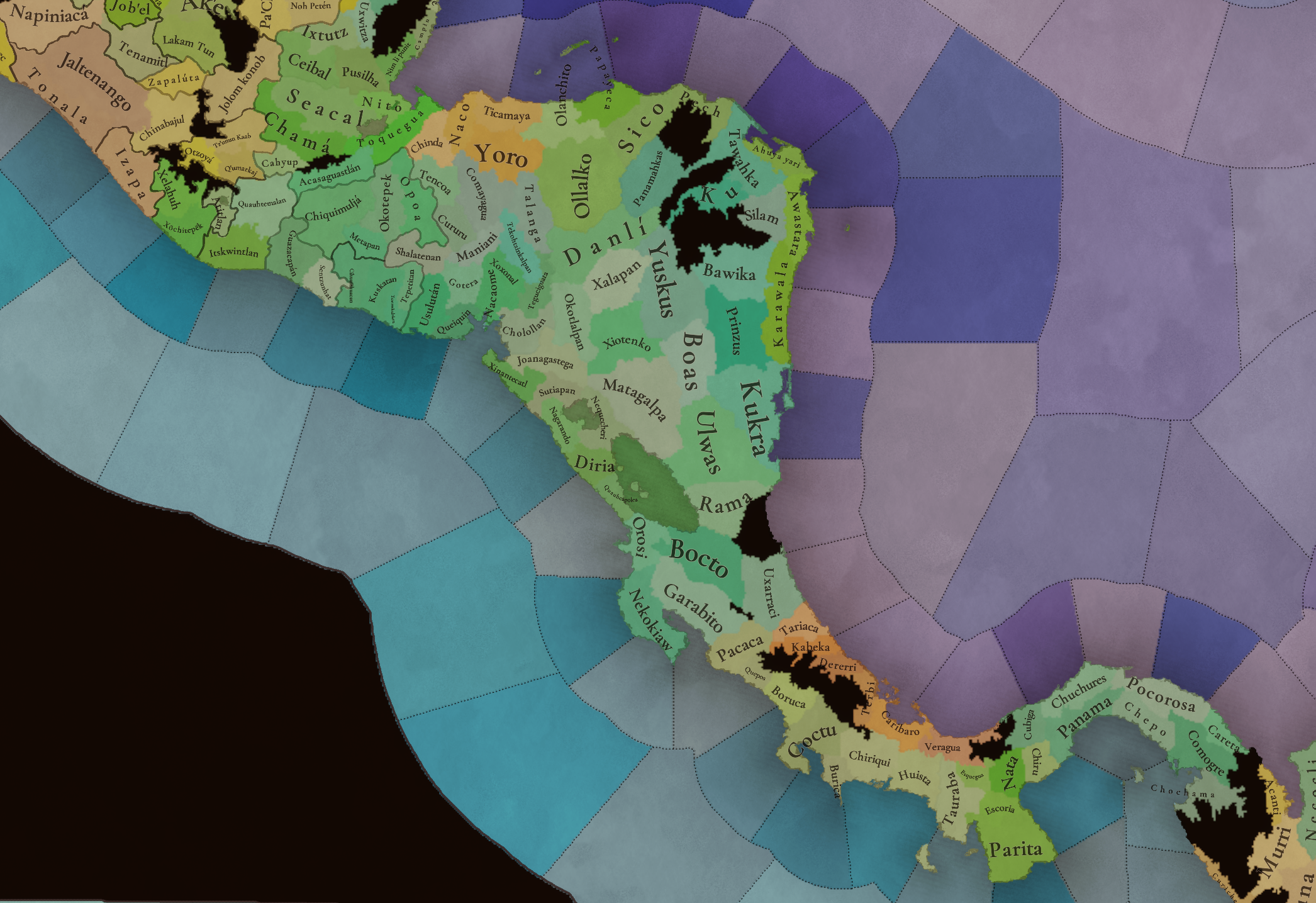
There isn't quite as much information out there as the Costa Rican kingdoms, but I'm thinking much of Panama should also be home to either SoPs or tribal kingdoms. Check out Urraca and the Spanish wiki page on the history of Panama, they mention chiefdoms.

Here's a map of the chiefdoms at the moment of contact, where green represents "kingdoms" (treated as the same level as most Mesoamerican states) and orange represents tribes with less clear political organization.

View attachment 1234856
Following up on this, the "Kingdom" of Parita now has its own wikipedia article, mentioning some of the neighboring chiefdoms, from which I found some very interesting sources: Ancient Panama: Chiefs in Search of Power and The Ancestors of Parita. Looking through those, it seems that the map is quite accurate in terms of territorial division, though I found no mention of Huista, Caribaro nor the island domains by name.

Ancient Panama details a heap of further complexity beneath this picture, listing 11 vassals for Nata alone, and 4 recently submitted and rebellious vassals for Parita, which you can find on the map as settlements if you look closely. It also details too many Cueva chiefdoms to count, which are also on the map in the orange region. Chagres is speculated as the chief town controlling the minor fishing village of Panama itself. Comogre is described as "the wealthiest, most powerful, and perhaps the largest chiefdom in eastern Panama". Pocorosa, Chepo, Chochama and Careta are also explicitly mentioned as chiefdoms, as is Cubiga. I thus see no reason to not fill Panama with OLM SoPs to match Costa Rica, though I'd rename Panama to Chagres and Chuchures to Sacativa.

Upon reflection though, I do not see a justifiable argument for making them settled states, as there is no evidence that they had any of the traditional attributes. There was also seemingly no urbanization in the entirety of the Isthmo-Colombian region. The Mississippians, as well as the Pacific Nicaraguans, have better cases though I will not make them here.

A couple other interesting tidbits:
1743544728714.png

"Maya" is obviously a vague label here and probably does not mean the Yucatec Maya. My guess is that they would be a Ch'olan-speaking group, as they are known as the migrating traders of the Maya world. Putum or perhaps Toquegua would be a good choice for the specific culture. I have a hunch this is related to the foreigners arriving by boat from the north, mentioned by Fowler in The Cultural Evolution of Ancient Nahua Civilizations. Because their affiliation is debated, I would suggest adding a mix of all three candidates - Pipil, Miskito, and Putum Maya merchants - as minorities to the location of Chuchures in Panama. The timeframe of their entrance is not mentioned, so they could start absent and arrive through an event, but if there aren't going to be any settled states here it's probably not worth it.

1743545516742.png

1743545778368.png

source: Narrative of Pascual de Andagoya

The wiki article on Parita says that these invaders were Mesoamericans, specifically Nicarao or Chorotega, which seems unconfirmed given the vague wording, but would make sense considering the detail of cannibalism which is a common occurence in Pipil-Nicarao and Chorotega oral tradition. It also says that the lord of Parita intervened on behalf of Tauraba.
 
  • 2Like
  • 1
  • 1
Reactions:
Is there anything suggestive of an Oto-Manguean affiliation besides the mention of "Otomi"?
Today I checked some more books at the CUCSH library but these only note the use of “Otomi” as something not Nahuatl (mexicano), similarly to the use of “Pinome” that like “Chontal” were used in multiples areas of Mesoamerica by Nahua peoples to refer to “foreign” people (even when is likely that Nahua peoples were the newcomers).

Even the use of “mexicano corrupto” in the context of the conquest could include a regional form of Nahuatl (non Central Mexico classical Nahuatl), a rough non-native use of Nahuatl as lingua franca, or even the recognition of related elements of some Utoaztecan languages.
  • Cifuentes, B. 1998. Letras sobre voces. Multilingüismo a través de la historia. Historia de los pueblos indígenas de México. Centro de Investigaciones y Estudios Superiores en Antropología Social.
  • García-Quintana, J., and Castillo-Ferreras, V. M. 1993. Lenguas y grupos indígenas de México al tiempo de la visita de Ponce. Universidad Nacional Autónoma de México.
  • Reyes-Garza, J. C. 2000. Al pie del volcán. Los indios de Colima en el virreinato. Historia de los pueblos indígenas de México. Centro de Investigaciones y Estudios Superiores en Antropología Social.
  • Yañez-Rosales, R. H. 2001. Rostro, palabra y memoria indígenas. El occidente de México 1524-1816. Historia de los pueblos indígenas de México. Centro de Investigaciones y Estudios Superiores en Antropología Social.
Language map proposal (representing the dominant language by location):
View attachment 1275373

It works on my proposed culture map as a base, so here's that for reference:
View attachment 1275372

This suggestion is explicitly unrealistic - ie, many of these languages contain varieties that are nowhere close to mutually intelligible. I chose a compromise between realism and game balance, recognizing the issue of scale and because tinto appears to be set upon a reductive approach. At the end of the day, it's a game, not an encyclopedia. For context, many of the individual cultures themselves are complex families of unintelligible varieties, yet I never considered subdividing them because they were historically viewed as unified languages, ignoring their internal diversity. So when I talk about making compromises that sacrifice realism, they are not the "normal" level, but rather even broader groupings which combine diverse peoples/languages that were never seen as the same or even particularly related.

Here are the languages I'm proposing, organized into families. Next to each language are listed the cultures it covers.

Uto-Aztecan family - I have reservations about including this family at all, as the branches seem to bear little resemblance to one another for the most part, excepting Nahuatl and Corachol.
  • Nahuatl: Nahua, Teco, Pipil, Nicarao, Caxcan, Tecuexe. Tlaxcaltec, Toltec if left in, Olmec, Cuyutec, Coixca, Coca if added.
  • Corachol: Huichol, Cora, Zacatecah, Cuachichitl, Sauzas if left in.
  • out of frame languages: Cahita, Hopi, Piman, Numic, Takic, Tarahumara

Oto-Manguean family - I also have reservations about including this family. There are clear typological similarities, but the languages are not close and I don't see much particular common heritage that cannot be generalized to Mesoamerica at large. I don't believe the speakers themselves would have realized the relationship.
  • Otomi: Otomi/"Otomanguean", Xi'oi, Matlatzinca, Tlahuica, Guamar, Iztachichimecah if left in, Jalisco Otomi (as I mentioned before, I have serious doubts about the relationship with the Otomi of Jalisco, but it is conventionally linked after all, and otherwise we would have nowhere to put it)
  • Zapotec: Zapotec, Chatino if added.
  • Mixtec: Mixtec, Amuzgo if added
  • Tlapanec: Me'phaa, Subtiaba if added
  • Chorotega: Chorotega, Chiapanec if added
  • Popoloca: Popoloca, Chinantec (this is the one paraphyletic language I am listing, which I do not like to do, but grouping either of these with Otomi or Zapotec feels quite wrong, and I didn't want to leave both as small one-culture languages though that would of course be the most realistic option).

Mayan family
  • Maya: Maaya, Kan Ek', Itza, Mopan, Kowoj
  • K'iche': K'iche', Tz'utujil, Kaqchikel, Q'eqchi', Poqom if added
  • Ch'ol: Ch'ol, Yokot'aanob, Putum, Manche if added, Winik Atel (Tzeltal), Sotz'leb (Tzotzil), Toquegua, Ch'orti', Tojolabal, Q'anjobal
  • Huastec: Teenek, Chicomuceltec if added (this is a small branch, but the most divergent, having been isolated since the very beginning of Mesoamerican history)

A more realistic version would see more diversity in the highlands, separating out the Qʼanjobal-Tojolabal and Mam, and possibly even the Tzotzil-Tzeltal, Poqom and Qʼeqchiʼ. Otherwise though, the cores of these branches were pretty closely knit by Project Caesar standards in the 1300s.

Chibchan family
  • Isthmic: Huetar, Cabecar, Boruca, Naso, Ngabe
  • Votic: Rama, Maleku
  • Pech
  • out of frame languages: Muisca, Tayrona

Isolates (in-game)
  • Purepecha
  • Totonac - opted against putting it in a family with Mixe-Zoque, as the relationship is as of yet unproven, not to mention distant and would be unknown in the period.
  • Mixe-Zoque: Zoque, Mixe, Tapachultec - Realistically would be a small family, but I grouped them together for balance
  • Misumalpan: Miskito, Kukra, Ulwa, Mayangna, Matagalpa - Realistically would be a small family, but I grouped them together for balance
  • Lenca - has no proven/relevant external relationships, thus I separated it from Misumalpan
  • Xinka
  • Huave
  • Cuitlatec: Cuitlatec, Tuxtec, Chumbia, Tepuztec. Cuitlatec is documented, the others are completely undocumented. Cuitlatec is an isolate to the best of our knowledge, and evidently has no external relation of any real relevance. We can't know the affiliation of the others, but these areas did reportedly share many cultural characteristics according to archaeological research, so grouping them together is the best option IMO.
  • Tequistlatec
  • Choco: Cueva. Out of frame: Embera, Waunaan, Quimbaya. Realistically would be a small family, but I grouped them together for balance
  • Tolupan
I didn't break down the Caribbean on the map, but Guanahatabey should be counted as the Warao language, as should Macorix if added. Ciguayo on the other hand should be counted as the Tolupan language. These three were most likely not Arawakan, and these are the best guesses as to their closest relatives.
In general I agree with your suggestions. Only for the culture map the localities corresponding to current Hostotipaquillo should be Tepecan with Tecual(Cora/Huichol) minority, current Tequila area should be Caxcan with Tepecan minority, current Villa Purificación, Sayula and proper Colima should have Nahua elites, Tepalcatepec in Michoacan was also Nahua, then Coca populations in modern Tlajomulco, Ocotlán and Jamay.

By the way the PC’s Sauzas and Iztacchichimecah do not need to be their own culture, the main branches of Chichimecs (Zacatec, Guachichil, Guamar and Pame) are enough. The partitions are better material for SoPs.

That makes sense, but aside from difficulty unifying those reasons aren't "game balance" just "gameplay".
Related to this there are other “gameplay vs simulation” issues that can come from the way languages (and cultures) are classified. For example, uniting multiple unrelated small languages/cultures would make these to have a higher relevance and survival rate since they would represent a bigger part of any nation while in real history being small and unrelated resulted in the fading of most of those.

I believe the Otomi culture should be switched to the Tonalist religion, as their religious system was absolutely more Mesoamerican than Chichimec. The Otomi practiced ritual blood-letting and nagualism (shape-shifting), and their cosmovision was rooted in the characteristic Mesoamerican dualism. The relacion geografica de Queretaro recorded that the local Otomies (which were among those most removed from the core of Mesoamerica) believed in Quetzalcoatl. As far as other deities, they had a fire deity known as Otontecuhtli ("Otomi lord") that had warrior cult characteristics similar to Huitzilopochtli. They worshipped a "old mother" and "old father" who are proposed to be equivalent to Tonantzin and Huehueteotl respectively. Much like the Mexicas, they also believed the universe had several layers and the world had been created and destroyed multiple times before (a la five suns myth). They had a ritual calendar bearing similarities to the major non-Maya Mesoamerican peoples.

Source: https://www.encyclopedia.com/environment/encyclopedias-almanacs-transcripts-and-maps/otomi-religion

View attachment 1275040

Really, the Otomi proper are only marginally and imprecisely called Chichimeca, and their culture must be distinguished from the more core Chichimeca (Zacateca, Guachichil, Guamar, Pame, Jonaz) in all aspects:
View attachment 1275039
source: Discovering the Chichimeca, Charlotte M. Gradie, The Americas

Side note, if the Otomi are Tonalist the closely related Matlatzinca should be as well, instead of Nahua. Merging Tonalist and Nahua would be a good idea, but consistency is important.

I will add this to my master post, along with the language map.
Agree. This is also the case for the Tecuexe and Caxcan people.
By the way, in these regions and even deeper into the Chichimec and Huastec areas are many monumental sites abandoned with the contraction of Mesoamerica in the Classic to Postclassic transition, some of these ruins still were places of rite in the 16th century.
 
Last edited:
  • 2Like
Reactions:
In general I agree with your suggestions. Only for the culture map the localities corresponding to current Hostotipaquillo should be Tepecan with Tecual(Cora/Huichol) minority, current Tequila area should be Caxcan with Tepecan minority, current Villa Purificación, Sayula and proper Colima should have Nahua elites, Tepalcatepec in Michoacan was also Nahua, then Coca populations in modern Tlajomulco, Ocotlán and Jamay.
You've done a lot more digging than me on Western Mexico, so I went ahead and implemented it. Actually, rereading the Handbook confirmed Nahua as a second language in Villa Purificacion as well as Tenamaxtlan, and I chose to use Teco as the local Nahua culture. Please let me know if anything looks wrong, and forgive my map-making skills which are not as beautiful as yours. Perhaps the Coca-majority locations need a Nahua minority? Purepecha is reported from Tuxpan, but I figured this was a later introduction with their conquests.

I also added the Chuchures in Panama and a Caxcan minority in Ameca. Will add a Chiapanec minority in Soconusco, but I need to change their color as it's too similar to Pipil. I also found a new source mentioning some interesting merchant communities around the region, but they are too small to note on the map.
cultures feedback labelled 9.0.png


By the way the PC’s Sauzas and Iztacchichimecah do not need to be their own culture, the main branches of Chichimecs (Zacatec, Guachichil, Guamar and Pame) are enough. The partitions are better material for SoPs.
Agree. Just haven't implemented it on the map, but I should. Can you confirm the Iztachichimecah presence in the Huasteca by chance?
 
Last edited:
  • 6Like
Reactions:
You've done a lot more digging than me on Western Mexico, so I went ahead and implemented it. Actually, rereading the Handbook confirmed Nahua as a second language in Villa Purificacion as well as Tenamaxtlan, and I chose to use Teco as the local Nahua culture. Please let me know if anything looks wrong, and forgive my map-making skills which are not as beautiful as yours. Perhaps the Coca-majority locations need a Nahua minority? Purepecha is reported from Tuxpan, but I figured this was a later introduction with their conquests.

I also added the Chuchures in Panama and a Caxcan minority in Ameca. Will add a Chiapanec minority in Soconusco, but I need to change their color as it's too similar to Pipil. I also found a new source mentioning some interesting merchant communities around the region, but they are too small to note on the map.
About Western Mexico the only details are the Tecuexe population at Tonalá(Tonallan) domains in Atemaxac and Tonallan (proper) locations. This is particularly relevant since the Tecuexe lords were the ones that resisted against Nuño de Guzmán contrary to queen Cihualpilli commands. Also a Totorame minority in Sentispac.

Agree. Just haven't implemented it on the map, but I should. Can you confirm the Iztachichimecah presence in the Huasteca by chance?
The Chichimec incursions into the Huasteca were made by the Macolia Guachichils around the Panuco river. The only other Chichimec group around the Huasteca is the Pame, properly added by your suggestion.

Talking about the Huasteca, Téenek populations should be added to the adjacent location north of river Panuco. A more detailed feedback for the Huasteca is part of my long “to do..” list of suggestions but the location layout is on my general mesoamerican suggestion early on the thread. The next works provide useful information about the northern Téenek frontier:

* Stresser-Péan, G. 2020. San Antonio Nogalar. Centro de estudios mexicanos y centroamericanos. El Colegio de San Luis. Universidad Autónoma de Tamaulipas.

* Urrutia-Jácome, J. L. 2021. Conquista y pacificación de la frontera de guerra de la Huasteca, siglos XVI-XVIII. El Colegio de San Luis.
 
  • 1Like
Reactions:
Western Hispaniola was looking pretty empty of harbours currently, so I took a bit of time to look into some possible locations.

hispaniola.png


The Samana location on Hispaniola should have a very high natural harbour suitability. It was considered such a good harbour that the United States government had made several attempts at purchasing it for a naval base in the 1800s.

Harvest of Empire: A History of Latinos in America
The first emissary from Washington, John Hogan, arrived the following year. Hogan immediately fixed his sights on the military potential of spectacular Samaná Bay in the northeast. Samaná, he reported back home, is "capable of providing protection to all the navies of the world."

Ulysses S. Grant: Soldier & President
Meanwhile, Seward was also trying to negotiate with the government of San Domingo for a long-term lease on Samaná Bay, one of the best anchorages in the Caribbean.

For some other possible natural harbours, this passage from the Bulletin of the International Bureau of the American Republics in 1909 lists a few other locations like Neiba Bay, Ocoa Bay, and Manzanillo Bay alongside Samana Bay.

The Dominican Republic has a number of splendid bays and inlets, forming excellent natural harbors and affording anchorage and shelter for the largest ocean-going vessels. The principal ports are: Puerto Plata, Sanchez, Santo Domingo, Macoris, Samana, Monte Cristi, and Barahona. The magnificent bay of Samana, also called Golfo de las Flechas, is 40 miles in length, with an average width of 15 miles, and is fully protected from the winds and storms and is one of the finest natural harbors of the world. The Bay of Neiba is 15 miles long, with an average width of 10 miles, and likewise affords safe anchorage for the largest ocean-going ships, as do also the bays of Ocoa and Manzanillo, and several others. Santo Domingo, the capital of the Republic, is situated at the mouth of the Ozama River, which is navigable for a considerable distance inland, as are also the rivers Yaque [del Norte], Yaque del Sur, Yuna, Iguamo, and several others, some of them, however, only for vessels of light draft.

Two of those seven principal ports of the time, Sanchez and Samana, are in Samana Bay, while a third port, Barahona, is in Neiba Bay. Monte Cristi is in Monte Cristi Bay while, Puerto Plata, is built around a small natural harbour. The last two—Santo Domingo and Macoris—are at the mouths of the rivers Ozama and Iguamo respectively.

So the Samana location should definitely be a high level natural harbour. The Azua location should have a natural harbour for Neiba and Ocoa Bay, while also being redrawn a bit to include more of Neiba Bay. Or maybe Baoruco should be split in two to have a location based around the Neiba Bay. The Magorix location should also have one for the Manzanillo and Monte Cristi Bays. The Bohio location could maybe have a low level natural harbour because of the small bays dotting the area like at Puerto Plata. Lastly, I'm not sure about if the Cayacoa locations and Hicayagua locations should have really low level natural harbours, because the settlements there have been using the river's mouth as a safe harbour.
 
  • 5Like
Reactions:
About Western Mexico the only details are the Tecuexe population at Tonalá(Tonallan) domains in Atemaxac and Tonallan (proper) locations. This is particularly relevant since the Tecuexe lords were the ones that resisted against Nuño de Guzmán contrary to queen Cihualpilli commands. Also a Totorame minority in Sentispac.


The Chichimec incursions into the Huasteca were made by the Macolia Guachichils around the Panuco river. The only other Chichimec group around the Huasteca is the Pame, properly added by your suggestion.

Talking about the Huasteca, Téenek populations should be added to the adjacent location north of river Panuco. A more detailed feedback for the Huasteca is part of my long “to do..” list of suggestions but the location layout is on my general mesoamerican suggestion early on the thread. The next works provide useful information about the northern Téenek frontier:

* Stresser-Péan, G. 2020. San Antonio Nogalar. Centro de estudios mexicanos y centroamericanos. El Colegio de San Luis. Universidad Autónoma de Tamaulipas.

* Urrutia-Jácome, J. L. 2021. Conquista y pacificación de la frontera de guerra de la Huasteca, siglos XVI-XVIII. El Colegio de San Luis.
The Iztachichimecah question led me to this paper: Vergara Hernández, Arturo (2008). El Infierno en la Pintura Mural Agustina Del Siglo XVI: Actopan y Xoxoteco en el Estado de Hidalgo, which says the following:
  • Actopan and Tulancingo were Otomi communities
  • Actopan and several other towns in Hidalgo had Chichimec (mainly Pame) minorities. In general, they were sedentized in the more arable zones, while in the drier zones they maintained a traditional nomadic existence. The former assimilated into Otomi culture much quicker. Thus in game terms, the Chichimec minorities can be mostly tribesmen in the Cold Arid locations and mostly peasants in the Tropical ones. The Chichimec presence is also backed up by the relaciones geográficas.
  • Otomi were not considered Chichimeca proper, but instead were more something in between the urban, fully "civilized" Nahua and the fully hunter-gatherer Chichimeca - that is, sedentary farmers who lacked large-scale urban centers and supplemented their agriculture with hunting. This is not unique in Mesoamerica of course
  • Otomi religion is indeed best considered Mesoamerican over Chichimec/Aridoamerican and was particularly similar to their Nahua neighbors, though the Mixcoatl cult is admittedly shared with the Chichimeca.
  • Pames apparently had some sedentary/Mesoamerican attributes, including temples, a priesthood, social stratification, territorial organization, and censuses, though the scale of all this was limited by the arid environment and a fully sedentary lifestyle being unfeasible. One scholar proposes them as a fusion culture between Otomi and Chichimec, which could explain their linguistic affiliation. I would want to find more sources to back up these points.
Per your advice, I added Huastec minorities to the north, and extended Totorame culture to the south. I made many other small adjustments from reviewing the relaciones geograficas and a couple papers, plus I noticed that Dzuluinicob was inhabited by Maya proper and not Mopan. On the topic of the Huasteca, I believe the lowlands should be much more politically divided, but I haven't found any details that would allow me to make a useful suggestion.

cultures feedback labelled 11.png
 
Last edited:
  • 2Like
  • 1
Reactions:
Western Hispaniola was looking pretty empty of harbours currently, so I took a bit of time to look into some possible locations.

View attachment 1276632

The Samana location on Hispaniola should have a very high natural harbour suitability. It was considered such a good harbour that the United States government had made several attempts at purchasing it for a naval base in the 1800s.

Harvest of Empire: A History of Latinos in America


Ulysses S. Grant: Soldier & President


For some other possible natural harbours, this passage from the Bulletin of the International Bureau of the American Republics in 1909 lists a few other locations like Neiba Bay, Ocoa Bay, and Manzanillo Bay alongside Samana Bay.


Two of those seven principal ports of the time, Sanchez and Samana, are in Samana Bay, while a third port, Barahona, is in Neiba Bay. Monte Cristi is in Monte Cristi Bay while, Puerto Plata, is built around a small natural harbour. The last two—Santo Domingo and Macoris—are at the mouths of the rivers Ozama and Iguamo respectively.

So the Samana location should definitely be a high level natural harbour. The Azua location should have a natural harbour for Neiba and Ocoa Bay, while also being redrawn a bit to include more of Neiba Bay. Or maybe Baoruco should be split in two to have a location based around the Neiba Bay. The Magorix location should also have one for the Manzanillo and Monte Cristi Bays. The Bohio location could maybe have a low level natural harbour because of the small bays dotting the area like at Puerto Plata. Lastly, I'm not sure about if the Cayacoa locations and Hicayagua locations should have really low level natural harbours, because the settlements there have been using the river's mouth as a safe harbour.
Yeah, Samaná bay being represented with no natural port value is extremely weird.
 
Reading The Legacy of Mesoamerica by Carmack/Gasco/Gossen was eye-opening on several topics, and I recommend consulting the second and third chapters.

It approaches the region through a core-periphery model, positing Central Mexico, Michoacan, Oaxaca, highland Guatemala and the Yucatan as the core regions with the most fully developed state systems. On the other hand, it posits Yopitzinco, the Huasteca, non-Maya Central America (especially the further southeast you travel), Jalisco/Nayarit/Sinaloa and Soconusco as periphery regions, describing the political landscape as more fractured and intermediate between chiefdoms and states, where political authority was not as centralized, there was little urbanization, and locals were not generally able to benefit much from the Mesoamerican exchange network. I think a good way of representing this reality would be to give these regions significant proportions of tribesmen pops, and in some cases perhaps even to give the local tags tribal governments. If we were to go more granular, I speculate there would be even more cases of these sort of societies - perhaps some of the non-Mixtec, non-Zapotec peoples of Oaxaca, some less prominent highland Mayan peoples, perhaps other parts of Guerrero, and probably most remote, rugged landscapes in general.

It describes the geography of the Mesoamerican trade network at contact, characterizing Soconusco, the region from Coatzacoalcos to Champoton, Cozumel, Nito/Naco (might be forgetting a couple) as sort of international trading hotspots, where merchants from competing core regions (for example, the Mexica and the Kiche) would come to exchange goods in a neutral setting. The small local states were thus incentivized to maintain neutrality in regional politics.

The book mentions some merchant communities we can add:
  • Oaxacan, Chiapan, Guatemalan merchants in Soconusco (probably mainly Mixtec, Tzotzil, Kiche cultures)
  • Kiche, Tzotzil, Yucatec, eastern Nahua merchants in Coatzacoalco, Xicalango, Chanputun. Nahuas were quite common around Xicalango and Acalan/Itzamkanac, and many members of the ruling class seem to have been Nahuas or Nahuatized
  • Acalan had a trading post at Nito
  • Mayan merchants in Escuintla, Guazacapan, El Salvador, interior Honduras, Pacific Nicaragua. My guess is these were mostly Kiche in Escuintla, Guazacapán and El Salvador and mostly Putún elsewhere
  • Kiche kingdom should be able to settle Pipiles in Suchitepequez to increase their commercial presence
  • Mixtec merchant barrios in the major towns in Central Mexico (assumedly Azcapotzalco, Cholula, Texcoco, Huejotzingo, Xochimilco, Chalco, Atlixco, etc). I suspect they may have also existed in highland and/or pacific Guatemala, but have not found an explicit source as of yet
  • Not from this source, but the codice de los tributos apparently mentioned that Tulancingo was a trading center between the Otomi, Tepehua and Totonac, so some Totonac merchants here would be a good idea while the town should be majority Otomi.
It makes a couple points about social structures: Central Mexican Nahua ("Aztecs") peasants were not very oppressed and benefitted from a robust commercial network. Aztecs developed an advanced administrative bureaucracy through delegation of power, Mixtecs did not. Mixtecs were perhaps the most stratified society in Mesoamerica, with almost no social mobility. Mixtecs did not have a specialized merchant class, but instead lesser nobility traded on behalf of the rulers. Mixtec artisans were members of the royal families.

A few river basins could be added to help spur trade and interaction:
  • Usumacinta (Tabasco, Chiapas)
  • Grijalva (Tabasco, Chiapas)
  • Candelaria (Campeche)
  • Motagua (Guatemala)
  • Hondo (Belize-Mexico border)
  • Ulua (western Honduras)
  • Balsas (Guerrero, Puebla)
  • Papaloapan and Coatzacoalcos (both in southern Veracruz) might also be a good idea to add, though they weren't mentioned in these chapters.
The chapters list many of the trade goods which different regions were known for. Most are covered by the current map, but I've underlined a few that could be added:
  • Yopitzinco: animal pelts, slaves
  • Lenca country (interior Honduras and eastern El Salvador): honey, cacao, slaves. Gold and other minerals in the northeast
  • Huasteca: rubber, bark cloth, turtle shells, animal skins, feathers, shells
  • Tabasco-Campeche: feathers, jade, skins, salt, slaves, cacao
  • Casas Grandes/Paquime: painted ceramics, copper ornaments, exotic feathers
  • Suchitepequez, Soconusco, Chetumal, Nito, Naco: cacao
  • Oaxaca: cacao, corn, fish, coral. Some of the most skilled metalworkers in Mesoamerica, particularly the Mixtecs.
  • Guerrero: gold, silver, cotton. Metalworkers (probably Cuitlatecs). The Taxco area became known in the colonial period for silver mining and the Sierra Madre del Sur also has important mineral deposits. I seem to remember cotton being produced in the Balsas basin, though apparently also by the Tlapanecs.
  • Puebla: corn
  • Veracruz: fish, coral
  • Michoacan: fish, wood, metalworkers
  • Papayeca: gold
  • Mayan highlands (Guatemala; Chiapas): jade, obsidian, grinding stones, metals, quetzal feathers
  • Mayan lowlands (Peten, Belize, Yucatan): textiles, pottery, slaves, honey, cacao
  • Northwest Mesoamerica at large: copper, gold, silver, turquoise, gems, cotton, seashells, aquatic birds, salt, peyote, desert flora/fauna
  • Jalisco, Colima, Nayarit: metals, cotton, salt, honey, cacao
Finally the book gives some population figures at contact:
  • Itzamkanac perhaps 10k
  • Q’umarkaaj perhaps 10-15k
  • Mayapan 11k
  • Tzintzuntzan 35k (at its height)
  • Tonalan (Jalisco) up to 10k
  • northeastern Belize "well populated"
  • approximately 200k Tenochtitlan (at its height, obviously)
  • Perhaps over 500k Lencas
 
Last edited:
  • 6
  • 2Love
Reactions: