• We have updated our Community Code of Conduct. Please read through the new rules for the forum that are an integral part of Paradox Interactive’s User Agreement.

Tinto Maps #29 - 13th of December 2024 - Central America

Hello everybody, and welcome to Tinto Maps, the happy Fridays for map lovers! Today, we will be looking at Central America, which includes the Caribbean. Before we start, I want to introduce you @RaulTrullenque , the only member of our Content Design team who had not yet gone public, and who worked really hard on the maps and content of the Central American and South American regions.

And now let’s get started without further ado!

Countries
Countries1.png

Countries2.png

Countries3.png

Countries4.png

Countries5.png

Countries6.png

Countries7.png

Tenochtitlan.png

Mayan.png
Welcome to the Mesoamerican Thunder Dome! This area is characterized by its numerous Altepetl, more or less comparable to city-states. Most of them are ruled in 1337 by peoples of Nahua origin, something that you may see much more clearly in the culture map. The biggest power in this moment is the Empire of P’urhépecherio, though, founded by the Purepecha people. In any case, you may notice that there’s a lot of detail in this area, including a tiny Nahua settlement recently founded on an island over Lake Texcoco, Tenochtitlan. This is the first time in a PDX GSG that we have the island itself present on the map, although the location covers some more land over the lake coast, to make it playable. Finally, we also have the Mayan polities of the Postclassic Period, of which Cocom, with its capital Màayapáan, was the most important, along with others, such as K’iche’ and its capital Q’umarkaj.

SoPs
SoPs1.png

SoPs2.png

SoPs3.png

SoPs4.png
On the outskirts of the Mesoamerican polities, there are plenty of peoples organized on different ways. To the north, we have the ones that populate the area known as Aridoamerica, which were collectively termed by the Nahua as ‘Chichimeca’. We also have plenty of societies close to the Mayan lands and the Isthmus. And, finally, the Taíno people populate some of the biggest islands in the Caribbean.

Locations
Locations1.png

Locations2.png

Locations3.png

Locations4.png

Locations5.png

Locations6.png

Locations7.png

Locations8.png

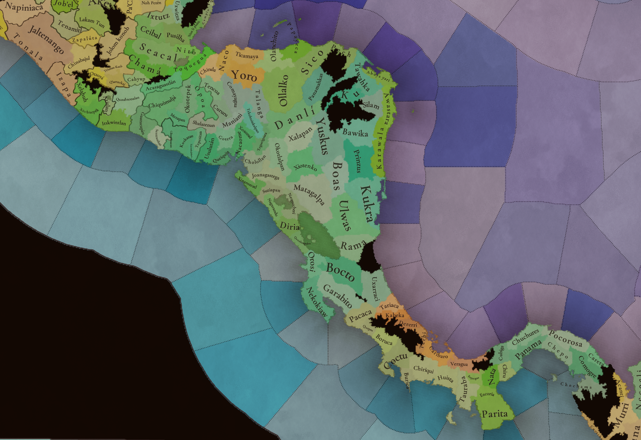
Plenty of locations here! I just want no note that the Darien Gap is an impassable wasteland, which means that any army trying to cross from modern Panama and Colombia will need transport ships to be able to do it.

Provinces
Provinces1.png

Provinces2.png


Areas
Areas1.png

Areas2.png


Terrain
Climate.png

Climate2.png

Topography.png

Vegetation.png

Vegetation2.png

A very diverse region! Most of it is covered by Tropical Jungles and Forests, but Sierra Madre Occidental and Oriental make for very specific conditions in the Mexican Altiplano, which are not only visible in the Topography map but also in the climate and vegetation of the area.

Development
Development2.png

The most developed regions in Mesoamerica are the Valley of Mexico and the Mayan coastline.

Natural Harbors
Harbors.png

There are some good ports in the Caribbean, no surprise that most of them would later become important cities in the Colonial Period.

Culture
Cultures.png

Cultures2.png

Tons of cultures!

Language
Dominant Languages1.png

Dominant Languages2.png

Court Language.png

And also languages! The first two maps are the Dominant Languages per location, while the third is the Court Languages one. The dark blue language is ‘Totozoquean’, as it is not so easily readable (something we have to change).

Religions
Religions.png

This map is today in a more advanced state, as we have merged plenty of cultural religions into regional groupings. Of these, Tonalism, Nahua, and Mayan are part of the Tonalist religious groups, while the others are part of the Folk American group (a regional split of the former ‘Animist’ group). Nahua and Mayan have their different mechanics, which we’ll talk about in future Tinto Talks. Let us know what do you think of this design and any suggestions about the religious grouping!

Raw Materials
Raw Materials1.png

Raw Materials2.png

Raw Materials3.png

Raw Materials4.png

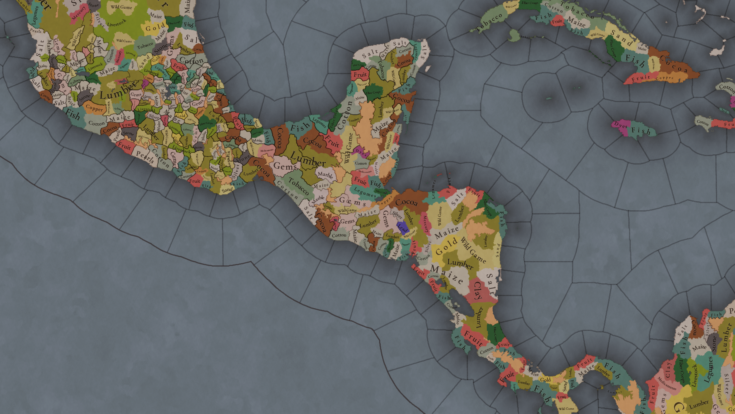
Maize is king in Mesoamerica, although there are plenty of other resources, including juicy Gold and Silver. Obsidian is not a separate resource, as it’s too regional-specific, so it’s included under the Gem coverage, but we have ways to represent it in-game; for instance, there’s a production method to produce Weaponry using Gems as an input.

Markets
Markets.png

A couple of bugs were reported while taking the screenshot of this map! But well, you can see that Azcapotzalco, Màayapáan, and Noh Petén (capital of the Itza people) are the most important ones.

Population
Population1.png

Population2.png

Population3.png

Population4.png

Population5.png

Population6.png

Population7.png

We have solved a couple of issues with the pop editor, and this week this map is in a decent state to be shown! Yay! Total numbers in the region are roughly 8.6M pops, distributed this way:
  • 523K in Aridoamerica (includes the lands to the North-West of the Purepecha Empire)
  • 6.947M in Mesoamerica (including North-Western Mayan lands)
  • 1.003M in Central America (including South-Eastern Mayan lands)
  • 151K in the Caribbean Islands

And that’s all for today! We hope you enjoyed these meaty maps! Next week we will be taking a look at the Levant Feedback, on Monday 16th, and South America, on Friday 20th! Cheers!
 
  • 117Like
  • 95Love
  • 5
  • 1
Reactions:
Something I forgot to mention until now, The Legacy of Mesoamerica's economic analysis supports adding a market in Tzintzuntzan and replacing the Kuskatan one with a market in the Kiche capital, which at that time was still Jakawitz, not yet Qumarkaj. The highlands of both Michoacan and Guatemala are identified as core regions in the late postclassic Mesoamerican trade network.

And Mesoamerican gameplay will benefit a lot from being able to establish trading posts outside of your territory, and even use them as a justification for territorial ambitions - this is how the Mexicas conquered Soconusco and the Huasteca. Tenochtitlan sent merchants out as far as the Costa Rica-Panama border.
 
Last edited:
  • 2Like
  • 2
Reactions:
My attempt at mapping out locations for Honduras (excluding the far northeast, which has less data):
1744329815706.png

blue = already in Project Caesar
Red = prehispanic settlement, not in PC
Yellow = colonial settlement, from what I can tell, not in PC

Slashes and parentheses indicate later Spanish names. I did leave out a handful of settlements that were especially close to each other, mainly around Camasca.

Now, increasing density in Honduras in my opinion is not of as critical importance as the core Maya regions of Guatemala, Yucatan, Tabasco, Chiapas - but it could use some nonetheless. As I previously suggested, I would definitely split up the Ollallko location into three or even four locations (Agalta, Escamilpa and Juticalpa) and add a Cerquin location in the southeast of Opoa (this is of historical importance to the conquest, being the base of Lempira). I might also add Sulaco or Guarabuqui to cut down Comayagua/Talanga a bit, and Cataguana out of the west of Yoro. Further density is possible as needed.

I would consider renaming the Chinda location to Quimistán, as that fits its shape much better.

Here are the maps I used for reference:
1744328895144.png

(the full map can be found here)
comayagua.png

The sources of the maps themselves are good, but the precise locations of some of the smallest settlements can sometimes be off, so it's important to double check on google maps or something.

By the way, notice that Gracias and Sensenti were regional capitals under the Spanish administration. Gracias especially was an important settlement for its mining. So assuming they aren't added as separate locations, they would make good Castillian dynamic names for Okotepek and Cerquin/Opoa.
 
  • 5Like
  • 2
Reactions:
Some excerpts from the Legacy of Mesomerica:
1000001644.png

1000001654.png


So I would argue for giving the Lencas, Chorotegas and Nicaraos settled states, albeit tribal kingdoms with low development.

For comparison, you can see here that it talks about Yopitzinco and the Huasteca (who are already considered settled states) in similar terms.
1000001646.png

1000001652.png
 
Last edited:
  • 3Like
  • 3
  • 1
Reactions:
Going deeper into Michoacán, there are various topics to discuss.

First the name of the Purépecha Empire. Between the different options the term Tarasco used by the Spaniards is now considered inappropriate, so “Tarascan Empire” is already discarded. Similarly the nahua people called them Michoaque and their core land Michihuacán hence the name of the modern Michoacán. Meanwhile the name P’urhépecherio refers to the land of the Purepecha people, but historically Purepecha were the common people not the state. There is also the option of Irécha Ts’intsúntsani referring to their capital at Tzintzuntzan, this is probably the safier name considering the nature of the mesoamerican city-states, plus it could be paired with the use of Tenochtitlan for the Mexica Empire. Finally there is the option of the Uacúsecha, this is the lineage of the Purépecha-Chichimeca that created and ruled the empire. So if PC has nations with dynastic names like the formable Timurid Empire, then there could be an Uacusecha Empire.

Now this last name takes us to the next issue. At PC’s starting date the Uacusechas were not in control of any main locality. Instead they were a distinctive group of “chichimecs” warriors that immigrated from the north making alliances with the “islanders/fishers” Purepechas around lake Patzcuaro.
By the year 1337 the Uacusecha brothers Vapeani (II) and Pauacume (II) were at the site of Vayameo near Mechuacan (Tzintzuntzan). In the first site the “chichimec” god Curicaueri and in the second site the local Xaratanga goddess were worshiped, but a bad omen drove the brothers Vapeani and Pauacume to leave Vayameo. Then first these brothers and then their descendants wandered for almost fifty years from one locality to another in a multigenerational drama of alliances, betrayals, poverty, glory, reunions, murder and mystical events.

(Approx 1350 to 1400)
MICHOACAN 01.png

To give a broad idea of this wandering in this map it is represented the route first of Pauacume from Vayameo to Tarimichundiro then his son Tariacuri (the real founder of the Purepecha Empire) until their return to Patzcuaro. There is also the Vapeani line but focused on his grandchildren Hiripan and Tangaxoan. And laterally the conquests made by Chapa the first of Tariacuri’s prospects to be the worthy king in name of the god Curicaueri.

It is very important to note the main rival states (at some points allies at other enemies) of our main Uacusecha line, these rivals were the city states of Xaraquaro, Tariaran and Curinguaro.

(Approx 1400 to 1440)
MICHOACAN 02.png


On the second map we can see the conquest made when Tariacuri was still alive, then the ones done directly by the triumvirate. This triumvirate were Tariacuri´s great-nephews Hiripan and Tangaxoan and his son Hiquingaje (the minor and only worthy of his own sons), whose Tariacuri made lords of Ihuatzio, Tzintzuntzan and Pátzcuaro respectively. Should note that even if Tariacuri was lord of Pátzcuaro the real conquest started when he send his triumvirate to the Tzintzuntzan area and this locality later was consolidated as the real core, kind of similar (but not the same) to how Tenochtitlan was the core of the Triple Alliance.

Should note that we can see a change of the titular city states for many localities, for example the rivals states of Xaraquaro, Tariaran and Curinguaro turned to be eclipsed by Erongaricuaro, Patzcuaro and Ihuatzio under the Uacusecha domain. This pattern repeated in others sites of the Purepecha Empire. Also note that many of PC's localities corresponding to the Mexica imperial provinces are kind of anachronic at the starting date since many times the “Aztec” provinces got their name from the site of the corresponding Mexica’s military garrison and center of tribute recollection, but this garrions were sometimes put in minor or new localities that were not the main city state before the Aztec conquest, one example of this is Cihuatlan in the coast of Guerrero.

(Around 1450)
MICHOACAN 03.png


For the third map we have a phase of rapid expansion in multiple fronts made by the “Caciques”, basically local and/or assigned chieftains that made their own regional campaigns in the name of the imperial authority. For some of these chieftains we have their specific names and conquests but for others zones there are general lists. Here I should note that the sites at the north were conquered (not colonized) therefore they should be proper tags.

(Late 15th century)
MICHOACAN 04.png


In the fourth map we have the conquest under the emperors Tzintzinpandacuare and Zuangua (II). Tzintzinpandacuare’s most relevant campaigns were the successful conquest of southern Jalisco (around Colima) to the west and the costly confrontation with the Mexica to the east, plus the temporary control of Zacatula. Then Zuangua expanded into Jalisco around Chapala and Sayula. Ticatame (II, son of Hiripan) conquest is also represented.
Again I must reaffirm that PC’s representation of the localities of Tala and Tlajomulco (in central Jalisco) as unoccupied is anachronistic and exaggerated. This miss representation should come from the early spanish chronicles that noted this sites to be depopulated by recent Purepecha raids, but this was over a century after PC’s starting date, so there is no reason to be this way at the beginning (even at the spanish arrival Tlajomulco was already again controlled by Tonala’s subjects).

(Early 16th century)
MICHOACAN 05.png

For the last map we have the domains of Tzintzuntzan, their main rivals the Mexica Empire to the east and south (the Aztec took over proper Zacatula while the extent of the Purepecha over the coast is unclear), and their other relevant rival the Kingdom of Colima (Colliman) who retook Sayula and Zapotlan as vassals in the “Saltpeter War” to the west. To the northwest Tonala (Tonallan) leads a coalition of minor city states included Cuitzeo and Coinan, these two allies repelled Purepecha incursions from Xacona, when spaniards arrived Coinan received them in peace but Cuitzeo resisted in battle. Pomaro is noted by the chronicles to never have been ruled by foreign powers.

NOTE: In each map states that were not directly refered were not colored to not distract from the topic.

References:
* Albiez-Wieck, S. 2013. Contactos exteriores del Estado Tarasco. Influencias desde dentro y fuera de Mesoamérica. Vol. I El Colegio de Michoacán.

* Alvarado, M. 1988. Del ascenso de los criollos y las pérdidas de una jurisdicción indígena en el noroeste de Michoacán. Tlazazalca en los siglos XVIII y XIX. Relaciones. vol 9. nº34.

* Dehouve, D. 1994. Entre el caimán y el jaguar: Los pueblos indios de Guerrero. Historia de los pueblos indígenas de México. Centro de Investigaciones y Estudios Superiores en Antropología Social.

* Espejel-Carbajal, C. 2004. Voces, lugares y tiempos. Claves para comprender la Relación de Michoacán. El Colegio de Michoacán, Centro de Estudios Históricos.

* Espejel-Carbajal, C. 2008. La justicia y el fuego. Dos claves para leer la Relación de Michoacán. El colegio de Michoacán.

* Fernandez-Poncela, A. M., and Rodas-Castan, S. J. 2023. Historia, identidad, paisaje, sentimientos y turismo en Tlalpujahua de Rayón. Revista de Investigación de la Ciencia Turística. nº17. pp. 26-45.

* Fibela-Lona, C. J. 2022. La negritud en La Piedad, Michoacán. Revista Chicomoztoc, vol.4 no. 7

* Novella, R. 1996. La Costa de Michoacán, Méjico, en el siglo XVI. Anales del Museo de América. nº4. pp. 25-37.

* Ochoa-Serrano, A. 1997. Mazamitla vista desde algunas fuentes. El Colegio de Michoacán. Estudios Jaliscienses. nº 30.

* Vargas-Uribe, G. 2018. Percepción del espacio y conquistas territoriales de los Purépechas prehispánicos, según la Relación de Michoacán de 1541. Historia y Patrimonio Cultural. Universidad de Salamanca. pp. 402-415.
 
Last edited:
  • 8
  • 4Like
  • 2Love
Reactions:
Now this last name takes us to the next issue. At PC’s starting date the Uacusechas were not in control of any main locality. Instead they were a distinctive group of “chichimecs” warriors that immigrated from the north making alliances with the “islanders/fishers” Purepechas around lake Patzcuaro.
This raises a few interesting questions for me:
1 - could the Uacusecha be represented as an army based country?
2 - should they be Purepecha culture yet, or instead some sort of Chichimec culture?

A couple sources do attest to widespread Nahua populations in highland Michoacan even after years of Purepecha rule (also some Chichimeca, which are identified as likely Pame or Jonaz), and it seems to me the most likely scenario is that most of the Chichimeca were Nahuatl speakers much like the Mexica, but eventually began to assimilate into the autochtonous Purepecha culture. There are other interpretations though, such as the Uacusecha being Purepecha-speaking backmigrants who had emigrated north in the classic, and Nahuatl-speaking Tolteca immigrating to Michoacan from Veracruz and bringing metalworking. Another question is whether these Chichimeca populations should be tribesmen instead of peasants.

If this is implemented, there could be some sort of event for them to transform into a settled country and switch to Purepecha culture as a power strategy.

A third question would be do you view the governance strategy of the Tzintzuntzan state as more centralized than the hegemonic strategy of the Mexica?

Your post is highly informative btw, great job.

  • Bellamy, Kate. On the external relations of Purepecha: An investigation into classification, contact and patterns of word formation. Diss. Leiden University, 2018.
  • Pollard, Helen Perlstein. “Central Places and Cities: A Consideration of the Protohistoric Tarascan State.” American Antiquity, vol. 45, no. 4, 1980, pp. 677–96. JSTOR, https://doi.org/10.2307/280141. Accessed 27 Apr. 2025.
 
Last edited:
  • 3
  • 2Like
Reactions:
This raises a few interesting questions for me:
1 - could the Uacusecha be represented as an army based country?
Yes. Considering their situation around PC's starting date I think they should be represented as an army based country now that PC have this kind of options.
The Uacusecha's wandering and the relation with their local rivals would be better protrayed if they could move from one place to other but without replace the locar lords that accomodate them. For example when they were at Vayame but did not control Tzintzuntzan, at Tarimichundiro/Patzuaro but being Tariaran the local power, or Hoataro Pexo under Curinguaro influence. This is also a scale issue since we would need a HRE locality size to properly portrait all the small city state localities. Then the use of the army based country mechanic would be the best solution for the representation of the Purepecha Empire's rise.

2 - should they be Purepecha culture yet, or instead some sort of Chichimec culture?
Both the Relación de Michoacán and recent archaeological research points to the Purepecha identiy of the Uacusecha despite the use of the "chichimec" label. Chichimec many times was a synonym of the "rudimentary" way of life on the mesoamerica frontier instead of an ethnic affiliation (like was the case for the "chichimec" Otomies). Seems like the Uacusecha ancestors were living around the Lerma river, a marginal zone after the contraction of Mesoamerica starting the Classical Period, but they still shared many cultural elements inclueded language with the local population first around Zacapu and then Patzcuaro lakes.
Concerning the nahua. Some historians interpreted the nahua populations on the Purepecha region as a link between the Uacusecha and the Nahuas, but this kind of scenario was proposed to every Nahua enclaves all around Mesoamerica. Then at late 19th to early 20th centuries these ideas developed into a sort of "Toltec-Aztec nationalist" discourse, thus the supposed "Tolte Empire" or how a lot of localities claims to be part of the Mexica pilgrimage. By the way the Zula locality is one of this doubtful aztec foundations.

About their pop's being tribesmen. By the starting date they still had identitarian elements associated with a tribesmen origin, but at the same time they already have some generations around the lakes Zacapu and Pátzcuaro so they were well adapted to the local ways. We can say they were in "transition", but for gameplay sake I think that they fit better as peasants, of course also had their own Noble, Clergy and Burgher pops.

For sure they would need their own chain of events that allow them to turn into a regular "land based" country by getting control of the Tzintzuntzan locality.
By the way this should be linked to the effigies of the god Curicaueri and the goddess Xaratanga. These could be represented as "holy/relic" Works of Art, being the first already in hands of the Uacusecha and the second one objetive to claim the authority over the local population.

A third question would be do you view the governance strategy of the Tzintzuntzan state as more centralized than the hegemonic strategy of the Mexica?
Definitely Tzintuntzan had a more centralized administrative way than the Mexica. But since seems like devs are planning some sort of unique government mechanic for Mesoamerica of even one for the Triple Alliance I can not suggest anything concise about it until we can see their details.
 
Last edited:
  • 2Like
  • 1
Reactions:
Completing the land based countries for Western Mexico, here are the nations from Nayarit, Jalisco and Colima.

nations JALISCO.png


The altepetl of Xalisco is the main power to the north west, dominating the coast from the Santiago river to Banderas bay, bordered by Aztatlan to the northwest and the SOPs from the Great Nayar to the Northeast (SOPs to be show soon). The name Xihutla is supposed to be for the region of Banderas valley, but in PC it only covers the area of Puerto Vallarta, a proper representation is to cover the valley centered at its main site of Tintoc (Tintoque) while for the area of Corrientes cape it's Tuitlán (Tuito).

Going inland,Cocollan (Cocula) did not have control over the Zacoalco-Atotonilco-Valencia lagoons area, neither Cutzalan was the main site there, and to the west the locality of Huitzquilic (San Martín Hidalgo) neither was a significative site for this scale. Therefore a major reorganization was made by adding Tecolotlán altepetl and locality taking the southwest of Cocollan, instead of Huitzquilic whose locality is distributed between Ameca taking the west side and Cocollan taking the east. Cutzalan locality change name to Tzacualco (Zacoalco) as domain of Sayula while the west of the later is used to add the Tlapálpan (Tapalpa) locality, a relevant site and a significant sierra dividing valleys at both sides.
To the southeast there is the already mentioned reorganization of the Zapotlan-Tamazula-Tuxpan valley that are too close to each others, so Zapotlan took over Tochpan (the Tuxpan at Veracruz should have priority) adding instead the Mazamitlán (Mazamitla) location to the east. Also Zapotlán should start as independent (vassal) from Coliman.

To the north Xochitepec can keep its name but the localities change name (Guaxacatlán and Tecuilan) and form (a little more to the northwest). Around Tonallan (Tonalá) zone, Tala would be controled by Etzatlán and Tlajomulco by Tonalá, the addition of Atemaxac (Atemajac) an altepetl more relevant than Tlajomulco that could even be represented as vassal instead of directly controlled by Tonalá, and covers the area of the proper Guadalajara and Zapopan. Ixtlahuacán change name to Tlacotlán and change ownership from Tonalá to Yahualica.

At Los Altos region, Mitic certainly is mentioned as one fo the Tecuexe altepetls, like is also Metzquititlan, but these were not of significance for PC scale, meanwhile the near locality of Teocaltiche under the Caxcans of Nochistlan was a more relevant site, so Mitic and Metzquititlan are replaced by Teocaltiche. Finally Coinan locality is (like PC’s Tepic locality) evidently too big, this one (like Tepic) can be easily divided into still relevant localities. Then Coinan dominates Coinan and Ayotlán plus the previously explained Cuitzeo at Chapala’s lake shore (not confuse it with the Cuitzeo at Michoacan).

CULTURES REWORK:
Considering the great and extensive suggestions by @nyetflix2 and more information that always emerges while looking at other topics, I should share an updated layout for the distribution of western Mexico’s cultures.

cultures western Mexico 02.png


In this map location’s main populations are background colors and dots are one or two minor populations (variable proportions). Corresponding colors are mostly the ones used in PC’s original. There are also a reference ID location map and tables of locations with cultures and nations below.

WESTERN MEXICO IDs 02.png

IDLOCATIONNATIONMAIN CULTUREMINOR AMINOR B
1BauzarigameIrritila
2ContótorIrritila
3BoboleIrritila
4CuauchichilGuachichil
5MiopacoaIrritila
6VasapalleIrritila
7CuencaméZacateca
8ConetoTepehuan
9AlamamaIrritila
10MapimíToboso
11IndehéTepehuan
12GuanacevíTepehuan
13TepehuanTepehuan
14PapasquiaroTepehuan
15CanatlánTepehuan
16BayacoraTepehuan
17NilapohuanaTepehuan
18CarapoaCahita
19AhomeCahitaSeri (Guaymas)
20SinaloaCahitaSeri (Guaymas)
21BadiraguatoAcaxee
22TopiaAcaxee
23TamaluzaAcaxee
24CulhuacánCuliacanTahueSeri (Guaymas)
25QuetzallanCuliacanTahue
26OtáezAcaxee
27GuarisameyXixime
28PiaxtlaCuliacanTahue
29MazatlánChiyametlanTotorame
30ChiametlánChiyametlanTotorame
31MaloyaXixime
32HetasíXixime

IDLOCATIONNATIONMAIN CULTUREMINOR AMINOR B
33AztatlánAztatlanXixime
34AcaponetaTepehuanHuichol
35TaxicoringaTepehuan
36NayarHuicholCora
37HuaynamotaHuicholCora
38XoraHuichol
39SentispacAztatlanCoraTotorame
40HuaristembaXaliscoCora
41XaliscoXaliscoCoraHuichol
42AhuacatlánAhuacatlanNahuaTecoCora
43CactlánXaliscoCora
44TintocXaliscoNahuaCora
45TiutlánTuitlanNahua
46TomatlánTomatlanPampuchin
47MelahuacanMelahuacanPampuchinNahua (Sayulteca)
48CuzalapaCuzalapaPampuchinNahua (Sayulteca)
49ZihuatlánTomatlanPampuchinNahua (Sayulteca)
50OstoticpacXaliscoTecoNahua (Cuyuteca)
51GuachinangoGuachinangoNahua (Cuyuteca)
52AmaxocotlánXaliscoNahua (Cuyuteca)
53CuautlaCuahutlaNahua (Cuyuteca)
54EtzatlánEtzatlanNahuaTecuexeCaxcan
55AmecaAmecaCoca
56CocollánCocollanCoca
57TecolotlánTecolotlanNahua (Cuyuteca)
58TenamaxtlánTenamaxtlanNahua (Cuyuteca)
59AutlánAutlanPinome
60AmollanAmollanPinomeNahua (Sayulteca)
61TlapálpanZapotlanPinomeNahua (Sayulteca)
62TzaulanSayulaNahua (Sayulteca)PinomeCoca
63TzacualcoSayulaCocaPinome
64ZapotlánZapotlanNahua (Sayulteca)Pinome
65XilotlánTamazollanXilotlantzincaNahua
66TamazollanTamazollanXilotlantzincaNahua (Sayulteca)
67MazamitlánXiquilpanPinomeCocaPurepecha
68ChapallanTonallanCocaNahua
69CuitzeoCuitzeoCoca
70AyotlánCoinanCocaTeco
71CoinanCoinanCocaTecuexe
72XalostotitlánXalostotitlanTecuexe
73MexticacánMexticacanTecuexe
74TepactitlánTepactitlanTecuexe
75YahualicanYahualicanTecuexe
76AcaticAcaticTecuexe
77TlacotlánYahualicanTecuexe
78AtemaxacTonallanTecuexe
79TonallanTonallanCocaTecuexeNahua
80TlaxomulcoTonallanCoca
81TlallanEtzatlanTecuexe
82TecuilanXochitepecCaxcanTecuexe
83GuaxacatlánXochitepecTepecanHuichol

IDLOCATIONNATIONMAIN CULTUREMINOR A
84TepecTepecan
85HuexuquillaTepecanHuichol
86MezquiticTepecan
87ColotlánTepecanCaxcan
88SusticacánCaxcanTepecan
89XalpanXochipillanCaxcan
90TlaltenangoTlaltenangoCaxcan
91TeulinchanTlaltenangoCaxcan
92XochipillaXochipillanCaxcan
93NochistlánNochistlanCaxcan
94TeocalticheNochistlanCaxcanTecuexe
95PechititlánGuachichil
96XiconaqueZacateca
97SauzaGuachichil
98TepezaláZacateca
99TlacuitlapánZacateca
100YamanquexZacateca
101ChalchícuitlZacateca
102PapantónZacateca
103ZainZacateca
104MazatlpilliGuachichil
105WirikutaGuachichil
106GuanchenisGuachichil
107MatehualaGuachichil
108MazatepecGuachichil
109MaticoyaGuamar
110TangamangaGuamar
111GuaxabanGuamar
112CopúzGuamar
113CocomacánGuamar
114QuijayGuamar
115XichúOtomiPame
116ApatzeoGuamarPame
117IrapuatoGuamar
118QuanaxhuatoGuamar
119CoecilloGuamar
120EpénxamuGuamar

IDLOCATIONNATIONMAIN CULTUREMINOR AMINOR B
121AngamacutiroAnagamacutiroPurepecha
122TlazazalcaTlazazalcaTecoPurepechaNahua
123ZulaZulaTecoNahua
124XaconaXaconaTecoPurepecha
125XiquilpanXiquilpanNahuaTeco
126ChocandiranChocandiranPurepechaTecoNahua
127ParachoCheranPurepecha
128TancítaroTancitaroTecoPurepecha
129UruapanUruapanPurepechaNahua
130ErongaricuaroXaraquaroPurepecha
131ZacapuCumanchenPurepecha
132TzintzuntzanTzintzuntzanPurepecha
133IhuatzioCuringuaroPurepechaNahua
134PátzcuaroTariaranPurepechaNahua
135TacámbaroTacambaroPurepecha
136GuayangareoCharoMatlatzincaOtomiPurepecha
137HuandacareoHetoquaroPurepechaOtomi
138YuririapundaroYuririapundaroGuamarPurepecha
139AcambaroAcambaroOtomiPame
140ZinapécuaroAraroOtomiNahua
141MaravatioMaravatioOtomi
142TlalpujahuaTlalpujahuaOtomi
143TaximaroaTaximaroaOtomi
144TzitácuaroTzitacuaroOtomiMatlatzinca
145CusaroTozantlaMatlatzinca
146CutzeoCutzeoMatlatzincaPurepecha
147CarácuaroHeperendanPurepechaMatlatzinca
148TuricatoPuruaranPurepecha
149ChurumucoChurumucoPurepecha
150AguacanaAguacanaPurepechaNahua
151ApatzingánApatzinganPurepechaNahua
152TepalcatepecTepalcatepecNahuaTeco
153ArimaoArimaoPurepechaNahua
154ChucutitlánZacatulaNahuaChumbia
155PómaroPomaroXilotlantzinca
156CoalcománCoalcomanXilotlantzinca
157AlimanColimaXilotlantzincaNahua
158TecománColimaNahua
159CollimanColimaNahua
160TepetitiangoColimaNahua

IDLOCATIONNATIONMAIN CULTUREMINOR AMINOR B
161ZacatulaZacatulaChumbia
162ZirandaroZirandaroChumbiaPurepecha
163PungarihuatoPungarihuatoCuitlatecaPurepecha
164IxtapaIxtapaChumbiaCuitlateca
165PetatlanPetatlanCuitlateca
166TecpanTecpanCuitlateca
167CoyucaCoyucaTlapanecaCuitlatecaNahua
168AcapolcoYopitzincoTlapaneca
169TixtlaYopitzincoTlapanecaNahua
170ChilapaTlapanTlapanecaNahua
171ZompancoZompancoTlapanecaNahua
172TetellanTetellanCuitlatecaTlapaneca
173AjuchitlánAjuchitlanCuitlatecaNahua
174CutzamalaCutzamalaMatlatzincaChontal

Some important points about this set of culture are the next ones:
  • Guasave culture, the Guasave people lived mostly at the coast of northern Sinaloa, in a “simpler” way than their inlander more populous Cahita and Tahue neighbors. So they should not be the main population for these localities, and maybe even they can be represented as Seri (Comcaac) since there it is speculated that they might be related based on their similar ways of life.
  • Cahita culture, here the Cahita could be used in two ways, as an umbrella name for the eastern minor cultures related to Yaqui and Mayo, but also as a culture that included the Yaqui and Mayo. These two could still be their own SoP nations to have both individual group identity but into an additional layer of similarity and game abstraction.
  • Cora and Huichol cultures, originally I put these together since they are closely related and there is uncertainty about identity in early sources with names like Tecuales, Quanes, Cuoanos, Visuritas, etc. But with nations like Xalisco and the resistance of the Great Nayar it is appropriate to keep them as their own as @nyetflix2 suggested.
  • Tecuexe and Coca cultures, these two (plus Caxcan) are well documented as different identities clearly differentiated between them and also in relation to Nahuas.
  • Pampuchin, Pinome and Xilotlantzinca cultures, coastal Jalisco, Colima and Michoacan had a lot of small and barely attested local languages that seems to be unrelated to Nahuatl (in fact local form of Nahuatl were taking over these regions), sometimes referred as “Otomi”, “Pinome” or “Piñoles”. Still it is possible to note 3 subregions for them. First, the central coast of Jalisco with languages like Pampuchin, Xocoteca, Tomateca, Chamelteca, etc. Second, the region around the valleys of Autlán, Amula, Sayula, Zapotlán and Zacoalco where generic names like Pinome and Otomi were used the most. And third, the coastal sierras from Tuxpan and Xilotlán to Cuauhcoma and Motines.
  • Guamar, Pame and Otomi cultures, in a simplified way here is a gradient from the more “Chichimec” Guamares to the more “Mesoamerican” Otomies. The Guamar around the Tunal Grande, the Pame at the sierras of San Luis Potosí, Querétaro and Hidalgo to the Otomi at the mesoamerican slopes and valleys to the southeast. Here Pame are the ones overlapping the most with both extremes. Not to forget that at the start the Chichimecs were pushing into Mesoamerica and with the Spanish conquest mesoamerican allies including Otomies were the ones used to colonize and push back their Chichimec relatives.
  • Teco and the many Nahua cultures, Nahua peoples were broadly distributed around most of Mesoamerican, these include some like the Cohuixca-Nahua and Tlahuica-Nahua (there are also the Tlahuica-Matlatzinca or Ocuilteca) at Guerrero. About Nayarit, Jalisco and Michoacán there were refered the presence of the Cuyuteca (likely Nahua), the Sayulteca (possible Nahua) and Teco (doubful Nahua) plus a lot of disperse sites were “Mexicano Corrupto” was locally spoken. Tecos/Tecoxines are the ones that seems to be their own culture but likely still related to Nahuas since the Purepecha used to see them as similar.
  • Chumbia culture, for practical in-game reasons, includes Tolimeca, Panteca and Apaneca.
  • Cuitlateca, Chontal and Tlapaneca cultures, these three cultures of Guerrero are mean to include informally others local minor cultures like Tepozteca, Tixteca and Tuzteca. The reason is that this region also has many Nahua populations and not major sites for all the poor attested cultures.
REFERENCES:
- Albiez-Wieck, S. 2013. Contactos exteriores del Estado Tarasco. Influencias desde dentro y fuera de Mesoamérica. Vol. I El Colegio de Michoacán.
- Brand, D. 1943. An Historical Sketch of Geography and Anthropology in the Tarascan Region: Part I. New Mexico Anthropologist, n°6. pp. 37-108.
- Dehouve, D. 1994. Entre el caimán y el jaguar: Los pueblos indios de Guerrero. Historia de los pueblos indígenas de México. Centro de Investigaciones y Estudios Superiores en Antropología Social.
- Dehouve, D. 2002. Cuando los banqueros eran santos. Historia económica y social de la provincia de Tlapa, Guerrero. Centro de Estudios Mexicanos y Centroamericanos. Universidad Autónoma de Guerrero.
- Delgadillo-Galindo, S. 2019. La resistencia ante la conquista de la Sierra Madre Occidental (1563-1618). Los casos Acaxee y Xixime. Universidad Juárez del Estado de Durango.
- Gallardo-Arias, P. 2022. Movilización de los Pames del Norte. Cuicuilco, Revista de Ciencias Antropológicas. nº 85.
- Gerhard, P. 1986. Geografía Histórica de la Nueva España, 1519-1821. Universidad Autónoma de México.
- Gerhard, P. 1996. La frontera norte de la Nueva España. Universidad Autónoma de México.
- Goyas-Mejía, R. 2017. Selvas yermas. Los pueblos de indios desaparecidos en la costa sur de la Nueva Galicia durante el periodo colonial. Revista de Historia Regional y Local. vol. 9. n°17. pp. 407-440.
- Gutiérrez-Mendoza, G. and Brito-Guadarrama, B. 2014. El Códice Azoyú 2. Política y territorio en el señorío de Tlapa-Tlachinollan, siglos XIV-XVI. Raíz del Sol. CONACULTA.
- León, N. 1903. Catálogo de la Colección de Antigüedades Tecas del territorio Michoacano. Museo Nacional.
- Medina-Miranda, H. 2019. Tras la pista de los Wixaritari: Los pueblos indígenas de la Sierra Madre Occidental en las crónicas tempranas (s. XVI-XVII). Revista Euroamericana de Antropología. n° 9. pp. 45-60.
- Melgarejo-Vivanco, J. L. 2015. Códices de Tierras. Los lienzos de Tuxpan. Universidad Veracruzana.
- Navarro-López, A. A. 2020. Construcción de un espacio. La frontera septentrional del obispado de Michoacán, 1536-1650. Universidad Nacional Autónoma de México.
- Tello, A. 1653. Libro segundo de la crónica miscelánea en que se trata de la conquista espiritual y temporal de la Santa Provincia de Jalisco en el Nuevo Reino de la Galicia y Nueva Vizcaya y descubrimiento del Nuevo México.
- Yañez-Rosales, R. H. 2001. Rostro, palabra y memoria indígenas. El occidente de México 1524-1816. Historia de los pueblos indígenas de México. Centro de Investigaciones y Estudios Superiores en Antropología Social.
 
  • 7Like
  • 4Love
Reactions:
Completing the land based countries for Western Mexico, here are the nations from Nayarit, Jalisco and Colima.

View attachment 1288780

The altepetl of Xalisco is the main power to the north west, dominating the coast from the Santiago river to Banderas bay, bordered by Aztatlan to the northwest and the SOPs from the Great Nayar to the Northeast (SOPs to be show soon). The name Xihutla is supposed to be for the region of Banderas valley, but in PC it only covers the area of Puerto Vallarta, a proper representation is to cover the valley centered at its main site of Tintoc (Tintoque) while for the area of Corrientes cape it's Tuitlán (Tuito).

Going inland,Cocollan (Cocula) did not have control over the Zacoalco-Atotonilco-Valencia lagoons area, neither Cutzalan was the main site there, and to the west the locality of Huitzquilic (San Martín Hidalgo) neither was a significative site for this scale. Therefore a major reorganization was made by adding Tecolotlán altepetl and locality taking the southwest of Cocollan, instead of Huitzquilic whose locality is distributed between Ameca taking the west side and Cocollan taking the east. Cutzalan locality change name to Tzacualco (Zacoalco) as domain of Sayula while the west of the later is used to add the Tlapálpan (Tapalpa) locality, a relevant site and a significant sierra dividing valleys at both sides.
To the southeast there is the already mentioned reorganization of the Zapotlan-Tamazula-Tuxpan valley that are too close to each others, so Zapotlan took over Tochpan (the Tuxpan at Veracruz should have priority) adding instead the Mazamitlán (Mazamitla) location to the east. Also Zapotlán should start as independent (vassal) from Coliman.

To the north Xochitepec can keep its name but the localities change name (Guaxacatlán and Tecuilan) and form (a little more to the northwest). Around Tonallan (Tonalá) zone, Tala would be controled by Etzatlán and Tlajomulco by Tonalá, the addition of Atemaxac (Atemajac) an altepetl more relevant than Tlajomulco that could even be represented as vassal instead of directly controlled by Tonalá, and covers the area of the proper Guadalajara and Zapopan. Ixtlahuacán change name to Tlacotlán and change ownership from Tonalá to Yahualica.

At Los Altos region, Mitic certainly is mentioned as one fo the Tecuexe altepetls, like is also Metzquititlan, but these were not of significance for PC scale, meanwhile the near locality of Teocaltiche under the Caxcans of Nochistlan was a more relevant site, so Mitic and Metzquititlan are replaced by Teocaltiche. Finally Coinan locality is (like PC’s Tepic locality) evidently too big, this one (like Tepic) can be easily divided into still relevant localities. Then Coinan dominates Coinan and Ayotlán plus the previously explained Cuitzeo at Chapala’s lake shore (not confuse it with the Cuitzeo at Michoacan).

CULTURES REWORK:
Considering the great and extensive suggestions by @nyetflix2 and more information that always emerges while looking at other topics, I should share an updated layout for the distribution of western Mexico’s cultures.

View attachment 1288781

In this map location’s main populations are background colors and dots are one or two minor populations (variable proportions). Corresponding colors are mostly the ones used in PC’s original. There are also a reference ID location map and tables of locations with cultures and nations below.


IDLOCATIONNATIONMAIN CULTUREMINOR AMINOR B
1BauzarigameIrritila
2ContótorIrritila
3BoboleIrritila
4CuauchichilGuachichil
5MiopacoaIrritila
6VasapalleIrritila
7CuencaméZacateca
8ConetoTepehuan
9AlamamaIrritila
10MapimíToboso
11IndehéTepehuan
12GuanacevíTepehuan
13TepehuanTepehuan
14PapasquiaroTepehuan
15CanatlánTepehuan
16BayacoraTepehuan
17NilapohuanaTepehuan
18CarapoaCahita
19AhomeCahitaSeri (Guaymas)
20SinaloaCahitaSeri (Guaymas)
21BadiraguatoAcaxee
22TopiaAcaxee
23TamaluzaAcaxee
24CulhuacánCuliacanTahueSeri (Guaymas)
25QuetzallanCuliacanTahue
26OtáezAcaxee
27GuarisameyXixime
28PiaxtlaCuliacanTahue
29MazatlánChiyametlanTotorame
30ChiametlánChiyametlanTotorame
31MaloyaXixime
32HetasíXixime

IDLOCATIONNATIONMAIN CULTUREMINOR AMINOR B
33AztatlánAztatlanXixime
34AcaponetaTepehuanHuichol
35TaxicoringaTepehuan
36NayarHuicholCora
37HuaynamotaHuicholCora
38XoraHuichol
39SentispacAztatlanCoraTotorame
40HuaristembaXaliscoCora
41XaliscoXaliscoCoraHuichol
42AhuacatlánAhuacatlanNahuaTecoCora
43CactlánXaliscoCora
44TintocXaliscoNahuaCora
45TiutlánTuitlanNahua
46TomatlánTomatlanPampuchin
47MelahuacanMelahuacanPampuchinNahua (Sayulteca)
48CuzalapaCuzalapaPampuchinNahua (Sayulteca)
49ZihuatlánTomatlanPampuchinNahua (Sayulteca)
50OstoticpacXaliscoTecoNahua (Cuyuteca)
51GuachinangoGuachinangoNahua (Cuyuteca)
52AmaxocotlánXaliscoNahua (Cuyuteca)
53CuautlaCuahutlaNahua (Cuyuteca)
54EtzatlánEtzatlanNahuaTecuexeCaxcan
55AmecaAmecaCoca
56CocollánCocollanCoca
57TecolotlánTecolotlanNahua (Cuyuteca)
58TenamaxtlánTenamaxtlanNahua (Cuyuteca)
59AutlánAutlanPinome
60AmollanAmollanPinomeNahua (Sayulteca)
61TlapálpanZapotlanPinomeNahua (Sayulteca)
62TzaulanSayulaNahua (Sayulteca)PinomeCoca
63TzacualcoSayulaCocaPinome
64ZapotlánZapotlanNahua (Sayulteca)Pinome
65XilotlánTamazollanXilotlantzincaNahua
66TamazollanTamazollanXilotlantzincaNahua (Sayulteca)
67MazamitlánXiquilpanPinomeCocaPurepecha
68ChapallanTonallanCocaNahua
69CuitzeoCuitzeoCoca
70AyotlánCoinanCocaTeco
71CoinanCoinanCocaTecuexe
72XalostotitlánXalostotitlanTecuexe
73MexticacánMexticacanTecuexe
74TepactitlánTepactitlanTecuexe
75YahualicanYahualicanTecuexe
76AcaticAcaticTecuexe
77TlacotlánYahualicanTecuexe
78AtemaxacTonallanTecuexe
79TonallanTonallanCocaTecuexeNahua
80TlaxomulcoTonallanCoca
81TlallanEtzatlanTecuexe
82TecuilanXochitepecCaxcanTecuexe
83GuaxacatlánXochitepecTepecanHuichol

IDLOCATIONNATIONMAIN CULTUREMINOR A
84TepecTepecan
85HuexuquillaTepecanHuichol
86MezquiticTepecan
87ColotlánTepecanCaxcan
88SusticacánCaxcanTepecan
89XalpanXochipillanCaxcan
90TlaltenangoTlaltenangoCaxcan
91TeulinchanTlaltenangoCaxcan
92XochipillaXochipillanCaxcan
93NochistlánNochistlanCaxcan
94TeocalticheNochistlanCaxcanTecuexe
95PechititlánGuachichil
96XiconaqueZacateca
97SauzaGuachichil
98TepezaláZacateca
99TlacuitlapánZacateca
100YamanquexZacateca
101ChalchícuitlZacateca
102PapantónZacateca
103ZainZacateca
104MazatlpilliGuachichil
105WirikutaGuachichil
106GuanchenisGuachichil
107MatehualaGuachichil
108MazatepecGuachichil
109MaticoyaGuamar
110TangamangaGuamar
111GuaxabanGuamar
112CopúzGuamar
113CocomacánGuamar
114QuijayGuamar
115XichúOtomiPame
116ApatzeoGuamarPame
117IrapuatoGuamar
118QuanaxhuatoGuamar
119CoecilloGuamar
120EpénxamuGuamar

IDLOCATIONNATIONMAIN CULTUREMINOR AMINOR B
121AngamacutiroAnagamacutiroPurepecha
122TlazazalcaTlazazalcaTecoPurepechaNahua
123ZulaZulaTecoNahua
124XaconaXaconaTecoPurepecha
125XiquilpanXiquilpanNahuaTeco
126ChocandiranChocandiranPurepechaTecoNahua
127ParachoCheranPurepecha
128TancítaroTancitaroTecoPurepecha
129UruapanUruapanPurepechaNahua
130ErongaricuaroXaraquaroPurepecha
131ZacapuCumanchenPurepecha
132TzintzuntzanTzintzuntzanPurepecha
133IhuatzioCuringuaroPurepechaNahua
134PátzcuaroTariaranPurepechaNahua
135TacámbaroTacambaroPurepecha
136GuayangareoCharoMatlatzincaOtomiPurepecha
137HuandacareoHetoquaroPurepechaOtomi
138YuririapundaroYuririapundaroGuamarPurepecha
139AcambaroAcambaroOtomiPame
140ZinapécuaroAraroOtomiNahua
141MaravatioMaravatioOtomi
142TlalpujahuaTlalpujahuaOtomi
143TaximaroaTaximaroaOtomi
144TzitácuaroTzitacuaroOtomiMatlatzinca
145CusaroTozantlaMatlatzinca
146CutzeoCutzeoMatlatzincaPurepecha
147CarácuaroHeperendanPurepechaMatlatzinca
148TuricatoPuruaranPurepecha
149ChurumucoChurumucoPurepecha
150AguacanaAguacanaPurepechaNahua
151ApatzingánApatzinganPurepechaNahua
152TepalcatepecTepalcatepecNahuaTeco
153ArimaoArimaoPurepechaNahua
154ChucutitlánZacatulaNahuaChumbia
155PómaroPomaroXilotlantzinca
156CoalcománCoalcomanXilotlantzinca
157AlimanColimaXilotlantzincaNahua
158TecománColimaNahua
159CollimanColimaNahua
160TepetitiangoColimaNahua

IDLOCATIONNATIONMAIN CULTUREMINOR AMINOR B
161ZacatulaZacatulaChumbia
162ZirandaroZirandaroChumbiaPurepecha
163PungarihuatoPungarihuatoCuitlatecaPurepecha
164IxtapaIxtapaChumbiaCuitlateca
165PetatlanPetatlanCuitlateca
166TecpanTecpanCuitlateca
167CoyucaCoyucaTlapanecaCuitlatecaNahua
168AcapolcoYopitzincoTlapaneca
169TixtlaYopitzincoTlapanecaNahua
170ChilapaTlapanTlapanecaNahua
171ZompancoZompancoTlapanecaNahua
172TetellanTetellanCuitlatecaTlapaneca
173AjuchitlánAjuchitlanCuitlatecaNahua
174CutzamalaCutzamalaMatlatzincaChontal

Some important points about this set of culture are the next ones:
  • Guasave culture, the Guasave people lived mostly at the coast of northern Sinaloa, in a “simpler” way than their inlander more populous Cahita and Tahue neighbors. So they should not be the main population for these localities, and maybe even they can be represented as Seri (Comcaac) since there it is speculated that they might be related based on their similar ways of life.
  • Cahita culture, here the Cahita could be used in two ways, as an umbrella name for the eastern minor cultures related to Yaqui and Mayo, but also as a culture that included the Yaqui and Mayo. These two could still be their own SoP nations to have both individual group identity but into an additional layer of similarity and game abstraction.
  • Cora and Huichol cultures, originally I put these together since they are closely related and there is uncertainty about identity in early sources with names like Tecuales, Quanes, Cuoanos, Visuritas, etc. But with nations like Xalisco and the resistance of the Great Nayar it is appropriate to keep them as their own as @nyetflix2 suggested.
  • Tecuexe and Coca cultures, these two (plus Caxcan) are well documented as different identities clearly differentiated between them and also in relation to Nahuas.
  • Pampuchin, Pinome and Xilotlantzinca cultures, coastal Jalisco, Colima and Michoacan had a lot of small and barely attested local languages that seems to be unrelated to Nahuatl (in fact local form of Nahuatl were taking over these regions), sometimes referred as “Otomi”, “Pinome” or “Piñoles”. Still it is possible to note 3 subregions for them. First, the central coast of Jalisco with languages like Pampuchin, Xocoteca, Tomateca, Chamelteca, etc. Second, the region around the valleys of Autlán, Amula, Sayula, Zapotlán and Zacoalco where generic names like Pinome and Otomi were used the most. And third, the coastal sierras from Tuxpan and Xilotlán to Cuauhcoma and Motines.
  • Guamar, Pame and Otomi cultures, in a simplified way here is a gradient from the more “Chichimec” Guamares to the more “Mesoamerican” Otomies. The Guamar around the Tunal Grande, the Pame at the sierras of San Luis Potosí, Querétaro and Hidalgo to the Otomi at the mesoamerican slopes and valleys to the southeast. Here Pame are the ones overlapping the most with both extremes. Not to forget that at the start the Chichimecs were pushing into Mesoamerica and with the Spanish conquest mesoamerican allies including Otomies were the ones used to colonize and push back their Chichimec relatives.
  • Teco and the many Nahua cultures, Nahua peoples were broadly distributed around most of Mesoamerican, these include some like the Cohuixca-Nahua and Tlahuica-Nahua (there are also the Tlahuica-Matlatzinca or Ocuilteca) at Guerrero. About Nayarit, Jalisco and Michoacán there were refered the presence of the Cuyuteca (likely Nahua), the Sayulteca (possible Nahua) and Teco (doubful Nahua) plus a lot of disperse sites were “Mexicano Corrupto” was locally spoken. Tecos/Tecoxines are the ones that seems to be their own culture but likely still related to Nahuas since the Purepecha used to see them as similar.
  • Chumbia culture, for practical in-game reasons, includes Tolimeca, Panteca and Apaneca.
  • Cuitlateca, Chontal and Tlapaneca cultures, these three cultures of Guerrero are mean to include informally others local minor cultures like Tepozteca, Tixteca and Tuzteca. The reason is that this region also has many Nahua populations and not major sites for all the poor attested cultures.
REFERENCES:
- Albiez-Wieck, S. 2013. Contactos exteriores del Estado Tarasco. Influencias desde dentro y fuera de Mesoamérica. Vol. I El Colegio de Michoacán.
- Brand, D. 1943. An Historical Sketch of Geography and Anthropology in the Tarascan Region: Part I. New Mexico Anthropologist, n°6. pp. 37-108.
- Dehouve, D. 1994. Entre el caimán y el jaguar: Los pueblos indios de Guerrero. Historia de los pueblos indígenas de México. Centro de Investigaciones y Estudios Superiores en Antropología Social.
- Dehouve, D. 2002. Cuando los banqueros eran santos. Historia económica y social de la provincia de Tlapa, Guerrero. Centro de Estudios Mexicanos y Centroamericanos. Universidad Autónoma de Guerrero.
- Delgadillo-Galindo, S. 2019. La resistencia ante la conquista de la Sierra Madre Occidental (1563-1618). Los casos Acaxee y Xixime. Universidad Juárez del Estado de Durango.
- Gallardo-Arias, P. 2022. Movilización de los Pames del Norte. Cuicuilco, Revista de Ciencias Antropológicas. nº 85.
- Gerhard, P. 1986. Geografía Histórica de la Nueva España, 1519-1821. Universidad Autónoma de México.
- Gerhard, P. 1996. La frontera norte de la Nueva España. Universidad Autónoma de México.
- Goyas-Mejía, R. 2017. Selvas yermas. Los pueblos de indios desaparecidos en la costa sur de la Nueva Galicia durante el periodo colonial. Revista de Historia Regional y Local. vol. 9. n°17. pp. 407-440.
- Gutiérrez-Mendoza, G. and Brito-Guadarrama, B. 2014. El Códice Azoyú 2. Política y territorio en el señorío de Tlapa-Tlachinollan, siglos XIV-XVI. Raíz del Sol. CONACULTA.
- León, N. 1903. Catálogo de la Colección de Antigüedades Tecas del territorio Michoacano. Museo Nacional.
- Medina-Miranda, H. 2019. Tras la pista de los Wixaritari: Los pueblos indígenas de la Sierra Madre Occidental en las crónicas tempranas (s. XVI-XVII). Revista Euroamericana de Antropología. n° 9. pp. 45-60.
- Melgarejo-Vivanco, J. L. 2015. Códices de Tierras. Los lienzos de Tuxpan. Universidad Veracruzana.
- Navarro-López, A. A. 2020. Construcción de un espacio. La frontera septentrional del obispado de Michoacán, 1536-1650. Universidad Nacional Autónoma de México.
- Tello, A. 1653. Libro segundo de la crónica miscelánea en que se trata de la conquista espiritual y temporal de la Santa Provincia de Jalisco en el Nuevo Reino de la Galicia y Nueva Vizcaya y descubrimiento del Nuevo México.
- Yañez-Rosales, R. H. 2001. Rostro, palabra y memoria indígenas. El occidente de México 1524-1816. Historia de los pueblos indígenas de México. Centro de Investigaciones y Estudios Superiores en Antropología Social.
Nice work! Do you have suggestions for what languages Teco, Xilotlantzinca, Pinome, Pampuchin, Coca should be assigned in game? Perhaps Uto-Aztecan but not Nahuatl itself? The only one of these I have seen any real suggestions for is Coca being Uto-Aztecan based on a supposed wordlist (and Teco/Xilotlantzinca as Nahua, but you've already explained that issue). Cuitlatec is relatively well documented and we know that it is not closely related to anything and probably an isolate. I grouped Chumbia and Chontal with it based on proximity but now that I revisit it, I personally think Chontal may have been Oto-Manguean or Mixe-Zoque, because it was written that "it was spoken in the throat" and "it wasn't written because it wasn't pronounced".

Culture groups would also be an interesting topic to discuss in this region.

Cora and Huichol cultures, originally I put these together since they are closely related and there is uncertainty about identity in early sources with names like Tecuales, Quanes, Cuoanos, Visuritas, etc. But with nations like Xalisco and the resistance of the Great Nayar it is appropriate to keep them as their own as @nyetflix2 suggested.
Their history is obscure to me, you probably know best. I separated them on the basis of Coras being missing entirely in the original tinto maps, and wanting to have a solid case for their presence. Perhaps they could be combined, though linguistically speaking at least I believe they are not actually so close, they don't have any mutual intelligibility IIRC - compare that to a pair like Mayo and Yaqui which do have some.

A few minor comments on the culture map (mainly based on the relaciones geograficas):
  • I haven't heard of Chontal in Cutzamala. However they should be present as a minority in Tetellan alongside Nahuas, and apparently Zirondaro.
  • "Totonac" was reported in the jurisdiction of Ameca. I doubt this was Totonac proper, it could be one of the local languages and the name could refer to a hot climate.
  • "Otomi" and Xilotlantzinca were present in the province of Colima (thus probably also Tecoman and Tepetitiango), alongside Nahua
  • Tenamastlan had unidentified non-Nahua languages as well
  • Nahua was reported in Coalcoman alongside Cuauhcomec
  • Arimao seems a bit far south for Purepecha in 1337
  • Honestly I suspect a Cuitlatec presence in Cutzeo given the proximity and similar environment to other settlements of theirs, but I have no evidence.
 
Last edited:
  • 5Like
Reactions:
This paper discussing the geography of the Ch'olan languages has some interesting details supporting many of the locations I proposed for Tabasco and Peten. Also note the widespread distribution of the Manche Ch'ol, whose territory is currently considered Qeqchi in Project Caesar.

1746334620586.png

1746334630993.png

1746334641759.png

Soon I will update my location map, replacing the anachronistic Ak'e (Bonampak) with Pochtula and Topiltepeque in Chiapas, and adding Mazcab and/or Chivoha in Campeche. Possibly also Xocolo (modern San Felipe de Lara) on the shore of Lake Izabal.
 
  • 3
  • 1Like
Reactions:
Nice work! Do you have suggestions for what languages Teco, Xilotlantzinca, Pinome, Pampuchin, Coca should be assigned in game? Perhaps Uto-Aztecan but not Nahuatl itself? The only one of these I have seen any real suggestions for is Coca being Uto-Aztecan based on a supposed wordlist (and Teco/Xilotlantzinca as Nahua, but you've already explained that issue). Cuitlatec is relatively well documented and we know that it is not closely related to anything and probably an isolate. I grouped Chumbia and Chontal with it based on proximity but now that I revisit it, I personally think Chontal may have been Oto-Manguean or Mixe-Zoque, because it was written that "it was spoken in the throat" and "it wasn't written because it wasn't pronounced".
Thanks. About languages:
The Teco was almost for sure an Uto-Aztecan language, Coca seems probably. For Xilotlanzinca are two hypothesis, the firts being related to Nahua but this could be because their use of "mexicano corrupto" as lingua franca and the second one that Xilotlanzinca was a synonym with Piñol therefore "Otomi-like". Pinome including "Otomi" likely was Oto-Manguean, while "Pampuchin" (as a regional umbrella) is the one with less sources to figure their relation. For Chontal it seems to be a good possibility to be Otopamean.
Culture groups would also be an interesting topic to discuss in this region.
For a concise culture grouping suggestion I would like to wait to analyze the rest of PC's Mesoamerica, still some points that I have in mind are:
- Since languages are their own category in PC (unlike EU4) we could depend less on language for culture grouping. For example the Chichimeca culture group including both "Aztecoid" and Otopamean speaking cultures.
- The traditional Mesoamerican regional classification could be the base, for example Western Mesoamerica with its roots in previous traditions like Chupicuaro and Teuchitlán.
- Keep in mind the practical consequences of PC's culture mechanics, so we can expect "historical-like" results from the cultural scale and grouping.

Their history is obscure to me, you probably know best. I separated them on the basis of Coras being missing entirely in the original tinto maps, and wanting to have a solid case for their presence. Perhaps they could be combined, though linguistically speaking at least I believe they are not actually so close, they don't have any mutual intelligibility IIRC - compare that to a pair like Mayo and Yaqui which do have some.
Cora and Huichol are better as separated cultures, the main reason I had before to mix them was just to secure their historical survival, since having more pops mean have more relative weight, but I guess some events could help with it.

A few minor comments on the culture map (mainly based on the relaciones geograficas):
  • I haven't heard of Chontal in Cutzamala. However they should be present as a minority in Tetellan alongside Nahuas, and apparently Zirondaro.
  • "Totonac" was reported in the jurisdiction of Ameca. I doubt this was Totonac proper, it could be one of the local languages and the name could refer to a hot climate.
  • "Otomi" and Xilotlantzinca were present in the province of Colima (thus probably also Tecoman and Tepetitiango), alongside Nahua
  • Tenamastlan had unidentified non-Nahua languages as well
  • Nahua was reported in Coalcoman alongside Cuauhcomec
  • Arimao seems a bit far south for Purepecha in 1337
  • Honestly I suspect a Cuitlatec presence in Cutzeo given the proximity and similar environment to other settlements of theirs, but I have no evidence.
Here is the map and table with the addition of most of these suggestions.
cultures western Mexico 03.png


58TenamaxtlánTenamaxtlanNahua (Cuyuteca)Pampuchin
146CutzeoCutzeoMatlatzincaPurepechaChontal
153ArimaoArimaoPurepechaNahuaChumbia
156CoalcománCoalcomanXilotlantzincaNahua
158TecománColimaNahuaXilotlantzinca
159CollimanColimaNahuaXilotlantzincaPinome
160TepetitiangoColimaNahuaPinome
162ZirandaroZirandaroChumbiaPurepechaChontal
163PungarihuatoPungarihuatoCuitlatecaPurepechaChontal
172TetellanTetellanCuitlatecaTlapanecaChontal
174CutzamalaCutzamalaChontalMatlatzincaCuitlateca

The sources below add references for the presence of Chontales at Cutzeo and Cutzamala, and Cuitlatecas at Cutzamala. The case of Arimao is complicated because the little information we have is about Arimao proper that is at the top of the region near the river Tepalcatepec, meanwhile most of the area that correspond to the locality is the mountanious basin of the river Aguililla, an area that even now is relatively underpopulated, still something that seems likely is the presence of some pre-purepecha and pre-nahua population (Chumbia or Cuauhcomeca?). About "Totonac" at Ameca agree that is unlikely.

SOURCES:
- Favila-Vázquez, M. 2019. La navegación prehispánica: Un sistema de conectividad del paisaje mesoamericano. Modelo de interacción entre la Costa del Pacífico y el Altiplano Central (Postclásico Tardío siglo XVI). Universidad Nacional Autónoma de México.
- Gómez-Lucatero, I. 2013. Ocupación del territorio y marginalidad geográfica en Michoacán. El caso de la Comarca de Aguililla, siglos XVI-XX. Universidad Michoacana de San Nicolás de Hidalgo.
- Vargas-Uribe, G. 2017. Despoblamiento étnico e indígena del obispado de Michoacán: una visión geohistórica (1550-1889). Ciencia Nicolaita. n° 70. pp. 23-43.
 
  • 4Like
  • 1
Reactions:
Great progress is being made!

Since it isn't at the start date, I can't help but wonder if they've added Jaragua (and by extension the other cacicazgos) as a settled country yet or if it appeared due to mechanics with a Taino SoP. I'm keeping my fingers crossed for the former and that it will form from a union with Zui and Yaquimo. I'm very much on the hype train with all of you!

Also, it looks like Xiuhcoac has been split up into smaller tags.

EUV Announcment Mexico.jpg
 
  • 5Like
Reactions:
Lambert showed the 3D map for a few seconds in this region:
1746746140528.png


Satellite image, for comparison:
1746751581438.png


Really hope this is worked on before release. Mountains are apparently nonexistent here, next to Lake Pixel. Though perhaps Lake Pixel is a good sign that this is not final...

Also seemingly the Andes and Mesoamerica have different architecture which is great. Couldn't really make out the Andean one but the Mesoamerican one does look promising tbh.
 
Last edited:
  • 3
  • 2Like
Reactions:
1746760033695.png

A closer look, courtesy of Lambert. Me'phaa and Xalisco were also balkanized, including a new location for Sentispac on the coast of Nayarit. Oaxaca has had some additions too featuring Teozacualco, Teposcolula, Cuicatlan, Ixtlan, Sosola (Yod.) and Sola (Qui.). Happy to see it honestly.
 
Last edited:
  • 4Like
  • 2
  • 1Love
Reactions:
Screenshot_20250509_183430_YouTube.png

SOPs map from one of the videos, massive improvement in the Carribean!

Tainos have been properly split up, with Boriken and the cacicazgos of Hispaniola added as separate, the Lucayans of Bahamas and Kalinago on Trinidad added as SOPs! Seems like the Lesser Antilles also have SOPs, but I'm not sure due to the zoom whether it's one big one or multiple
 
  • 6
  • 3Like
  • 2Love
Reactions: