• We have updated our Community Code of Conduct. Please read through the new rules for the forum that are an integral part of Paradox Interactive’s User Agreement.

Tinto Maps #29 - 13th of December 2024 - Central America

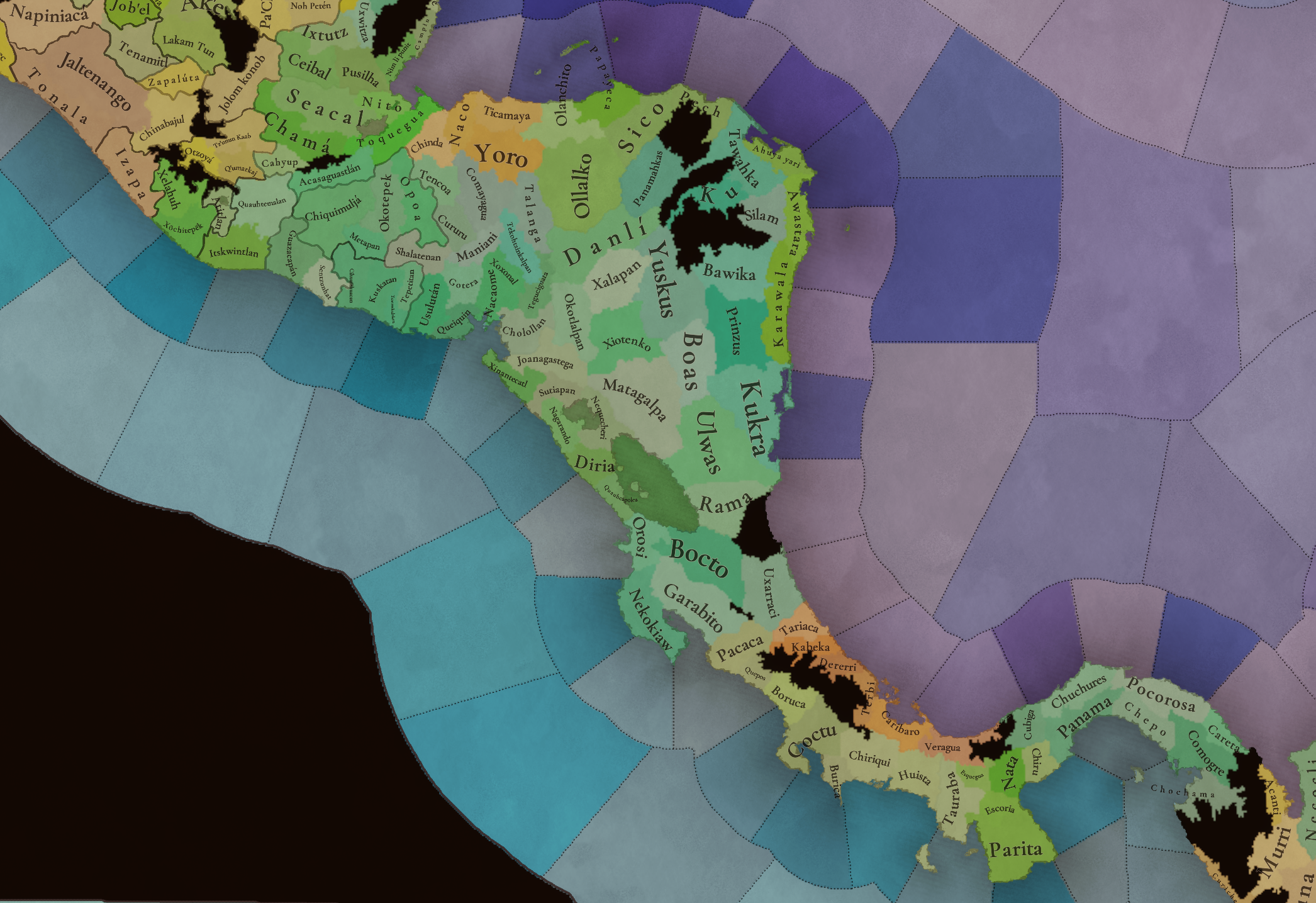
Hello everybody, and welcome to Tinto Maps, the happy Fridays for map lovers! Today, we will be looking at Central America, which includes the Caribbean. Before we start, I want to introduce you @RaulTrullenque , the only member of our Content Design team who had not yet gone public, and who worked really hard on the maps and content of the Central American and South American regions.

And now let’s get started without further ado!

Countries
Countries1.png

Countries2.png

Countries3.png

Countries4.png

Countries5.png

Countries6.png

Countries7.png

Tenochtitlan.png

Mayan.png
Welcome to the Mesoamerican Thunder Dome! This area is characterized by its numerous Altepetl, more or less comparable to city-states. Most of them are ruled in 1337 by peoples of Nahua origin, something that you may see much more clearly in the culture map. The biggest power in this moment is the Empire of P’urhépecherio, though, founded by the Purepecha people. In any case, you may notice that there’s a lot of detail in this area, including a tiny Nahua settlement recently founded on an island over Lake Texcoco, Tenochtitlan. This is the first time in a PDX GSG that we have the island itself present on the map, although the location covers some more land over the lake coast, to make it playable. Finally, we also have the Mayan polities of the Postclassic Period, of which Cocom, with its capital Màayapáan, was the most important, along with others, such as K’iche’ and its capital Q’umarkaj.

SoPs
SoPs1.png

SoPs2.png

SoPs3.png

SoPs4.png
On the outskirts of the Mesoamerican polities, there are plenty of peoples organized on different ways. To the north, we have the ones that populate the area known as Aridoamerica, which were collectively termed by the Nahua as ‘Chichimeca’. We also have plenty of societies close to the Mayan lands and the Isthmus. And, finally, the Taíno people populate some of the biggest islands in the Caribbean.

Locations
Locations1.png

Locations2.png

Locations3.png

Locations4.png

Locations5.png

Locations6.png

Locations7.png

Locations8.png

Plenty of locations here! I just want no note that the Darien Gap is an impassable wasteland, which means that any army trying to cross from modern Panama and Colombia will need transport ships to be able to do it.

Provinces
Provinces1.png

Provinces2.png


Areas
Areas1.png

Areas2.png


Terrain
Climate.png

Climate2.png

Topography.png

Vegetation.png

Vegetation2.png

A very diverse region! Most of it is covered by Tropical Jungles and Forests, but Sierra Madre Occidental and Oriental make for very specific conditions in the Mexican Altiplano, which are not only visible in the Topography map but also in the climate and vegetation of the area.

Development
Development2.png

The most developed regions in Mesoamerica are the Valley of Mexico and the Mayan coastline.

Natural Harbors
Harbors.png

There are some good ports in the Caribbean, no surprise that most of them would later become important cities in the Colonial Period.

Culture
Cultures.png

Cultures2.png

Tons of cultures!

Language
Dominant Languages1.png

Dominant Languages2.png

Court Language.png

And also languages! The first two maps are the Dominant Languages per location, while the third is the Court Languages one. The dark blue language is ‘Totozoquean’, as it is not so easily readable (something we have to change).

Religions
Religions.png

This map is today in a more advanced state, as we have merged plenty of cultural religions into regional groupings. Of these, Tonalism, Nahua, and Mayan are part of the Tonalist religious groups, while the others are part of the Folk American group (a regional split of the former ‘Animist’ group). Nahua and Mayan have their different mechanics, which we’ll talk about in future Tinto Talks. Let us know what do you think of this design and any suggestions about the religious grouping!

Raw Materials
Raw Materials1.png

Raw Materials2.png

Raw Materials3.png

Raw Materials4.png

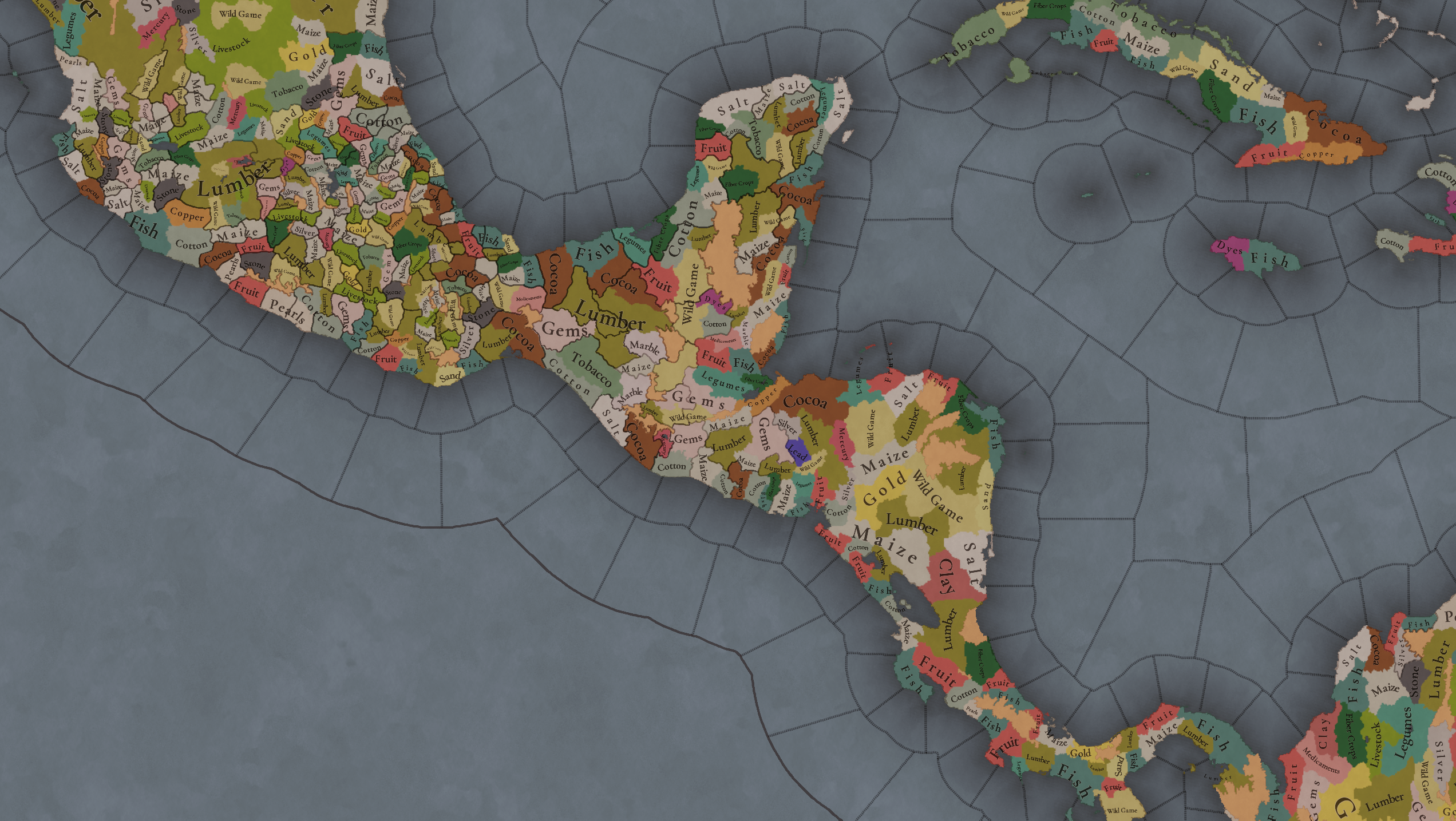
Maize is king in Mesoamerica, although there are plenty of other resources, including juicy Gold and Silver. Obsidian is not a separate resource, as it’s too regional-specific, so it’s included under the Gem coverage, but we have ways to represent it in-game; for instance, there’s a production method to produce Weaponry using Gems as an input.

Markets
Markets.png

A couple of bugs were reported while taking the screenshot of this map! But well, you can see that Azcapotzalco, Màayapáan, and Noh Petén (capital of the Itza people) are the most important ones.

Population
Population1.png

Population2.png

Population3.png

Population4.png

Population5.png

Population6.png

Population7.png

We have solved a couple of issues with the pop editor, and this week this map is in a decent state to be shown! Yay! Total numbers in the region are roughly 8.6M pops, distributed this way:
  • 523K in Aridoamerica (includes the lands to the North-West of the Purepecha Empire)
  • 6.947M in Mesoamerica (including North-Western Mayan lands)
  • 1.003M in Central America (including South-Eastern Mayan lands)
  • 151K in the Caribbean Islands

And that’s all for today! We hope you enjoyed these meaty maps! Next week we will be taking a look at the Levant Feedback, on Monday 16th, and South America, on Friday 20th! Cheers!
 
  • 118Like
  • 96Love
  • 5
  • 1
Reactions:
In the off chance that someone hasn't mentioned this:

San Andres & Providencia should be added to the map as a location. There's a lot of interesting history as the Spanish and English fought over these islands in the 17th and 18th centuries.

Also, Tortuga would be great as a pirate republic, and the English, French, Dutch and Spanish all fought over this island at various points.

And Roatan should also be added for similar reasons.

While these are small islands they were significant and (in)famous pirate havens during the golden age of piracy. Ditto for Nosy Boraha/Sainte-Marie off Madagascar. You can scale up these islands a bit so they're easier to click on.
 
  • 6Like
Reactions:
"Things SHOULD be this way and there SHOULD not be a debate and anyone who disagrees with me might not be mentally okay."

To be honest, I mostly agree with you about Tenochtitlan itself, it would be way cooler if it was an island. Practically speaking that might be more difficult - Hormuz (or rather Qeshm) in particular is a bad comparison due to being 100x larger.

But insinuating that other people are mentally ill just because they have reasons different from yours or mine is not the way to go.
Things aren't supposed to be this way. That's how they were back then. It's not my whim, you make it seem like it is. If we want to have a good video game, we should make these kinds of complaints about what needs to be fixed and so on to make it as realistic and historical as possible. Because if that's not the idea, then just add unicorns and dragons to the game. I think we're all looking for a game that's historically realistic. For everything else, we already have thousands and thousands of games.

And that's what my criticism is about. It's not possible for small errors and other things to be corrected for other regions (mainly Europe). For example, someone doesn't have their hometown represented, and they want to integrate it into the game, which has no impact on the gameplay or the story, and it wasn't important in the period the game covers. Meanwhile, other more important aspects, such as the conquest of Tenochtitlán and its historical representation, which is a fundamental part of the story, are left out.
 
  • 1Like
Reactions:
Things aren't supposed to be this way. That's how they were back then. It's not my whim, you make it seem like it is. If we want to have a good video game, we should make these kinds of complaints about what needs to be fixed and so on to make it as realistic and historical as possible.
That's great and all, but Tenochtitlan island is literally going to be 3 pixels if added accurately.

By contrast, Venice can have Lido, Pellestrina, Sant'Erasmo, Murano, etc. Enough for probably about 30 pixels. The devs have a soft lower limit of 100 pixels. For something like Venice, where it's a third of the required size, it's not unreasonable to make an exception. On the other hand, being 3 pixels wide will make Tenochtitlan basically unclickable. Do you really want a location as important as Tenochtitlan to be unclickable?
I suppose you can take away pixels from the lake and have a "Tenochtitlan with peak chinampas" of sorts, it might be large enough for 10-20 pixels. Still very iffy, and it requires a good bit of realism to be sacrificed (draining a deep lake is not particularly easy, and would be borderline undoable by pre-industrial engineering).

Qeshm, included in Hormuz, is roughly 400 pixels.
 
  • 4
  • 2
Reactions:
That's great and all, but Tenochtitlan island is literally going to be 3 pixels if added accurately.

By contrast, Venice can have Lido, Pellestrina, Sant'Erasmo, Murano, etc. Enough for probably about 30 pixels. The devs have a soft lower limit of 100 pixels. For something like Venice, where it's a third of the required size, it's not unreasonable to make an exception. On the other hand, being 3 pixels wide will make Tenochtitlan basically unclickable. Do you really want a location as important as Tenochtitlan to be unclickable?
I suppose you can take away pixels from the lake and have a "Tenochtitlan with peak chinampas" of sorts, it might be large enough for 10-20 pixels. Still very iffy, and it requires a good bit of realism to be sacrificed (draining a deep lake is not particularly easy, and would be borderline undoable by pre-industrial engineering).

Qeshm, included in Hormuz, is roughly 400 pixels.

IMG_9728.jpeg


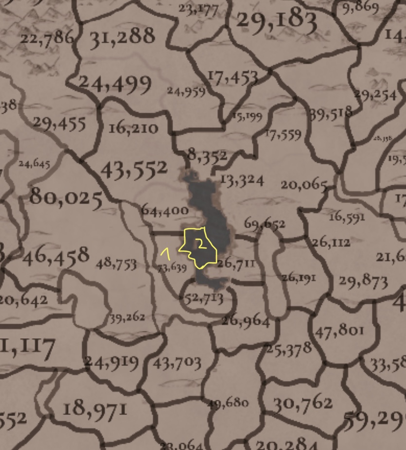
It isnt that hard dude, only thing they need to do is increasing hitbox of Island to the (2), and leave (1) as Tlacopan location

The Hitbox around the lake will still have lake graphics, but it will be functionally part of location for the sake of ease of clicking
 
  • 2
Reactions:
View attachment 1301978

It isnt that hard dude, only thing they need to do is increasing hitbox of Island to the (2), and leave (1) as Tlacopan location

The Hitbox around the lake will still have lake graphics, but it will be functionally part of location for the sake of ease of clicking

I think if you added the other islands and the chinampas, and then stretched the location's boundaries onto the lake slightly, that could work. It would be something like 30 pixels, which is iffy but Tinto did say they were willing to make exceptions.
I just wouldn't want to be the person clicking in the middle of a lake far away from any land and still having Tenochtitlan pop up.
1747620445702.png
 
  • 4Like
  • 1
Reactions:
Eso es genial y todo, pero la isla de Tenochtitlan literalmente tendrá 3 píxeles si se agrega con precisión.

En cambio, Venecia puede tener Lido, Pellestrina, Sant'Erasmo, Murano, etc. Suficiente para unos 30 píxeles. Los desarrolladores tienen un límite inferior flexible de 100 píxeles. Para un lugar como Venecia, donde es un tercio del tamaño requerido, no es descabellado hacer una excepción. Por otro lado, tener 3 píxeles de ancho hará que Tenochtitlán sea prácticamente imposible de cliquear. ¿De verdad quieres que un lugar tan importante como Tenochtitlán sea imposible de cliquear?
Supongo que se pueden quitar píxeles del lago y obtener una especie de "Tenochtitlán con chinampas en la cima". Podría ser lo suficientemente grande para 10-20 píxeles. Aun así, es muy dudoso, y requiere sacrificar bastante realismo (drenar un lago profundo no es particularmente fácil y sería prácticamente imposible con la ingeniería preindustrial).

Qeshm, incluida en Ormuz, tiene aproximadamente 400 píxeles.
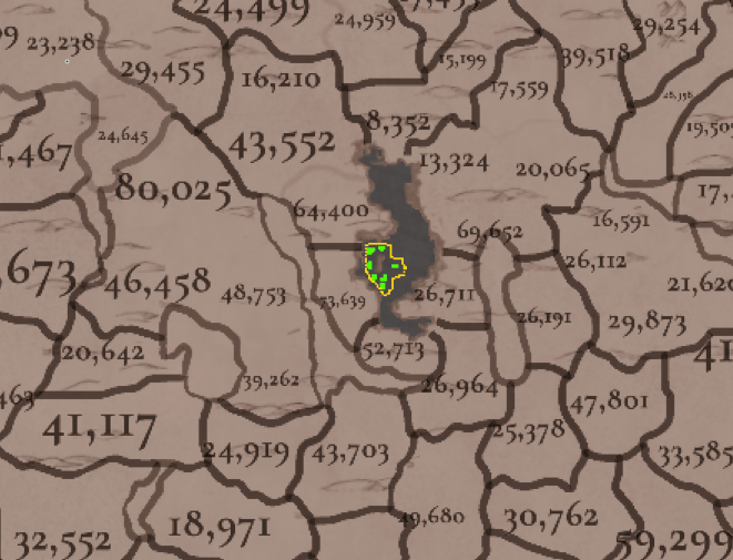
No entiendo esto de los píxeles, pero digitalicé casi todas las ubicaciones de la Cuenca de México con un software SIG. Observo que la superficie de la isla de Tenochtitlán es aproximadamente la mitad de la de Xochimilco (en verde justo debajo), y creo que la siguiente imagen podría ser una opción viable:
Captura de pantalla 2025-05-19 161628.png


Debo aclarar que esto es solo un breve resumen; Aún son posibles muchas mejoras. Por ejemplo, la región occidental (cerca de Azcapotzalco y la actual Tenochtitlán), donde existen zonas intransitables, solo tiene una montaña (el Nevado de Toluca). En el siglo XVI, mexicas y purépechas se cruzaron para atacarse mutuamente. Por lo tanto, es un tanto inexacto describirla como una zona intransitable.

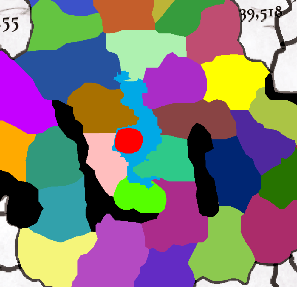
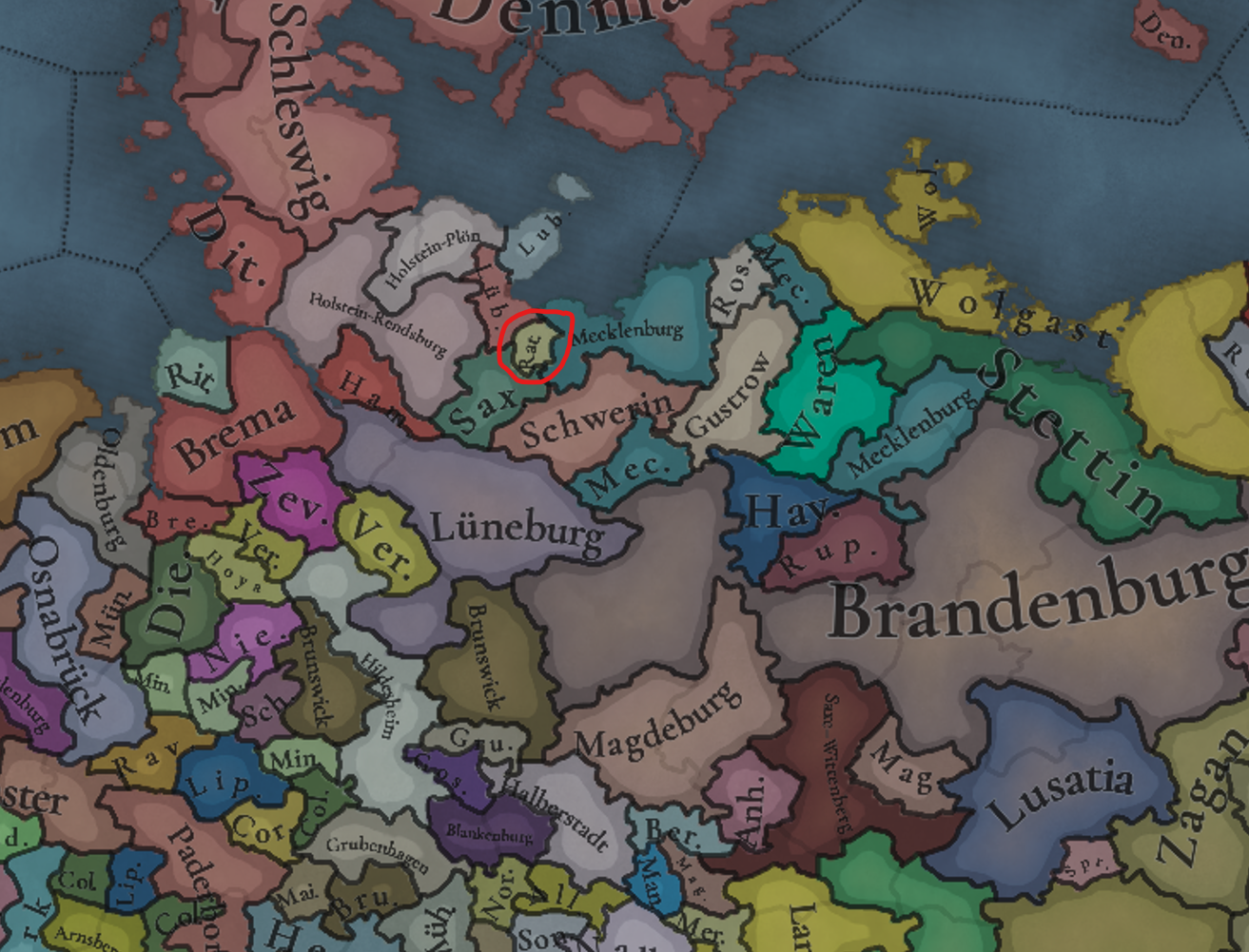
Además, tomando como ejemplo el Sacro Imperio Romano Germánico, hay localidades y entidades políticas muy, muy pequeñas, como la que os muestro a continuación (resaltada en rojo cerca de Lübeck) y tendríais que ver cuántos píxeles tiene:

SIR.png
 
Last edited:
  • 2Like
Reactions:
I don't understand this pixel thing
Devs said that they have a soft minimum for the number of pixels each location can have, and will only make exceptions for special locations.

The map is 16384x8192 pixels. I did the math a while back and this translates to roughly 1.9x1.9km per pixel.
I think the following image might be a viable option
That's almost exactly what I suggested, plus/minus a few pixels, so yeah, I wouldn't really complain.
 
  • 1Like
Reactions:
Los desarrolladores dijeron que tienen un mínimo flexible para la cantidad de píxeles que puede tener cada ubicación y que solo harán excepciones para ubicaciones especiales.

El mapa mide 16384 x 8192 píxeles. Hice los cálculos hace un tiempo y esto equivale aproximadamente a 1,9 x 1,9 km por píxel.

Eso es casi exactamente lo que sugerí, más/menos unos pocos píxeles, así que sí, realmente no me quejaría.
Bueno, si averiguas cuántos pixeles abarca la provincia de Xochimilco, mi propuesta para Tenochtitlan será aproximadamente el 0.45 de su tamaño.
 
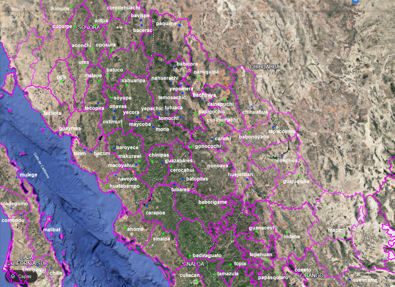
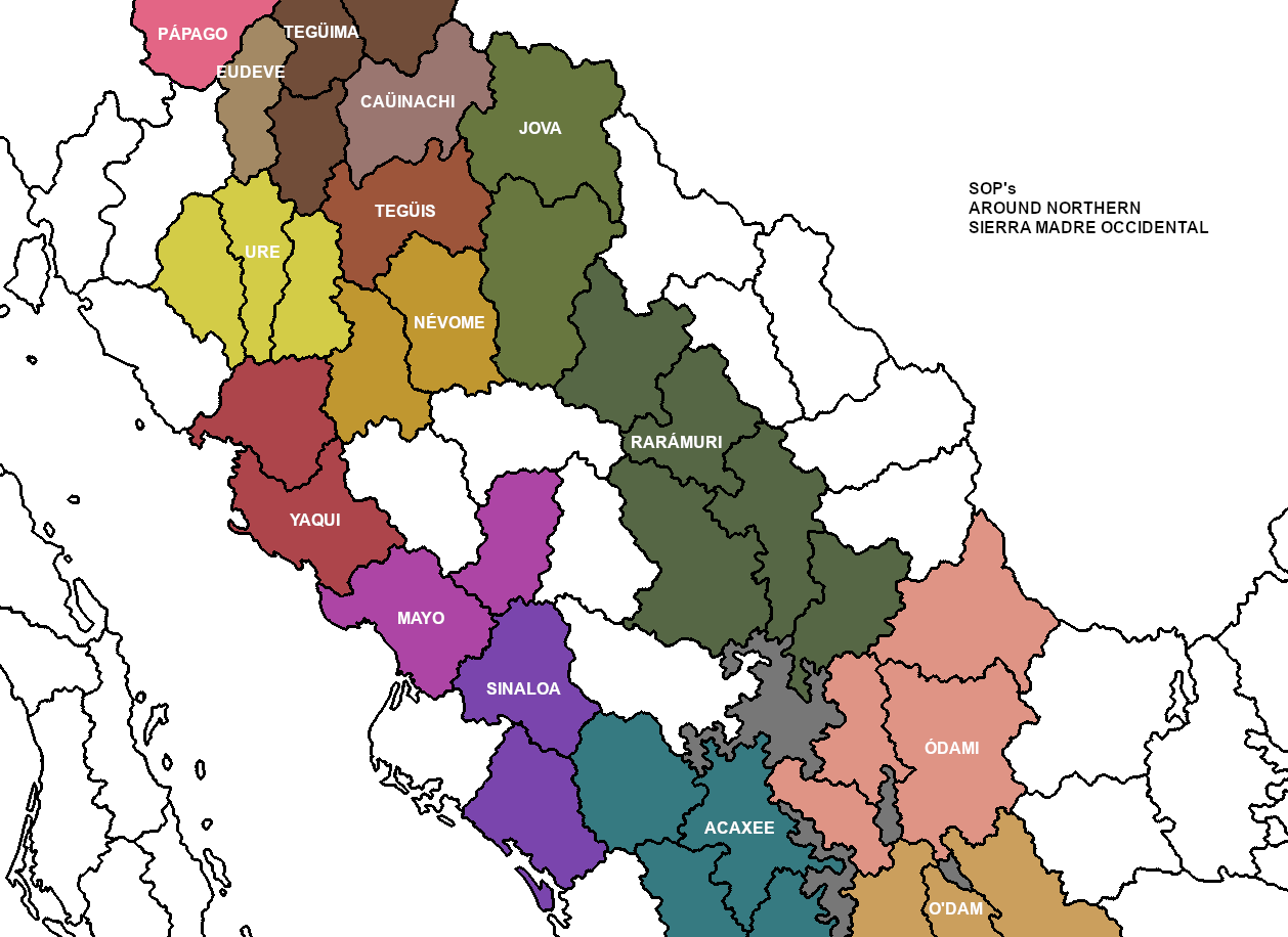
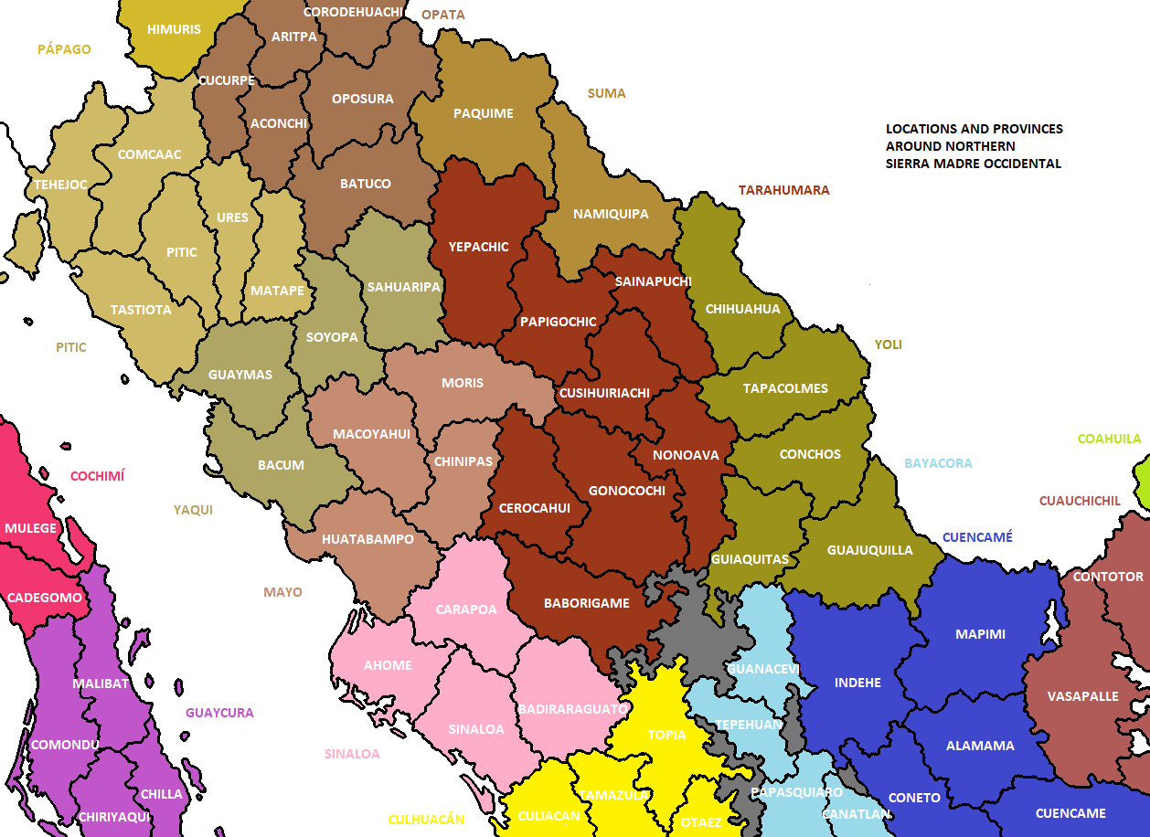
Working on the SoPs for Western Mexico I stumble upon the problem of the Cahita peoples of northern Sinaloa, southern Sonora and the Chihuahuan frontier. So a more broader review of the Northern Sierra Madre Occidental was needed. The next map shows most of the relevant sites to consider (green stars devs locations and blue stars additional suggestions) and their redrawn forms:
Cahitas Sonora.png


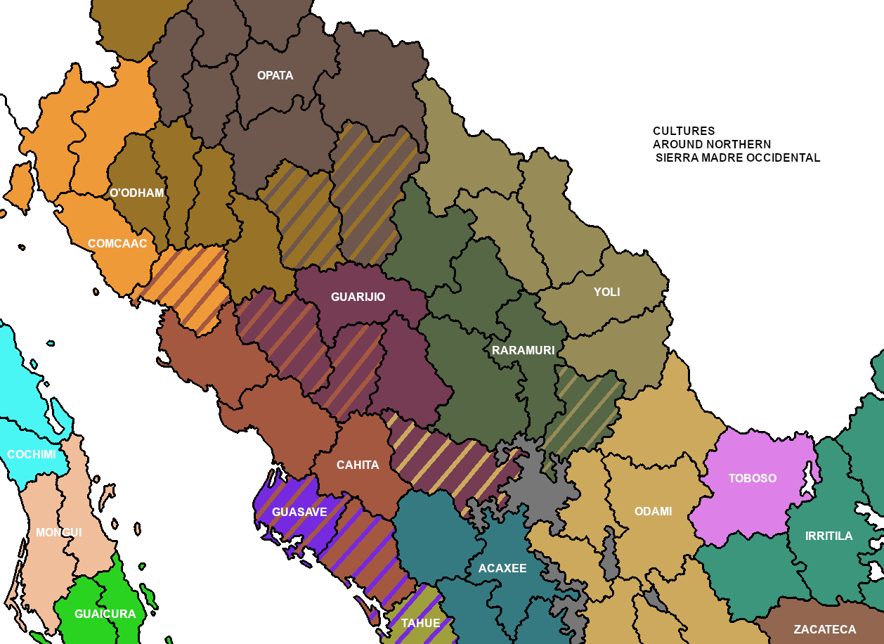
Some sources classify as Cahita multiple small nations but the only certain are Yaqui, Mayo, Tehueco, Zuaque and Sinaloa peoples. The current Yaqui and Mayo are so closely related even now that it would be fitting to share the same Cahita culture instead of separated ones, this way the Sinaloa SoP could be added also. This considering that the Sinaloa, Zuaque and Tehueco shared a smaller area around the current rivers Mocorito, Sinaloa and El Fuerte (also named Sinaloa, Zuaque and Carapoa earlier). That area was also shared in the coastal zones with the Guasave, Ahome and Achire nations, tentatively related to the Seri (Comcaac) people. So considering the complexity and importance of northern Sinaloa I insist on the need to split off the Ahome locality into Ahome (coastal) and Carapoa (inland), representing with the Sinaloa the rest of the Sinaloan Cahitas. Meanwhile Guasave can keep the Ahome locality plus minorities in Sinaloa and Culiacan localities, still similarly to the Seri the Guasave society would not need to be represented as a proper SoP.

Cahitas cultures.png


At the mountainous region between Sinaloa, Sonora and Chihuahua there were multiple
small nations like the Tubar, Huite, Temori, Guazapar, Chinipa, Macoyahui, Conicari, Tepahue and Varohio, this last one are also named Guarijio (that includes the Macuware) and are the only ones currently keeping their unique identity. The rest were likely assimilated into them, the Cahitas and Tarahumaras (Rarámuri). So the Guarijio (Warihio) culture would represent all these “inter Cahita-Tarahumara” nations.

Cahitas SOPS.png


Talking about the Rarámuri, they like the Cahitas expanded over their neighborhoods later, so their starting area is reduced. Meanwhile the Jova nation needed a bigger correction, since their territory was more to the north (of course affiliation of the declining Paquime is debatable but Jova is one of the most likely options). At the starting date the Opata people covered the northern part of the locations disputed with the southern Pima. Talking about the Pima, their culture could be better be named as O’odham, and the southern Pimas being divided into the SoP’s of Ure at the lowlands and the highlander Névome. Similarly the Tepehuan could be divided into the northern Tepehuan Odami and the southern Tepehuan O´dam.

Cahitas locations.png


Finally some localities changing names to historical sites are; “Xiica xnaai iic coii” to Tastiota, Yoreme to Bacum, Makuráwe to Macoyahui, Cosihuiriachi to Moris, Cocoyome to Cusihuiriachi, O’oba to Yepachic, “Hue hue ri gita” to Paquimé, “Ja’e aayá” to Chihuahua, Babonoyaba to Tapacolmes, and Mesquite to Conchos (this last one is historically more relevant even if is highly hispanic but Mesquite it is also, so). By the way there is the option to take away the “s” from the plural form of many hispanized site names.

REFERENCES:

Almanza-Acalde, H., Carreón-Arias, S. D., Castillo-Cuevas, S., Loera-González, J. J., Ortega-Balderrama, L., Palacio-Flores, G. and Sánchez-García, H. C. The O’oba Yumare (Low-Lying Mountain Pimas) and their Oral Tradition. Sistema de Información Cultural.

Capello-Sanchez, K. 1996. Las Misiones Jesuíticas y el Proceso de Aculturación Religiosa de los Grupos Cahitas (1591-1650). Universidad Autónoma de México.

Cramaussel, C., and Ortelli, C. C. 2007. La Sierra Tepehuana. Asentamientos y movimientos de población. El Colegio de Michoacán. Universidad Juárez del Estado de Durango.

Gerhard, P. 1996. La frontera norte de la Nueva España. Universidad Autónoma de México.

González-Kaiser, G. G. 2018. El Arte de la lengua Tegüima, vulgarmente llamada Ópata de Natal Lombardo: Una fuente para el estudio histórico de la Opatería en el siglo XVII. Universidad Nacional Autónoma de México.

Griffin, W. B. 1969. Culture Change and Shifting Populations in Central Northern Mexico. The University of Arizona.

Hinton, T. B. 1959. A survey of Indian assimilation in Eastern Sonora. University of Arizona.

López-Aceves, H. 2007. Los Mayos de Sinaloa: Esbozo etnográfico y regional. Cuicuilco. vol. 14. nº39. pp. 11-33.

Ponce de León, J. M. Nombres geográficos de origen Tarahumara, usados en el Estado de Chihuahua.

Radding, C. 2023. The Yoreme Creation of Itom Ania in Northwestern Mexico: Histories of Cultural Landscapes. Living with Nature, Cherishing Language. pp. 125-152.

Rangel-Guzmán, E, and Marín-García, J. L. 2014. Desplazamientos territoriales y nuevos asentamientos Tepehuanes. Relaciones. Estudios de historia y sociedad. vol. 35. nº 137.

Reyes-Landa, M. L. 2011. Continuidad y cambio cultural en los grupos nómadas del norte de Nueva Vizcaya. Universidad Michoacana de San Nicolás de Hidalgo.

Yetman, D. A. 2010. The Ópatas. In Search of a Sonoran People. University of Arizona.
 
  • 4
  • 1Like
Reactions:
1747834742281.png

1747834755824.png
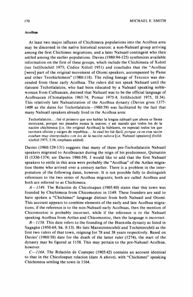
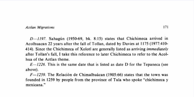
Source: Smith, Michael E. The Aztlan Migrations of the Nahuatl Chronicles: Myth or History? (1984)

1747850010556.png
Source: Davies, Nigel. The Aztecs: A History (1980) p. 315

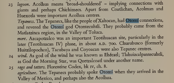
So it would seem that Texcoco in 1337 should have Otomi as its primary culture or at least court language, and demographically should be a mix of Otomi and Nahua along with some Chichimec (most likely Pame) minorities. When Quinantzin dies and is succeeded, there could be a flavor event to switch the primary culture to Nahua and begin assimilating the Otomi.

The Tepanecs as well seem to have an Otomi or perhaps Matlatzinca connection. Consider also that the relaciones geograficas recorded Otomi and Chichimec being spoken in Tlacopan (another Tepanec city besides Azcapotzalco) in 1579 along with Nahuatl. Barring further details, Azcapotzalco can keep Nahua as its primary culture, but both it and Tlacopan should have mixed Otomi-Nahua populations.
 
Last edited:
  • 5
Reactions:
Is there any info on what would happen if the player managed to get in contact with Andean natives before the Europeans arrive? Would a mini "Columbian exchange" happen where the region could get access to wool RGO's early?
Edit: grammar
 
Last edited:
Thanks. About languages:
The Teco was almost for sure an Uto-Aztecan language, Coca seems probably. For Xilotlanzinca are two hypothesis, the firts being related to Nahua but this could be because their use of "mexicano corrupto" as lingua franca and the second one that Xilotlanzinca was a synonym with Piñol therefore "Otomi-like". Pinome including "Otomi" likely was Oto-Manguean, while "Pampuchin" (as a regional umbrella) is the one with less sources to figure their relation. For Chontal it seems to be a good possibility to be Otopamean.

For a concise culture grouping suggestion I would like to wait to analyze the rest of PC's Mesoamerica, still some points that I have in mind are:
- Since languages are their own category in PC (unlike EU4) we could depend less on language for culture grouping. For example the Chichimeca culture group including both "Aztecoid" and Otopamean speaking cultures.
- The traditional Mesoamerican regional classification could be the base, for example Western Mesoamerica with its roots in previous traditions like Chupicuaro and Teuchitlán.
- Keep in mind the practical consequences of PC's culture mechanics, so we can expect "historical-like" results from the cultural scale and grouping.


Cora and Huichol are better as separated cultures, the main reason I had before to mix them was just to secure their historical survival, since having more pops mean have more relative weight, but I guess some events could help with it.


Here is the map and table with the addition of most of these suggestions.
View attachment 1289331

58TenamaxtlánTenamaxtlanNahua (Cuyuteca)Pampuchin
146CutzeoCutzeoMatlatzincaPurepechaChontal
153ArimaoArimaoPurepechaNahuaChumbia
156CoalcománCoalcomanXilotlantzincaNahua
158TecománColimaNahuaXilotlantzinca
159CollimanColimaNahuaXilotlantzincaPinome
160TepetitiangoColimaNahuaPinome
162ZirandaroZirandaroChumbiaPurepechaChontal
163PungarihuatoPungarihuatoCuitlatecaPurepechaChontal
172TetellanTetellanCuitlatecaTlapanecaChontal
174CutzamalaCutzamalaChontalMatlatzincaCuitlateca

The sources below add references for the presence of Chontales at Cutzeo and Cutzamala, and Cuitlatecas at Cutzamala. The case of Arimao is complicated because the little information we have is about Arimao proper that is at the top of the region near the river Tepalcatepec, meanwhile most of the area that correspond to the locality is the mountanious basin of the river Aguililla, an area that even now is relatively underpopulated, still something that seems likely is the presence of some pre-purepecha and pre-nahua population (Chumbia or Cuauhcomeca?). About "Totonac" at Ameca agree that is unlikely.

SOURCES:
- Favila-Vázquez, M. 2019. La navegación prehispánica: Un sistema de conectividad del paisaje mesoamericano. Modelo de interacción entre la Costa del Pacífico y el Altiplano Central (Postclásico Tardío siglo XVI). Universidad Nacional Autónoma de México.
- Gómez-Lucatero, I. 2013. Ocupación del territorio y marginalidad geográfica en Michoacán. El caso de la Comarca de Aguililla, siglos XVI-XX. Universidad Michoacana de San Nicolás de Hidalgo.
- Vargas-Uribe, G. 2017. Despoblamiento étnico e indígena del obispado de Michoacán: una visión geohistórica (1550-1889). Ciencia Nicolaita. n° 70. pp. 23-43.
Last couple nitpicks (I think):
1748243481071.png


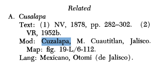
Cuzalapa spoke Otomi and Nahuatl, therefore technically should be Pinome culture instead of Pampuchin

1748243489327.png

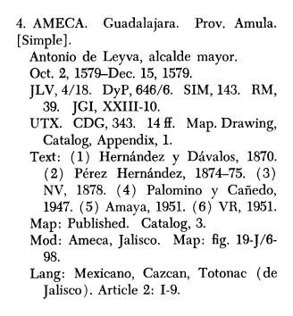
Ameca had Nahuatl, Caxcan and mysterious "Totonac". Doesn't mention Coca but maybe the census just missed them. Though, perhaps the Caxcan presence was in some settlement besides Ameca that was grouped under this province.
 
Last edited:
  • 1
Reactions:
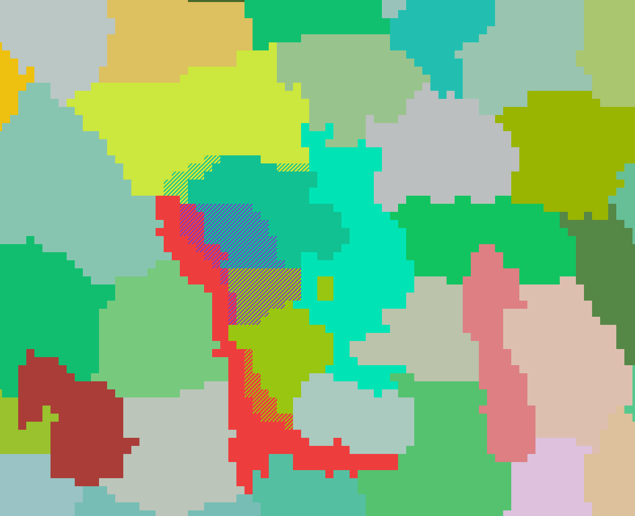
Over the last couple of days, a discussion has taken place in this thread, where I and other people have been talking about what should be done to the area around Lake Tetzcoco. In the end, we came to agree on one of the various proposals, and voting has taken place to decide on the specific version that I would have proposed here. The only difference between the two is how the island Mēxihco-Tenōchtitlan is on should be dealt with.

Goal of the proposal
The goal of this proposed change is the addition of a new location, Tlacopan. As one of the altepetls that were part of the Aztec Triple Alliance, we believe it is relevant enough and thus it deserves representation.

Suggested changes
You can see what we suggest in the following maps:

Tlacopan Added (2).png

True scale pixel map of the area. The purple location is Tlacopan, the only addition.


1748212979059.png

A map of suggested changes. Stripes indicate places that, if this proposal is implemented, would go to another location.

These are the changes to the size of locations, in pixels:
  • Tenōchtitlan: 151 → 124 (-27)
  • Tlacopan: N/A → 134 (Added, +134)
  • Azcapotzalco: 196 → 156 (-40)
  • Cuauhtitlan: 334 → 314 (-20)
  • Wasteland: 210 → 163 (-47)
The only locations that would be below the 150 pixels threashold would be Tenōchtitlan and Tlacopan, but despite their small size they would still be bigger than Xochimilco, which is 114 pixels.

Of course, this could be changed by the devs for whatever reason that would require so. This is just meant to be a guideline.
 
  • 9
  • 3Like
  • 1
Reactions:
Last couple nitpicks (I think):
View attachment 1306747

Cuzalapa spoke Otomi and Nahuatl, therefore technically should be Pinome culture instead of Pampuchin

View attachment 1306748
Ameca had Nahuatl, Caxcan and mysterious "Totonac". Doesn't mention Coca but maybe the census just missed them. Though, perhaps the Caxcan presence was in some settlement besides Ameca that was grouped under this province.
Agree, noted. Gonna be fixed for the updated general suggestion.

Currently I am working on the Aridoameriacan frontier for a more consistent transition to Mesoamerica, but this time the Northeast side (plus the Huasteca region). There Nueva Santander and Nuevo León have a serious case of location's name inconsistency that goes from long hard spelling endonyms to crude spanish apellatives. Native names for proper locations are scarce beyond southern Tamaulipas, especially the historically relevant ones. Even spanish missions are less abundant and use less native naming. By the way I mostly use the hispanized plural form of some native nations since those are the best documented forms for actual locations (missions) under those names, but maybe the singular form could be standardized for these plus the locations that only could use broad tribal domains in the absence of recorded native toponymies.

I mean names like "Bocas Prietas" are far from be ideal, however some are the only avaible options for a few historical group. What do you think?
 
  • 1Like
Reactions:
Agree, noted. Gonna be fixed for the updated general suggestion.

Currently I am working on the Aridoameriacan frontier for a more consistent transition to Mesoamerica, but this time the Northeast side (plus the Huasteca region). There Nueva Santander and Nuevo León have a serious case of location's name inconsistency that goes from long hard spelling endonyms to crude spanish apellatives. Native names for proper locations are scarce beyond southern Tamaulipas, especially the historically relevant ones. Even spanish missions are less abundant and use less native naming. By the way I mostly use the hispanized plural form of some native nations since those are the best documented forms for actual locations (missions) under those names, but maybe the singular form could be standardized for these plus the locations that only could use broad tribal domains in the absence of recorded native toponymies.

I mean names like "Bocas Prietas" are far from be ideal, however some are the only avaible options for a few historical group. What do you think?
I say do your best and don't worry about it too much. At the end of the day it's not mechanically significant, and even if they're colonial, historical options are so much better than just plugging in modern towns. I personally do prefer singular versions of tribe names to avoid Spanish influence but it's no big deal.

Looking forward to seeing it. Do you plan to eventually tackle the core regions of Mesoamerica in the same manner? Even if you don't get to it before the feedback comes out it would probably be useful in the long term, they are going to have to cut a few corners for release but want to clean up regions post-release.
 
  • 1Like
Reactions:
1748986781587.png

1748986813885.png
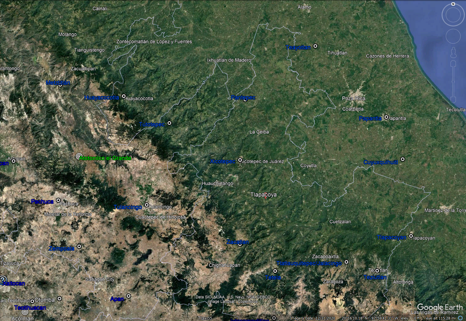
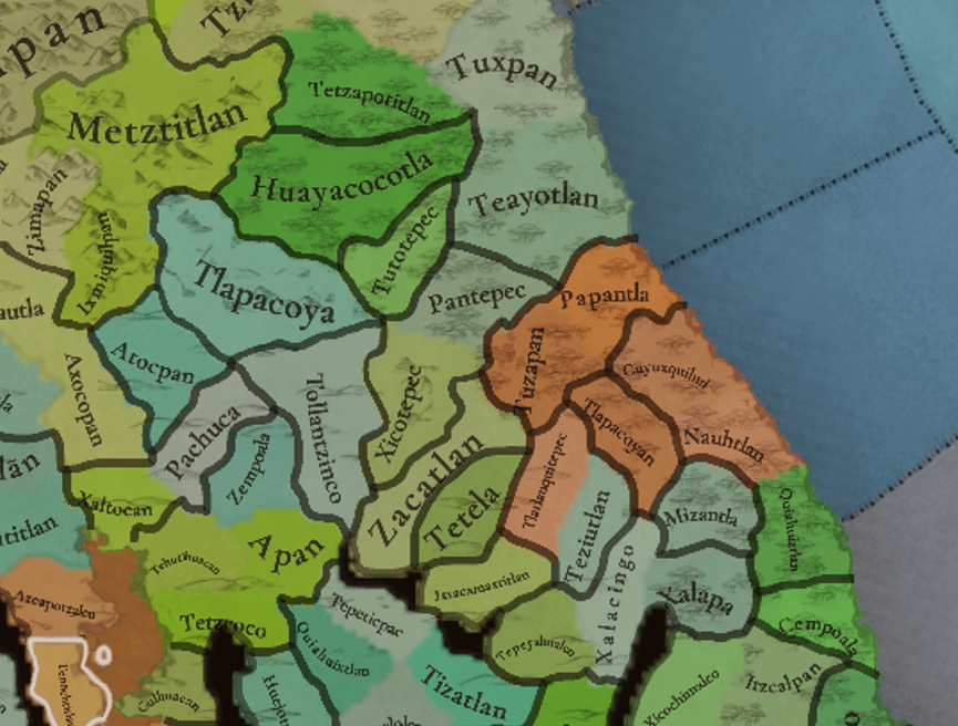
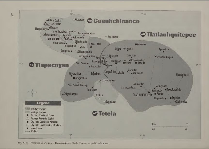
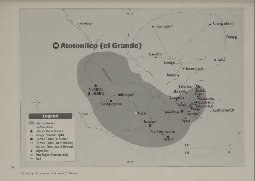
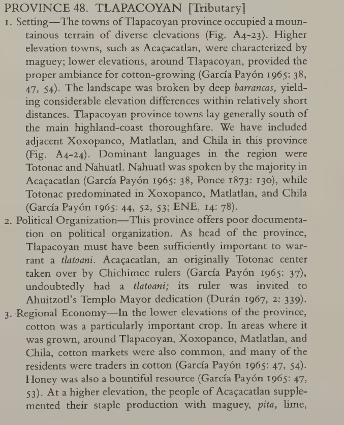
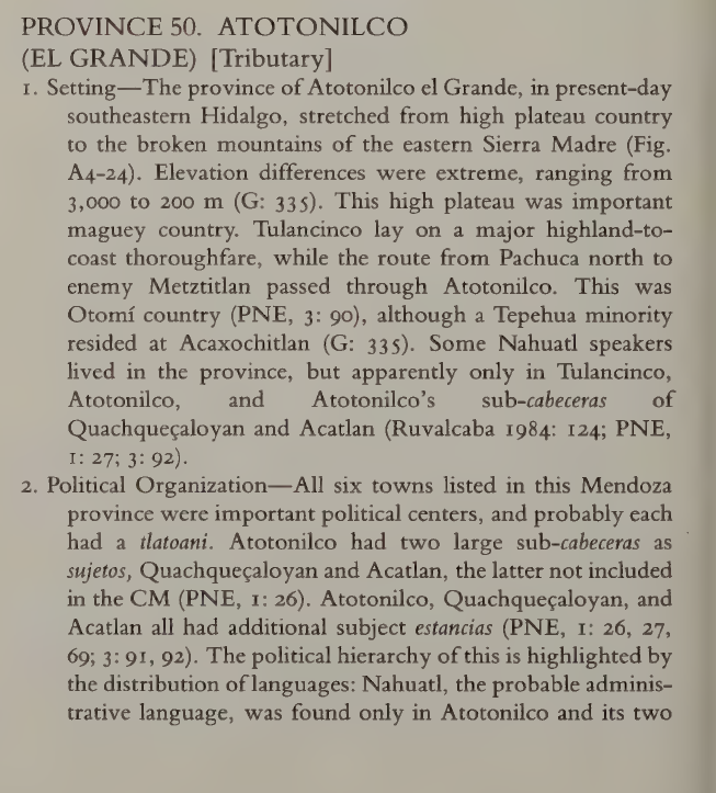
The location of Tlapacoya seems to be in the wrong place? It should be in the northern half of Zacatlan. I suggest creating a new location there, and renaming Tlapacoya to Atotonilco (el Grande). It along with Tulancingo should change to Otomi culture, while the relocated Tlapacoya should be a mix of (Eastern) Nahua and Tutunaku.

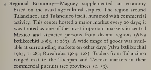
Here are some details from Berdan's Aztec Imperial Strategies (incidentally an absolutely critical source for locations, cultures and raw materials that I might make a master post of soon, as my culture map is undergoing some changes. In any case I highly recommend the devs to check it out)
tlapacoyan.png

atotonilco.png


1748987130790.png

Tlapacoyan should thus be Totonac with a significant (Eastern) Nahua minority and produce either cotton or honey

1748987181213.png

And Atotonilco el Grande should be Otomi/Hñahñu, the later Nahua presence likely being connected to Aztec administration. It should produce fiber crops to represent maguey:
1748987260534.png
 
Last edited:
  • 3Like
  • 1
Reactions:
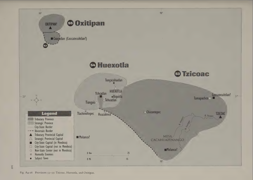
And also based on Aztec Imperial Strategies, I recommend renaming:
  • Pantepec -> Atlan
  • Teayotlan -> Tezapotitlan
  • Tziuhcoac -> Huexotla
  • Tetzapotlan -> Tzicoac/Tziuhcoac
  • Azoyu -> Ometepec, or at least the original Nahuatl Atzoyoc
  • Tecoanapa -> Ayotlan
  • Calixtlahuaca -> Ixtlahuaca
  • Juxtlahuaca -> Tecomaxtlahuacan
  • Oapan -> Tlapan/Tlachinollan
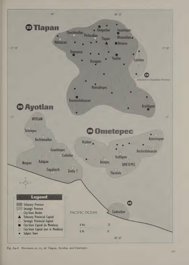
  • Tlapan -> split into Totomixtlahuacan (west) and Acuitlapan (east)
  • Amoltepec -> Zenzontepec
the new ones are the correct provincial capitals for the areas, while the current names are just subject towns. In the cases of Calixtlahuaca, Tetzapotlan, Tziuhcoac, Oapan technically it's more of a geographic consideration.
 
Last edited:
  • 5Like
  • 1
Reactions:
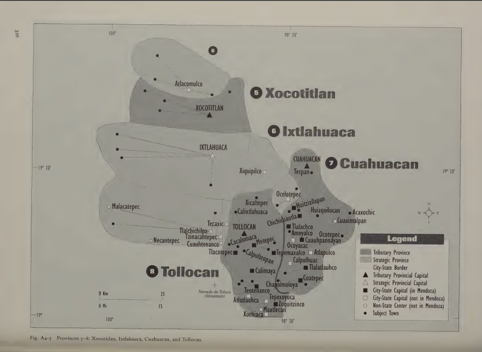
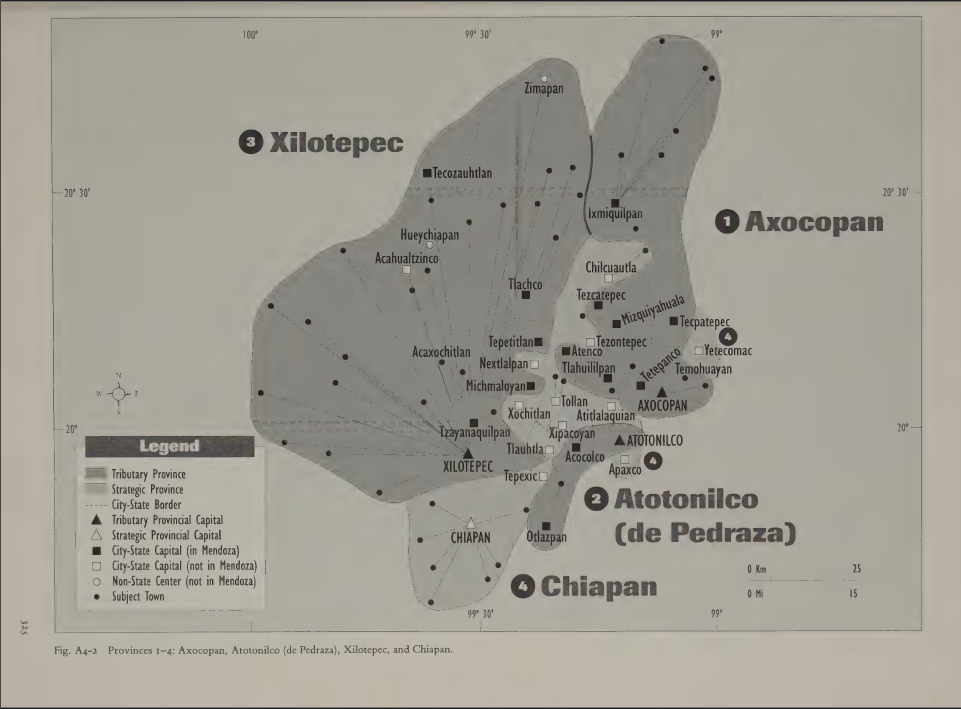
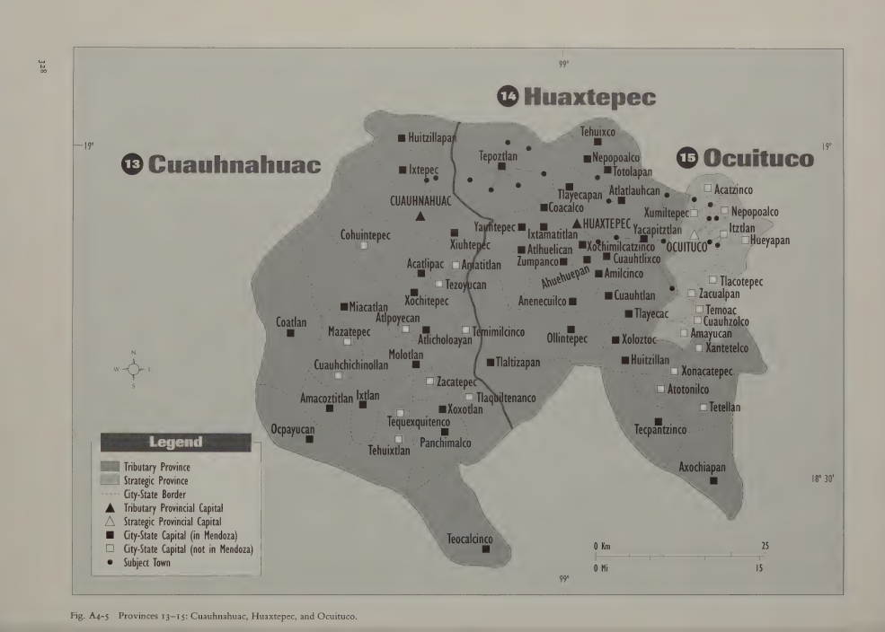
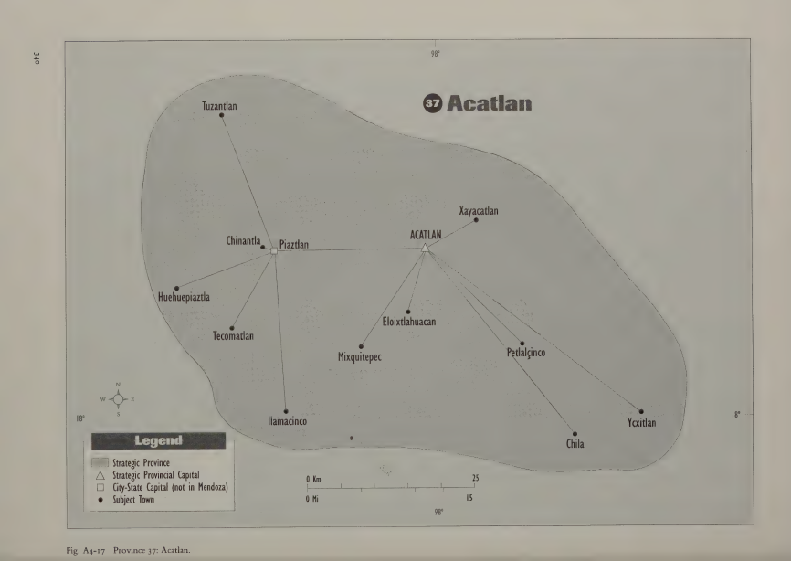
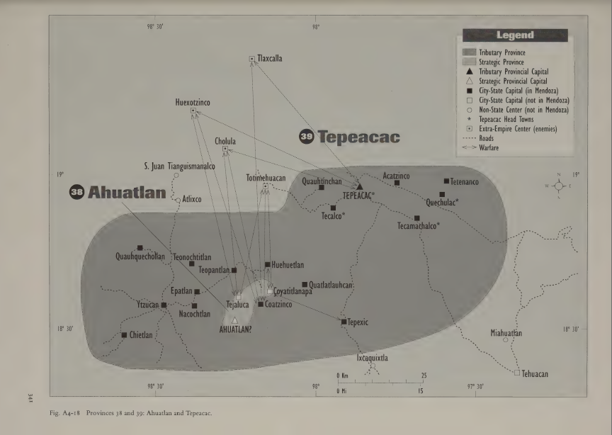
There's also a few Aztec provinces missing that would be nice to add as locations:
  • Acatlan, southern Puebla. Mixtec. Produced salt, cochineal dye, cotton.
  • Ahuatlan, southern Puebla, north of Acatlan. Nahua. Produced wild game, cochineal dye, prickly pear cactus (fruit?)
  • Xocotitlan, Mexico state. Modern Jocotitlan. Populated by a mix of Mazahua, Otomi, Matlatzinca. Produced maguey.
  • Chiapan, Mexico state. Modern day Chapa de Mota. Mix of Nahua and Otomi. Produced maguey, limestone, wood.
  • Cuauhuacan, Mexico state. Modern day Cahuacan. Mix of Nahua, Otomi and Matlatzinca. Produced wood.
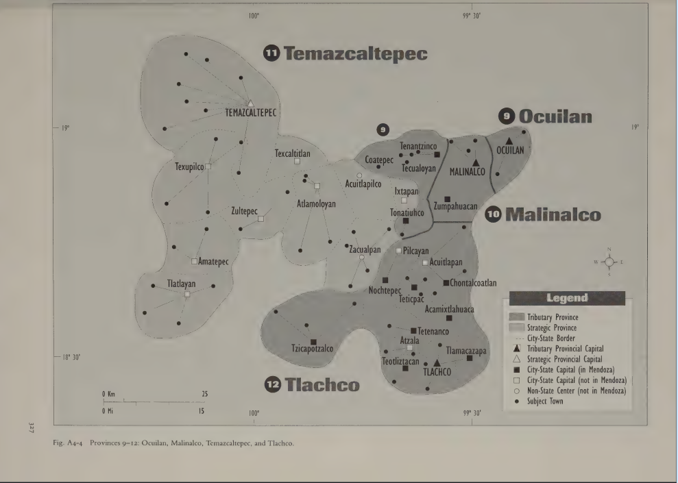
  • Ocuilan, southern Mexico state just to the east of Malinalco. This one would be quite small so I don't expect it. Tlahuica/Ocuiltec, which is related to Matlatzinca. Produced salt.
  • Ocuituco, eastern Morelos. This one is also quite small. Nahua at contact, but perhaps would still have been Tlahuica? Produced flowers and wood.
  • Huexotla, Hidalgo on the border with Veracruz and north of Tziccoac. Modern Huejutla. Was noted as a market center, producing cotton, and populated by a mix of Tepehuas and Nahuas. I wouldn't create a new location but rather rename current Tziuhcoac to this, moving Tziuhcoac to Tetzapotitlan and Tetzapotitlan to Teayotlan.

huasteca.png

toluca.png

xilotepec.png

morelos.png

acatlan.png

tepeaca.png
 
Last edited:
  • 3
  • 1Like
Reactions:
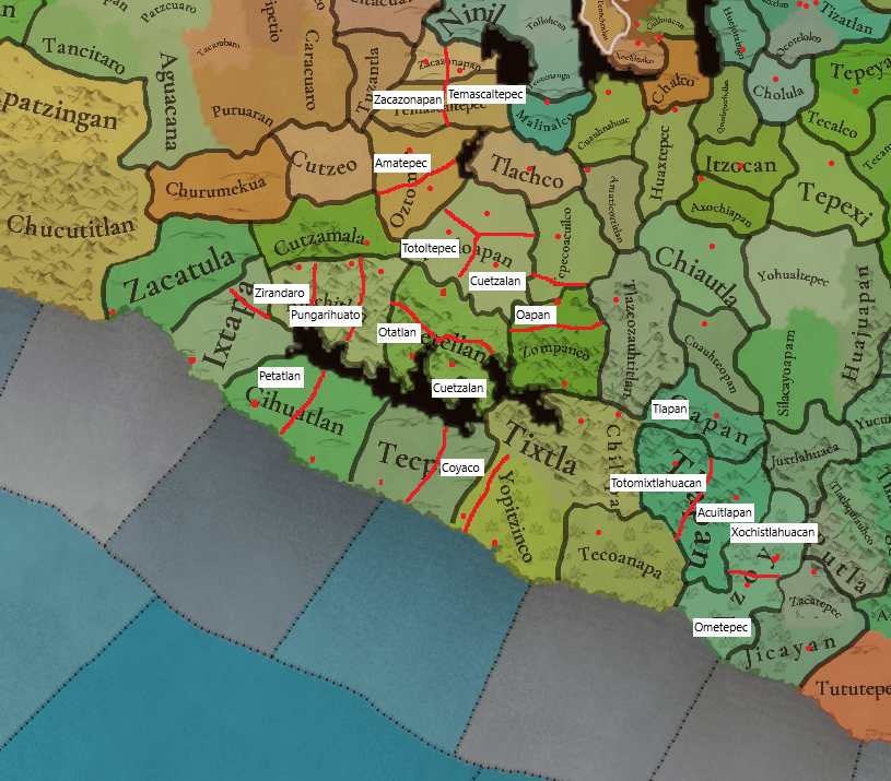
Oapan (in Guerrero) is in the wrong place too, as it refers to modern San Agustin Oapan. It should instead be between Tepecoacuilco and Zompanco. The current Oapan location should become the new Tlapan, and the current Tlapan location, rather large, could be split into Totomixtlahuacan and Acuitlapan. Technically these should probably be OLMs, but I wouldn't really mind that much if you just grouped them under Tlapan (and the new Oapan under Tepecoacuilco). Culturally speaking they can keep the characteristics of their parent location. Totomixtlahuacan should produce either gold or silver.

costa chica.png

tepecoacuilco.png

See Ohuapan in the east, that is EU5's Oapan.
 
Last edited:
  • 2
  • 1Like
Reactions:
Finally I'll suggest a few potential new locations in Guerrero to bring the density up to surrounding regions. Basically, just examine the maps and look for city-states that are far from existing locations.
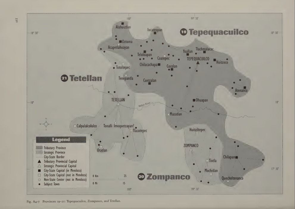
  • Amatepec out of the north of Oztoman
  • Tlacotepec out of the southeast of Tetellan. Culture would be Tlacotepehua with a Nahua minority. Produced gold.
  • Otatlan out of the southwest of Tetellan. Culture would be Tlacotepehua. Produced copper.
  • Cuetzalan out of southeast Teloloapan. Culture would be Nahua, probably with a Chontal minority.
  • Totoltepec out of southwest Teloloapan. Culture would be Chontal with a Nahua minority. Produced jade (gems).
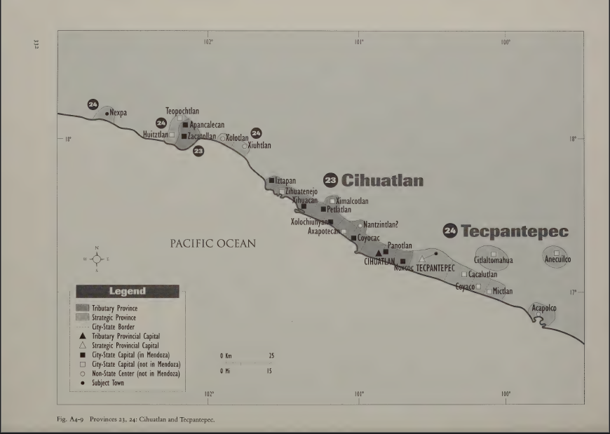
  • Coyocac and Petatlan out of the west of Cihuatlan. The culture would be a mix of Cuitlatec and Tlacotepehua. Produced cacao and gold. Might be tricky to fit both in their correct locations of course, I'm only showing Petatlan on my map.
  • Coyaco between Tecpan and Yopitzinco. The culture would be a mix of Cuitlatec and Tlacotepehua. Produced cacao.
  • Xochistlahuaca out of the north of Azoyu. The culture would be Amuzgo.
  • Totomixtlahuacan (west) and Acuitlapan (east) out of the current Tlapan, as I suggested above. Totomixtlahuacan would be Tlapanec culture, along with some Nahua, and produce gold or silver. Acuitlapan would be Mixtec culture.
  • There's also Zirandaro and Pungarihuato (modern Ciudad Altamirano) that BuchiTaton suggested previously.
The Tlacotepehua group spoke a language called Tepuztec, so while either term would work it seems Tlacotepehua would be the best name for the culture itself.
When we're talking about Nahua culture in Guerrero, they can pretty much all be further specified as the Coixca subgroup, which could be a nice culture to add.

guerrero proposal.png

Went ahead and labelled the rough position of the settlements in question with red dots for reference.

costa grande.png

costa chica.png

tepecoacuilco.png

tasco.png
 
Last edited:
  • 3Like
  • 2
Reactions: