• We have updated our Community Code of Conduct. Please read through the new rules for the forum that are an integral part of Paradox Interactive’s User Agreement.

Tinto Maps #3 - 24th of May 2024 - France

Greetings, and welcome to the third Tinto Maps! Last week we received a great amount of feedback regarding Iberia, which we’re working on, and this week we also reworked the map of the Low Countries, which we’ll show soon.

For this week, we’ll be taking a look at France, up until its current modern borders (which you’ll notice are quite different from the 1337 borders):

Countries:
Countries.png

When portraying the political situation of France in 1337, we had a few options. On one extreme, we could make it a ‘centralized monarchy’, like England or the Iberian ones, but with a much lower degree of control over its territories. Conversely, we could have a ‘French Crown’ IO, similar to the HRE. We decided to go with the middle term, which represents the French Crown lands with the country of France, and its networks of appanages and vassals as different subjects. We think that this way we can portray the progressive centralization of the crown under the reigns of Philip II, Louis IX, and Philip IV, while also portraying the powerful jurisdictional powers of the French feuds. We have two types of subjects in France, by the way: vassals, which represent the regular fief mouvants, and appanages, which were the feuds granted to members of the royal family, that could eventually revert to the French Crown.

You may also notice that there might be a problem incoming related to a couple of English possessions in the mainland, the County of Ponthieu, and, especially, the Duchy of Aquitaine, as well as the Channel Islands of Jersey and Guernsey which comprise a dangerously close non-core location of England (they aren’t big enough to be a worthwhile subject country, even if that might be a more accurate representation).


Locations:
Locations.png

An interesting distribution of locations. Some names may be a bit long, so, please blame the French, not us, and ask if you want to know which location it is.

Provinces:
Provinces.png

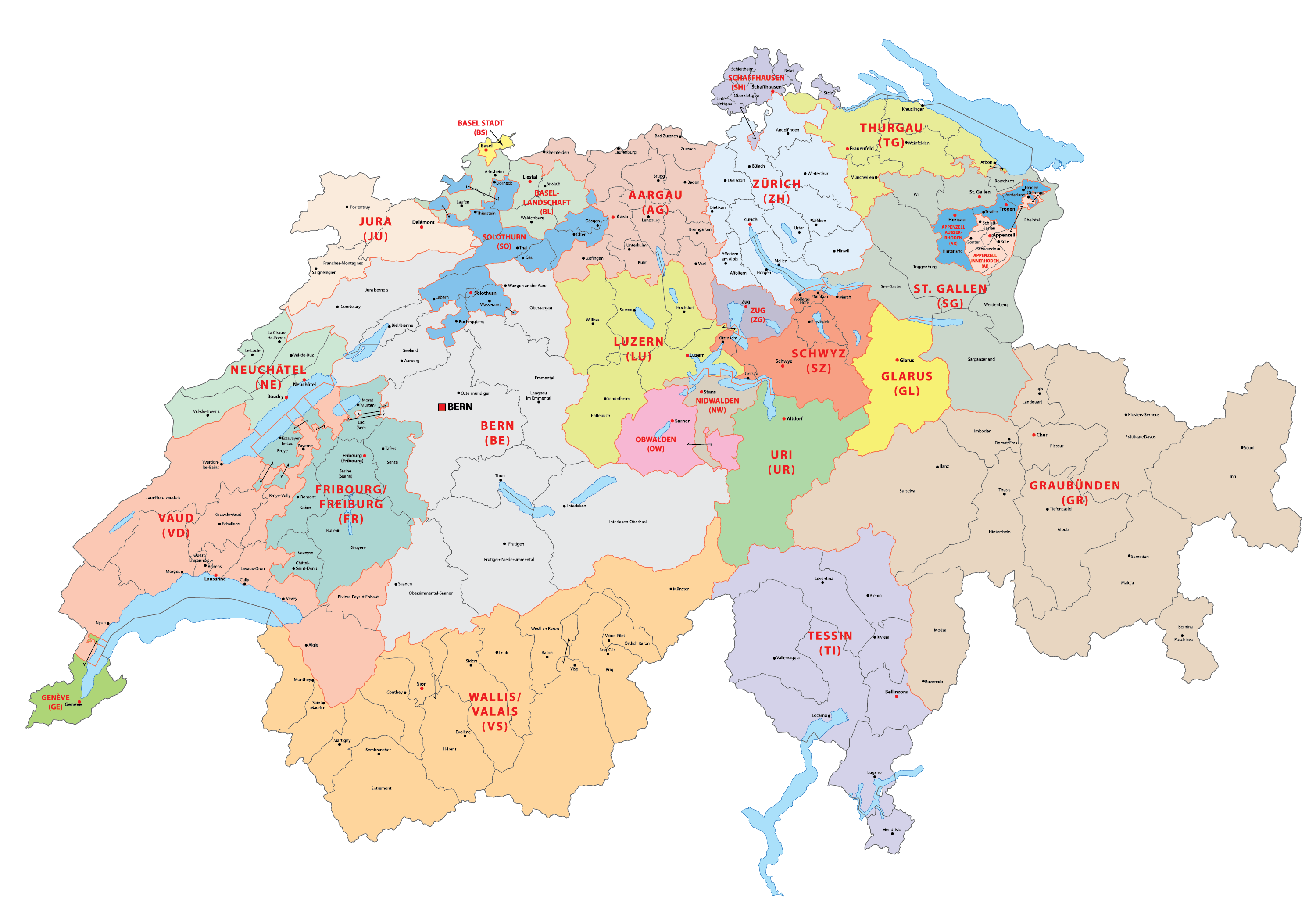
We are aware that we have a severe inconsistency here, which is naming the provinces after locations instead of provincial and regional names (we were not very sure about what naming convention to use when we crafted this map). So we would be glad to receive feedback on the names that you think would fit. E.g.: Artois instead of Arras, Anjou instead of Angers, etc.

Terrain:
Climate.png

Topography.png

Vegetation.png

We’ll also read your feedback regarding the terrain of France, although we already know of some issues to correct (e.g.: changing the vegetation of the Landes to sparse instead of forests.

Cultures:
Cultures.png

Although there are two big cultural divisions of the French cultures, Langue d’Oil and Langue d’Oc, we think that their regional subdivisions would make the situation more accurate for 1337, where there is a long way until the cultural unification of France.

Religions:
Religion.png

Not a very interesting situation, only 0.80% of the population is of a different religion (Judaism). We haven’t portrayed any Catholic heresy yet, maybe Cathars should still have some room in the Languedoc, as Montaillou, an Occitan Village from 1294 to 1324, points to? Also, while taking this screenshot, we improved the view of this map mode, making it more responsive to zoom levels.

Raw Goods:
Raw Goods.png

The gold mines in the center of the map are going to die, as they were exploited only in recent times. Which other changes do you suggest?

Markets:
Markets.png

Paris already had replaced the fairs of Champagne as the main trading center of the region, driven by the growth of the crown lands and the royal power in the 13th century. Apart from that, we have the market at Bordeaux in Aquitaine.

Population:
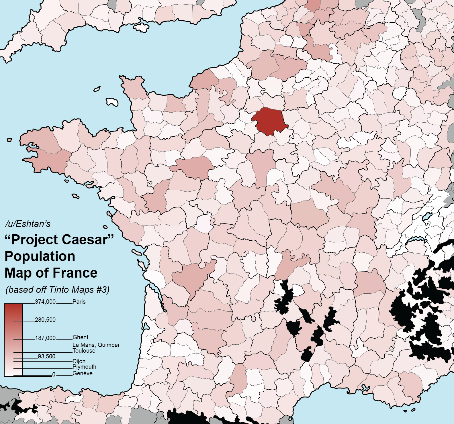
Population.png

Pops with colors.png

Population, and also how it looks with colors when you have the country clicked (Paris, centralizing France since Hugh Capet…).

And that’s all for today! Next week we will move to the North-Eastern part of Europe, as we will take at look at Poland and the Baltic region. Cheers!
 
  • 208Love
  • 167Like
  • 5
  • 4
  • 1Haha
Reactions:
@Pavía
There are some changes to make in Normandy.

Locations :
- rename 'Arcques' to 'Dieppe' (one of the oldest and most important port in medieval Normandy)
- rename 'Tancarville' to 'Fécamp' (one of the oldest and most important port in medieval Normandy)
- rename 'Saint-Lo' to 'Coutances' and enlarge this location a little to the south (Coutances was and is still the siege of the catholic diocese of Coutances. This town also gave its name to the area called 'Cotentin', while Saint-Lô became an important town after the french Revolution)
- Rouen should be a port, like Nantes it's a major port even if it's far from the coast.

Goods :
- Caen should produce stones, 'Caen Stone' is quite important as it was used to build the 'Tower of London', 'Westminster Abbey', and many other building in the norman realm. The quarry is still active today.
- Normandy was always a big producer of iron, but Lisieux and the 'Pays d'Auge' isn't really famous for its iron. I suggest to move Iron from 'Lisieux' to 'Domfront' (iron mines since the Middle Ages in 'La Ferrière-aux-Étangs', in 'Saint-Clair-de-Halouze' and some other settlements, they were closed a few years before the french Revolution and opened back in the late XIXth century). There is also this somewhat relevent historical document about the medieval 'minyere de Beaumont' (a mine in Saint-Rémy, near Falaise). As the normand iron industry decreased in Project Caesar's timeline, I'm not sure it's necessary to have more than one province producing iron. Otherwise, Falaise and Evreux would be better then Lisieux for iron (if iron is added to Falaise, please move the horses to Argentan).
- Avranches should produce salt (lots of saltworks near Avranches and the Mont-saint-Michel). Funny thing there is an hotel near the Mont-saint-Michel called 'Les Quatre Salines' it means 'the 4 saltworks' (not sure this information is relevant but whatever).
- Swap sand from 'Pont-Audemer' to 'Harcourt' as the sandpits are closer to Rouen (along the curves of the Seine, mostly around Jumièges).

Provinces :
here it's tricky, as there are no perfect names.
Cherbourg, Caen, Alençon and Rouen are a good choice. I think you don't need to change, but I'll still add things to think of.
Caen, Alençon and Rouen were the head of the 'Généralités' of Caen, Alençon and Rouen so it's kind of working as names for the provinces. Even if those 'Généralités' were created centuries after 1337.
if you want to use area names, it's kind of difficult as Caen isn't part of 'Bessin' or 'Pays d'Auge', Alençon isn't part of 'Hiémois' or 'Pays d'Houlme', and Rouen isn't part of 'Pays de Caux' or 'Pays de Bray'.
Regarding Cherbourg, it's part of 'Cotentin' ('Northen Cotentin' to be exact) so it's fitting to call the province 'Cotentin'.
There is also the possibility to use demonyms, so 'caennais' for Caen, 'alençonnais' for Alencon and 'rouennais' for Rouen, but it doesn't feel right.

Regarding topography, some people already made points about the Armorican Massif, it wouldn't be weird to add some relief in southwestern Normandy around Domfront.
And the location of Cherbourg could be a marsh.

Thanks for the hard work
 
Last edited:
  • 4Like
  • 2
  • 1Love
Reactions:
Greetings, and welcome to the third Tinto Maps! Last week we received a great amount of feedback regarding Iberia, which we’re working on, and this week we also reworked the map of the Low Countries, which we’ll show soon.

For this week, we’ll be taking a look at France, up until its current modern borders (which you’ll notice are quite different from the 1337 borders):

Countries:
View attachment 1137981
When portraying the political situation of France in 1337, we had a few options. On one extreme, we could make it a ‘centralized monarchy’, like England or the Iberian ones, but with a much lower degree of control over its territories. Conversely, we could have a ‘French Crown’ IO, similar to the HRE. We decided to go with the middle term, which represents the French Crown lands with the country of France, and its networks of appanages and vassals as different subjects. We think that this way we can portray the progressive centralization of the crown under the reigns of Philip II, Louis IX, and Philip IV, while also portraying the powerful jurisdictional powers of the French feuds. We have two types of subjects in France, by the way: vassals, which represent the regular fief mouvants, and appanages, which were the feuds granted to members of the royal family, that could eventually revert to the French Crown.

You may also notice that there might be a problem incoming related to a couple of English possessions in the mainland, the County of Ponthieu, and, especially, the Duchy of Aquitaine, as well as the Channel Islands of Jersey and Guernsey which comprise a dangerously close non-core location of England (they aren’t big enough to be a worthwhile subject country, even if that might be a more accurate representation).


Locations:
View attachment 1137982
An interesting distribution of locations. Some names may be a bit long, so, please blame the French, not us, and ask if you want to know which location it is.

Provinces:
View attachment 1137983
We are aware that we have a severe inconsistency here, which is naming the provinces after locations instead of provincial and regional names (we were not very sure about what naming convention to use when we crafted this map). So we would be glad to receive feedback on the names that you think would fit. E.g.: Artois instead of Arras, Anjou instead of Angers, etc.

Terrain:
View attachment 1137984
View attachment 1137985
View attachment 1137986
We’ll also read your feedback regarding the terrain of France, although we already know of some issues to correct (e.g.: changing the vegetation of the Landes to sparse instead of forests.

Cultures:
View attachment 1137987
Although there are two big cultural divisions of the French cultures, Langue d’Oil and Langue d’Oc, we think that their regional subdivisions would make the situation more accurate for 1337, where there is a long way until the cultural unification of France.

Religions:
View attachment 1137991
Not a very interesting situation, only 0.80% of the population is of a different religion (Judaism). We haven’t portrayed any Catholic heresy yet, maybe Cathars should still have some room in the Languedoc, as Montaillou, an Occitan Village from 1294 to 1324, points to? Also, while taking this screenshot, we improved the view of this map mode, making it more responsive to zoom levels.

Raw Goods:
View attachment 1137992
The gold mines in the center of the map are going to die, as they were exploited only in recent times. Which other changes do you suggest?

Markets:
View attachment 1137993
Paris already had replaced the fairs of Champagne as the main trading center of the region, driven by the growth of the crown lands and the royal power in the 13th century. Apart from that, we have the market at Bordeaux in Aquitaine.

Population:
View attachment 1137994
View attachment 1137995
Population, and also how it looks with colors when you have the country clicked (Paris, centralizing France since Hugh Capet…).

And that’s all for today! Next week we will move to the North-Eastern part of Europe, as we will take at look at Poland and the Baltic region. Cheers!
@Pavía I understand that you’ll cover cultures in a separate tinto talk, but for the sake of this map and it’s cultures, are you able to give us any information in regards to “cultural homogenization/unity”. You did mention that France did unify almost all of these little subcultures and I think we should be able to promote one of them and have it become the standard lingua Franca of our nation.
 
Just correcting myself here - the area around Dax is the Aguais, not the Dacquais. Regardless I'd probably call this province "Landes" anyway. Additionally, I'd include Labrit in it too.

As for other areas:

Nemours - Gatinais
Verdun - Barrois
Metz - Historically Lorraine was divided into three bailiwicks, the northernmost was the "German Bailiwick". I'd call this province "German Lorraine".
Nancy - Keep the name, or rename to Vosges or French Lorraine.
Cherbourg - Cotentin
Caen - Bessin
Alencon - was a duchy but this region is much wider - Lieuvin or Evrecin might be better.
Rouen - Could go with an EU4 classic and call it Caux?
Dreux - Keep or expand into Le Mans and rename "Perche".
Mayenne - Bas-Maine/Lower Maine
Le Mans - Haut-Maine/Upper Maine

For the 3 provinces of Metz/Nancy and Verdun :
For provinces of "Verdun", "Nancy" and "Metz" :

I can suggest you :

Vedun => "Barrois", it's the name of this province anyway.
Nancy => In french "Lorraine" or in lorrain "Lourène"
Metz => in french " Lorraine Allemande" or moselle/rhine frankish "Dèitsch Lothréngen"

Edit :
Raw Goods:

In lorraine, we don't produce any olives, but !
Toul and Metz => change olives to wines (our vignobles are really old in this two province, "côte de Toul" and " Côte de Moselle")
Sarrebourg => olives to salt, ( Marsal, Vic and Moyenvic, near Sarrebourg produce salt since medieval era.
 
  • 2Like
Reactions:
Where did Limoges go?

Its current ruler is the heiress to Brittany, Joanna of Penthièvre, who this year marries Charles of Blois, the second son of the current count of Blois, Guy I.

Charles of Blois was one of the two pretenders to the Breton throne (through his wife's right) in the Breton War of Succession (1341-1365), being supported by his maternal uncle, the King of France, and antagonized by the English-supported claimant, John of Montfort.


View attachment 1138162


And the Lordship of Albret should be in the map too, they became very important in politics over time.
View attachment 1138168


By the way, I don't really think the southern lords should be portrayed as vassals, they are at HRE levels of independence, they have their own wars between each other and they changed sides at times between England and France, In fact, I would say all the non Capetian vassals are at HRE levels of independence, they are only kept alligned to France through marriages, but can and have opposed the king usually.
At least the HRE has the Imperial Diets to convene and create a general imperial policy, something France doesn't have without marriages and its big crownland.
I think that you have a point on making Limoges an independent vassal under Joanna of Penthièvre, we may take a look at that. I'm not sure that Albret would fit in the map as an independent polity, although we'll take a look. Regarding the vassals, the jurisdiction and powers of the King of France among his vassals are way bigger than those of the Holy Roman Emperor, taking into account the very troublesome situation of the Empire since the death of Frederick II in 1250, that only got somehow stabilized after the Golden Bull. In any case, it will be an interesting situation for France to handle so many subjects...
 
  • 17
  • 11Like
Reactions:
Franc-Comtois here:
First, I can't thank you enough for making a Franc-Comtois culture! I was 100% sure we would get lumped with Burgundian again, so this was a really cool surprise for me.
Here is a close approximation to my reaction:
 

Attachments

  • comtois reaction.gif
    comtois reaction.gif
    1,4 MB · Views: 0
  • 1Haha
Reactions:
Just finished reading it, this is my feedback off-the-tongue with what i saw, may come back later with more – and better-based – thoughts on Baguetteland, although i'd like to use this opportunity to congratulate the team on the work of not only the game but also the feedback-following, i don't quite remember seeing anything like this for a game before. So very much thank you Tintopals :).

Seeing the political map, i have some questions concerning how the Navarre-France conundrum will be represented in-game, Évreux is a french vassal, the Count of Évreux is the King of Navarre, i assume Joan is the in-game ruler of Navarre (as she was queen in her rights) and the Évreux-Navarre PU is presented by a marriage relation between both (to be made PU on their son's accession), but i find rather jarring the absence of Joan's french lands in the map, and the fact that some of these are apparently being thrown under as "Évreux". When Joan gave up her rights to the french throne in 1329, she also gave up claims to the County of Champagne & Brie (which is accurately shown as french crownland), but in return got land in her own name as well, quoting wikipedia:

View attachment 1138115
This is important because crucial to her reign in Navarre is the fact that both King and Queen of Navarre would most of the time be living in France (her husband showed up more in Navarre than herself, also) with Navarre itself being ruled by french stewards, she clearly showed preferrence to her french domains and simply reality isn't as well depicted if you have a Navarre with Joan as ruler, with the ruler of Évreux as consort, but no PU with a french tag for her lands there. The Angouleme lands are seemingly under the Évreux tag (border with Aquitaine), the same for the Longueville (northern coast) and Mortain (Normandy) – for Mortain even the borders aren't right apparently, they seem to be the Angevin-era borders, Joan's grant from her uncle seems to have included lands in the Côtentin peninsula, as can be seen from her son's – Charles II of Navarre – inheritance:
View attachment 1138119
Notice how it's mentioned that his mother had received the Normandy lands.

Besides that, i wonder if you'll deal with the historical ongoing contract (That is, Joan has to give up her crown to her son if he reaches 21 years of age before she dies) between Crown and Estates, you've replied to a question saying that there will be an event dealing with the Valentinois, i assume the same will be true for Angouleme? (The french crown acquired it sometime before Joan's death, i didn't get how, but her son seemed pretty mad when the crown gave it to the la Cerdas, anyway), tl;dr: Where Angouleme tag for my gal Joan? Giving her french lands to the husband's tag is literally machism!

Anyway, about locations and provinces, a few suggestions on changing names:
- Tolosa should be San Sebastián, the town is noteworthy, yes, but before the second half of the 14th century, San Sebastián was the main port of Gipuzkoa, and Bilbao gives the name for the neighbouring location, so not naming the main port at game start seems odd, specially considering that later in the game's historical time period San Sebastián would also clear Tolosa in terms of importance.
- There is Oloron (a noteworthy center for Transpyreneean trade) and Pau, but no Orthez (slightly to the west of it), which is the actual capital of Béarn at the time, as the court transferred to Pau in 1464. I'm not actually demanding any specific change here, since i can't bother with tracing where exactly the three are in the map (as in comparing the real life map with the game one), but i do think that it would be strange for the actual capital to not be in the game at the release date. Also, i hope Mont-de-Marsan gets the deserved love! It was an actual city at game-start, it would be...a Let Down if one started the game with just a rural undeveloped location to show for it.
- On provinces, i absolutely think you should go for not-location names, it simply flows better, it's almost free immersion. Location Place in Place Province sounds BORING, Location Place in State Province sounds AWESOME, or something like that. Anyway, you get it! Provinces should have their own, province-y names!

A question: are we ever getting culture-accurate location names for Brittany? It would be so cool!

On cultures, i will corrobate a previous comment on the relying off language boundaries – Not that i disagree heavily with it, but i think that in France's case it can get a bit too much arbitrary, because the whole patois identity often was more microcosmic (at level 1 you speak the language of your village, at level 2 you identify with the people of the villages which you can properly understand). The thing is that, pointing a problem and not entertaining solutions isn't exactly the kind of thing i like to do, so i'm giving my two cents on it.

The Breton/Gallo differentiation is valid, as it was, a core part of Brittany's Late Medieval/Early Modern cultural zeitgeist was its division between Lower (Celtic) and Upper (Romance) Brittany, which was made already in the 14th century (between "Brittania gallicana" and "Brittania britonizans") as of John T. Koch (ed.), Celtic Culture: a historical encyclopedia, Volumes 1-5 (2006), p. 244. But i think the borders shown in the map are innacurate to the time, though, and represent a much more modern (i speak, 18th/19th century) state of things. This map can help us:
View attachment 1138147
It's a bit messy, but i'd say fairly accurate, anyway, look at the 1500 line there. Now consider that we are in 1337, and Upper Brittany (where it is the most urban and dense-populated) was very heavily affected by Black Death and 100 Years War shenanigans, we should be much closer to the 1200 line. That is, Redon should be predominantly Breton, Guérande should be something along the lines of 60/40 to Gallo, funnily enough, the north seems to be fairly accurate (although, if not the case, Gallo should be around 30-40% in Saint-Brieuc, and the majority of burgher pops).

But more importantly, it should be a bigger culture, it is, in fact, not simply "Romance Breton", it is a frontier culture generated during the period of the Marches of Neustria, and should extend further by this time: The area where it is minority under Poitevin should be dominant Gallo (with Poitevin minorities), and Avranches/Mortain both should have a sizable (~30%) minority. I'd also argue for Mayenne to be Gallo, because there's almost no isogloss between its eastern dialects and Mayennais, while Angevin and Mayennais were always considered separate patois, i understand that there's no reason for a single-location Mayennois culture, but i think it would be much more accurate if Mayennois was to be subsumed into Gallo rather than into Angevin, considering that, there should be slight Angevin minorities in Mayenne, and slight Gallo minorities in Laval. Also, burgher pops in Lower Brittany should have a significant Gallo component, as they were often "imported" during the founding of new towns.

There are some reasonable potential mergers, too. Poitevin and Saintongeais maybe, i think Franc Comtois should be subsumed under Bourguignon, mostly due to identitary evidence (as of, we know that during the game's time period, being "Burgundian" was a thing, and the Free County of Burgundy was obviously part of such identity), that song about Picards and Bourguignons comes to mind. Talking of Bourguignon, isn't that culture extending a bit too much to the north? I really don't know a thing about that, just asking because sometimes questions brings problems to light.

LAST THING! There should be Gascon (probably burgher?) pops on Tolosa/San Sebastian, since many towns on Gipuzkoa were founded by the settling in of Gascon populations from the more-urban region north of the Pyrenees, as can be seen here (it's in Spanish, sorry anglos). I also find it kinda strange that there are no significant basque minority in the province between Laredo and Bilbao (can't read it), since Castro de Urdiales was the border for majority Basque-speaking land by c. 1200, there should be some in Laredo, too, but i wouldn't expect them to appear on the map because too small of a minority.

Better men than me can talk about terrain, climate and goods, that's not my trade (not on this region, at least), but i do agree on including the Cathars remnants in the map! Also, where the Waldensians? I want them!

Again, thank you (incl. regular forum readers, this was a very long post lol) for your time! Also, for some reason i had to edit in 60% of my post because it was getting spam-flagged for no apparent reason, so well, that was frustrating.
Thanks to you, this is great feedback! We're taking notes of everything, I'll just make a quick reply of two of the comments:

1. In a first iteration of the map we protrayed the lands of Évreux in France belonging to Navarre; I think they might have been detached to Évreux after we added them, we may check.
2. There are Gascon pops in Gipuzkoa and a few more northern Iberian regions, yes.
 
  • 15Like
  • 5
  • 2Love
Reactions:
Whilst the maps are amazing...
... I can't help but feel dread that before I get to colonise New Orleans and Montreal, I'm got to have to spend 150 years incorporating all those vassals just to get to some semblance of the Early Modern world.

And then do another 150 years of it the next game.
The more detail I see, the more concerned I am that that lack of a 1492(ish) start is simply going to mean I won't be able to play the part of the game I enjoy :(
 
  • 3
Reactions:
Talking about Cathars, there is very few historical reason why they could be on the map since the crusade against the Albigeois that torn apart Languedoc ended in 1229. The inquisition that continued afterward tracked down the remaining Cathars for the following century and the last Cathar to be burned was officially in 1321.

But there is no doubt that this could bring a lot of flavor to the region if an event could happen to revive this heresy in a province or at least represent the very meaningful impact it had on the development of the region. It is after all the first crusade that took place in occidental Christianity, causing thousands of casualties in the region
 
  • 6Like
Reactions:
I would love for Catharism to make an appearance in the Languedoc, even if their status is somewhat debatable past 1321 with the last Perfect being burned, being able to break the cycle and avenge the Albigensian Crusade would be PERFECT.
 
  • 2Love
  • 2
Reactions:
Thanks to you, this is great feedback! We're taking notes of everything, I'll just make a quick reply of two of the comments:

1. In a first iteration of the map we protrayed the lands of Évreux in France belonging to Navarre; I think they might have been detached to Évreux after we added them, we may check.
2. There are Gascon pops in Gipuzkoa and a few more northern Iberian regions, yes.
Thank you very much for listening!
 
Can we Brazilians make a thread about the Brazil (and in my case Southern Brazil) for the future Tinto Maps and Tinto Talks? We would love to contribute and express our opinions about the current map (show in the last Tinto Talks).

And thank you very much for being so open to the fans!
Feel free to open a forum thread if you want; however, we won't be able to comment stuff in detail until its assigned Tinto Maps arrives, as with other regions. ;)
 
  • 19Like
  • 4
Reactions:
But will the mechanics for handling the succession of personal unions be sophisticated enough to possibly recreate what happened in the historical Burgundian inheritance?

I think that's a pretty good benchmark to measure whether the game can successfully model the kinds of tensions arising between feudal claims (reverting to the crown upon extinction of the male line) vs dynastic claims that would certainly be present in 1337 Europe.
That will be discussed in a future Tinto Talks.
 
  • 10Like
  • 4
Reactions:
Victoria 2's system of having overlord names stretch over all of their satellites was a pretty elegant way to show suzerainty. Will there be an option for that to return in PC/would it be moddable?
 
Take into consideration that the Duchy of Burgundy existing in 1337 is different from that rising in the 15th century, as it's not even the same dynasty governing (the House of Burgundy, under Odo IV; Philip the Bold is not even born), neither the same lands. This poses us the challenge of creating an extreme railroad to recreate the conditions of the 'rise of Burgundy' that you mention. In any case, we want to read your opinions on the matter, to make the best decision regarding the possible Burgundian content.

The book The Burgundians: A Vanished Empire by Bart Van Loo goes over this era extensively. Within 20-36 years of game start the Capetian duke of Burgundy dies and Phillip the Bold marries Margaret of Male which unites Burgundy with Flanders. Not to mention that Phillip the Bold married his children off to duke of Holland, Zeeland, & Hainut in an agreement with the Duchess of Brabant (all of these territories bordered Flanders) which was primarily beneficial for Burgundy because it united all these territories under the Valois-Bourgogne dynasty. I think it's fine to include some railroading regarding the rise of the Valois-Bourgogne dukes and their Lowlands marriages because it'd help create a dynamically occuring threat in the region much like Timur and his rise. Not to mention raising the Burgundian duchy from the ground up and reforming Lotharingia like in EUIV is part of the appeal to many players like me. It helps add regional flavor to the French, Benelux, and German regions.
 
  • 1
  • 1Like
  • 1
Reactions:
Normandy, Anjou, and Maine are appanages in a personal union under Prince Jean, heir of France, that's correct. We wanted to portray the granularity of his government over these territories until he became king.

Évreux is in a personal union with Navarre while being a vassal of France.
How exactly does this work in Project Caesar? Considering that Prince Jean is ruling 3 other tags (I assume as a personal union), does the game note that he is the son of the king of France and heir to the kingdom somewhere? What happens if he dies without an heir, do those titles revert back to the king of France (since Charles was born after the start date)? If he has an heir, I assume that heir will now rule Normandy, Anjou, and Maine, but will he also be made the new heir to the French throne? And will the game note that he's the king's grandson?

And regarding Évreux, i.e. Philip III, will PC note that he is a cousin of Philip VI? And how is the Navarre throne handled, considering that it was a joint rulership as Joan II held the title suo jure and Philip ruled jure uxoris? Will Joan be represented in the game at all?
 
  • 2Like
Reactions: