Greetings, and welcome to the third Tinto Maps! Last week we received a great amount of feedback regarding Iberia, which we’re working on, and this week we also reworked the map of the Low Countries, which we’ll show soon.
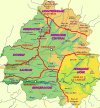
For this week, we’ll be taking a look at France, up until its current modern borders (which you’ll notice are quite different from the 1337 borders):
Countries:

When portraying the political situation of France in 1337, we had a few options. On one extreme, we could make it a ‘centralized monarchy’, like England or the Iberian ones, but with a much lower degree of control over its territories. Conversely, we could have a ‘French Crown’ IO, similar to the HRE. We decided to go with the middle term, which represents the French Crown lands with the country of France, and its networks of appanages and vassals as different subjects. We think that this way we can portray the progressive centralization of the crown under the reigns of Philip II, Louis IX, and Philip IV, while also portraying the powerful jurisdictional powers of the French feuds. We have two types of subjects in France, by the way: vassals, which represent the regular fief mouvants, and appanages, which were the feuds granted to members of the royal family, that could eventually revert to the French Crown.
You may also notice that there might be a problem incoming related to a couple of English possessions in the mainland, the County of Ponthieu, and, especially, the Duchy of Aquitaine, as well as the Channel Islands of Jersey and Guernsey which comprise a dangerously close non-core location of England (they aren’t big enough to be a worthwhile subject country, even if that might be a more accurate representation).
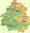
Locations:

An interesting distribution of locations. Some names may be a bit long, so, please blame the French, not us, and ask if you want to know which location it is.
Provinces:

We are aware that we have a severe inconsistency here, which is naming the provinces after locations instead of provincial and regional names (we were not very sure about what naming convention to use when we crafted this map). So we would be glad to receive feedback on the names that you think would fit. E.g.: Artois instead of Arras, Anjou instead of Angers, etc.
Terrain:


We’ll also read your feedback regarding the terrain of France, although we already know of some issues to correct (e.g.: changing the vegetation of the Landes to sparse instead of forests.
Cultures:

Although there are two big cultural divisions of the French cultures, Langue d’Oil and Langue d’Oc, we think that their regional subdivisions would make the situation more accurate for 1337, where there is a long way until the cultural unification of France.
Religions:

Not a very interesting situation, only 0.80% of the population is of a different religion (Judaism). We haven’t portrayed any Catholic heresy yet, maybe Cathars should still have some room in the Languedoc, as Montaillou, an Occitan Village from 1294 to 1324, points to? Also, while taking this screenshot, we improved the view of this map mode, making it more responsive to zoom levels.
Raw Goods:

The gold mines in the center of the map are going to die, as they were exploited only in recent times. Which other changes do you suggest?
Markets:

Paris already had replaced the fairs of Champagne as the main trading center of the region, driven by the growth of the crown lands and the royal power in the 13th century. Apart from that, we have the market at Bordeaux in Aquitaine.
Population:


Population, and also how it looks with colors when you have the country clicked (Paris, centralizing France since Hugh Capet…).
And that’s all for today! Next week we will move to the North-Eastern part of Europe, as we will take at look at Poland and the Baltic region. Cheers!
For this week, we’ll be taking a look at France, up until its current modern borders (which you’ll notice are quite different from the 1337 borders):
Countries:
When portraying the political situation of France in 1337, we had a few options. On one extreme, we could make it a ‘centralized monarchy’, like England or the Iberian ones, but with a much lower degree of control over its territories. Conversely, we could have a ‘French Crown’ IO, similar to the HRE. We decided to go with the middle term, which represents the French Crown lands with the country of France, and its networks of appanages and vassals as different subjects. We think that this way we can portray the progressive centralization of the crown under the reigns of Philip II, Louis IX, and Philip IV, while also portraying the powerful jurisdictional powers of the French feuds. We have two types of subjects in France, by the way: vassals, which represent the regular fief mouvants, and appanages, which were the feuds granted to members of the royal family, that could eventually revert to the French Crown.
You may also notice that there might be a problem incoming related to a couple of English possessions in the mainland, the County of Ponthieu, and, especially, the Duchy of Aquitaine, as well as the Channel Islands of Jersey and Guernsey which comprise a dangerously close non-core location of England (they aren’t big enough to be a worthwhile subject country, even if that might be a more accurate representation).
Locations:
An interesting distribution of locations. Some names may be a bit long, so, please blame the French, not us, and ask if you want to know which location it is.
Provinces:
We are aware that we have a severe inconsistency here, which is naming the provinces after locations instead of provincial and regional names (we were not very sure about what naming convention to use when we crafted this map). So we would be glad to receive feedback on the names that you think would fit. E.g.: Artois instead of Arras, Anjou instead of Angers, etc.
Terrain:
We’ll also read your feedback regarding the terrain of France, although we already know of some issues to correct (e.g.: changing the vegetation of the Landes to sparse instead of forests.
Cultures:
Although there are two big cultural divisions of the French cultures, Langue d’Oil and Langue d’Oc, we think that their regional subdivisions would make the situation more accurate for 1337, where there is a long way until the cultural unification of France.
Religions:
Not a very interesting situation, only 0.80% of the population is of a different religion (Judaism). We haven’t portrayed any Catholic heresy yet, maybe Cathars should still have some room in the Languedoc, as Montaillou, an Occitan Village from 1294 to 1324, points to? Also, while taking this screenshot, we improved the view of this map mode, making it more responsive to zoom levels.
Raw Goods:
The gold mines in the center of the map are going to die, as they were exploited only in recent times. Which other changes do you suggest?
Markets:
Paris already had replaced the fairs of Champagne as the main trading center of the region, driven by the growth of the crown lands and the royal power in the 13th century. Apart from that, we have the market at Bordeaux in Aquitaine.
Population:
Population, and also how it looks with colors when you have the country clicked (Paris, centralizing France since Hugh Capet…).
And that’s all for today! Next week we will move to the North-Eastern part of Europe, as we will take at look at Poland and the Baltic region. Cheers!