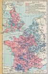
So in anticipation of the France review, I have finally finished the long suggestion list for it - warning, another extremely long post!
View attachment 1151947
Going counterclockwise from French Flanders and finishing in the centre, my proposals are:
Picardie, Artois & French Flanders
One of the wealthiest and most densely populated regions of France, then as now. The goal here is to represent some lordships, large cities, or natural regions that got left out, and better transition the province sizes between the currently much denser Flanders and Ille de France.
View attachment 1151839
1.
Montreuil (-sur-Mer)
Montreuil was a separate lordship and important port (the only port in the royal domain in the early Middle Ages, where it succeeded Quentovic) and had more than 10 000 inhabitants by the late Middle Ages, where the silting of its river port caused a decline. It did retain military importance however, as it was a great fortress built by Vauban. It was well known for its Cloth production, but for raw goods, only wheat seems to really fit (with corn and sugar eventually being brought from the New World)
Berck could possibly be split off from Abbeville, but I'm not sure the location would be large enough.
2.
Hesdin
One of the most important towns of Artois early in the period and the seat of its own region, Hesdin even survived being completely destroyed and rebuilt at its current location in 1553. Forested area, so Wood can fit as a tradegood. This also makes the independent lordship of Saint-Pol smaller and its shape resemble the historical one better.
3.
Bethune
Very important city throughout the period and a center of its own traditional region - the immediate area around the city had a population of 40-50 000 in 1300. The region is notable for Coal mining, which made it very important in the 19th and 20th centuries. If you don't add it as a location, it should probably replace Lens, which grew more important much later.
4.
Bapaume
A lordship and city on key trade crossroads, notable for its large fortress, the 'Key to Artois'. In 1330 it had passed back to the Count of Flanders, giving it a different owner compared to nearby locations in 1337. It was mostly known for the production of lace, similar to Cambrai, but for raw tradegoods, it seems to be Wheat or Sturdy Grains.
4.5
Therouanne
This one doesn't get a full number as I'm very torn on suggesting it. Therouanne was one of the most important cities of Artois and Flanders in the Middle Ages, and a diocese capital with the largest cathedral in France. You'd imagine the city would still be important today - and it likely would be, if it wasn't completely destroyed by Charles V in 1533. The region didn't remain destitute though - the town of Aire-sur-la-Lys is quite close, and it had a population of well over 4000 at the beginning of the game period.
I would also love to separate the lordship of
Guise from Calais, but I don't think there is space for that unfortunately
5.
Mauberge
To quote my proposal on the Low Countries:
"Same as with Mons, Valenciennes is large and the most natural splits are Avesnes and Mauberge to the east - and while Avesnes gave its name to the county (and thus the Avesnois region) and its powerful nobles and did have city rights and trade, Mauberge seems like the more important settlement (with a population of about 3000 in the 13th century already!), especially later in the period where it became a massive fortress. A famous Cheese producing area, Livestock fits."
Amiens and Saint-Quentin are absolutely huge compared to the locations surrounding them, and it's not like there is a lack of other notable towns and cities in Picardy - thus the three additions here, though it can be reduced to two if you feel it's too much. The borders I follow here are of the regions of Picardy
6.
Peronne
A massive fortress and religious center, Peronne played an important role in various wars throughout French history
7.
Montdidier
A very old city and county as well as a bailiwick seat.
Peronne and Montdidier are both part of the Santerre region, so they could be merged as a single location (Peronne). Santerre is a very fertile agricultural area, so Wheat or Legumes fit both locations.
8.
Doullens
Somewhat less important than the previous two, but the best option to split Amiens, a viscounty and an important military stronghold- when it was captured in 1595, 4000 people were massacred, implying a decent population. Alongside Amiens, Peronne, and Montdidier, it used to be one of the Aronndisements of the department as well and is still the center of North Picardy.
9.
Saint-Valery (sur-Somme)
Representing the Vimeu region southwest of Ponthieu that it is the capital of, Saint Valery was an important port - it is from here that William the Conqueror sailed to England. The location also includes Oisemont, the medieval capital of Vimeu and an important fortification during the HYW. The main economic activities were fishing and logging in the nearby Crecy forrest, so either Fish or Lumber fits as the tradegood.
Normandy
Normandy has a decent density already, but some of the location choices seem odd, and there are certainly notable possible additions
View attachment 1151845
A:
Dieppe over Arques
Dieppe was a very important port, one of the most notable French ports on the English Channel, and heavily fortified due to its military importance. Later it was also one of the major Huguenot centers. Despite its castle, Arques just seems far less important by this period, and as the locations seem too small for an addition here, I would replace it with Dieppe - though splitting it in two might just be possible. Dieppe is most well known for its scallops (but also other fishing in general), so Pearls or Fish fit the best as tradegoods (though the city was also well known for lace production)
B:
Harfleur over Tancreville
While this location is today obviously Le Havre, before it arose the biggest city and port in the area was Harfleur, which served as the chief port of all of Normandy and one of the main ports of France before its port silted up. It saw a famous siege in HYW, which eventually led to the battle of Agincourt. This location can also be split, with
Fecamp, a notable fishing port and fortified city taking its eastern parts
1.
Coutances
Definitely the only very glaring omission in Normandy, Coutances was the center of a bishopric and a traditional region, as well as the first seat of the Manche department. Well known for Apple production, so Fruit is the best tradegood, but the town's chief industry since the Renaissance has been book printing
2:
Honfleur
Honfleur was an important port city and a key port for French explorers of the New World, as well as a center of the slave trade. It had a population of ~10k in 1800. The only argument against Honfleur really is that it would split the already small Lisieux
C.
Eu over Aumale
Eu and Aumale were both important lordships, but if they cannot both be fit, then perhaps Eu is the slightly more important one? Certainly, it's the one I see represented more often, and the larger settlement. Was Aumale chosen due to being ruled by relatives of the kings of Castille?
3.
Verneuil
Harcourt and Pont-Audemer are both quite large and extend far to the south of their cities - I propose adding a southern location here, covering Verneuil and Breteuil. The region was a key battleground between the French and the English and ocassionally included in Perche rather than Normandy, and in 1337 might have been owned by Evreux (given the Voltairre's Nightmare mod border here, but I was unable to find proof myself). The region was known for its Iron ore and furnaces before the end of the 19th century, so Iron would be a great tradegood
4.
Mortagne au-Perche
Speaking of Perche, Alencon and Belleme are both rather large and the first one is oddly shaped, and includes a lot of land that is a part of Perche, unlike Alencon itself. Introducing Mortagne fixes this, and the town was a rival to Belleme for much of the period. The regional products seem to be black pudding and apples, so Livestock and Fruit fit as tradegoods.
D:
Nogent-le-Rotrou
Nogent-le-Rotrou was also one of the capitals of Perche, and should probably replace Alluyes, though both could theoretically fit if you want to keep Alluyes to represent Perche-Gouet (though even then, Brou might be the better location name) - the dotted line is there to represent what keeping both would look like. The region of Perche-Gouet was known for making cheesecloth, so Fiber Crops might be a good tradegood.
Sees was the seat of a bishopric, so it's also a possible addition to the north of Argentan.
Brittany
Brittany is still missing quite a few of its most prominent cities, though unfortunately its larger locations are more difficult to find worthy splits for than the smaller ones. Brest and Quimper certainly seem too large currently.
View attachment 1151861
1.
Saint Pol de Leon
The most obvious split of Brest, St Pol was the religious capital of Brittany and one of its wealthiest and most important cities until it's decline as a consequence of the French Revolution. It had over 2000 inhabitants in the 15th century and served as a major trade center and port as well. Today the city is best known for its artichokes (which became commonly cultivated in France in the 14th and 15th centuries), and is the center of the vegetable-growing Golden Belt of Brittany (including the famous Roscoff onions nearby), so Legumes (in a lack of better vegetable good) would be the best tradegood
2.
Morlaix
Morlaix is an awkward city to fit as it's right on the border between Tregor and Leon, but as it is closer to Tregor (and Tregor is more in need of a split), I represented it solely in the latter. An important port and cloth and goldsmith centre, the largest in Brittany, as well as the home to one of the oldest tobacco factories in France. The city had a population of over 10 000 during the French Revolution. Fiber Crops might be a good tradegood due to its local cloth and linen industry.
The rest of Tregor could also be split with the introduction of
Guingamp (an important county center and fortified town owned by the Penthievre lords) in its inland part, leaving Treguier (and later Lannion) to represent the eastern coast - represented by the dotted line here.
3.
Auray (Lorient)
Lorient is today one of the largest cities in Brittany and has been so since ~1700. The city was however only founded in 1664, and to avoid replacing the similarly important Vannes in a flavor event, I instead introduced a new location of Auray to its west. Auray was an important castle and town in its own right (with a large port at Saint-Goustan), the capital of the Land of Lanvaux. Lanvaux was primarily known for its woods, chopped town to build great fleets in Vannes and Lorient, so Lumber is the natural tradegood (I'd also change Vannes to Lumber as well), though Wheat and Fish were also produced.
4.
Carhaix
Brest currently goes further south than the land of Leon did, so Carhaix (today Carhaix-Plouguer) is introduced to fix that without making Quimper even larger (and taking some land from it as well). Situated at the location of an ancient Roman city, it is the capital of the inland Poher area, but I expanded it all the way to the coast around Chateulin and Crozon - this area could be redrawn to remain in the reduced Quimper instead. The area was known for its beef, so Livestock is the natural tradegood.
In 1337, Rohan was still the seat of the powerful Viscounts of Rohan. However, it lost this position to
Pontivy by 1418, which was almost certainly already larger at the start of the game. Haven't labeled this because there's an argument both ways, but Pontivy certainly becomes far more important soon into the game's timeline!
5.
Concarneau
Even with Carhaix added, Quimper remains large. This is remedied by adding Concarneu in its east. A decently important port (though not a large city, with a population of ~2000 during the Revolution), especially for tuna and sardine fishing (making Fish the obvious tradegood), this would also represent the Aven region of Cornouaille
The addition of Concarneau and Auray also allows the separation of ducal Breton domains from the land governed by local nobles in Quimper and Vannes, while St Pol represents the possessions of the powerful House of Rohan in Leon. Carhaix represents the possessions of Penthievre in Cornouaille, confiscated in 1420 by the Dukes of Brittany
6.
Fougeres
The most important city missing in inland and eastern Brittany, Fougeres was a major fortress involved in the wars in the area. What makes it especially important to represent is the fact that it was already owned by France in 1337 (since 1307), and only returned to Brittany in 1428. The city had many interesting industries, most notably Glass (making use of its local Sand deposits), Salt, Tin, and later shoemaking. To represent this, I'd give it either Sand or Tin. (In general, I would give Brittany at least one or two Tin-producing locations, as it's one of the oldest centers of tin mining in the world, much like the neighboring Cornwall!)
7.
Reze/Retz
Currently, the Nantes location extends south of the Loire and doesn't have sea access- both of these are clearly wrong. Extending the Loire estuary to reach Nantes is simple, and the reason is obvious - it was one of the biggest ports in France and Europe for much of the period! South of the Loire, the County of Retz was a clearly separate area from the rest of Brittany, and Nantes didn't extend south of the river until modern times, Reze was a big rival of it and the seat of the county. The location also includes the large fortress of Clisson to its southeast.
Adding a third location to Pays de Retz is also possible, either
Clisson (having Clisson represent the Vignoble region while Reze is shifted west) or
Pornic in the west.
Also, please, change the tradegood of Guerande to
Salt, its Salt deposits are world-famous.
8.
Ancenis
There is however another important addition I'd make to the region. Ancenis was a massive fortress that served to defend Nantes from the east, known as the Key to Brittany. It grew Wheat and Rye, so Wheat or Sturdy Grains are a good tradegood.
9.
Loudeac
Representing the inland parts of Pays Saint-Brieuc owned by the House of Rohan, it was renowned for its fairs and markets in the Middle Ages, and for its weaving industry throughout the period (making Fiber Crops a good tradegood).
10.
Lamballe
The current Saint Brieuc location can be split, with Lamballe taking its east. While this also creates somewhat smaller locations, I believe Lamballe is important to represent as the seat of the counts/dukes of Pentheivre. Economically, Lamballe is noted for a stud farm, but also produces grain, apples, seafood and leather - I'd say Horses are thus the best tradegood, but Fruit, Wheat and Leather are all possible.
Not sure which one I'd pick, but I'd change at least one location in Brittany to produce Fruit, to represent the famous Breton apple cider - Guingamp could be a good one for this if added.
11.
Palais/Paloe (Belle Ile)
Perhaps the shakiest location proposed here, Belle Ile seems to be just large enough to be an island province at 84km2. The island was a marquisate and was heavily fortified under Vauban. It was an important military outpost on the French Atlantic coast, most importantly in the Seven Years War where the British held it for two years before trading it for Menorca (but was also captured by the Dutch and Spanish through history as well). It had a relatively significant population of 6000 during the Revolution. As with many other islands, Fish (sardines especially) are the main tradegood, but sheep were also held on the island, with a famous local breed making Wool a possible tradegood as well.
This all allows for a restructuring in the provinces of Brittany as well, with Leon/Tregor being separated from Cornouaille and Saint-Brieuc being its own province as well (also including St. Malo). If two locations are added to Retz, even it could be its own province. Cornouaille does include Belle Ile, for historical reasons.
View attachment 1151879
Anjou & Maine
Much like Brittany, I find this region to be somewhat lacking compared to many other parts of France, thus it sees the largest number of additions
View attachment 1151880
I see you used the Senechaussees of Anjou in your map and that's great, but the borders weren't followed- if they were, the Angers one would be even larger and would lend itself to the natural splits- Cholet and Craon
1.
Cholet
The second largest city of Anjou and the capital of the Mauges region, it was an important feudal possesion as well. The city is best known for its textile industry.
2.
Craon
One of the two main cities of the northern Mayenne Angevine (together with Chateu Gontier) and the seat of the Craonais region and barony ("the first barony of Anjou") it was a huge fortress in the middle ages and an important merchant town
The town was known specifically for linen, making Fiber Crops a good tradegood, though the city also had Salt granaries and a well known breed of Craonnaise pig and cheese, making Livestock a good choice too.
3.
La Fleche
A full Senechaussee, I would split it off Bauge despite it creating somewhat awkward borders. It was also an important fortress and Jesuit centre, developing from the 17th century (with a population of 5200 in the beginning of the 18th century), also holding sway over many nearby towns (including Chateu Gontier). It is also the capital of the southern half of the Mayenne Angevine.The region grows wine and chicken, so Wine and Livestock are the best tradegoods.
The town of Beaufort (en Anjou) was also the seat of a Senechaussee, but it was rather small and it would be difficult to fit. Similarly, the southern part of current Loudun location was a part of the Saumur Senechaussee, with Richelieu (yes, the cardinal was from there), but it would be even more difficult to fit.
Maine is denser and less in need of additions, but Le Mans and Mayenne locations can use them
4.
Sable-sur-Sarthe
A strategically important castle, with a population of 1200 in the 15th century. Seat of the powerful de Sable family (including the famous Robert IV de Sable, Grand Master of the Templars), it saw the treaty that led to the union between Brittany and France. The region is very well known for its marble, so Marble is the obvious tradegood (one I'd give to Le Mans as well if Sable isn't added).
5.
Ernee
A castle built to protect against Breton incursions, Ernee grew into a large town, with a population of 4000 - 8000 in the 15th century, second largest and most important in Maine after Mayenne. The town is mostly known for leather and rope production, so Livestock or Fiber Crops could work as a tradegood
Poitou
The last of the western regions I feel were somewhat shorted, the main increase of locations here comes from splitting up Angouleme into multiple locations and increasing the density in Vendee, and somewhat in Poitou itself
View attachment 1151882
1.
Les Sables-d'Olonne (Olonne)
Separated from the town of Olonne in 1218, Les Sables grew into one of the most important ports in France, particularly for fishing, with 14 000 inhabitants in the 17th century. Replaced the previously important Talmont after its port silted up
2.
Challans (Commequiers)
The second addition in Vendee, Challans is the capital of the Breton Marshes. Early in the period, it was under the rule of the barony of Commequiers, centered at the eponymous castle, until becoming the administrative seat itself in the 17th century, having been an important trading center since the middle ages. The area is notable for Poultry farming of chicken and especially duck, Livestock is the best tradegood.
3.
Melle
Once an important town and galena mining center (galena is Lead with a lot of silver, both work as a tradegood, but Lead is perhaps rarer and is the dominant one in the ore too - but Silver was one actually used more, for minting), the mines remained important all the way until the 18th century.
4.
Lusignan
A walled town that was the home of the famous Lusignan dynasty of crusaders. The region was known for clover and wool production, making Fiber Crops and Wool the best tradegood options, though a lot of Wheat is grown here as well.
Between Melle and Lusignan, you could also choose only one location to add, I couldn't decide myself - regardless, the Silver/Lead of Melle should be the tradegood, with the other perhaps being given to another location in the province to represent both.
5.
Cognac
A fortified town that frequently changed hands in the HYW, Cognac was a rich trade center that even saw a diplomatic league formed in it. Of course, the town is most famous for the drink, making Wine the natural tradegood alongside a modifier.
6.
Ruffec
With Cognac separated, another split for Angouleme is required due to borders. Ruffec was a fortified seat of a barony, viscounty, and marquisate. The location would also include the fortified town and modern administrative center at Confolens.
7.
Saint-Jean-d'Angely
One of the most important cities of Saintonge, covering the northeastern parts of the province, it was large and wealthy for much of the period until it sided with the protestants in the French religious wars - it still had over 6000 people by the time of the Revolution. The region was famous for its wines, exported around Europe, so Wine is the natural tradegood.
It is mentioned that the Saint-Jean-d'Angely monastery owned large saltworks on the coast, so either Royan or La Rochelle should be changed to produce Salt
8.
Chauvigny
Currently, the location of Bellac spreads far into Poitou, while not including land to its north that's also a part of La Marche. This is fixed with its redraw and the addition of Chauvigny, a city which had five separate castles. The region is known for its stoneworks and quarries of lime, so Stone or Alum are the best tradegoods. The location also includes Lussac (les-Chateux), a cloth trading center
9.
Bressuire
Not as necessary as many locations suggested above, but Bressuire is the seat of its own natural region and the second most important possession of the viscounts of Thouars (who, along with Parthenay, should probably be represented on the map as vassals)
This all allows for the provinces to also be reshaped, with Poitou, Vendee, Angouleme and Saintonge (with Aunis) all having proper historical borders
View attachment 1151883
Aquitaine
Here covering the wide area of southern France, I feel like this region was done quite well, especially compared to the lower populations it has near the Pyrenees, so there are comparably fewer suggestions.
View attachment 1151897
1.
Blaye
The seat of a county and natural region, Blaye was an important fortress in the HYW and later being another one of Vauban's forts, known as the Key to Gironde. Well known for Wine production, which brought wealth to its port. It had a population of ~5k during the Revolution.
I also tried fitting
Castillon here due to its battle, but I'm not sure it's necessary and it's very close to Libourne
2.
Sarlat (la-Caneda)
Bergerac is very large, especially if the borders of Perigueux are made more accurate. To alleviate this, Sarlat is added to its east, representing the Perigord Noir region. Sarlat was a major city and religious center throughout most of the period, with 5000 inhabitants in the 13th century. The region grows foie gras, truffles, figs, and nuts, so I'd represent that with a Fruit tradegood.
The west of Bergerac and Perigueux could both be split further, by adding
Mussidan and
Riberac respectively.
3.
La Reole/Marmande
I cannot currently read the name of the location between Libourne, Bordeaux, Bergerac, and Agen, but there should be two locations here, with the second taking from the western parts of Agen - La Reole in the current location, and Marmande in the east.
4.
Cadillac (sur-Garonne, though the suffix was only added a year ago)
Covering the southern parts of the current Bordeaux location Cadillac was a fortified town important for its defenses. Today it's obviously best known for the car, but it was generally a Wine-producing region.
Most of the historical lordships in the region are represented, with the exception of Tursan, Fezensac, and two small lordships near Navarre, thus...
5.
Aire-sur-l'Adour(Tursan)
Much of Tursan was ruled by the Miremont family as vassals of Foix-Bearn. This location would also fix the rather awkward shape of Mont de Marsan (here I redrew the area further to better match the borders of historical counties). Aire-sur-l'Adour was the largest city and a bishopric centre, as well as a stop on the pilgrimage to Santiago de Compostella. Tursan is a famous wine-producing region, so Wine is the obvious tradegood
6.
Vic-Fezensac
Auch and Mirande are both rather large, and Fezensac is not represented, so this is a natural inclusion. The county was a part of Armagnac. An agricultural region, Wine and Wheat were grown and sheep were herded, so any of them work.
7.
Bidache / Saint-Palais
The small seigneuries of Agramont and Amikuze-Ostbarret cover the aforementioned three regions of Lower Navarre, but by 1337 they were integrated into Navarre proper. However, between 1570 and 1793, the region was home to the Principality of Bidache (vassals of Navarre since 1329 and de facto independent already in 1434), an independent state that served as a haven for fugitives from France (including also a large Jewish community). Bidache was the capital of Agramont, and the capital of Amikuze-Ostbarret was Saint-Palais, which was the larger settlement, which even had city and mint privileges. Both cities are in the Ossau-Iraty sheep cheesemaking region and sheep herding has been the primary economic activity since the Middle Ages., so I'd say Wool is the best tradegood.
Languedoc
Same as above, there are some additions here, however not too many (though there are cities I'd love to add, like Sete, which are just impractical)
View attachment 1151926
1.
Apcher (Saint-Chely-d'Apcher)
Mende is rather large, and the impassable terrain allows for interesting geography here. The castle of Apcher was the centre of a barony and marquisate covering the north of Gevaudan and the Aubrac plain (the Margeride massiff) The castle declined in importance with time and was replaced by Saint-Chely-d'Apcher, today one of the most important cities in the department. Apcher was an iron mining region, so Iron is the obvious tradegood.
A further/alternative split for Mende is
Florac, another barony and administrative center, as well as a Silk growing region.
A:
Anduze over Ales
This one is simple: Ales seems to be misplaced. It definitely warrants inclusion in its proper place, but here it's replaced by Anduze, a very important lordship and city (with over 7000 people at its medieval peak) and the center of French sericulture (making Silk the obvious tradegood), as well as Zinc mining and later Protestantism.
2.
Ales
As per above, just shifted to its correct location
3.
Espalion
Rodez and Millau are both large, so a new location is introduced to break them up somewhat. Espalion was a decently important town, with the large castle of Calmont d'Olt. The region is especially known for horse breeding, so Horses are the natural tradegood.
4.
Rieux
Splitting off the south of Toulouse, Rieux was the center of a bishopric and a free city since 1202. Also including Carbonne, this is a mostly agricultural, Wheat growing region.
There is a split of Limoux possible with either
Rennes-le-Chataeu or
Termes, both castles on the border with Iberia and with Catalan minorities, but the region has extremely low population. Similarly,
Durfort near Castelnaudry was famous for its Copper production but seems too small.
5.
Gaillac
West of Albi (another rather large location), Gaillac was a major religious and winemaking center, as well as a center of woad (dye) production. Nicknamed the Rose of the South, it is the third most important city of Tarn today, it had a population of about 6000 during the Revolution. As mentioned, Wine or Dyes would be the best tradegood, as common in the region.
6.
Vabres (l'Abbaye)
Covering the south of the large Millau, Vabres was the center of a bishopric and had a large abbey. The location also includes other towns, such as Camares and Saint-Affrique (a fortified town that was the largest settlement subject to Vabres, with 3500 people during the Revolution). Vabres and Saint-Affrique are mostly agricultural, goat and sheep-breeding regions, but Camares is known for its Copper and Lead mines, so I would go with one of those (Copper probably, as Lead is more present in the immediate environment), though Wool or Livestock are also possible
I considered placing Minerve over Saint-Pons, as the first gave its name to the region, however, Saint-Pons was the center of a diocese and likely much larger than Minerve, with respective populations of 4500 and 250 during the Revolution.
Provence
Given how dense Italy is, and the transitional role Provence plays between it and France, I think additions are warranted here, especially as some rather important cities are missing.
View attachment 1151930
To start with, both Frejus and Toulon extend far inland when their natural and administrative regions were far more coastal - this is fixed by adding Draguignan and Brignoles to cover their respective regions
1.
Draguignan
Important city and the capital of Var until quite recently. Had a population of 3500 in 1300 and 10 000 in ~1650, being the fourth most important city in Provence. The region is noted for Olive and Grape cultivation, so either Olives or Wine works as the tradegood, though it also produced Wheat, silk, paper, and soap.
2.
Brignoles
The summer residence of the counts of Provence and the first seat of the Provencal parliament. Brignoles has been famous for its plums since the Middle Ages, so Fruit is the best tradegood. This location can be further split, with Barjols or St. Maximin added.
3.
Carpentras
With Orange being redrawn to better match the borders of the lordship, space is opened up for the addition of Carpentras, the second most important town of the Papal possessions in Provence and the capital of Comtat Venaissin. It was a decently large city too- in the Middle Ages its weekly market had over 200 traders, implying a population well in the high thousands, as well as a home to one of France's oldest and most significant Jewish communities. The city is famous for its truffles, so I guess Spices fit?
The depiction of Nice could also be improved, particularly of its inland
4.
Tende
Tende was not owned by Provence like the rest of Nice at this point, instead the mountain fortress (here representing the pass between Nice and Cuneo), but eas a separate county ruled by the Lascaris-Ventimiglia family (yes, Lascaris like the Byzantine emperors). This would make Tende an incredibly interesting tag to start with and try to reclaim the Byzantine throne! Notably, Tende only became a part of France after WW2, and has its own dialect of Ligurian. Tende has an old crystal mine, so Gems could be an interesting tradegood, but it also has sheep and cow keeping and cheesemaking, so more common tradegoods like Livestock and Wool also make sense.
5.
Puget-Theniers
Covering the rest of inland Nice, Puget was the capital of the Var valley. For much of the period, it was ruled by the barony of Beuil, ruled by a branch of the famous Grimaldi family. Also includes Vence, a bishopric centre. Primarily an agricultural and logging area, so Lumber would work well as the tradegood.
I would have also suggested
Monaco, but it was already shot down in the Italy thread. I would like to note that Monaco was larger than now, including Menton and Rocquebrune, but it would still be difficult to fit.
6.
Martigues
Aix, despite being on the Rhone, didn't really serve as a major port, and this is a very populous area. I thus created a location for Etang de Berre Lagoon, with Martigues as the capital. Martigues was an important trading port that even rivaled Marseille and had its own viscounty (which also included other cities like Istres), until Marseille definitively became the main French Mediterranean city under Louis XIV - Martigues still remained important, with about 7000 inhabitants, 7th most in Provence. This area produces mostly Wine and Fruit, but Wine definitely seems like the more important tradegood here.
7.
Manosque
Digne is quite large, so I would add Manosque to split off its southern parts. Manosque is a large city (larger than Digne today), with a population of 10 000 in the 13th century (with a later decline to ~5k). Famous wine-growing region, Wine is the natural tradegood.
8.
Apt
An important administrative and religious center. Produces wine, honey, truffles, olive oil, wheat, and Fruit, with Fruit seeming like the most important one due to its famous candied fruits, exported since the 14th century - but Wheat also works as a tradegood due to its well-known local variety. Later an important centre of Waldensias, as well as Jews.
9.
Tarascon
Administrative center with a large fortress, Tarascon splits the large Arles location. It was a large settlement too, with 9000 inhabitants during the Revolution. Famous for its Olive Oil, so Olives are the obvious tradegood
If the medieval administrative divisions of Provence are followed, there are even more possible additions, such as
Luc, St. Maximin, Moustiers, Hyeres, Barjols etc., but I'm not proposing them here - though certainly a few can be fit. If added,
Hyeres should produce Salt - otherwise, Toulon should be given Salt as a tradegood.
I'm not sure how exactly to represent the famous Provence lavender? Medicaments? If so, I'd change one or two of the locations in the area to it!
Dauphine
Covering the lands between Provence and Burgundy, I have a lot of suggestions here as many of its most important cities are missing, and many locations are massive
View attachment 1151931
1.
Montelimar
A lordship of the powerful Adhemar family, Montelimar was disputed between Provence and Dauphine, even passing to papal possession multiple times (as it was co-owned in 1337, it could accurately be given to them at the start). This also helps break down the odd shape and large size of Valence. It had about 5000 inhabitants in the 18th century, and was a major protestant centre during the French religious wars. Montelimar is most famous for its nougat, which I'd represent as Fruit.
2.
Nyons
Gap is rather large, and Nyons was an important city, particularly between the 13th and 16th centuries. Nyons is famed for its Olives, making them a natural tradegood.
3.
Embrun
Embrun was the center of an archbishopric and a fortified town (another one of Vauban's forts), and a temporary capital of Protestant rebels. The local economy is based on sheep and apples, so I'd give it Fruit as the famous Sisteron lamb is already represented in two locations to its south.
4.
Villard-de-Lans
A bit of an odd suggestion as it's not the most important city, but it splits the large Die and represents the Vercors Massif, thus giving it mountainous terrain. Vercors had significant autonomy during the Ancien Regime due to its remoteness. Villard de Lans is famous for its cattle breed, so Livestock is the natural tradegood, but Lumber is also possible as it is noted in the area since 17th century. The location can also be Sassenage, an important barony which owned the Vercors (but the city is also very close to Grenoble)
5.
Annonay
Annonay is an important city (the biggest in the department today, with about 3500 inhabitants in 1500 and 7000 in 1793), a major pilgrimage stop on the way to Puy en Velay, and a trade center with city rights. It was one of the most important centers of Protestantism in France. The city was well known for its tanneries and paper makers, but neither represent a raw tradegood - perhaps Livestock for the tanneries? Regardless, for the raw tradegood I'd represent the nearby vineyards with Wine.
6.
St. Laurent du Lac (Le Bourg d'Oisans)
Grenoble is absolutely massive and stretches far to the south of the city's traditional regions. This is easily fixed by adding Saint Laurent du Lac (today called Le Bourg d'Oisans), representing the Oisans region. The region had significant autonomy (much like Escartons to its south), and St. Laurent was a lordship and a fortified town. Oisans was a mining region, of Copper and Iron (and to a lesser extent Gold and Silver), as well as Coal, Stone, Galena (lead), and crystals. Genuinely difficult to choose just one from so many!
7.
Conflans (Albertville)
Moutiers is currently very oddly shaped, combining the thin Alpine valley with more open lands to its northwest. I would fix that by adding the province of Conflans, a medieval fortified town that guards the entrance to the Tarentaise and county center. Later, the town was expanded and became Albertville, famous for hosting the Winter Olympics. The region was well known for Iron mining and later steel works as well, so Iron works as a tradegood, as does Livestock, representing the famous cheese of the nearby Beaufort-sur-Doron (which can also be its own location, taking from Faucigny)
Furthermore, the east of the Tarentaise Valley could be split as
Bourg St. Maurice.
8.
Privas
A walled town that was also one of the centers of Protestantism in France, and the capital of Ardeche. It's famous for its chestnut production, so Fruits are the best tradegood, through Iron mines and silk mills also existed
9.
Voiron
Vienne is very large, and its eastern parts were at times contested with Savoy, until they were exchanged in 1355 for Gex and Faucigny in the Treaty of Paris (NOTE! Evian and Faucigny should belong to/be in personal union with Viennois, while Gex is under Geneve in 1337). This is represented by the new Voiron location, an important manufacturing town, with 5000 people during the Revolution, as well as the birthplace of the Carthusian order. Voiron produced mostly hemp, so Fiber Crops are a good tradegood (though it later produced Silk as well)
The area can be further split by adding
Maubec, an important barony and Savoyard vassal
10.
Chateau de Clermont
To bring Belley more in line with nearby locations Chateau de Clermont is created from its north. An important castle and town in the Middle Ages and the seat of a castellany, it was the summer capital of the Counts of Geneva (and would thus belong to them rather than Savoy)
Auvergne & Limousin
Awkward to fit into any other region, Auvergne and Limousin get their own section for the few locations I would suggest here.
View attachment 1151933
1.
Carlat
While it might be difficult to fit with Aurillac, Carlat was a strong castle and an important viscounty separate from Auvergne, and the centre of the Carlades region. Carlades is well known for the Laguiolle cheese, so Livestock is a good tradegood.
2.
Issoire
Added to break up Brioude and Thiers, Issoire suffered a lot during the French Religious Wars, but had a population of 5000 during the Revolution. A mostly agricultural and woodcutting region, Lumber seems like a good tradegood..
3.
Aigueperse (Montpensier)
As Riom is also large and oddly shaped, it's north is split off as Aigueperse, the capital of the lordship, county and duchy of Montpensier, owned by many lords outside of Auvergne, including Dreux at the start and later Berry. The city itself had a population of over 4000 during the Revolution. The location also includes the fortress of Chaptuzat. Aigueperse is known for pralines and marzipan, so Fruit is the best tradegood.
4.
Brive (le-Gallarde)
Limousin is somewhat of a mess in this period, and many possible additions exist based on its lordships - Combron, Pairac, Bridiers, etc, but I'm not sure how many could feasibly be added. One that definitely seems necessary is Brive, the largest city of Correze. A possession of the powerful barons of Malemort and played a role in the HYW - though the city only truly surpassed Tulle in modern times, it did have a population of 6000 during the Revolution.
Burgundy (&Franche-Comte)
Most of the important cities are already represented, this is suggesting the remaining ones alongside splitting some of the larger locations
View attachment 1151934
Salins should, as the name implies, produce
Salt.
1.
Jussey
Vesoul is very large, so I would split off its northwestern part as Jussey, a fortified town important for the Franco-Spanish wars in the region. Also includes the river port of Corre. The region is known for viticulture, so Wine is the best tradegood.
2.
Lure
By fixing the borders of Montbeliard to the historical ones and reducing the size of Luxeuil (which really should be its own tag as an abbey), space is created to add Lure, an independent city within Burgundy, with an abbot that was a HRE prince and whose protection was disputed with Lorraine. There is notable Sand extraction in Lure, so that would be a good tradegood.
The very large Semur and Dijon location (as well as the still large neighbors) allow for additions in Burgundy itself
3.
Beaune
Large and important walled town (with over 10 000 inhabitants during the Revolution), famous mostly for being the capital of Burgundian viticulture (thus making Wine the natural tradegood)
4.
Avallon (&Vezellay)
Avallon was the administrative centre of west Burgundy (the Avalois region) and a major fortified town. Avallon is noted for its biscuit and gingerbread production, so Wheat might be a good tradegood, but the heavily forested area also makes Lumber one too- the town is known to have traded in Wine, Lumber and Livestock all. The location also includes Vezelay, which is famous for its abbey, a major pilgrimage center that played an important role in starting the Second and Third Crusades, and the area around is famous for its wines - if space allows it, I'd add Vezelay as a separate location as well (represented by the dashed line here)
5.
Auxonne
Covering the fortress of eastern Burgundy (after being acquired from Franche Comte in exchange from Salins centuries before), another one of Vauban's fortresses later on. Auxonne is noted for vegetable production (especially of onions), so I'd give it Legumes as the tradegood.
The area around Macon and Chalon includes numerous locations worth including, such as
Cluny, Lons-Le Saunier and
Louhans, but I'm not sure if this area should have a density so much higher than the rest of Burgundy
Lorraine
Lorraine was an incredibly messy region I feel you approximated mostly well, but could be redrawn to be more accurate and thus also allow for the addition of a few major cities and two lordships
View attachment 1151937
Epinal is currently too large to represent the Bishopric of Metz exclave - its reduction in size, alongside the redrawing of Mirecourt, Nancy, Toul, and Sarrebourg allows for several new additions, notably
1. Luneville
The city of Luneville wasn't very important at the game start, but it was a tradepost on the salt trade routes and an occasional residence of the dukes of Lorraine, but it came to be the capital of Lorraine in ~1700 and a large city, with a population of 11 700 during the Revolution. Luneville is well known for its earthenware and embroidery, so Clay or Fiber Crops make the most sense for the raw tradegood
2.
Charmes (Vaudemont)
Vaudemont was the fortified seat of the County of Vaudemont, a separate county only united into Lorraine in 1473, however, Charmes was the larger settlement so I'd use it as the name of the location owned by Vaudemont. Local industries in include woodcutting, dairy farming, and legume farming, so I'd give it Legumes or Lumber.
3.
Blamont/Blankenberg
Blamont was a relatively large lordship just to the west of Salm, which was eventually acquired by the House of Salm as well (separately from nearby Upper Salm since 1246) before changing hands multiple times, eventually uniting with Lorraine in 1506, over a century before the rest of Salm domains. The area was primarily agricultural and dairy-producing, so I'd give it Livestock.
4.
Remiremont
To further buff the actual Duchy of Lorraine, Remiremont is added from southern parts of St. Die and Epinal. "The Beauty of the Vosges" was an important trading and religious center, particularly notable for its powerful abbey, which shared the rule of the city with the Dukes of Lorraine. The industries include Fruit growing, Horse breeding, Sheep, Cow and Goat breeding, and Forestry. I would give it either Fruit or Horses (as they're not very present in the region), but Lumber, Wool, and Livestock are all also possible.
5.
Dieuze
With Saint-Avold moved to actually border Saarbrucken ( at the expense of Bitche), space is created to represent further possessions of Lorraine in the area (and to compensate for the loss of Bitche, which really should be its own tag). Dieuze was famous for two very different mines - Salt and Coal (the latter starting from the late 18th century), both of which would make a good tradegood, but I'd probably give it Salt given its larger importance during the period itself
Commercy would be a great inclusion from the western parts of Toul, a powerful lordship (under Saarbrucken by 1337), and a large town, but it seems like it would be too small.
Alsace
While this can also be viewed as a part of Germany in the period, I'm putting my suggestions under France. Alsace is probably the region in France most in need of improvements compared to the current map, with its HRE status in mind
View attachment 1151939
1.
Mulhouse
I do not get some of the choices in Alsace, most notably the exclusion of two of its 3 most important cities, Mulhouse and Colmar. Mulhouse was a Free City, Decapole/Zehnstadtebund and even a member of the Swiss Confederation for centuries (being the last city in Alsace to be taken by France) due to its staunch Calvinism. Mulhouse was also one of the centres of the industrial revolution in France, but it's cloth and leather manufacture far predates it. The most notable raw resource today are the potash mines (Alum most likely), but they were only exploited starting from early 20th century, so unless you choose to represent them early, the best tradegood is Wine, representing the local vineyards. If added, Apiculture also fits as it is notable in the city's environment.
Replacing Ferrette with Altkirch is an option, as the later was the capital of Sundgau, but at this point Ferrette was just recently an independent lordship, so there is an argument to keep it - I would probably replace the Ferrette location with Altkirch, but give it, Ensisheim and Belfort cotes of the Ferrette/Pfirt tag.
2.
Colmar
Colmar was another important Free City and Decapole member, and the second largest city in Alsace for most of the period (with over 6000 people in the Middle Ages). Colmar is the capital of the Alsatian wine region, so Wine is the obvious tradegood choice, but it's also well known for its jams, making Fruit an option too, since Wine is common in the area.
3.
Munster-en-Alsace (Murbach)
This location is basically the merger of two different states - the free city of Munster, and the abbey of Murbach. Munster was another Decapole member, though it had a religious history of being owned by an abbey as well - it had about 3000 inhabitants during the Revolution. Murbach was one of the most powerful abbeys of the empire (alongside Fulda and Kempten, which I expect to see represented, and Wissembourg which is in the northeast corner of Alsace we can't see, and was largely replaced by the free city with time), once owning lands as far off as Lucerne itself and retaining great wealth and power even when transfered to France. Thus, I would name the location Munster, but have the owner be the Abbey of Murbach. The location should produce Livestock, as it's the home of the famous Munster cheese, whose producion dates back to at least the 15th century, though Lumber was also an important part of the economy of Munster, while the monks of Murbach owned large Iron mines nearby.
4.
Selestat (Rappoltstein)
Another one of the important Free Cities and Decapole members, the third and fourth largest in the region after Strasbourg and Colmar (and ocassionally Haguenau) with a population between 5000 and 6000 in the middle ages and 7000 during the Revolution, Selestat was also an important religious and humanist centre. It was a key battlefield in the 30 years war and an important fortification after being taken by France. The location is also meant to represent the lordship of Rappoltstein, centered on Rappoltsweiler, which ruled much of central Alsace, and can be the tag owning the location. It was a river port, mostly for Wine, but also for hay, fish, cereals, Iron and salt. The city also has a Bread museum, implying wheat was an important part of the economy, so Wheat can be the tradegood, though many options are possible, most notably Wine once Rappoltsweiler/Ribeauville is also taken into account.
5.
Rosheim
Another Free City and Decapole member, I would however give this location to Strasbourg to further represent the powerful Prince-Bishopric which owned most of the land around it, as Rosheim was the smallest of the Decapole cities (still had a population of over 3000 during the Revolution). The area is mostly known for viticulture, so Wine is the natural tradegood here as well.
6.
Wissembourg (Lichtenberg)
Representing the many lordships od northern Alsace, most notably Lichtenberg and Fleckenstein, the aforementioned free city of Wissembourg is used as the location name, with the owner being the Lichtenberg/Hanau tag, also owning land in Germany. The area is noted for viticulture (of course) and logging, and since Lumber production was mentioned for several Alsace locations without being given to any, I would give this location Lumber.
Depending on the location sizes, it's also possible to use Wissembourg to represent itself and
Fleckenstein, while
Lichtenberg being a separate location.
Champagne
As a part of redrawing Lorraine, I also redrew the lands around Bar, which allows for representation of certain exclaves or important cities.
View attachment 1151943
1.
Saint Dizier
The largest city of Haute Marne today, Saint Dizier started as a fortified town in the 13th century before becoming an important fortress defending France from the east, with a population of 5500 during the Revolution. The city is well known for its historic metallurgy, so I'd give it Iron as a tradegood.
2.
Vouziers
Making Grandpre smaller and closer to its historic lordship borders and making Clermont better match the historical area ruled by Bar, Vouziers lies on the border between Champagne and the Ardennes, Vouziers was an important grain market with numerous mills, so I'd give it the Wheat tradegood.
3.
Stenay
With Verdun's borders being changed to better fit the historical borders of the bishopric, it opens space for Stenay, a historic exclave of Bar (earlier owned by Bouillon and Verdun), later turned into a fortress by Vauban. Seems to be a mostly agricultural area, Wheat fits as a tradegood.
4.
Briey
A former county and later an important possesion of Bar and a fortress of France, Briey seems important enough to separate from Longwy, especially with the land gained by fixing the Metz location borders. The Briey basin is one of the most most important sources of Iron in the world, as is represented in nearby locations already, so Iron is the natural tradegood.
5.
Ligny (en-Barrois)
The shifts allow for a split of the Bar-le-Duc location, allowing for the introduction of Ligny. Ligny was home to powerful counts, nominally vassals to Bar but who often conducted their own diplomacy and were members of the great Luxembourg family. The counts of Ligny played an important role in the HYW, including being the ones to capture Joan of Arc. The location also includes Gondrecourt (le-Chateau), another important division of Barrois. It is a very wooded area, so perhaps Lumber fits best as the tradegood.
There is an argument to include Apremont (la-Foret) over St. Mihiel, as Apremont was the seat of the county, however Apremont was a small village and Saint Mihiel was a large town housing the Barrois mint
Centre
Covering the leftover regions in central France, this mostly deals with splitting some rather large locations, though many of the cities added were important in their own right as well.
View attachment 1151944
Bourbon and especially Moulins are very large, so Bourbonnais can definitely see additions. First, Montlucon is pushed to the north, allowing for the addition of Evaux
1.
Evaux (les-Bains)
The capital of Combraille, Evaux is known for its roman baths which got restored in the 17th century. Also includes other towns like Auzances and Chambon-sur-Voueize (the early medieval capital). Combraille is a mostly Livestock raising region, making it the natural tradegood.
2.
Cusset/Vichy
Covering Limagne Bourbonnaise and Montagne Bourbonnaise, this splits up Moulins. Cusset and Vichy were both royal towns, Cusset with an important fort and Vichy with its famous baths. While Vichy is of course much more famous and larger today, but Cusset was larger at the time, with about 4000 inhabitants during the Revolution. The region is home to Saint-Pourcain wines, well known since the middle ages, so I'd give it Wine as the tradegood.
3.
Corbeil
I understand keeping Paris together and i.e., not splitting Versailles (though in UK we've seen Westminster split, so
Versailles might have an argument too), it's odd to see it have such a massive location. I figured at least the south could be split, as the location of Corbeil. Corbeil was a decently important town, a fortified county centre and river port supplying Paris, seeing two French treaties (including the Auld Alliance) signed there, as well as a royal wedding. The city was the centre of flour milling, so Wheat is probably the best tradegood, but vineyards are also mentioned since the early Middle Ages
Fontainebleu was another very important royal castle, which could be fit between Melun and Nemours.
Blois, Bourges & Issoudun, Orleans and Nevers are all rather large, so I've suggested splits for them
4.
Cheverny
Splitting Blois and representing a part of the Sologne region, Cheverny is the home to one of the most famous Loire Valley Chateaus. The location also includes Romorantin(-Lanthenay), the capital od Sologne. Built as a planned city, with a palace designed by Da Vinci, Francois I'sts mother Louise of Savoy intended to construct a new royal capital here. As with much of the Loire valley, it was best known for its wines, and is indeed home to the Cheverny Wine region, making that the natural tradegood.
5.
Vierzon
Splitting the massive Bourges, Vierzon was a fortified city and seigneuirie centre that was the logistical centre of Joan of Arc's armies during her campaign in the Loire Valley. Vierzon is noted for having fine clay which later allowed a porcelain industry to form, so Clay seems like the best tradegood.
6.
Salbris
Capital of the eastern Sologne and powerful barony and Marquisate, the location also includes the castle of La Ferte-Imbault and splits the southern half of Orleans. The region is known as the hunting capital of France, so Wild Game is the obvious and rather unique tradegood.
7.
Decize
A fortified town once on an island in the Loire, Decize splits the Nevers location. It is best known by far for its Coal mines, already exploited since at least 1488 (and likely before the 13th century as well!), making them some of the oldest in the world and making Coal the obvious tradegood
The tradegood of Paris being Legumes is odd - not only because current rules for food tradegoods make it useless in a city. The most obvious tradegood for me is
Stone - the underground of Paris was basically a huge quarry for millenia, with much of the city being built from its own Stone!


.png "image (15).png")


.png)


.png)
.jpg)