• We have updated our Community Code of Conduct. Please read through the new rules for the forum that are an integral part of Paradox Interactive’s User Agreement.

Tinto Maps #30 - 20th of December 2024 - South America

Hello and welcome to one Friday of map-loving! Today is special, as our 30th Tinto Maps, devoted to South America, is the last regular one. This implies that it won’t be the last, though - we plan to have two Tinto Maps Extra on December 27th and January 3rd, and then we will continue with the Tinto Maps Feedback posts as we progress with the map review.

But don’t worry, as on the first post-Christmas Friday, January 10th, I will start a new series, Tinto Flavor, in which we will show the content that we have been working on for Project Caesar. And I promise you, it’s a ton of content, so you will have to play the game in due time to discover it all…

Before we continue, one note: as we're covering a lot of lands today, don't be shy and ask for more detailed maps of the type you want wherever you want them, and I'll try to provide in the replies. And now, let’s start with the South American maps:

Countries
Countries1.png

Countries2.png

Countries3.png

Most of the countries that can be considered being at a State-wise level in 1337 are mostly concentrated in what is today Perú. We have famous ones, as the Chimu or Chincha, and you may also see a tiny country, Qusqu, which would later become the Inca Empire, the long-term goal while playing in the region.

Dynasties
Dynasties1.png

Dynasties2.png


SoPs
Sops1.png

Sops2.png

Sops3.png

Sops4.png

Sops5.png

There are SoPs spread out all across the continent, making for a really interesting mix in the Peruvian area (again). We're already thinking about how to better visualize the coexistence of these two types of countries in the political layer, but it's going to take us some more time to get there.

Locations
Locations1.png

Locations2.png

Locations3.png

Locations4.png

Locations5.png

One note: I'll talk a bit more in-depth about the design of the Brazilian locations if you scroll down, in the Terrain section.

Provinces
Provinces1.png

Provinces2.png

Provinces3.png


Areas
Areas1.png

Areas2.png


Terrain
Climate.png

Topography.png

Vegetation.png

There are huge geographical variations in South America, being one of the most diverse continents. One of the things I wanted to discuss is that we've tried to portray the Mata Atlântica, the original forest cover that was present in Brazil before the Portuguese colonized it, and a different type of land exploitation started. In this regard, we've been reading the feedback of the Brazilian community, and I want to say that our intention here is to portray the most realistic situation for 1337. That said, we've already internally discussed that we may reduce its scope, so it doesn't look so extreme, but we'd like to hear your opinions about it. And here you have one of the images that we used as a reference for it, so you get a good grasp of our intention:
Mata Atlantica.png

Development
Development.png


Natural Harbors
Harbors1.png

Harbors2.png


Culture
Cultures1.png

Cultures2.png

Cultures3.png

Cultures4.png

Cultures5.png

Cultures6.png

The jewel of the crown in this region. We've tried to portray the Pre-Columbian cultural diversity of these lands as accurately as possible, and, well, here you have the results.

Languages
Languages1.png

Languages2.png

Languages3.png

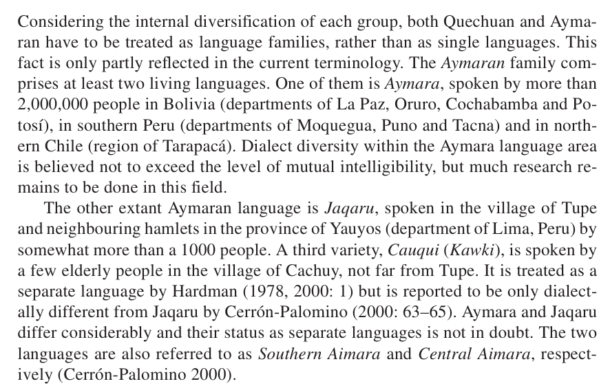
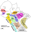
And the languages that group these cultures.

Religions
Religions1.png

Religions2.png

Religions3.png

We've tried to do our best to group the cultural religions of South America into different groups, based on common believes, gods, rituals, etc. Let us know what do you think of them. Oh, also, the Inti religion has its own differentiate mechanics, which we'll explain in the future!

Raw Goods
Raw Materials1.png

Raw Materials2.png

Raw Materials3.png

Raw Materials4.png

Lots of different natural resources in South America. You may note that some are more common compared to other regions (such as Medicaments). We've also been tweaking the color of different resources, with the help of your feedback!

Markets
Markets.png

The green market is centered around Teyuna, and the red one is Chinchay.

Population
Some issues with the map of the region this week (sadly), so let's discuss the numbers. The total in the continent is 10.22M, divided this way:
  • 1.66M in Colombia
  • 1.2M in Brazil
  • 5.07M in Andes
  • 877K in Chaco
  • 1.4M in La Plata
And that's all for today! We hope that you enjoyed the Tinto Maps series! We've definitely done, and it's also greatly helping us to make Project Caesar a much better game, with your help and feedback. Cheers!
 
  • 135Like
  • 57Love
  • 31
  • 9
  • 6
Reactions:
No changes on the Amazon Basin is certainly one of the choices... I hope this is not the final state of the map in the region. Hoping they add a couple settled countries, like the Marajoara and Kuikuro.
I would not take anything as settled at least until we get the feedback post for the regions, and even then, some tweaks might be made before release.
 
  • 3Like
  • 3
Reactions:
I would not take anything as settled at least until we get the feedback post for the regions, and even then, some tweaks might be made before release.
To be honest, I don't think it will be good at the end of the day.
It seems do me that information regarding Amazon basin settlements was mostly ignored (I say this because I have seem little to no interaction from the dev team regarding suggestion on the area, even though they interacted with most other sugestions).
I have been wrong before, but I got low hopes for this.
 
  • 2
  • 1Like
Reactions:
To be honest, I don't think it will be good at the end of the day.
It seems do me that information regarding Amazon basin settlements was mostly ignored (I say this because I have seem little to no interaction from the dev team regarding suggestion on the area, even though they interacted with most other sugestions).
I have been wrong before, but I got low hopes for this.
I wouldn't be in a hurry to make that assumption. The devs have said that they're spending a lot of time on Brazil in particular and look how long it took for feedback on the British Isles! They have also said they're strongly considering changes in Oceania and none of those have been visible yet, I'd remain optimistic!
 
  • 2Like
  • 1
  • 1
Reactions:
With Europa Universalis V finally announced, I realized I never gave my feedback on the South America map. I know it may be too late for any changes, but I still wanted to explain myself just in case changes could be brought in about the map.

I will mostly deal with Chile and broader southern cone (I am an economic historian of early republican/late colonial Chile), but I do have some general comment on the continent. I get that North America is a bigger continent in landmass, and its geography is seen generally more hospitable, and thus I understand the more province detail. However, I think in South America there still a lack of province density.

From a South American perspective, I would love to play in a sort of "what could have been" of South America and create a development there that never was in real life. The contrast with North America play a big role in that imagination, of a succesful North against an unsuccesful South. Now, for the timeframe that is not so much a reality that would be much clearer later, but having the option to develop the land and build would be nice. That would need provinces to be able to represent the region accordingly, bringing imigrants, assimilating or creating new cultures and the like. I fear that with more colonization possibilty happening in North America, the South America experience will remain a secondary area, which in the period it wasnt so much. It may even be the only period in history in which the region actually had global impact due to potosi mining.

This means that my main issue with Chile and the Argentinean side is the lack of provinces, and some geographic details. The argentinean issue is mainly too big provinces which if the country would have gone into a more development intensive path probably would not be the case today. Increasing density their would allow much more entertaining gameplay options as there would be opportunities for disputes and development.

Now, Chile. Chile was IRL a semiperiphery of the Spanish Empire, colonized in the mid sixteenth century, with frontier colonization restarting in the eighteenth century after the population crisis of the 16 and 17 centuries. By the moment of Independence in 1820, the population in Chile was roughly the same as the whole Argentinean side (the colonized parts). In this regard Chile was relatively a more prominent colonization are of the South Cone, and would like to see a better representation.

First, regarding terrain, which is the most important aspect in my opinion. Chile is not flatlands on the coast and then the rising andes. Chile is a sandwiched between the Coastal mountain range and the Andes, from west to east it should be represented imo as two provinces, hills on the coast, flatland in the middle and TI in the andes.
a) Tarapaca region: I think its well represented. Though plateau could be more fitting than flatland as the land rises quite steeply from the coast before plateauing into the andes.
b) Atacama: Same with Tarapaca.
c) Elki: Province quantity is alright, here we don't see the sandwich yet, but most of the cities are in river valleys. This land should definitely be hills as there is no intermediate depression (fertile flatlands where most of Chileans live in)
d) Pikunmapu: Here you need to split provinces. Rangkawe, Kolchawe, Kuruko, Mawlen, should have a different hill province in the coast (1. Rapel, 2. Bucalemu, 3. Vichuquen, 4. Constitucion/Nueva Bilbao). The coast was left undeveloped by natives but colonization of the coast happened after Spanish colonization. Also Quilic Ura should not be a natural harbour. Valparaiso is decent, but Chile have better ones in Talcachuano and San Antonio. Valparaiso developed due to political/institutional reasons not so much due to geographic factors (a lot of investment had to be made to make it good, like land reclamation and such). Callao is a better harbour for example.
View attachment 1293850
e) Butalmapu: The land division here I find weird. Laftkenmapu and pehuenmapu are fine, the other three I doubt. The native division seems informed with a native perspective and not from a land colonization one. Historically the province was colonized in the nineteenth century from north and south. Here is my proposal based not in the Mapuche historical butalmapus but on the colonization of the area that happened slowly from the eighteenth to the conquest of the nineteenth. 1. Lafkenmapu (Flat), 2. Angol (Hills), 3. Carahue (Flat), 4. Temuko (Flat). 5. Pehuenmapu (Mountains).
View attachment 1293820
f) Willimapu: This region lacks provinces and omits the colonization that happened in early nineteenth century and the disputed lands between Huilliches and colonials. Here is my proposal: 1. Valdivia (Hills), 2. Villarica (Flat), 3. La Union (Flat), 4. Osorno (Flat), 5. Carelmapu (Hills). 6.Llanquihue (Flat). Also, the three Chiloe provinces should be hills.
View attachment 1293827
g) The southernmost provinces seem fine from my perspective. I appreciate the terra incognita in Aysen and Magallanes, those places are very hard to occupy.

The last issue is a more thorny one. You decided to put all the Puelmapu as mapuche culture in the game:
View attachment 1293832

However, I think this is mistaken, especially for the 14th century. The mapuche had not yet moved to that area, as it was done once they had horses through Spanish contact. The argentinean side was occupied by other native peoples more related with the Tehuelche (Aonikenk). The lands were scarcely populated in any case, at least the pampas (non andine, atlantic) side.

This last point is political, as the Puelmapu is claimed nowadays by mapuche militant groups. The Neuquen (lower Andean) area may have been inhabited by pehuenches (mapuche-related), but the pampas most likely werent, and were incorporated into the mapuche linguistic cultural world during the 16 and 17 centuries. I would suggest you revise and group Gününa Küne (het) and Gününa Yajich with the Teush (Tehuelche). Thus, putting the Mapuche cultural frontier in the Pehuenmapu province and leaving the pampas provinces for the Broader Tehuelche culture.

In any case, the history of the native peoples of Argentina is severely underdeveloped and I understand that borders of groups that were scarce in numbers and nomadic in organization is hard to come by.

I guess these were all my observations, please do ask if you need clarification of justification around some aspects, I am happy to discuss these items.
 
Last edited:
  • 6Like
Reactions:
Paradox, while as an Uruguayan I really appreciate the effort put into the South American map, and the fact that the Charrua were introduced as a tag in EU4 (albeit with the wrong flag), I do have to say that you made a mistake with their location in 1337. When the Spanish arrived in the XVI century. the Charrua lived mainly between the Paraná and Uruguay rivers, so in the Argentine Mesopotamia, not in Uruguay. The Spanish colonization of Santa Fe was the event which pushed them westerwards, and that would result in the Charruas assimilating the other tribes of the area into their "Charrua nation".

With a start date in the XIV century, the Charrua should be almost entirely in the Argentine Mesopotamia, as the Litoral is dominated by other tribes (like the Bohanes and the Yaros) who appear to be related to the kaingang. Some authors also relate the Charrua with the kaingang, but taking into account their Pampean origin and other factors I believe the hypothesis presented by the authors that relate them with the Mataco-Guaicuru languages. But in any case, the point is that the "Charrua" should be in Mesopotamia by 1337. I know that Uruguay doesn't warrant the level of detail to add representation of the other groups, but I just think that the starting situation should be as historical as possible.

In another topic, it is there a reason for why the borders of Uruguay, not just the locations, but the provinces, don't use the Uruguay river as the border? If I am guessing correctly you are using the justification that the Uruguayan interior was governed from Buenos Aires, and not Montevideo, in the XVIII century as a reason. But to speak honestly, it looks ugly and it makes me sad that we can't have the proper borders for the Oriental Province because the Chana location is on both sides of the Uruguay river.

1747361590816.png


The Spanish considered the Banda Oriental as a single unit, so I think it would be better if the borders between La Plata and Guenoa respected the Uruguay river. Like there is no reason to want to have Colonia in the same province as Buenos Aires but not have Montevideo there, Buenos Aires and Montevideo were sister cities in which vecinos of one were registered as vecinos of the other, like if the existence of the complejo portuario rioplatense was used as the justification for the current borders it doesn't make sence to have Montevideo as separate.

1747361750301.png
 
  • 7
  • 2
Reactions:
Are Andean natives going to have some kind of special modifier for living in the mountains? There is genetic evidence of them being adapted to their environment. https://en.wikipedia.org/wiki/High-altitude_adaptation_in_humans
Not just them, Tibetans have a similar mutation, and if memory serves Ethiopians as well. That would be a neat... Advance? For these nations.
But there's also developmental adaptation (see barrel chest) and behavioral adaptations.
 
Are Andean natives going to have some kind of special modifier for living in the mountains? There is genetic evidence of them being adapted to their environment. https://en.wikipedia.org/wiki/High-altitude_adaptation_in_humans
I'm not sure how this would work mechanically, those regions will virtually never interact in game so an overarching modifier seem to not do much.
Also how would this work with mixed populations? The Colombian end of the Andes today are majority European admixed I believe, or at least 50/50.
 
  • 1Like
Reactions:
Paradox, while as an Uruguayan I really appreciate the effort put into the South American map, and the fact that the Charrua were introduced as a tag in EU4 (albeit with the wrong flag), I do have to say that you made a mistake with their location in 1337. When the Spanish arrived in the XVI century. the Charrua lived mainly between the Paraná and Uruguay rivers, so in the Argentine Mesopotamia, not in Uruguay. The Spanish colonization of Santa Fe was the event which pushed them westerwards, and that would result in the Charruas assimilating the other tribes of the area into their "Charrua nation".

With a start date in the XIV century, the Charrua should be almost entirely in the Argentine Mesopotamia, as the Litoral is dominated by other tribes (like the Bohanes and the Yaros) who appear to be related to the kaingang. Some authors also relate the Charrua with the kaingang, but taking into account their Pampean origin and other factors I believe the hypothesis presented by the authors that relate them with the Mataco-Guaicuru languages. But in any case, the point is that the "Charrua" should be in Mesopotamia by 1337. I know that Uruguay doesn't warrant the level of detail to add representation of the other groups, but I just think that the starting situation should be as historical as possible.
I still have a lot of reading to do on the natives, but from what I understood the Charruas were present in the region of today Uruguay. One source also just says they lived in both margins of the Uruguay river, so it's somewhat compatible with your claim. Other source place them in the Montevideo region....
If you have some sources about them, I would love to add them to my list of readings.

I also noted on other comment that it is really weird to portrait the Charruas and not the other peoples of the Pampas. They seemed to be similar and the only reason that the Charrua name is more remembered is because of the "Charrua nation", which is a much more modern notion. At least in all the sources I read, they never use the name Charrua to all the tribes in the Pampas. The Charruas were one specific people and there were others such as the Bohanes(I read under the name mboanes), Iaros, Minuanos, Guenoas and Chanás. There are some interlink between the tribes, but I wasn't to conclude if they could be portrait as one culture and SOP or should be many cultures and SOP. I believe that currently the Charrua SOP is supposed to be an umbrella term for all the Pampas peoples, but I strongly believe that in this case the name Charrua is not adequate as it erases the other tribes.


In another topic, it is there a reason for why the borders of Uruguay, not just the locations, but the provinces, don't use the Uruguay river as the border? If I am guessing correctly you are using the justification that the Uruguayan interior was governed from Buenos Aires, and not Montevideo, in the XVIII century as a reason. But to speak honestly, it looks ugly and it makes me sad that we can't have the proper borders for the Oriental Province because the Chana location is on both sides of the Uruguay river.
Agreed. The Uruguay and Paraguay rivers are major geographical frontiers and in a region were most borders were vague at best, I believe this should count for something.
The Spanish considered the Banda Oriental as a single unit, so I think it would be better if the borders between La Plata and Guenoa respected the Uruguay river.
Again agreed. And historically, the Banda Oriental was a single entity in terms of colonization. It shares the emptiness of government and the lack of interest to colonize it. For a long time, basically it was an "empty" buffer region between the Buenos Aires spanish region and the São Vicente portuguese region.
 
With Europa Universalis V finally announced, I realized I never gave my feedback on the South America map. I know it may be too late for any changes, but I still wanted to explain myself just in case changes could be brought in about the map.

I will mostly deal with Chile and broader southern cone (I am an economic historian of early republican/late colonial Chile), but I do have some general comment on the continent. I get that North America is a bigger continent in landmass, and its geography is seen generally more hospitable, and thus I understand the more province detail. However, I think in South America there still a lack of province density.

From a South American perspective, I would love to play in a sort of "what could have been" of South America and create a development there that never was in real life. The contrast with North America play a big role in that imagination, of a succesful North against an unsuccesful South. Now, for the timeframe that is not so much a reality that would be much clearer later, but having the option to develop the land and build would be nice. That would need provinces to be able to represent the region accordingly, bringing imigrants, assimilating or creating new cultures and the like. I fear that with more colonization possibilty happening in North America, the South America experience will remain a secondary area, which in the period it wasnt so much. It may even be the only period in history in which the region actually had global impact due to potosi mining.

This means that my main issue with Chile and the Argentinean side is the lack of provinces, and some geographic details. The argentinean issue is mainly too big provinces which if the country would have gone into a more development intensive path probably would not be the case today. Increasing density their would allow much more entertaining gameplay options as there would be opportunities for disputes and development.

Now, Chile. Chile was IRL a semiperiphery of the Spanish Empire, colonized in the mid sixteenth century, with frontier colonization restarting in the eighteenth century after the population crisis of the 16 and 17 centuries. By the moment of Independence in 1820, the population in Chile was roughly the same as the whole Argentinean side (the colonized parts). In this regard Chile was relatively a more prominent colonization are of the South Cone, and would like to see a better representation.

First, regarding terrain, which is the most important aspect in my opinion. Chile is not flatlands on the coast and then the rising andes. Chile is a sandwiched between the Coastal mountain range and the Andes, from west to east it should be represented imo as two provinces, hills on the coast, flatland in the middle and TI in the andes.
a) Tarapaca region: I think its well represented. Though plateau could be more fitting than flatland as the land rises quite steeply from the coast before plateauing into the andes.
b) Atacama: Same with Tarapaca.
c) Elki: Province quantity is alright, here we don't see the sandwich yet, but most of the cities are in river valleys. This land should definitely be hills as there is no intermediate depression (fertile flatlands where most of Chileans live in)
d) Pikunmapu: Here you need to split provinces. Rangkawe, Kolchawe, Kuruko, Mawlen, should have a different hill province in the coast (1. Rapel, 2. Bucalemu, 3. Vichuquen, 4. Constitucion/Nueva Bilbao). The coast was left undeveloped by natives but colonization of the coast happened after Spanish colonization. Also Quilic Ura should not be a natural harbour. Valparaiso is decent, but Chile have better ones in Talcachuano and San Antonio. Valparaiso developed due to political/institutional reasons not so much due to geographic factors (a lot of investment had to be made to make it good, like land reclamation and such). Callao is a better harbour for example.
View attachment 1293850
e) Butalmapu: The land division here I find weird. Laftkenmapu and pehuenmapu are fine, the other three I doubt. The native division seems informed with a native perspective and not from a land colonization one. Historically the province was colonized in the nineteenth century from north and south. Here is my proposal based not in the Mapuche historical butalmapus but on the colonization of the area that happened slowly from the eighteenth to the conquest of the nineteenth. 1. Lafkenmapu (Flat), 2. Angol (Hills), 3. Carahue (Flat), 4. Temuko (Flat). 5. Pehuenmapu (Mountains).
View attachment 1293820
f) Willimapu: This region lacks provinces and omits the colonization that happened in early nineteenth century and the disputed lands between Huilliches and colonials. Here is my proposal: 1. Valdivia (Hills), 2. Villarica (Flat), 3. La Union (Flat), 4. Osorno (Flat), 5. Carelmapu (Hills). 6.Llanquihue (Flat). Also, the three Chiloe provinces should be hills.
View attachment 1293827
g) The southernmost provinces seem fine from my perspective. I appreciate the terra incognita in Aysen and Magallanes, those places are very hard to occupy.

The last issue is a more thorny one. You decided to put all the Puelmapu as mapuche culture in the game:
View attachment 1293832

However, I think this is mistaken, especially for the 14th century. The mapuche had not yet moved to that area, as it was done once they had horses through Spanish contact. The argentinean side was occupied by other native peoples more related with the Tehuelche (Aonikenk). The lands were scarcely populated in any case, at least the pampas (non andine, atlantic) side.

This last point is political, as the Puelmapu is claimed nowadays by mapuche militant groups. The Neuquen (lower Andean) area may have been inhabited by pehuenches (mapuche-related), but the pampas most likely werent, and were incorporated into the mapuche linguistic cultural world during the 16 and 17 centuries. I would suggest you revise and group Gününa Küne (het) and Gününa Yajich with the Teush (Tehuelche). Thus, putting the Mapuche cultural frontier in the Pehuenmapu province and leaving the pampas provinces for the Broader Tehuelche culture.

In any case, the history of the native peoples of Argentina is severely underdeveloped and I understand that borders of groups that were scarce in numbers and nomadic in organization is hard to come by.

I guess these were all my observations, please do ask if you need clarification of justification around some aspects, I am happy to discuss these items.
nice work!!!
 
I still have a lot of reading to do on the natives, but from what I understood the Charruas were present in the region of today Uruguay. One source also just says they lived in both margins of the Uruguay river, so it's somewhat compatible with your claim. Other source place them in the Montevideo region....
If you have some sources about them, I would love to add them to my list of readings.

I also noted on other comment that it is really weird to portrait the Charruas and not the other peoples of the Pampas. They seemed to be similar and the only reason that the Charrua name is more remembered is because of the "Charrua nation", which is a much more modern notion. At least in all the sources I read, they never use the name Charrua to all the tribes in the Pampas. The Charruas were one specific people and there were others such as the Bohanes(I read under the name mboanes), Iaros, Minuanos, Guenoas and Chanás. There are some interlink between the tribes, but I wasn't to conclude if they could be portrait as one culture and SOP or should be many cultures and SOP. I believe that currently the Charrua SOP is supposed to be an umbrella term for all the Pampas peoples, but I strongly believe that in this case the name Charrua is not adequate as it erases the other tribes.


Agreed. The Uruguay and Paraguay rivers are major geographical frontiers and in a region were most borders were vague at best, I believe this should count for something.

Again agreed. And historically, the Banda Oriental was a single entity in terms of colonization. It shares the emptiness of government and the lack of interest to colonize it. For a long time, basically it was an "empty" buffer region between the Buenos Aires spanish region and the São Vicente portuguese region.
The Charrua eventually lived in the Montevideo region, according to the Spanish themselves they exterminated the yaros and bohanes in wars of conquests. The Charrua nation was created by them assimilating the other groups that existed in the Banda Oriental. The issue, as I mentioned, is their location by 1337. Before the Spanish colonization of Santa Fe they mainly lived between the Paraná and Uruguay rivers. And yeah, they crossing the Uruguay river sometimes happened, but their centre was in Mesopotamia, not Uruguay.

For sources you can consult the work of Renzo Pi Hugarte Los Indios del Uruguay or Daniel Vidart El mundo de los charrúas
 
  • 3Like
Reactions:
I noticed that the map updates are very advanced, so they will soon (or already) be implemented in South America, so, even though it is incomplete, I decided to post the current state of my feedback, as I improve it I will update this post instead of making a new one, so as not to make life difficult for @Aldaron.

View attachment 1264867

And the same map without names:

View attachment 1264868

Overall, I removed some of the anachronistic locations and redesigned the impassable terrain.

As before, the source for the edges is the evolution of the Brazilian municipal network, according to the IBGE, perhaps there are even shapefiles. The names of the municipalities, as the IBGE does not present, were found on the TSE website by simply searching for the name of the state with the year of a census (1872, 1900, 1911, 1933 or 1950). The names of the localities are those of the oldest locality to be founded or emancipated, according to the availability of historical data. History, dates and names for the localities can be found on the IBGE Cidades. Although I am making a list, just search for any Brazilian city, on my map or not, by its current name to find the data in "history and photos". Note that Rondônia and the north of Mato Grosso are not included, this is because I am researching native peoples and I want to do something within the territorial configuration pertinent to them, since Brazilian colonization is, in general, very recent in this area. I also used the TRI map from @Sulphurologist, and the vegetation map of Brazil (more specifically in this download) before colonization. In these two links you can access PDF and shapefiles. Some borders, however, follow geographic landmarks, whose source is HydroSheds . The shapes of the provinces and areas are the result of groupings based on the history and geography of the regions, such as the factual divisions of the hereditary captaincies of the 1500s (straight lines were in practice ignored and the official boundaries of what they became (the current states) were only defined later), the first counties and the sections separated by powerful rivers and hydrographic basins. The Amazon (this is an area with dense and impassable forest) had provinces shaped up to the last point of navigable rivers, generally the ascent is impeded by waterfalls or rapids as in the Tapajós, Madeira or Xingú, or the last point where there was a colonial settlement, in the Juruá and Negro. The stars indicate the capitals, but I did not do a study.

View attachment 1261224

Here is the incomplete result of the distribution map of native peoples. I used as sources the Nimuendaju map, the work of Loukotka map, a map of a study published in the journal Confins and the maps available on the internet from The native languages of South America. In addition, written sources from IBGE Cidades, Wikipedia and ISA that is a indigenous NGO. Some other studies that map indigenous archaeological sites were also taken into account.

View attachment 1261214

Suggestion for vegetation, where dark green indicates jungle, medium green forest, light green wood, orange grassland (actually I would say something between this and wood) and beige grassland as well (or something between this and sparce).

View attachment 1264869

I know it's not necessary, but I did it to analyze the representation of the terrain on my map.

View attachment 1264872

View attachment 1264873

At many points this becomes a design decision, so these settings are not imperative when transitioning between locations.

1- PARAÍBA (= BAD RIVER)

Map namePortuguese nameTupi nameOther nameNote
NatalNatalPotĩ'îy
(= shrimp river)
Nieuw Amsterdam (dut)From the name of the river that runs through the city and gives its name to the current state of which it is the capital, that is, the Potengi River.
São José de MipibuSão José de Mipibu--Mipibu is reported to have originated from Mopebu, which was the name of a native village.
Vila FlorVila FlorKangûeretama
(Kangûer-etama = land of skeletons bones)
-Name of the second oldest city in the location, Canguaretama.
Nova CruzSão BentoTare'ir'y
(= river of traira (fish species))
-
TourosTouros--
AngicosAngicos--
MossoróMossoróMosorok
( Mo-sorok = which makes tear)
-Mossoró is certainly a Tupi word, by which they called a Cariri tribe. The etymology is uncertain.
AssúAssúTabûasu
(Taba-ûasu = big village)
-
ApodiApodiPotĩ'y
(= shrimp river)
-Although a valid etymology cannot be found, the sequence Poty, Pody and Apodi in the municipality's coat of arms leads me to this conclusion.
Pau dos FerrosPau dos FerrosKamará (= plant species)-From the name of the second oldest city in the location, São Migueld o Camará, which in turn takes its name from the mountain range that separates the Rio Grande from Ceará.
CaicóVila Nova do PríncipeKaîkó
(Kaîa-kó = wildfire)
-
AcariAcariGûakary (= fish species)
Santana do MatosSantana do Matos--
PiancóSanto Antônio do Piancó--
SousaSousa--
PombalPombal--
PatosPatos--
São João do CaririSão João do Cariri--
MonteiroAlagoa do MonteiroPiripiri (= plant species)-Name given to the lagoon that gave rise to the city.
CuitéCuitéKuîeté
(Kuîa-eté = legitimate gourd)
-
AreiaBrejo d'Areia--
Campina Grande---
IngáVila do ImperadorIngá (= legume species)
PilarPilar--
MamanguapeMamanguapeMamangákûape
(Mamangá-kûa-pe = in the mamangás (species of shrub) cove)
In word construction, you can omit the "a" at the end of the stem, in this case it would generate "gk", I don't know if it is right or if I should also omit the "g" or "k". or if it was part of the portugueseization
João PessoaParaíbaParaíba
(Pará-aíba = bad river)
Frederikstad (dut)
Fernando de NoronhaSão João--Uninhabited at the start of the game.

2 - PERNAMBUCO (PARANÃPUKA = SEA CRACK)

Map namePortuguese nameTupi nameOther nameNote
RecifeRecife-Maritzstad
(dut)
OlindaOlinda--
IgarassuIgarassúYgarusu
(Ygara-usu = large canoe, that is, boat.)
-It could be called Itamaracá (Itamaraká (Itá-maraká = stone rattle) as well.
IpojucaNossa Senhora do Ó de Ipojuca'Yapoîuka
('Y-apó-îuka = river of rotten roots)
-
Bom JardimBom Jardim--
Vitória de Santo AntãoVitória de Santo Antão--
Água PretaÁgua Preta--
CaruaruCaruaruKarûara'y
(= river of wizards)
-
Brejo da Madre de DeusBrejo da Madre de Deus-
Porto CalvoBom Sucesso--
AtalaiaAtalaia--
MaceióMaceió--Apointed to come from Masaió, as a Tupi name.
Marechal DeodoroMadalena--
Palmeira dos ÍndiosPalmeira dos Índios--
PenedoPenedo-Maritzstad
(dut)
The same Dutch name as Recife, could be Boulder Maritzstad to distinguish them, literally Maritzstad from the rock.
TraipúPorto da FolhaTare'ipu
(Tare'ira-pu = sound of traira (fish species))
-
Mata GrandeMata Grande--
CimbresCimbres--
São Bento do UnaSão BentoY'una
(= black river)
-
BuiqueVila Nova do Buíque-
GaranhunsGaranhunsAguaránhũ
(Aguará-nhũ = field of maned wolf)
-
TacaratuTacaratu--
FlorestaFloresta--
FloresFlores de Ribeira de PajeúPaîé'y
(= river of shamans)
-
Afogados da IngazeiraIngazeira--Ingazeira comes from Ingá, which gives its name to another location in Paraíba.
Serra TalhadaVila Bela--
SalgueiroSalgueiro--
CabrobóCabrobó--Certainly a native name, about which sources differ.
ExuExuEîxu
(= species of wasp)
-
Santa Maria da Boa VistaBoa Vista--

3 - CEARÁ
(Originally, SIARÁ, obscure etymology.)

Map namePortuguese nameTupi nameOther nameNote
FortalezaFortalezaMukur'ype
(Mukury'y-pe = in the mucuri (species of plant) river)
-The Mucuripe point corresponds to the fortified area that gave the city its name.
CanindéSão Francisco das Chagas do CanindéKanindé
(= bird species)
-
BaturitéVila Real Monte-MorYbytyreté
(Ybytyra-eté = real mountain)
-
CaucaiaVila Nova de SoureKa'akaîa
(Ka'a-kaÎa = burned forest)
-
ItapipocaVila ImperatrizItapirpoka
(Itá-pira-poka = burst skin stone)
-
CascavelCascavel--
AracatiSanta Cruz de Aracati'Arakatu
('Ara-katu = good wind)
-
RussasSão Bernardo de Russas--
Limoeiro do NorteLimoeiro--
JagauribeJaguaribeÎagûar'ype
(Îagûara-'y-pe = in the river of jaguar)
-
MombaçaNossa Senhora da Glória de Mombaça--Although some point out that it comes from Mombasa (a type of plant), it is more likely that it comes from the African city of the same name that was part of Portugal.
QuixeramobimQuixeramobim--Probably Kiriri name.
QuixadáQuixadá--Probably Kiriri name.
AcaraúAcaracuAkará'y
(= in the river of carás (root species))
-
SobralSobral--
GranjaGranjaKuruá'y
(=river of a rodent species)
-
Santa QuitériaSanta Quitéria--
IpuVila Nova Del Rei'Ypu
(= river of noise)
-
TauáSão João do Príncipe de InhumunsTagûá
(= Soil variety)
-
JucásSão MateusAîuraká
(= plant species)
Jucás refers to the name given to the tribe in the region, which in turn comes from a species of tree with the same name in colonial Tupi, corrupted from the original word in ancient Tupi.
Icó---Etymology uncertain, if from Tupi should to be = 'Ykó which means riverside farm.
Assaré---
Lavras da MangabeiraSão Vicente Ferrer de Lavras de Mangabeira--
CratoCrato--

4 - TOCANTINS (TUKÂNTĨ = TOUCAN BEAK)

Map namePortuguese nameTupi nameOther nameNote
TocantinópolisBoa Vista do TocantinsTukântĩ
(Tukâna-tĩ =toucan beak)
-It is the name of the river, which was given in reference to its shape at the mouth, which this location has.
AraguacemaSanta Maria do Araguaia--Araguaia is a Tupi name, which has more than one place, when I have listed them all, I will see which one is better positioned.
Pedro AfonsoSão João--
Porto NacionalPorto Imperial--
NatividadeNatividade--
ParanãParanãParanã
(Pará-nã = looks like sea, big river)
-
ArraiasNossa Senhora dos Remédios de Arraias--
PosseNossa Senhora Santana da Posse--
NiquelândiaSão José do TocantiinsY'akuba
(= hot river)
-
FormosaArraial de Couros--
UruaçuSantanaUrûasu
(Uru-ûasu = big urus (bird species))
-
Santa Rita de CássiaSanta Rita do Rio Preto--
CotegipeCampo LargoAkuti'ype
(Akuti-y-pe = in the river of agoutis)
-
BarraBarra do Rio Grande--
Pilão ArcadoPilão Arcado--
RemansoRemanso--
BarreirasBarreiras--
CorrentinaRio das Éguas--
CarinhanhaCarinhanhaÛakaryaîa
(Ûakary-aîa = Acari (fish species) jagged)
-
Santa Maria da VitóriaSanta Maria da Vitória--
GurupiGurupiKurub'y
(Kurubá'y = River of pebbles)
-

5 - GOIÁS

Map namePorrtuguese nameTupi nameOther nameNote
MineirosMineiros--
JataíParaísoÎate'i
(= bee species)
-
Rio VerdeRio Verde--
CaiapôniaTorres do Rio Bonito--
UberabaSanto Antônio de Uberaba'Yberaba
(= shining river)
-
PrataCarmo de Morrinhos--
Monte Alegre de MinasMonte Alegre--Called Toribaté for a while. Without research, I would guess it means real joy.
Estrela do SulDiamantino da Bagagem--
Palmeiras de GoásSão Sebastião do Alemão--Literally from German, perhaps it would be reasonable to replace it with das Palmeiras, since we do not know if there would be German immigration in a Portuguese colony.
GoiásBoa Vista de Goiás--
PirenópolisMeia Ponte--
Pilar de GoiásPilar--History has shown that there used to be a village called Papuã, if it was Tupi;
Papu'ã
(= Really round)
MorrinhosVila Bela do Parnaíba--Parnaíba is a Tupi name, which occurs at various points, as the developers said that distant locations may have the same name, it is not a problem, but there are three locatios further south with the same name and this one is more appropriate.
CatalãoCatalão--Name from a people from the western Mediterranean.
Santa Cruz de GoiásSanta Cruz--
LuziâniaSanta Luzia--
FormosaVila Formosa da Imperatriz--

6 - SÃO PAULO

Map namePortuguese nameTupi nameOther nameNote
São PauloSão PauloPiratininga
(Pirá-tininga = dried fish)
-
Santo AmaroSanto AmaroÎara'ybátyba
(Îara'yba-tyba = palm grove (of the Jerivá species))
-Name of the river that bathed (today displaced to the west) the center of the municipality (today part of São Paulo)
Mogi das CruzesSantana de Mogi das CruzesMoî'y
(Moîa'y = River of Snakes)
-
São RoqueSão RoqueKarumbé'y-Name of the river that cuts through the city. Probably means river of the vessel.
Santa IsabelSanta IsabelAruîa
(Aru-Îa = Frogs galore)
-Tupi name of another city in the location.
Santana de ParnaíbaParnaíbaParanaíba
(Paranã-aíba = Bad river)
-
AtibaiaSão João Batista de AtibaiaAtybaîa-
Bragança PaulistaBragançaÎaguar'y
(= River of the Jaguars)
-
JacareíJacareíÎakare'y
(= River of the Alligators)
-
TaubatéSão Francisco das Chagas TaubatéItáybaté
(= Tall stones)
-
PindamonhangabaNossa Senhora do Bom Sucesso de PindamonhangabaPindamonhangaba
(Pindá-monhanga-aba = place of make fishhook)
-
ParaibunaSanto Antônio da ParaibunaParaibuna
(Pará-aíba-una = Bad black river)
-
CunhaNossa Senhora da Conceição de CunhaIndaîá-Name of a species of palm tree that names the neighboring mountain range of the city.
LorenaNossa Senhora da Piedade--According to Wikipedia, the Puri called the region Ipacaré and the Tupi Guapacaré.
JundiaíJundiaíÎundi'a'y
(= River of Jundiás (fish species)
-
ItuItuYtu
(= waterfall)
-
CampinasSão Carlos--
Porto FelizNossa Senhora da Penha de AraritaguabaAraritá'uaba
(Arara-itá-'u-aba = Place for macaws to eat stone)
-
PiracicabaVila Nova da ConstituiçãoPirasykaba
(= place where the fish arrive)
-
LimeiraNossa Senhora das Dores de TatuibiTatuyby
(= land of armadillo)
-
Mogi-MirimMogi-MirimMboî'y Mirĩ
(= small river of snakes)
-
São João da Boa VistaSão João da Boa Vista--
São SebastiãoSão SebastiãoIperu'y (= river of sharks)-There was so much options to this place Tupi name's this one is the oldest.
São VicenteSão Vicente'Ypanema
(= bad luck river)
-Based on the chronicles of Hans Staden.
ItanhaémNossa Senhora da Conceição de ItanhaémItanha'ẽ
(=stone vessel)
-
IguapeNossa Senhora das Neves de Iguape'Ykûape
(= in the river cove)
-
EldoradoXiriricaXiri'rika-
CananéiaSão João de CananéiaYbypeba
(= smooth earth)
-
SorocabaSorocabaSorokaba
(=dug place)
-
ItapetiningaItapetiningaItapetininga
(Itá-pé-tininga = dry stone path)
-Or = Itapebatininga
ItapevaItapeva da FaxinaItapeba
(= smooth stone)
-
BotucatuSant'Anna de BotucatuYbytyrakatu
(= good mountain)
-
ItaporangaSão João BatistaItaporanga
(= beautiful stone)
-Anachronistic tupi name
ApiaíSanto Antonio das Minas de ApiaíApyab'y
(= river of (natives) mens)
-
Capão BonitoCapão Bonito do ParanapanemaKa'apuã
(= round forest)
-Both Capão and Paranapanema are native names.
AraraquaraSão Bento de AraraquaraArarakûara
(=arara (ant species) nest)
-

7- MARANHÃO

Map namePortuguese nameTupi nameOther nameNote
Guaraciaba do NorteCampo GrandeKûarasyaba
(Kûarasy-taba = sun feathers)
-

Never finished, but always more complete and correct.

The main source is the "Dicionário de Tupi Antigo" which can be accessed here. Most Brazilian historians readily point out the meaning of a Tupi word, but never explain where they got the information from and any attempt to reconstruct the word from the meaning presented is futile, since the meaning is almost always invented, so it is better to trust the etymology of Navarro, who at least knows Tupi.

Map Shapefile (basicality the same, with minor changes and some things not conclued)

Some 'metadata' about the proposal: Considering the IBGE population estimates for 1500, each location on my map would have about 4,000 inhabitants on average, based on a certain range (the geographic areas for the IBGE data are not clear), I would say that Tocantins could receive 1 or 2 locations and Bahia could lose 2 or 3 locations, since I adopted the opinion of not having 10 locations more or less than the estimated average.
It would give an average of around 2,400 inhabitants per location in 1337, considering growth like that of Europe (which matches Tinto's estimates of 1,2M) to my 500~600 locations.
 
  • 1Like
Reactions: