Hello and welcome to one Friday of map-loving! Today is special, as our 30th Tinto Maps, devoted to South America, is the last regular one. This implies that it won’t be the last, though - we plan to have two Tinto Maps Extra on December 27th and January 3rd, and then we will continue with the Tinto Maps Feedback posts as we progress with the map review.
But don’t worry, as on the first post-Christmas Friday, January 10th, I will start a new series, Tinto Flavor, in which we will show the content that we have been working on for Project Caesar. And I promise you, it’s a ton of content, so you will have to play the game in due time to discover it all…
Before we continue, one note: as we're covering a lot of lands today, don't be shy and ask for more detailed maps of the type you want wherever you want them, and I'll try to provide in the replies. And now, let’s start with the South American maps:
Countries


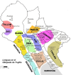
Most of the countries that can be considered being at a State-wise level in 1337 are mostly concentrated in what is today Perú. We have famous ones, as the Chimu or Chincha, and you may also see a tiny country, Qusqu, which would later become the Inca Empire, the long-term goal while playing in the region.
Dynasties


SoPs


There are SoPs spread out all across the continent, making for a really interesting mix in the Peruvian area (again). We're already thinking about how to better visualize the coexistence of these two types of countries in the political layer, but it's going to take us some more time to get there.
Locations


One note: I'll talk a bit more in-depth about the design of the Brazilian locations if you scroll down, in the Terrain section.
Provinces


Areas


Terrain


There are huge geographical variations in South America, being one of the most diverse continents. One of the things I wanted to discuss is that we've tried to portray the Mata Atlântica, the original forest cover that was present in Brazil before the Portuguese colonized it, and a different type of land exploitation started. In this regard, we've been reading the feedback of the Brazilian community, and I want to say that our intention here is to portray the most realistic situation for 1337. That said, we've already internally discussed that we may reduce its scope, so it doesn't look so extreme, but we'd like to hear your opinions about it. And here you have one of the images that we used as a reference for it, so you get a good grasp of our intention:

Development

Natural Harbors


Culture


The jewel of the crown in this region. We've tried to portray the Pre-Columbian cultural diversity of these lands as accurately as possible, and, well, here you have the results.
Languages


And the languages that group these cultures.
Religions


We've tried to do our best to group the cultural religions of South America into different groups, based on common believes, gods, rituals, etc. Let us know what do you think of them. Oh, also, the Inti religion has its own differentiate mechanics, which we'll explain in the future!
Raw Goods


Lots of different natural resources in South America. You may note that some are more common compared to other regions (such as Medicaments). We've also been tweaking the color of different resources, with the help of your feedback!
Markets

The green market is centered around Teyuna, and the red one is Chinchay.
Population
Some issues with the map of the region this week (sadly), so let's discuss the numbers. The total in the continent is 10.22M, divided this way:
But don’t worry, as on the first post-Christmas Friday, January 10th, I will start a new series, Tinto Flavor, in which we will show the content that we have been working on for Project Caesar. And I promise you, it’s a ton of content, so you will have to play the game in due time to discover it all…
Before we continue, one note: as we're covering a lot of lands today, don't be shy and ask for more detailed maps of the type you want wherever you want them, and I'll try to provide in the replies. And now, let’s start with the South American maps:
Countries
Most of the countries that can be considered being at a State-wise level in 1337 are mostly concentrated in what is today Perú. We have famous ones, as the Chimu or Chincha, and you may also see a tiny country, Qusqu, which would later become the Inca Empire, the long-term goal while playing in the region.
Dynasties
SoPs
There are SoPs spread out all across the continent, making for a really interesting mix in the Peruvian area (again). We're already thinking about how to better visualize the coexistence of these two types of countries in the political layer, but it's going to take us some more time to get there.
Locations
One note: I'll talk a bit more in-depth about the design of the Brazilian locations if you scroll down, in the Terrain section.
Provinces
Areas
Terrain
There are huge geographical variations in South America, being one of the most diverse continents. One of the things I wanted to discuss is that we've tried to portray the Mata Atlântica, the original forest cover that was present in Brazil before the Portuguese colonized it, and a different type of land exploitation started. In this regard, we've been reading the feedback of the Brazilian community, and I want to say that our intention here is to portray the most realistic situation for 1337. That said, we've already internally discussed that we may reduce its scope, so it doesn't look so extreme, but we'd like to hear your opinions about it. And here you have one of the images that we used as a reference for it, so you get a good grasp of our intention:
Development
Natural Harbors
Culture
The jewel of the crown in this region. We've tried to portray the Pre-Columbian cultural diversity of these lands as accurately as possible, and, well, here you have the results.
Languages
And the languages that group these cultures.
Religions
We've tried to do our best to group the cultural religions of South America into different groups, based on common believes, gods, rituals, etc. Let us know what do you think of them. Oh, also, the Inti religion has its own differentiate mechanics, which we'll explain in the future!
Raw Goods
Lots of different natural resources in South America. You may note that some are more common compared to other regions (such as Medicaments). We've also been tweaking the color of different resources, with the help of your feedback!
Markets
The green market is centered around Teyuna, and the red one is Chinchay.
Population
Some issues with the map of the region this week (sadly), so let's discuss the numbers. The total in the continent is 10.22M, divided this way:
- 1.66M in Colombia
- 1.2M in Brazil
- 5.07M in Andes
- 877K in Chaco
- 1.4M in La Plata