• We have updated our Community Code of Conduct. Please read through the new rules for the forum that are an integral part of Paradox Interactive’s User Agreement.

Tinto Maps #30 - 20th of December 2024 - South America

Hello and welcome to one Friday of map-loving! Today is special, as our 30th Tinto Maps, devoted to South America, is the last regular one. This implies that it won’t be the last, though - we plan to have two Tinto Maps Extra on December 27th and January 3rd, and then we will continue with the Tinto Maps Feedback posts as we progress with the map review.

But don’t worry, as on the first post-Christmas Friday, January 10th, I will start a new series, Tinto Flavor, in which we will show the content that we have been working on for Project Caesar. And I promise you, it’s a ton of content, so you will have to play the game in due time to discover it all…

Before we continue, one note: as we're covering a lot of lands today, don't be shy and ask for more detailed maps of the type you want wherever you want them, and I'll try to provide in the replies. And now, let’s start with the South American maps:

Countries
Countries1.png

Countries2.png

Countries3.png

Most of the countries that can be considered being at a State-wise level in 1337 are mostly concentrated in what is today Perú. We have famous ones, as the Chimu or Chincha, and you may also see a tiny country, Qusqu, which would later become the Inca Empire, the long-term goal while playing in the region.

Dynasties
Dynasties1.png

Dynasties2.png


SoPs
Sops1.png

Sops2.png

Sops3.png

Sops4.png

Sops5.png

There are SoPs spread out all across the continent, making for a really interesting mix in the Peruvian area (again). We're already thinking about how to better visualize the coexistence of these two types of countries in the political layer, but it's going to take us some more time to get there.

Locations
Locations1.png

Locations2.png

Locations3.png

Locations4.png

Locations5.png

One note: I'll talk a bit more in-depth about the design of the Brazilian locations if you scroll down, in the Terrain section.

Provinces
Provinces1.png

Provinces2.png

Provinces3.png


Areas
Areas1.png

Areas2.png


Terrain
Climate.png

Topography.png

Vegetation.png

There are huge geographical variations in South America, being one of the most diverse continents. One of the things I wanted to discuss is that we've tried to portray the Mata Atlântica, the original forest cover that was present in Brazil before the Portuguese colonized it, and a different type of land exploitation started. In this regard, we've been reading the feedback of the Brazilian community, and I want to say that our intention here is to portray the most realistic situation for 1337. That said, we've already internally discussed that we may reduce its scope, so it doesn't look so extreme, but we'd like to hear your opinions about it. And here you have one of the images that we used as a reference for it, so you get a good grasp of our intention:
Mata Atlantica.png

Development
Development.png


Natural Harbors
Harbors1.png

Harbors2.png


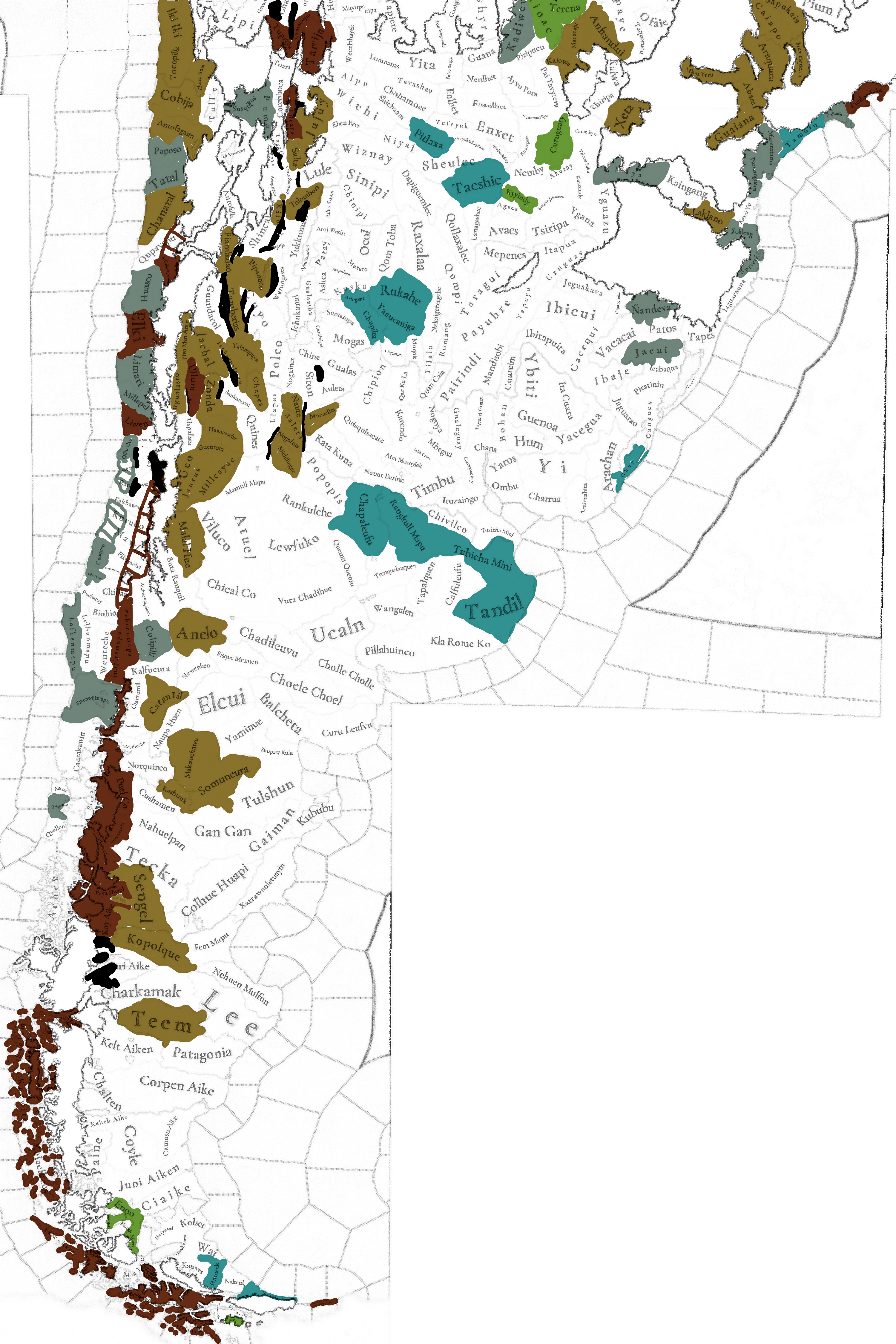
Culture
Cultures1.png

Cultures2.png

Cultures3.png

Cultures4.png

Cultures5.png

Cultures6.png

The jewel of the crown in this region. We've tried to portray the Pre-Columbian cultural diversity of these lands as accurately as possible, and, well, here you have the results.

Languages
Languages1.png

Languages2.png

Languages3.png

And the languages that group these cultures.

Religions
Religions1.png

Religions2.png

Religions3.png

We've tried to do our best to group the cultural religions of South America into different groups, based on common believes, gods, rituals, etc. Let us know what do you think of them. Oh, also, the Inti religion has its own differentiate mechanics, which we'll explain in the future!

Raw Goods
Raw Materials1.png

Raw Materials2.png

Raw Materials3.png

Raw Materials4.png

Lots of different natural resources in South America. You may note that some are more common compared to other regions (such as Medicaments). We've also been tweaking the color of different resources, with the help of your feedback!

Markets
Markets.png

The green market is centered around Teyuna, and the red one is Chinchay.

Population
Some issues with the map of the region this week (sadly), so let's discuss the numbers. The total in the continent is 10.22M, divided this way:
  • 1.66M in Colombia
  • 1.2M in Brazil
  • 5.07M in Andes
  • 877K in Chaco
  • 1.4M in La Plata
And that's all for today! We hope that you enjoyed the Tinto Maps series! We've definitely done, and it's also greatly helping us to make Project Caesar a much better game, with your help and feedback. Cheers!
 
  • 137Like
  • 57Love
  • 31
  • 9
  • 6
Reactions:
For anyone interested, this is how the Provinces map appears to players, with impassable wastelands distinguished as null entities by greying them out. The version with watelands coloured by province is just in the debug build so we can see what we are doing when we paint the map.

View attachment 1233792
Is painting the map something that can be done in an ingame interface or do we still need to do it by text editor and image files?
 
  • 1
Reactions:
This has probably been mentioned already, but please make sure to have consistent representation of the Quechua language. I found one potential example of inconsistent naming. Correct me if I'm wrong, but I think that the area of "Huaman Karpa" should be "Waman Karpa" if you want to use the modern Quechua orthography instead of Spanish (and it is written like that in this Wikipedia article, so yeah). In EU4 usually the Spanish orthography for Quechua is used, which breaks some immersion for me when playing as a Sunset Invasion scenario Inca Empire (or rather, Tawantinsuyu). So, I think it would be great to use the Quechua orthography which was made to suit the language rather than making it easier for the Spanish to read it, and to be consistent about it.
 
  • 5Like
  • 2
  • 1
Reactions:
No one bothered to address my previous concerns so I summarized it here. Please, for the love of God, correct this mistake. I do not understand how such a mistake was even made, considering you got (sort of) right the Querandí.

Make Het and Gununa Kune (puelches) the kénos religion, and make them all speak the same language group. I want to play as my people. Imagine being french, trying to play as a frenchman, and discovering your people speak english now and are muslims. That's how outrageous this is.
No need for such a condescending attitude. There's thousands of cultures and languages that the developers have to look over. Inevitably, mistakes are made and suggestions are overlooked as there are many to get through. Your example would be outrageous if the developers intentionally made that mistake, but your mistake is immediately assuming that they did it intentionally.
 
  • 7
  • 3Like
  • 1
Reactions:
Topography review

Summary:
  • This time I went 'freeform' here and there, where I think some Locations should be reshaped to follow the topography a bit closer.
    • E.g. Colombia's valley between the Cordillera Central and Oriental is currently non-existent, but in reality has flatlands all the way past Bogotá
    • Readjusted some mountain range edges in freehand drawing to more accurately approxcimate their map position.
  • Some expansions of the Andes mountains
  • Some reshuffling of Wetlands (e.g. Pantanal is restricted to the impassable terrain, not to the locations on its east)
  • In Brazil a reshuffling of hills with plateaus
  • Coastal Andes of North-Central Chile is significantly elevated above sea level (-> Plateaus)
  • Some choices of Andes wastelands seem a bit odd to me (minor hills as impassable, while huge ranges are acessible)
    • I added a few imo essential ones, but most I leave up to interpretation.
    • As others mentioned, the Mata Atlantica wasteland seems too harsh. But if it were to be diversified into locations it should largely consist of plateaus and hills from West to East
General Topography
Tinto's Topography CurrentSuggested TopographySuggestions 'changelog'
1N_TopoTinto.png

View attachment 1N_TopoTinto.png
2N_TopoS.png
View attachment 2N_TopoS.png
3N_Changelog.png
View attachment 3N_Changelog.png
1S_TopoTinto.png
2S_TopoSulph.png
3S_Changelog.png

Elevation & Terrain Ruggedness
  • I'd like to bring up that above 2.5 km elevation, human physiology is stressed significantly. Only peoples that have lived here for centuries, and have an adapted physiology can have relatively normal life expectancy. For this reason, the purple indicated such places, and these in particular are over 4 km (!) in height.
Terrain Ruggedness (translated to Tinto's categories)Expanded TRI, with indication of plateaus > 2.5 kmDigital Elevation with exaggerated color scheme
4N_DEM-TRI.png
View attachment 4N_DEM-TRI.png
4N_DEM-TRI_HighPlateaus.png
View attachment 4N_DEM-TRI_HighPlateaus.png
5N_DEM-Colorful.png
View attachment 5N_DEM-Colorful.png
4S_DEM-TRI.png
4S_DEM-TRI_HighPlateaus.png
5S_DEM-Colorful.png

Wetlands
  • Most of the wetlands occur in the wasteland areas. E.g. The Paraguay-Paraná Wetlands are fully located in the wastelands
  • Argentina has a unique wetland-like region with an enormous amount of lakes, West of Buenos Aires
100 year-event Flood RiskGlobal Wetlands and Lakes DatabasePeatML: total percentage of Peatlands per km²
6Na_Wetlands-Floods.png
View attachment 6Na_Wetlands-Floods.png
6Nb_Wetlands-GLWD.png

View attachment 6Nb_Wetlands-GLWD.png
6Nc_Wetlands-PeatML.png
View attachment 6Nc_Wetlands-PeatML.png
6Sa_Wetlands-Floods.png
6Sb_Wetlands-GLWD.png
6Sc_Wetlands-PeatML.png
 
Last edited:
  • 18Like
  • 6
  • 6
  • 3Love
Reactions:
Excellent work; I have some suggestions regarding Chile:

The border of Arica is not historical; the same with Ciakie; the way the location of Piren is defined also seems somewhat arbitrary, the impassable lands do not seem very realistic either, and I would change corn for potatoes due to the climate. Chubut cannot cross the Andes and be a province that reaches the Pacific, nor is there any historical justification for this. The Pacific islands and the continental plate in that part of Chile are called "AYSEN".


The Chono-Guaiteco language was unintelligible with the Kawésqar.There is a lot of missing copper in the southern Andes; Chuquicamata has been exploited since 450 BC, to give you an example.A bit of flavor about the Chinchorros (I don't even see them represented); the Chinchorro culture that inhabited the coast of northern Chile and southern Peru at that time in the current city of Arica and in the valleys of Azapa and Camarones. They are an ANCIENT culture, the oldest to mummify their dead; you can add it to their religion if you ever make them playable. IT SHOULD BE A POP SOCIETY.

View attachment 1233755View attachment 1233756


The Mapuche people need to be given a lot of flavor; they are a people who managed to resist the conquest and with a very particular organization. The Mapuche culture was a more or less organized people but only for war; it can be a pop society but when there was an external threat it had an organization similar to a centralized state; in Chile the culture could be distributed in this way in those years but had internal subdivisions. The first researchers recognized the Picunche, who inhabited from the Maule River to the Itata and Biobío rivers, the Araucanos, from the latter to the Toltén, the Pehuenche in the mountainous area, from Chillán to Antuco and the Huilliche between the Toltén River and the Gulf of Corcovado, including 1 Chiloé Island.Another thing about the language; when the Spaniards arrived, Mapudungun was in use from Coquimbo to Chiloé and from the mountains to the sea; this was due to the "Mapuchization" of the peoples by this culture.Now, some flavor; the Mapuche had a pre-Columbian domesticated gallina; a very strange thing in the New World; probably due to contact with Polynesians. The chickens are called "kollonca" and "ketro". This last hypothesis gained strength when, in early June 2007, Chilean and New Zealand anthropologists announced that they had found about fifty chicken bones in "el arenal", on the Arauco peninsula in southern Chile; you could put it as a unique production method. (It's a bit controversial; I know but it would be fun to include the detail)

View attachment 1233760


At the mouth of the Palena River there is a location called Puerto Raúl Marín Balmaceda, colonized in 1889; an excellent natural harbor that should be represented in the game; being one of the best unused ports in the Pacific due to its isolated location where even today large tourist ships can land.
View attachment 1233759

Excellent natural port and is not even represent in the map!

There are grasslands in the Mediterranean center of Chile when there should be sparse vegetation. In that place, the "Mediterranean scrub" predominates, specifically sclerophyllous and spiny forests (matojo de espinos) ; then it was deforested. And speaking of that, there should be an event at some point in the early colony. There is a lot of vine where the Mediterranean climate predominates in Chile. Grapes from Bordeaux and Spain were brought, managing to "vinify the country a lot". As a fun fact, in the old world there was a crisis with an insect, the phylloxera; which completely extinguished the Carmenère; only isolated vines survived in Chile that were cultivated as Merlot until we realized that it was actually Carmenère in 1998. You could add some flavor to that historical event.

i will do more fedback in some time; nice work!
https://hexbear.net/comment/4236159
Aren't the chinchorro a bit *too* ancient for the time period of this game?
I would add some sort of event or aesthetic content involving the Selknam, already present in the map as a culture, based on the famous photos of them in their curious costumes which have become so popular in modern society.

Flavor involving European wine strains in Chile is a fun suggestion btw.
 
Some Details I want to be adressed if possible:

In Argentine and Uruguay region, there were a lot of "montes" a kind of woods covering the area before it was used by Europeans as pastures thus transforming them to grasslands, in that line, there were no livestock there, all livestock were eurasian in origin (sheep, cattle, pigs, goats) so Native Americans should not be able to exploit livestock nowhere in America exept por the llama and alpaca of the andes.

Thus to the other subject, change of production in a zone, is if there will be a production change to somehow be able to grow potato in Europe, and rise cattle in America, in zones that at the begining of the game where unable to. The Columbian Exchange was a Mayor part in this timeframe, Cotton, Sugar, Wheat and Livestock ( to name a few) were from Eurasia but thrived in America.... Potatoes, Tomatoes, Cacao, Tobacco, Maize where from America and planted or very demanded in Eurasia.

So this production change should be and option.

And finally, the Charrua people where havy decentralized and nomadic with no crops at all, the Guarani in the other hand, were semi-nomadic and had pottery and crops. So I recommend to change the nation to choose there. As an example missionaries had a reaaly tought ride to convert Charruas, but relatively easy to convert Guaranies, the movie Mission explain something of this.
 
Last edited:
  • 9Like
  • 3
Reactions:
Purum awqa should not be its own culture as that's just a degoratory quechua term used for the Pikumche that literaly means "savage enemy". So it should just be merged with the Pikumche.

The territorial extent looks fine as they extended not beyond the Aconcagua valley in the north, and in the south they reached somewhere between the Maule river and Bio Bio River. Probably around the Itata river basin. The southern border was much softer since the Pikumche are a subgroup of the Mapuche.

Here are some maps of the precolumbian situation:

View attachment 1234220
View attachment 1234222

Also, the Cuyo area should not cross over to Chile, that's just weird mechanics-wise since a tag could just convert cultures from any side of the Andes to the other. Considering Chile's isolation and self reliance through history this would not very accurate to represent the geographical challenges for the various societies that inhabited this region and how difficult it was for foreign entities to conquer it effectively.

Here's a topographic map for this point:

View attachment 1234228

And as you can see, the North should be covered in plateaus and the followed by hills as you get into the central valleys.
I will add some Pikumche/Mapuche localizations for the locations in this area:

1000050939.png


Qillu uta -> Alimapu (it's Valparaíso) / Küyüta / Küyünmapu (these last two are for Quillota)

The one right next to it (I can't tell the name from the screenshots)-> Akonkawawe

Meli pillan -> Meli-pillan it's okay but if you wanna represent the province of San Antonio (which was more important in the game's time frame and became one of the largest ports after colonization), then it would be "Pukalán". There's "Llonkokura" but that name it's a reconstruction with no evidence of being used by the Pikumche.

Waykuche -> Mapu-cho (for the Mapocho river) / Maypu / Maypun / Maypuwe (name of the valley)

Rangkawe -> Rangkülwe (it's Rancagua) / Kachapuwe (for the river and valley of Cachapoal which is fully covered by the location)

Kolchawwe -> Kulchawe

Kuruko -> Kura-ko

Mawlen -> Mawüle (although this is also a reconstruction) / Tralkawapi (it's Talca and it means "Thunder of the valley")

Cauquen -> Kankeñewe

Pikumche -> Ankowawe

Here there's two that I can't tell the name but here I go

Coastal -> Itatamapu

Inland -> Ñumlewe

Chillan -> Dikülünwe

Puchacay -> Pu-chakay

Biobio -> Biu-biu


I will post somes panish localizations later too
 
  • 3Like
  • 1Love
  • 1
  • 1
Reactions:
Amazon/Brazilian vegetation

Although I agree it is difficult to estimate the actual vegetation density for the time period, the amount of grasslands that are currently in game are far too much.

Taking a look at estimated tree cover loss in even the past 20 years, reveals that there should be at least a lot more 'woods'
EDIT: especially the "Tree Biomass" Map seems interesting.
EDIT2: made a follow up post with more concrete suggestions here

Also take a look at the logging patterns in Rondonia and Mato Grosso: they reveal where the original extent of the rainforest was (indicatively).
Recent forest loss (zones with active logging = historical forest)logging (red) vs quasi-natural sparse vegetation (orange)
Note that Santa Ana del Yacuma (Llanos de Moxos) has a quasi-natural sparse tree vegetation, due to it being frequently flooded (Semi-permanently) in the wet seasons.
1734814803165.png

1734904604496.png
1734904502702.png

1734904564186.png

1734904752581.png
 
Last edited:
  • 14Like
  • 5
  • 1
Reactions:
So talking about the North (Amazon) region first, most locations are fine, the Only place i would add is Cametá (originally Camutá), a village that was fundamental on early exploration of northern Tocantins river, a region already covered in the maps. The village was founded in 1612 as a mission to convert the indigenous people Camuta that inhabitted the region for long time prior, so, since it was inhabitted for long and is importante in the timeframe of the game, I feel it is something that should be in the game. Also would rename Obidos to Pauxis, since it was the indigenous name of the place, instead of the Portuguese one. The other thing bothering me in the region is the absence of sops, specially considering that many of those people are still living here. Some options for sops would be the munduruku in the southern parts of Tapajos river, the Tapajos on the region of Baixo Amazonas, the Manaós in the region that would become Manaus, Parakanã people around the Tocantins river and Tupinambá people in the region that would become Belem (in reality there were Tupinamba people all around Brazilian coast). Specially the tupinambá would be interesting as the occupation of the region was marked by a bloody war.

For northeast region, most of it makes sense, except for the excessive wasteland and lack of granularity in the region of coastal region of Sergipe, Alagoas and Bahia, since it was one of the most inhabited region of Brazil during the timeframe of the game. Particularly the locations of arakaiu, sauipe, jiribatuba, pataxo and aimore are just too big when comparing to Amazon.

For the southern region granularity feels fine, but again it makes no sense for the wasteland there. Specially since that region is known as “Mata das Araucarias” a part of Mata that is NOT that tropical and that has signs that mankind influenced it’s growth.

Now the southeast… there are a lot to be changed here. Both granularity and wastelands make no sense. There have been people living on Mata Atlantica since year 400 at least so it makes no sense that it is an impassable terrain even by the logic that this is how it was in 1337. Now I do believe it should have an impassable terrain, the obstacles that were the real challenge on early colonization of southeast Brazil: The Serras, small mountain ranges around the coast of São Paulo, Rio de Janeiro, Espirito Santo, Parana and Santa Catarina, as well as all around Minas Gerais. Although not that high in altitude (basically they go up 1000m-1500m in most areas) they are such a sharp increase in the altitude since they are so close to the coast that it looks like a wall of stone and dense rainforest that only the indigenous knew how to traverse during early colonization. So I would suggest adding this region as the impassable terrain with some passages, Specially “Serra do Mar”, “Serra da Mantiqueira” and “Serra do Espinhaço”. As for the Granularity, besides of adding many provinces in the wasteland, I would suggest that the locations of Guaitaca, Goitaca, Cunhambebe, Tamoio, Marataiama, Paranagua and Guaiana to be divided into more provinces, since the southeast was one of the first regions to be colonized, specially the coastline, as well as being the most populous area of Brazil to this day.

Also would really like if the locations for "Ouro Preto" and "Diamantina" in Minas Gerais were added with a province modifier since they were some of the biggest producers of gold and diamond in XVIII century and became two of the most important citites in the country by that time.

No feedback on central region because i'm not that familiar with neither it's history nor it's geography, and since it was the region that was least colonized by the time of the game i don't feel it should have more granularity nor less wasteland.
Also not adding on the need of more SOPs outside of North region for lack of knowledge on that.
Would like to provide some links, but since i'm new to the forums i, apparently, cannot.
 
  • 8Like
Reactions:
.

Flavor involving European wine strains in Chile is a fun suggestion btw.

Chilean wine experienced a "boom" in the 19th century, after the many European grape varieties were introduced. For much of Chilean history, the País grape was predominant.

Flavor involving Chilean wine is something that could be done in Victoria 3, not in the Not-Eu5 timeframe.
 
  • 3Like
  • 1
Reactions:
1734818236152.png

Here's a map of the Uru-Chipaya languages, which can all be represented by the Uru culture. It's also including some of the Changos in Chile, which is up for debate, but might be a better choice than having them speak Aimara. In most of this territory, Uru pops will be relatively small minorities. The Urus are also noted for being fishermen and not really agricultural, so maybe they should be tribesmen?

Here's an excerpt from pages 583-84 of Languages of the Middle Andes in areal-typological perspective (Adelaar 2012)

1734819614342.png
 
Last edited:
  • 5Like
  • 2
Reactions:
View attachment 1234408
Here's a map of the Uru-Chipaya languages, which can all be represented by the Uru culture. It's also including some of the Changos in Chile, which is up for debate, but might be a better choice than having them speak Aimara. In most of this territory, they will be relatively small minorities. They are also noted for being fishermen and not really agricultural, so maybe they should be tribesmen?

Here's an excerpt from pages 583-84 of Languages of the Middle Andes in areal-typological perspective (Adelaar 2012)

View attachment 1234417
The Chango people were primarily fishermen and are believed to have traded with the Aymara for other products. The language spoken by the Chango people is thought to have been Kunza or Aymara, but who knows.
 
  • 1Like
Reactions:
Chilean wine experienced a "boom" in the 19th century, after the many European grape varieties were introduced. For much of Chilean history, the País grape was predominant.

Flavor involving Chilean wine is something that could be done in Victoria 3, not in the Not-Eu5 timeframe.
While your point is accurate, historically speaking, I think it rises a deeper feedback discussion regarding the what-if nature of this game.

Indeed those wine varieties arrived in the 19th century. But they 'could' have also arrived earlier, from 1700 onwards. Because it was in 1700 that the House of Bourbon took power in Spain, greatly opening trade and transit of goods between the Iberian colonies and the rest of Europe, particularly after the Free Trade agreements of the 1760s. Free trade in the colonies was something the Habsburg tried to prevent as they maintained a monopoly on the American products.

So historically speaking, events for the introduction of certain goods in colonial nations could happen randomly starting in the 18th century. 'Historically'.
But ingame, what if the Bourbons sit in the Spanish throne earlier? Or what if Spain picks a different colonial policy from the beginning, or changes it during the game? Then these types of historical events could definitely trigger at different dates.

In the particular wine example we are discussing, the event occurred because the climatic conditions of this area in Chile were particularly suited for European wine varieties, not because it was the 19th century per se.
Many events in the game could occur earlier or later, depending more on if their necessary conditions are met, than fixed dates, and of course with a level of randomness in the activation probability.

The New World is a complex area in terms of events and flavor, really. These nations depend on both their own conditions and also greatly on conditions regarding whatever has happened in Europe. I think a fair amount of leniency regarding specific dates is required, and more attention to specific triggers.
 
Last edited:
  • 5Like
  • 3
Reactions:
Yeah, that wasteland in southeast Brazil is... weird, to say the least.

Don't get me wrong, both the Serras and Mata Atlântica were hard places to travel, but it was mostly due to sudden change in elevation. The Serras were also, sometimes, referred to as "the green wall" or just "the wall" (as in the Great Wall of China) due to how hard it was to pass through (though that probably is a nickname that came very late in the game's timeframe).
That region was very economically active, especially in early colonization attempts. São Paulo being one of the oldest cities in Brazil and being a gateway to the countryside.
I think that wastelands here would be best represented by having some thinner wastelands running along the sea with a couple passages, possibly with mountain terrain (but i'm not sure on that).

View attachment 1233747
(Aproximate extent of the Serra do Mar).

Also, Just four SoP's in Brazil? That's... well, that is going to be a rehash of my 2021 opinion on North America in EU4.
There could (and should, in my opinion) be a few more SoP's in the region. I'm thinking specially in Rio-São Paulo coast, were both the Tamoios in São paulo and souther Rio and the Temininós, in northern Rio and Espirito Santo, were fairly distinct and Important tribal groups. (althouth their importance is only relevant after portuguese colonization). I'm not very knowledgeble in North Eastern Brazil, but I'm pretty sure there should be at least one on the region around Paraíba and another one on São Luis.

Marajo Island looks weird to me, but I don't have much insight aside from suggest giving a look at Acient Americas video on the Marajoara Culture and reading his sources. There is an argument to be made that they could be considered a settled country in decline at the start date, but since mostly of what we know is trough archeology, it probably wound be a stretch.

Also, that location density on the Southe East brazilian coast is honestly disgusting. it doesnt even include the São Vincente Island, where the oldest brazilian city, São Vicente, was founded in 1532. Rio de Janeiro with just 2 locations is pratically an insult, especially considering how the island of Marajó, wich is roughly the same size as the state of RIo, has 4.

View attachment 1233779
(This is my rough suggestion of how to improve the region, the red being wastelands and the yellow being a few location bordes).

Now, this part is somewhat more difficult to realize, but the whole of the Amazon Basin should have a lot more population and locations, and maybe some settled countries. Why setted countries? well, as the image bellow shows, vast swats of land contain what is called Terra Preta, a human made fertile soil that was usually made in the vincinity of settlements, and is the only real fertile soil in the entirety of the amazon rainforest, which usually has very poor quality soil. Most of the regions with abundance of terra preta would be heavily inhabited due to said soil being the only decent place to farm.

View attachment 1233788

Anyway, this is just a rough suggestion, I'm sure other people will have even better or more dettailed suggestions about the matter, but this original map for Brazil is extremely poorly made, I hope you guys make a lot of changes on it, because it doesn't snspire confidence right now.
Good points! Just to add, you detailed what in English is called "the great escarpment" https://en.m.wikipedia.org/wiki/Great_Escarpment,_Brazil
 

Attachments

  • 6c05bc9e-aa02-409b-9ad6-e9f4812eb75c_1600x875.jpg
    6c05bc9e-aa02-409b-9ad6-e9f4812eb75c_1600x875.jpg
    225,6 KB · Views: 0
  • 0fc12c96-d095-4c9a-aaaa-e68e6ad065fb_1600x895.jpg
    0fc12c96-d095-4c9a-aaaa-e68e6ad065fb_1600x895.jpg
    253,8 KB · Views: 0
  • 2Like
Reactions:
Err... Brazil map is simply horrible.

How can all the farms around Rio, once colonial capital, then Portuguese Empire capital, then Brazilian capital, be wastelands?

How people already mentioned, the Serra do Mar was populated by amerindians when the Portuguese arrived.

And the richest region in Brazilian colonial era, southern Minas Geraes, where most of the gold was located, is also a wasteland...

It is really incomprehensible.
 
  • 12Like
Reactions:
The Fernando de Noronha (or Loronha) island, with 26 km² (It's more that the minimum. Right?) is not at the map. It was the first colony of Brazil, caled São João. A important point of fight among colonial countries. Wiki page.
Edit: It would have only 82 px, but minimum is 100, so sadly I can't claim it be put on map. If possible you increase a few it area would be great, because unlike the islands of Martim Vaz, Abrolhos or São Pedro e São Paulo, this one was important for Brazil.
 
Last edited:
  • 7Like
  • 2
Reactions:
I know the main point of concern here is the representation of the Mata Atlantica, but I'd like to redirect a bit of attention to the northeastern corner, more specifically the Capibaribe province. More specifically still, related to the location of the sister cities of Recife/Olinda.
I've overlaid the map with google maps, and they look to be on a very odd positiion, sitting right between Caxangá and Yapuata, not being propely the center (or even close) of either of them.
1734830773376.png


As to why this is an oversight, I'm going to repost the content from the other feedback threads:
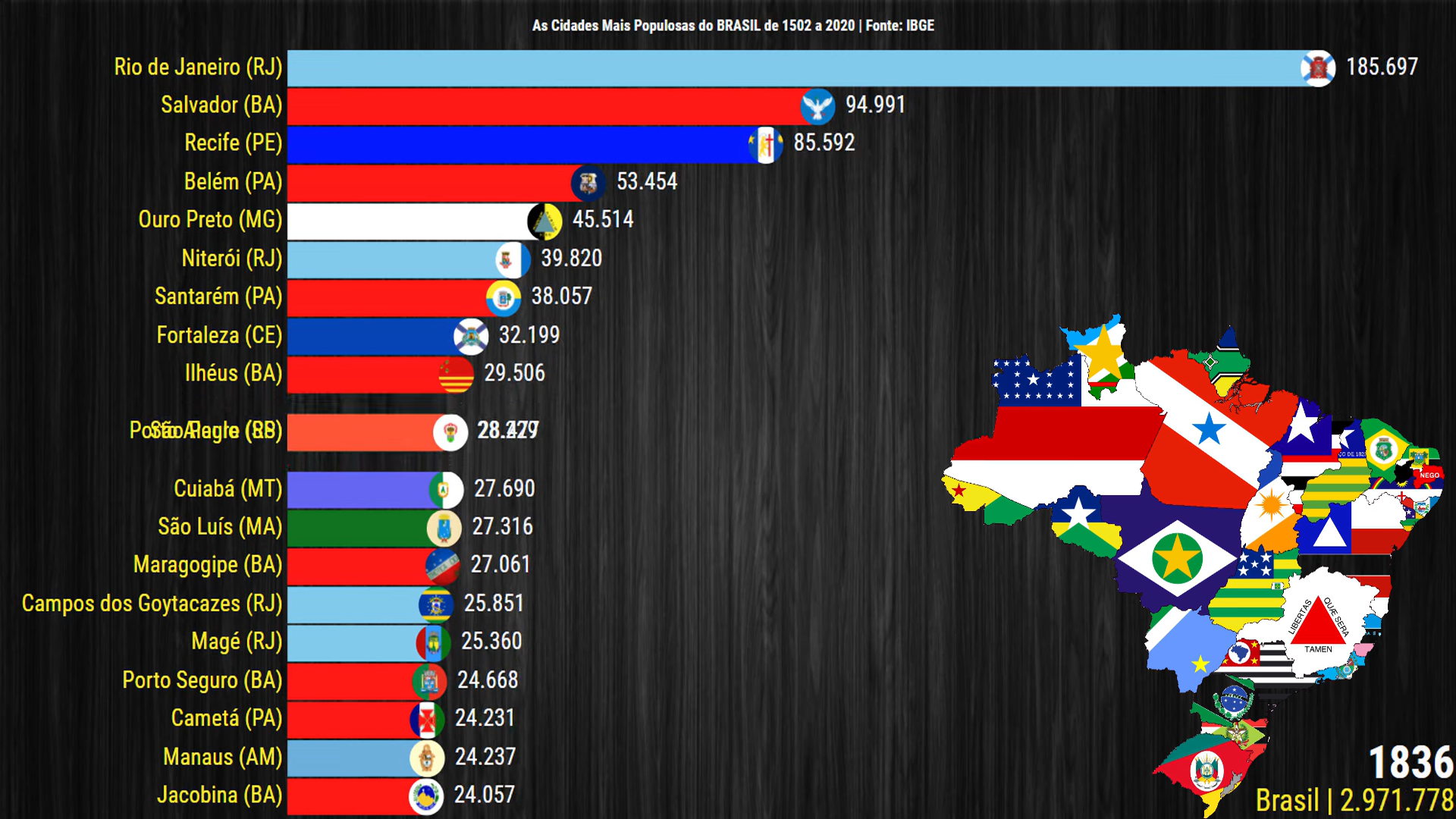
The sister cities (Recife/Olinda) were at the top of the population ranking for a good chunk of the colonial period, and both were still on the top 5 for most of EU5's time frame."
1734830961207.png
1734830983829.png

At the end of the time frame, Recife and Salvador were in the top 3 with quite the wide margin to the rest, only behind to Rio de Janeiro.
1734831052484.png

To add to these points, Salvador was the Brazilian capital for most of the colonial period (up to 1763) and Recife was the capital of Dutch Brazil.
Let's not be fooled by current population density, the northeast was the economic and populational center of the country for a very long period.

Edit: I mention Recife and Olinda, because they are almost one and the same, at the level of granularity presented in this map at least, they would really be functionally only one location. So for the graph above you can really se their importance as population centers, in game terms by the 1700s this would be the most populous location in Brazil.

1734834005943.png


Brazil was born throught the extraction of the ''Pau-Brasil'' (Pau= Wood / Brasil = Braça = Ember) also called Ibirapitanga (red tree) in Tupi-Guarani

it was a tree that had a ember-like wood that was used for the creation of furniture and Dyes. the natives would chop the wood and trade for manufactored goods with the Portuguese.
The Portuguese used the tree to kickstart ocupation of the brazilian coast, they built FEITORIAS , Fortified warehouses for the wood waiting the next shipment, the main feitorias for the extraction of Pau-Brasil were in Cabo Frio ,Porto Seguro and Igarassu/Pernambuco.
I would advocate to make Cabo frio + Recife/Igarassu locations with Dyes as their RGO, but i would like to also point out that the natives where organized and probably deserve to be SoP's, and maybe it would make more sense to make many locations in the Pau-Brasil range dye RGO's, where the natives would extract it and they would trade with the portuguese in these outposts, later on with actual colonization these would slowly fade out for colonial goods such as Sugar.

View attachment 1234246
1. Pra-Brasil Range, 2. Livestock, 3. Sugar
Agreed on everything, but the Igarassu one is likely where the Caxangá location is on their map, so it should be pointing to the fish good, not the salt one.

Absolutely this. Not only Filipeia but also Recife (Pernambuco) is not represented with a natural harbor, which is really strange. It shared the highest importance with Salvador and Rio de Janeiro, being closer to Europe than both. It also was the main Dutch hub when parts of the Northeast were conquered by the Netherlands in the 1600s, it held bith strategic importance and riches from the sugar production.

The location is "Caxanga" on your map
Agree. Recife/Olinda was truly a major hub, and previous iterations of PDX games, such as EU4, included Recife as a Natural Harbour.
Adding more info on that, besides making Recife its own location like I commented above, it was one of the most important harbors in colonial Brazil, so it should absolutely have a high rating.
From Wikipedia (PT-BR)
1734831417505.png

TL: Recife Port: Recife's port is managed by the government of the Pernambuco State. It is located in the city of Recife, on the margins of the Capibaribe and Beberibe rivers, which flows into the Atlantic ocean. The first slave port in the Americas, the then-called "Port of Pernambuco" was the main outlet for sugar and brazilwood for the Captaincy of Pernambuco, the richest captaincy in Colonial Brazil. Used since 1535, it was also the birthplace of the town of Recife.

From the EN article:
1734831472642.png


Recife/Olinda were some of the earliest settled cities in Brazil, is one of the most significant cities for this period in Brazil, a proper representation will absolutely make or break the northeastern section as far as historicity goes.
 
Last edited:
  • 8Like
  • 5
Reactions: