• We have updated our Community Code of Conduct. Please read through the new rules for the forum that are an integral part of Paradox Interactive’s User Agreement.

Tinto Maps #6 Great Britain & Ireland Feedback

9 September 2024 12 May 2025​


What an exciting week we have had, and best of all I finally get to say the name Europa Universalis V. It still feels weird in my mouth after carefully saying Caesar for what feels like a lifetime.

But lo, the day is finally come for the British Isles feedback thread. This short update was supposed to come out a few months ago, but I just had to teach some of you a lesson. Also I had a lot of other things on, like appearing in the announcement show last week.


Here we see the updated topography:

topography.jpg


The updated vegetation:
vegetation.jpg


Many impassable barriers have been added, for example the various peaks of the Pennines and the Wicklow Mountains. The Shannon also now poses a more significant barrier between east and west Ireland, with only a few crossing points often guarded by stockades.


Here we have the Locations map, bear in mind they are only showing the default English names but many places have Gaelic or Brythonic versions.

locations.jpg


Every country has had a general increase in density.

England, in particular the south, has had a big revamp at Location and Province level to more accurately reflect the historical counties, many of them pre-Norman in origin and many of them still in use today in some form. Westminster as a capital has been killed and rolled into a monolithic London.


Provinces:
provinces.jpg


Areas:

areas.jpg


And political mapmode (with overlord colouring off):
political.png


And Dynasties:
dynasty.jpg


We have added the Earldom of Orkney in the northern isles as a Norwegian vassal. Meanwhile the Palatinate of Durham and Chester have both been promoted from a special set of buildings to vassals under England. Wales has also been limited strictly to the Principality of Wales, with the marcher lords existing as very low control locations under England.

Ireland has had a major rework in terms of locations and tags. Mostly there have been minor Irish chieftaincies added. As always we are grateful to the many suggestions that have come from the forumers.


Culture:
culture.jpg


The most obvious culture change is that English has had Northumbrian split off, to represent the divide between southern and northern dialects and attitudes. A practical example of this is how in the south the English are more friendly to Normans, whereas the Northumbrians hate them (the northern shires still bear the scars of the Harrying of the North). Northumbrians and Scots also spoke a similar form of English in this period, so it helps to set them up as a sort of middleman.

Norwegians in northern Scotland and the nearby North Atlantic have also been split into Norn.


As a bonus, Court Language, showing 3 main worlds: Gaelic, Anglo-French, and Roman Catholic Bishoprics.

court_language.jpg


There have also been some changes to Raw Goods, as you can see here:

raw.jpg


We still have time to make some changes, so let us know what we can do to push this even further towards where it needs to be.

I won’t show Population numbers right now, as it’s pending a proper rework. Among other things, the idea is to reduce the population numbers in England.
 
Last edited:
  • 165Like
  • 77Love
  • 8
  • 5
Reactions:
I'm not so sure Mercia should be the name of a region. While it was still called Mercia at the beginning of the Game's time frame, for over half the game, it had become known as the Midlands. Or is there a trigger already there to change the name?
 
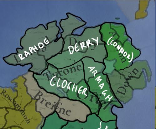
Ulster is really tricky to subdivide, but the plantation-era counties are really rubbing me the wrong way. Tyrone being lumped with Fermanagh rather than other traditional Cenél nEógain regions is really odd too for any time period, but especially this one.
1747084990876.png

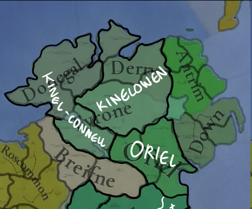
Dioceses are probably the best bet for evenly-sized provinces that would have currency throughout the entire timeframe - the Catholic dioceses here are in nearly the same shape now as they were when they were brought in in the 12th century. Additionally they matched historical political divisions very well, with Raphoe and Derry matching the Cenél Conaill and Cenél nEógain of the Northern Uí Néill Kingdom of Ailech, and Clogher and Armagh matching the Uí Chremthainn and Airthir divisions of Airgíalla. The main downside is that they divide the strongest regional power - Tyrone - awkwardly, especially considered that its core territory would not be divided during the entire time period, near-seamlessly becoming County Tyrone after the Flight of the Earls. The names are also a little odd, but Raphoe and Derry could be renamed Kinelconnell and Kinelowen respectively, and the Diocese of Clogher was historically also known as the Diocese of Oriel.
1747085333849.png

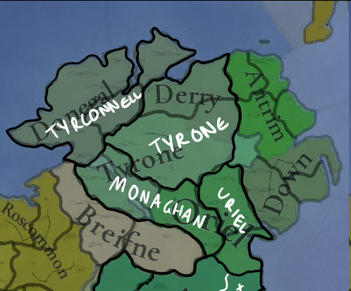
A division that would match the contemporary state of play would be this one, with the subordinate Kinelowen dynasties in Keenaght and Inishowen being included with Tyrone counterbalanced with Fermanagh joining their occasional overlords in Tyrconnell. The downside here is that the Kinelconnell province is awkward and oddly-shaped, and removing Fermanagh would make two much smaller provinces. I don't think that's a huge issue, though.
1747085356164.png

This division attempts to avoid the awkward Tyrconnell-Fermanagh merger by anachronistically giving Inishowen to Tyrconnell and lumping Fermanagh in with their distant Uí Chremthainn relatives in Monaghan, with Oriel being reduced to the anglicised "Uriel". This is fairly even but the anachronism bugs me a little!
1747085427266.png


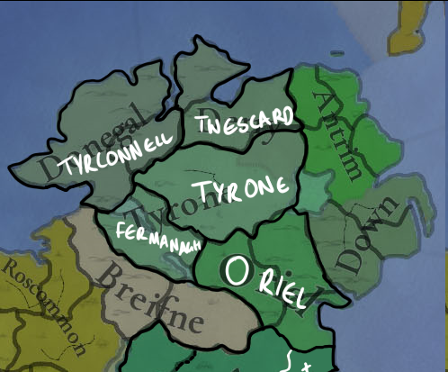
One way to avoid the big Tyrone/little Tyrconnell and Fermanagh problem is including Twescard, a division of the recently-collapsed Earldom of Ulster, for Tyrone and Tyrconnell to fight over. All these divisions would be meaningful from a contemporary perspective and are fairly natural divisions. A separate Fermanagh doesn't look too out of place here, but the Uriel-Monaghan split would also work fine here.

I've probably just confused everything even more, but I think any of these would be preferable than the 1613 boundaries of County Londonderry or Tyrconnell being called Donegal.
 
  • 3
  • 2Like
  • 1
Reactions:
I like the changes you have shown us. Particularly in Wales where the new borders of the principality make a lot more sense. I am curious how you go the low control for the marcher regions. Special buildings or special modifiers seem more realistic than just raw distance.

Durham and Chester as vassals looks odd at first sight, but treats England more consistently with the French vassals.

Curious about the population changes in England, as I thought that was about right. Was there a reason you are aiming to revise down?
 
  • 2
  • 1
Reactions:
I'll put all my feedback for the location map here - I've tried to be relatively limited in asking for new provinces here.
1747091561575.png

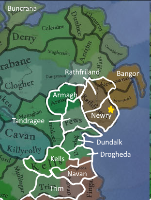
I've already gone over my ideas for what to do for Meath, Louth, and Armagh, but I thought I'd lay them out together here. Additionally Iveagh's single location looks really disproportionate compared to nearby locations, and a historical Upper-Lower Iveagh split fits perfectly. This allows us to add the sprawling abbey-city of Newry, and also to represent the distinctive geography of the Mourne mountains, a long-time redoubt of Normans long after the collapse of the Earldom. I also spotted that Buncrana has an extra n, and that Bangor makes much more sense as a name than Movilla if it's not being used in Wales.
1747090501139.png

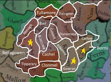
And here's the respective changes for northern Munster and Leinster - mostly minor reshapings except for the aforementioned additions of Bellagowen/Béal Átha Gabhann - modern Silvermines, the future Butler seat of Gowran/Gabhrán to split up what should be a dense and rich County Kilkenny, and the Caomhánach seat of Borris/Buirgheas Ó nDróna, which makes infinitely more sense as a second location for the fearsome Kings of Leinster than Wicklow, an English city surrounded by Ó Broin hinterlands.

1747090693082.png

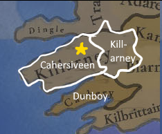
Finally, I think splitting the Iveragh peninsula off from an inland Killarney location is important. The peninsula is one of the most mountainous parts of Ireland, and was a formidable defensive asset for both the Mac Carthaigh Mórs and Ó Súilleabháins. The capital of Killarney is on the other hand in a relatively low-lying and fertile lakeland valley.
 

Attachments

  • 1747090485629.png
    1747090485629.png
    215,3 KB · Views: 0
  • 1747090519224.png
    1747090519224.png
    63,7 KB · Views: 0
  • 1747090850160.png
    1747090850160.png
    200,2 KB · Views: 0
  • 6Like
  • 2
  • 1Love
  • 1
Reactions:
So glad to see the Palatinate/Bishopric of Durham made it in! It really was a pretty unique entity within England.
 
  • 2Like
  • 1
Reactions:
I thought you meant that Norn should be in a culture group with Scots, Highlander, etc. That is what I disagreed with, but they yes I would say they are native to Orkney and Shetland. And for the different opinions on Norn and Icelandic I meant that they shouldn't have a cultural opinion on them as I believe they should be Norwegian at game start, except for Icelandic of course.
I mean, if English is in a culture group with Norse-Gaelic (British group, contains every culture on Great Britain and also Anglo Irish), and Andalusi is in a culture group with Catalan (Iberian, seem to contain every Iberian culture) why shouldn't Norn be in the British group?
Maybe it isn't and shouldn't, but I don't know and I really want to. The devs have given us so little information on what the culture groups look like, and to my knowledge none of the youtubers addressed it.
There is an Irish culture group with just two cultures in it. Is that common? Is that rare? Who knows.
Most of the culture groups we have actual info on are not remotely language based. Is that normal and culture groups are meant to show the connections between cultures besides language or have they shown us the weird ones?

Basically I'm desperate for culture group info and I was hoping that the devs would be more willing to elaborate on already given information than brand new information.
(Is Walloon in a group with Low Franconian and Frisian? Is Griko in a group with Sicilian, Neapolitan, Gallo-Italic, and Maltese? What groups are Albanians in? Do the Arabs and Berbers share any groups? Do the Norse and the various Finnic culture share a group? What groups are the Sami in? How do all the Jewish cultures fit it? I have so many questions and I feel like people will have feedback once they find out!)
 
  • 2Like
Reactions:
One concern I have with so many locations in England being woods or forest (and some with lumber as RGO) is that England will never run into the issue where they don't have enough local lumber and charcoal.
I guess the exact outcome in the game will have to be seen, but I think it would be unfortunate if this historical lack of resources was not represented, while the historical suitability for textile production is very well represented.

Also, as others have said, there should be some beeswax in this map. Yes, they probably traded for honey and beeswax from Eastern Europe just like the rest of Western Europe, but there was some local production too.
 
  • 1
  • 1
Reactions:
One concern I have with so many locations in England being woods or forest (and some with lumber as RGO) is that England will never run into the issue where they don't have enough local lumber and charcoal.
I guess the exact outcome in the game will have to be seen, but I think it would be unfortunate if this historical lack of resources was not represented, while the historical suitability for textile production is very well represented.

Also, as others have said, there should be some beeswax in this map. Yes, they probably traded for honey and beeswax from Eastern Europe just like the rest of Western Europe, but there was some local production too.
It's a shame we don't have actual deforestation and fuel use. It would add a ton of depth to gameplay across the world.
 
  • 12
  • 4Like
  • 1Love
  • 1
Reactions:
A couple of nitpicks from a local native:

I feel like Stirling should really have Wetlands or Flatlands terrain (in reality it’s more like Floodplains as it was in the Medieval period) rather than Hills because the area is absolutely flat apart from the Volcanic crag in which Stirling Castle dominates the skyline.

Linlithgow should have Wooded vegetation and not Sparse vegetation. Hunting lodges belonging to Royals and Nobles were located in the surrounding countryside there (Almond Valley for example) considering Linlithgow eventually became a Royal Burgh of Scotland in 1388 and with Linlithgow Palace being built in 1424 replacing a Royal Manor on the site dating back to the 1100s. There was a significant wooden defensive palisade that protected the manor and town of Linlithgow (and several other fortified motte and bailey type castles and peel towers in this county), so it’s a safe assumption plentiful wood from a local source was required. The Romans also built several camps and hillforts in the area and a large end-section of the wooden Antonine Wall which is also another indicator of a good wood supply in the area.

And I would make sure Linlithgow has port access, Blackness (located close-by on the Forth river) was a significant port/natural harbour for trade between 13th-17th centuries whilst protected by Blackness Castle (b. 1440s, earlier fort on the site), the port was replaced eventually by Bo’ness harbour (also close-by) in the Industrial age.

As a last point, apart from the exploitation of vast coal and shale deposits in which present day West Lothian (Linlithgow is part of) was famous for during the Industrial Revolution. There is a Silver Deposit that was exploited in the early 1600s around the Bathgate area, the operation was nationalised by the King of England at the time - I’m no expert on the subject but something to look into as a potential resource to add to Linlithgow in-game. The mining operation caught the attention of Europe so I think it’s worth doing something with this, could even be a flavour event for Scotland and GB.

 
Last edited:
  • 4Like
Reactions:
Cinque Ports are a special building that starts in some southeastern port locations and there;s some additional content surrounding them. The City of London also has a special building to represent the ancient liberties of the guilds.
Are other special local privileges in the world (that are not easy to represent by estate privileges) that are modelled by similar special buildings (such as the Saxon, Székely, and Cuman seats), or is this just a British thing?
 
Glad to see Ireland refined a bit more. My main issues with this update is that the counties of Kilkenny and Carlow appear to be part of the Munster Area, when they should probably be in Leinster. Also, Connaught seems to have annexed regions to its east that don't belong to it?
 
  • 1Like
Reactions: