Hello, and welcome one more week to Tinto Maps! This week we’ll be taking a look at Russia!
As an introductory note, we’re just considering today the ‘Russian core’, which in 1337 comprised the different Russian Principalities, as far as the White Sea to the north, and the Ural Mountains to the east. The lands that would later be incorporated into the Russian Empire will be covered in future Tinto Maps (otherwise, we would have to cover like… 1/8th? of the land mass in just one DD).
Countries

Russia is divided into several Principalities in 1337. The dominant one probably is Muscovy, as its Grand Prince, Ivan I Danilovich ‘Kalita’ (‘Moneybag’) is also Prince of Nizhny Novgorod and Kostroma, and of Novgorod (by election, in this case). He also holds the title of Grand Prince of Vladimir, bestowed by the Khan of the Golden Horde, which makes him the ruler enforcing the ‘Tatar Yoke’ over other Russian Principalities (which in our game is represented through an IO; the coloring of the different countries is different tones of yellow as they are tributaries of the Yoke). The other main power in the region is the Grand Republic of Novgorod, with a completely different institutional structure, that allows them to pick their rulers. Their power comes from being the main trading power between the Baltic Sea and the Russian region, and it’s the overlord of two border countries, the Principality of Pskov, and the County of Oreshek, a buffer country in Karelia, as agreed with Sweden after a recent war. Several lands to the north and east are not owned by any country. As a final note, you may also see that Lithuania is the overlord of some of the principalities, some of them directly through Gediminid rulers (Polotsk or Vitebsk), while other over Rurikovich rulers (Smolensk or Rzhev).


The starting diplomatic of Muscovy and the Tatar Yoke IO, for the sake of clarity.
Dynasties

Several branches of the House of Rurik rule over the Russian lands. Fun fact: we have 18 different branches portrayed in the game. The exceptions are a few principalities, and the ruler of Karelia, Prince Narimantas of the Lithuanian Gediminids. Also, the 'Cherdyn' and 'Vyatka' are randomly assigned dynasties, as we haven't been able to get the data for those countries on 1337.
Locations

We’re showing a less detailed region this week because, well, Russia is big. Feel free to ask for more detailed screenshots of specific areas, and I’ll try to provide them. We’re also showing some parts of the Steppe, Finland, and Kola, because of the scale of the map; take them as ‘unavoidable spoilers’, as we’ll talk more in-depth about them in future Tinto Maps.
Provinces

The provinces of Russia. As usual, suggestions are welcomed!
Terrain


Terrain map modes. As discussed in previous Tinto Maps, we’ll read carefully your feedback, as we have plenty of room to polish them!
Cultures

Cultures! As in other regions, we decided to have three different cultures in the Russian region, Novgorodian, Muscovite, and Severian. The design here is different than in the Ruthenian region, because Russia was more politically divided in the High Middle Ages, and would later be more culturally unified later on, while in Ruthenia, the situation would be the opposite. In any case, the four of them are East Slavic cultures, and we're open to feedback, of course. Apart from that, there are a bunch of different cultures bordering the region: Karelian, Pomor, Komi, Udmurt, etc. We might add some more minorities of these cultures, in the feedback pass after this DD. Also, take into account that the minorities over the Tatar lands (currently under the Kazani and Mishary cultures) are not yet done.
Religions

Eastern Orthodoxy is dominant in the region, although there are other religions in the area, as well; take ‘Animist’, ‘Tengrist’, and ‘Shamanist’ as wide categories, as we’d like to add a bit more granularity for them (although that will come later this year, don’t expect them to be added in the coming Tinto Maps, but maybe on the later ones). We’ve already seen some posts asking about Slavic Paganism; up until now, we’ve considered the Russian people to be Christianized, even if it was a more or less superficial process. If you’d like us to add this religion and some percentage of the population adhering to it, then I’d ask you for specific sources that could help us portray it (so, isolated references to it being followed here or there won’t be helpful, while academic sources saying ‘up to X% of the population was following Slavic rites’ might very much be).
Raw Materials

Quite different resources to other regions previously shown, with plenty of Lumber, Fur, and Wild Game in this region. I’ve also extended a bit the screenshot to the east, so you can see the mineral richnesses of the Ural Mountains, with plenty of locations with Copper, Iron, Gold, and Lead, making it quite juicy to colonize.
Markets

The counter to the richness of the natural resources of the region is its integration into the different markets, which at the start of the game are centered around Novgorod, Moscow, and Kazan. Fully exploiting the economic possibilities of Russia will therefore require effort and patience.
Country and Location population


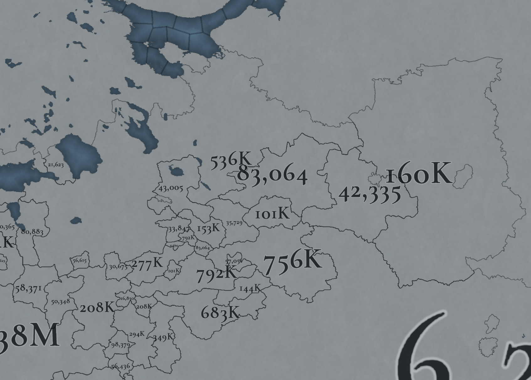
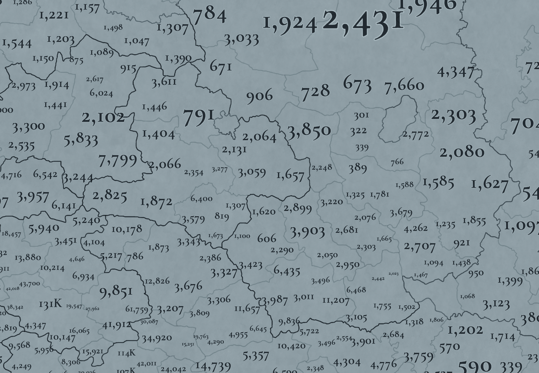
Not many people inhabit the Russian core, approximately 6M in total. This poses a series of challenges regarding the expansion of any Russian country. Also, we've divided into 4 different maps of the location population of the region, to make it possible to visualize. A side note: you might note that the population of NW Novgorod and Karelia is calculated a bit differently. That's because Johan took care of drawing the Scandinavian map in an early stage of development, and the Content Design team took over the rest of Russia at a later stage when we had already refined a bit more our population calculation methods. This means that when we do the feedback pass after this Tinto Maps, in a few weeks, we'll homogenize the style, as well.
And this is all for today! We hope that you’ll find it interesting, and give us great feedback! Next week we’re traveling to Carpathia and the Balkans! See you!
As an introductory note, we’re just considering today the ‘Russian core’, which in 1337 comprised the different Russian Principalities, as far as the White Sea to the north, and the Ural Mountains to the east. The lands that would later be incorporated into the Russian Empire will be covered in future Tinto Maps (otherwise, we would have to cover like… 1/8th? of the land mass in just one DD).
Countries

Russia is divided into several Principalities in 1337. The dominant one probably is Muscovy, as its Grand Prince, Ivan I Danilovich ‘Kalita’ (‘Moneybag’) is also Prince of Nizhny Novgorod and Kostroma, and of Novgorod (by election, in this case). He also holds the title of Grand Prince of Vladimir, bestowed by the Khan of the Golden Horde, which makes him the ruler enforcing the ‘Tatar Yoke’ over other Russian Principalities (which in our game is represented through an IO; the coloring of the different countries is different tones of yellow as they are tributaries of the Yoke). The other main power in the region is the Grand Republic of Novgorod, with a completely different institutional structure, that allows them to pick their rulers. Their power comes from being the main trading power between the Baltic Sea and the Russian region, and it’s the overlord of two border countries, the Principality of Pskov, and the County of Oreshek, a buffer country in Karelia, as agreed with Sweden after a recent war. Several lands to the north and east are not owned by any country. As a final note, you may also see that Lithuania is the overlord of some of the principalities, some of them directly through Gediminid rulers (Polotsk or Vitebsk), while other over Rurikovich rulers (Smolensk or Rzhev).


The starting diplomatic of Muscovy and the Tatar Yoke IO, for the sake of clarity.
Dynasties

Several branches of the House of Rurik rule over the Russian lands. Fun fact: we have 18 different branches portrayed in the game. The exceptions are a few principalities, and the ruler of Karelia, Prince Narimantas of the Lithuanian Gediminids. Also, the 'Cherdyn' and 'Vyatka' are randomly assigned dynasties, as we haven't been able to get the data for those countries on 1337.
Locations

We’re showing a less detailed region this week because, well, Russia is big. Feel free to ask for more detailed screenshots of specific areas, and I’ll try to provide them. We’re also showing some parts of the Steppe, Finland, and Kola, because of the scale of the map; take them as ‘unavoidable spoilers’, as we’ll talk more in-depth about them in future Tinto Maps.
Provinces

The provinces of Russia. As usual, suggestions are welcomed!
Terrain


Terrain map modes. As discussed in previous Tinto Maps, we’ll read carefully your feedback, as we have plenty of room to polish them!
Cultures

Cultures! As in other regions, we decided to have three different cultures in the Russian region, Novgorodian, Muscovite, and Severian. The design here is different than in the Ruthenian region, because Russia was more politically divided in the High Middle Ages, and would later be more culturally unified later on, while in Ruthenia, the situation would be the opposite. In any case, the four of them are East Slavic cultures, and we're open to feedback, of course. Apart from that, there are a bunch of different cultures bordering the region: Karelian, Pomor, Komi, Udmurt, etc. We might add some more minorities of these cultures, in the feedback pass after this DD. Also, take into account that the minorities over the Tatar lands (currently under the Kazani and Mishary cultures) are not yet done.
Religions

Eastern Orthodoxy is dominant in the region, although there are other religions in the area, as well; take ‘Animist’, ‘Tengrist’, and ‘Shamanist’ as wide categories, as we’d like to add a bit more granularity for them (although that will come later this year, don’t expect them to be added in the coming Tinto Maps, but maybe on the later ones). We’ve already seen some posts asking about Slavic Paganism; up until now, we’ve considered the Russian people to be Christianized, even if it was a more or less superficial process. If you’d like us to add this religion and some percentage of the population adhering to it, then I’d ask you for specific sources that could help us portray it (so, isolated references to it being followed here or there won’t be helpful, while academic sources saying ‘up to X% of the population was following Slavic rites’ might very much be).
Raw Materials

Quite different resources to other regions previously shown, with plenty of Lumber, Fur, and Wild Game in this region. I’ve also extended a bit the screenshot to the east, so you can see the mineral richnesses of the Ural Mountains, with plenty of locations with Copper, Iron, Gold, and Lead, making it quite juicy to colonize.
Markets

The counter to the richness of the natural resources of the region is its integration into the different markets, which at the start of the game are centered around Novgorod, Moscow, and Kazan. Fully exploiting the economic possibilities of Russia will therefore require effort and patience.
Country and Location population


Not many people inhabit the Russian core, approximately 6M in total. This poses a series of challenges regarding the expansion of any Russian country. Also, we've divided into 4 different maps of the location population of the region, to make it possible to visualize. A side note: you might note that the population of NW Novgorod and Karelia is calculated a bit differently. That's because Johan took care of drawing the Scandinavian map in an early stage of development, and the Content Design team took over the rest of Russia at a later stage when we had already refined a bit more our population calculation methods. This means that when we do the feedback pass after this Tinto Maps, in a few weeks, we'll homogenize the style, as well.
And this is all for today! We hope that you’ll find it interesting, and give us great feedback! Next week we’re traveling to Carpathia and the Balkans! See you!


.png)


