• We have updated our Community Code of Conduct. Please read through the new rules for the forum that are an integral part of Paradox Interactive’s User Agreement.
Saxo is an inconsistent source. Sometimes his material is verifiable via other sources. But sometimes he writes conflicting information about the same historical figures within the body of his own works. Perhaps this is reflective of the oral tradition and Sagas that tell stories from different perspectives.
I'm not sure he really is that unreliable. The sagas have inconsistencies too, e.g. the two we discuss here have differing descriptions of when Erik the Red died. And given the various stories were composed by different people and possibly even at different times, then inconsistencies are to be expected. And it is my impression that he generally is very trustworthy and fit with other sources where they exist. I know it's the case at the very least for the last 50-60 yeras he covers, but it was my impression that also was the case for the earlier parts.

This is creates a tricky issue because nowadays, the sunset time in Midwinter December in Nuuk, near Greenland's Vestribygd, the Western Settlement, is 3:28 PM, and this certainly hasn't changed drastically, like more than 10 minutes, in the last 1000 years. By comparison, the sunset time in Midwinter December in Reykjavik, Iceland is 3:30 PM, and north of L'anse aux Meadows in Labrador City it is 4:12 PM. (SOURCE: https://www.sunrisesunsettime.org/north-america/canada/labrador-city-december.htm)
Firstly then Midwinter could be in mid Jan, as winter was mid Oct to mid Apr. I don't know whther it was mid Jan, but my copy specifically states that midsummer was midways through Summer, not when it is today at the solstice. So who knows. Though, it writes that it's when the days are shortest, not Midwinter, and that ight be significant.
Also, look at New Glasgow. It has the Sun rise around a quarter to 8 and set around 16:30. If you only have 8 points you measure time from, then that could be taken to be dagmål and øgt, the two points in question, as that'd be the closest points. Or it could be it'd say it was in between the two.

If the text intended to literally say that the sun was still up at 3:30-4 PM, instead of stating the time when the sun literally crossed the horizon, then it would make more sense and fit the context better. I understand that Vikings typically treated the sky line like a time-telling piece of equipment when marking the sun's spot, but maybe their wording and phrasing is also important.
It says that the Sun stood on the sky at those two points. It's meaningless to say that unless that's when it rose and set. And I can't read it any other way than it'd be sunrise and sunset.

Right. I share your skepticism that they would have known that Baffin Island was literally an island. On the other hand, archaeologists found what they consider likely Viking artifacts in a couple spots up and down Baffin Island as I posted with the artifact map earlier in this thread. I don't know how far north the icesheet line runs in the summer on Baffin Island, but the Eskimos and Dorsets were on the north end of that island, so it seems that somehow the Vikings could have become familiar enough with the island to guess, correctly, that it's an island.
Just because they reached Baffin later doesn't mean it was Baffin they saw this one, specific time. You seem to think that whereever they first reached must be where they always kept reaching. Which needn't be the case.

It looks like Helluland practically has to be Baffin Island for a couple reasons. First, the Vikings sailed four days to get from Helluland to Greenland. In the Vikings' boat speeds, this would be a couple hundred miles at least. In that case, we couldn't be talking about some rocky island along Greenland's coast, but something hundreds of miles away, like Baffin Island is. Likewise, Helluland wouldn't be close off the coast of Markland, because it was a three day sail to get from Baffin Island to Markland. And in real life, Baffin Island is 100 miles from Labrador, which is rather less than the 250 miles for a 4 day crossing from Greenland to Helluland. A second reason is the description of Helluland as being a flat rock land with glaciers instead of trees or grass. Some parts of Baffin Island have grass, but other parts don't and compared to Labrador, it's basically treeless. The description is a pretty good fit.
It specifically says large, flat rocks. That doesn't fit with grass, and I don't see any mention of grass and in fact that land is listed as worthlss, whihc grasslands wouldn't be.
Also, again, yuo're thinking about this from a modern POV. Yes, the minimum distance from Resolution to Labrador might be long, but if they're going at sea and coming into the coast far down Labrador then the minimum distance doesn't matter.
They dint' have the geographical knowledge you do and wouldn't necessarily have taken the shortest routes.
Also remember that a day is only 12 hours, not 24. And the distance covering you have kept quoting, does that take that into account?

It sounds like you have a high quality translation. I think I'm better able to narrow down where the Danish translators might see the text as saying "crossed," ie. the phrase "beittu med lanndinu".
No, you can't necessarily do that. Old Norse is an extremely grammatical language and has lots of cases, etc. that allows you to get context and as a result word order doens't really matter much. So you can't just look at the corresponding part of the text to geuss what might be what.
Unless you understand Old Norse at least somwhat you can't do that. Some of the sagas literally have things moved around completely, albeit that seems to mostly be happenign in various poems where it's taken to the extreme. But still.

Skilled translators can have different conclusions about how they perceive a word or a phrase.
Yes, and note that I'm not a professional translator, so I might not be translating what I'm reading in my copy to English the way it should be.

First, you can choose the most precise, word for word translation of a text. Personally, I prefer that.
And that is how you get poor translations. A good translation WILL translate teh meaning, not the exact words. Unless you're very familiar with the lgnauge translated from then you can't do any kind of literal translation, as you'll miss important things.
What does: "The man placed the wooden shoes" mean?
What does it mean if you shoot the parrot?
You said you want literal translations, so what does the two above things mean? And no Googling or in other ways looking anything up.

Now, when translating you should stay true to the source, of course, but in some cases you will need to also use stuff that makes sense to the readers. Whihc is why a good translation, like mine, will have an explanation a the back for words/terms whihc can't really be translated without an explanation as well as using footnotes.

Also, translating Old Norse to Danish presumably also is easier than going Old Norse to English, as a lot still is the same in Danish. So ythere'll be stuff that you don't ned ot explain, whereas in English you'll miss stuff. Like, in one of the quotes you gave I could see that the Old Norse talked about a fjord, but the English translation said bay...

þa er lidin uorv tvau dægr sia þeir . lannd . ok þeir sigldu unndir lanndit . þar . var nes er þeir kvomu at þeir. beittu med lanndinuok letv lanndit aa stiorn borda.
(When two days had passed they sighted land and they sailed along the coast. There was a promontory. When they got there they tacked along the coast, keeping the land to starboard.)
Please don't use underlining. Use italics if you want to highlight something. Underlining is bad and a relic from the days of typewriters. I litrally hve a hard time reading the Norse you underline as it's hard to see whether a letter goes below the line or not. So please don't do that, at least if you want me to keep reading it.

"Sailing under a land" is a real phrase in English and Greek, like in the Bible when it says in Acts 27:4:
And that is irrelevant. English and Greek is not Old Norse.

This helped clear up the issue for me, thanks.
No, it didn't. You seem to have fallen for various fallacies and at the very least are looking at things way too literally translation wise.

Bjarni's boat was overall sailing southwest from Iceland, and then when it got to the First Land, he sailed with the land on his left side, ie. northward toward Greenland and Counterclockwise around the First Land. For Bjarni to sail from central eastern Nova Scotia to Newfoundland, he would have to tack north and east against the wind, or else wait for the wind to change into a helpful direction. Supposing that he sailed north along N. Scotia until he got to the north end of Cape Breton, he would also have to sail northeast to get to NFLD.
Where does it say that? It just says that the wind is northern. It could do in any direction, in fact, calling it a northern wind suggests it's primarily southern. So for all we know they culd ahve been blown so far south that going due west on a latitude would hit NS, not NF.
No wind direction is given between first and second land. Also, note, its possible they kept being abl to see the first land for a good amount of time while at sea towards the second land.
Between second and third there's a south western wind, meaning they'd be going north east. And betwen third and Greenland it's teh same winds, so that'd indicate north east still, though it does say that the winds got stronger, so while id eosnt' say it then perhaps that could indicate a change in direction.
Anyway, Baffin isn't North East of Labrador. But it is of course possibly they mostly wnt north on the south western wind. Could also be they actually hit Greenland and just a part without much vegetation and where the ice sheet isn't too visible due to the not enoug glaciers part.

Another difficulty is the description of the three lands. Supposing that N. Scotia was the first, wooded land with small hills, and Newfoundland was the second, flat land with woods, this description doesn't seem to match the two lands. Nova Scotia seems flatter than Newfoundland. The top end of Cape Breton is hilly, but Newfoundland is even hillier. Further, if N. Scotia and NFLD were the first two lands, then Labrador would be the third land, yet Labrador doesn't match the description of Helluland as a treeless glaciered land.
What does NS in generally being flatter matter here? Like, they're not exploring the lands. They're lietrally hitting the coast in a single place and perhalf going up it for a bit. And if the NF hills are mostly inland then they'd be unablt to see them.
Iceland is called iceland because it initially was reached tat teh north eastern part which had big glaciers. Yet, Iceland for the most part doesn't have glaciers. Where you randomly land matters, and they could have landed anywhere on teh coastline.

Alternately, one could theorize that Bjarni landed in N. Scotia, sailed to its north end, and then sailed straight north to the Labrador Peninsula. In that case, Bjarni would sail northeastward along the Labrador Peninsula and through the strait separating Labrador from Newfoundland. The strait is so narrow, that it's very likely that Bjarni would have seen Newfoundland, and based on his journey route, he would have to realise that it's separated from N. Scotia and from Labrador. However, the story of BJarni's journey makes no mention of a separate wooded land in that region north of his first land and southeast of his second land. On other other hand, this could conceivably be absent because the writer didn't consider it essential to mention it.
Could have taken it to be part of the same land, with a straight between it.
You're thinking about land too squarely here. A land needn't be an island, etc. A land easily could be both mainland and an island. Or it could be separate. Or it could be half a continent lik Særkland.
If two closely connectd areas both are similar then it might very well be that both are considered the same land.

In any case, if one theorizes that Bjarni sailed southwest from Iceland and arrived at Newfoundland as his First Land and then at the Labrador Peninsula as his Second Land, Markland, the implication is that the Saga was counting Newfoundland and the Second Land, Markland, as separate landmasses. In that case, when the Sagas talk about the Vikings sailing southwestward or southward from Markland, the implication is that they are departing from the Labrador Peninsula, rather than from the south of Newfoundland.
No, you have no idea where they departed Markland. It needn't be at teh edge. Could be anywhere along it, really. You keep thinking thy need to take teh geographically shortest or most favourable route. They needn't. They don't know what you do.

Just looking at pictures and topographical maps, the east coast of Nova Scotia is super flat, like at Halifax, whereas Newfoundland when compared to the Vikings' homeand Iceland or Greenland would not be called very mountainy, but rather hilly. However, someone who grew up in a flat land could say Newfoundland was mountainous, which it strictly is at its west coast (ie. not the side facing Iceland that the Vikings would have traveled). The west coast's highest spot is 2,671′ft, in the southwest of NFLD. So in conclusion, the small hills description feels more likely to apply to NFLD than Nova Scotia to me, but this also feels ambiguous enough.
No, what they knew from home wouldn't influence it like this. A hill is a hill, and what they knew at home would be fjeld anyway, not hills. Plus, you can have short ones of those too.

This use of "hills" by Krossanes could hint that Kjalarnes and Krossanes were on Bjarni's small-hilled First Land, but not necessarily so.
And those are teh three skin boats... Which proves my point. Or points, actualyl, as this also shows why you shludn't translate things this literally.
Anyway, it shows that hill can be just a small mound.

Let me explain evidence that sometimes they must be giving sailing times for the open sea: First, in both Eric the Red's Saga and the Greenlanders' Saga, the Vikings sail from Markland 2 days to get to Kjalarnes and to the northward cape, respectively. It looks like far too long to sail two days from the top of Labrador to the southeast or south end from which they would have departed Labrador. So the natural conclusion is that the two days are the time when they spent starting at theirdeparture time from Markland and not including any sailing on the coast. But secondly, in those descriptions, the Sagas seem to specify that the times between Greenland, Helluland, and Markland were sailing times starting from the departure from the landmasses:
This honestly feels like you're not properly reading what I'm writing. And it's not the first time. I honestly have semi tired or writing these posts as it seems like you're only half reading what I'm writing and then sometimes arguing completely differently based on something I either didn't say or only half said.

Anyway, being at sea coul ahve part of it still have land visible. In fact Bjerne mentions that both when departing Iceland and when approaching the first land.

This brings up an argument that the First Land was Newfoundland, because Labrador is visible from Newfoundland:
In contrast to the two journeys above (ie. from Markland to Helluland to Greenland), when the Saga says that Bjarni arrived at the First land, they don't turn their boat's back end to the land when they start sailing, but rather they keep the land on their left side:
It says that the bottom corner which is closest to the backend of the ship cases the land. That could indicate that they're going at sea, just at a differnt angle. Also having teh backend of the ship face teh land needn't mean they're going perpendicular,as you seem tyo imply.

Can you quote the Danish footnote that if it's a chain of islands that it can only be the islands off America?
Bear isles (Bjarneyjar) most likely is an island group off the coast of America. If we trust the name form in the second edition of the saga, Bear Island (Bjarney) then it coiuld be the island Disko off the coast of Greenland far tot eh north.

Grammatically, can it make sense that "Bjarneyar" would mean one island
That'd be ploral, but the other edition has it in singular, bjarney, s they differ ther. And it's an easy mistake to make either way, so could be island to isles or isles to island. Each is trivial to make when transcribing.

So we don't get a clear message of exactly how they saw that it was an island. The impression is that they saw around it.
It says they sailed along the coast and then saw ti was an island, before heading to sea. So it must have been clear somehow.

his choice of Resolution Island would force the sailing journey to Helluland from Labrador to be even shorter than we read in the Sagas and the journey to Greenland to be even far longer than a shorter journey from Baffin Island's easternmost point.
How so? They needn't have taken teh shrtest route. And who says they crossed up at Baffin's easternmost point?
Also, again, the land Leif saw needn't have been the same Bjerne saw. There's lots of areas up thre wich have large, flat rock formations I'd imagine.

To expand on the Island issue:
First, I sympathize with your idea about Helluland being smaller than Baffin Island, because just taking the story by itself without reference to a real world map of that area, I would imagine that it was describing an island like the size of a Hawaiian island or Disko Island laying midway between Labrador and Greenland.

Second, if the Vikings landed on Helluland and it was a sea-island within full eyesight of a bigger coastline like the treeless Baffin Island, then I would expect that the author would tend to give notice to that much bigger landmass, like when Eric the Red's Saga mentioned the Vikings seeing Bjarney off the coast of the wooded Markland, or the Greenlanders' Saga mentioned the dew island off the northward cape.

Third, the Greenlanders' Saga, it says that the Vikings only saw that Helluland was an island after sailing away from the island, not on their approach to the island. This suggests a limited number of possibilities:
(A) Helluland was a coastal "barrier sea-island" by a giant landmass like Baffin Island, and the Vikings couldn't see if the island was a peninsula or not until they saw it from a few sides. But in that case, it would conflict a little with the Vikings' silence about that giant landmass.
(B) Helluland was such a medium sized island like the size of Disko Island or Ireland in the open sea out of view of any larger landmass like Baffin Island, and it was so big that the Vikings couldn't get a good enough view of its sides to see that it was an island until they left it from another side. But in that case, the problem is that there is no such island in that size range in the open sea between Labrador and Greenland.
(C) Helluland was a giant landmass, with a size like Baffin Island or Greenland or the Labrador Peninsula, and the Vikings made an evaluation (in this case a correct one) based on the sides that they saw that the landmass was an island without actually seeing all the sides of the landmass.

Fourth, in a real life 4 day journey southwest from Greenland like the Greenlanders' Saga describes Leif making from an island chain north of Nuuk, the Bjarneyar Islands, Baffin Island is the real life treeless landmass that one would arrive at.

Fifth, we can use the process of deduction to rule out alternatives. There is no treeless island laying between Greenland and Labrador that meets all of these descriptions for Helluland, like the 3/4 distance ratio for the two sailing journeys to and from Helluland. For instance, Resolution Island is the biggest island off the southeast coast of Baffin Island, but it's only ~50 miles from Labrador and 400 miles from Greenland, so it doesn't match the 3 days' journey from Markland or the 3 to 4 ration for the journeys' times.

Sixth, J. Enterline writes in his book "Erikson, Eskimos & Columbus" : "The great majoroty of scholars who have studied the Sagas have concluded that Helluland was Baffin Island." Does your Danish book have footnotes explaining about Helluland in a way that can help?

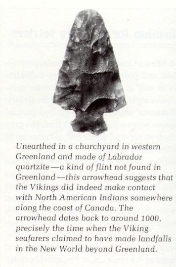
Seventh, Viking artifacts suggesting camping or settlement were found on three spots on Baffin Island, suggesting that it was a land that the Vikings were familiar with southwest of Greenland.

Eight, there is also the issue of what practical difference does identifyinf Helluland make. My larger goal is to find the Vikings' locations from Labrador and farther south. Clearly on his journey when he got blown from Iceland southwestward, Bjarni arrived at a spot from Nova Scotia north to Newfoundland north to Labrador. To me, looking at a map, the choices of Newfoundland (or conceivably Nova Scotia) and Labrador for the first two lands that Bjarni found are so obvious that it's hard to see alternatives for the second land. One couldn't realistically propose for inslance that Bjarni landed at Newfoundland first and then came to Belle Isle as the second land and then sailed to Resolution Island without mentioning Labrador's coastline.

Thanks for talking with me, @Wagonlitz
Baffin island only is an island due to a narrow straight.
Unless you're specifically exploring it you won't see that.
Plus, it's far too large to easily see it's an island. Could be it was that and they guessed it was an island, but it could just as easily be part of the main land like how Norway isn't an island. That too could appear to be an island by your arguments, if reached around Bergen.

Also, just because they were on Baffin later needn't mean they were teh first time.

One of the lead archaeologists at the L'anse aux Meadows site has been B. Wallace, and she laid out her explanation of the site's short span of Viking habitation this way:
She notes it was a matter of years, so needn't be 10 years. Could be just a winter. Though, I don't know how extensive it was. The first quote talks about it being an extensive ground, so if lots of labour was put in, then perhpas it was more permanet than just a single year or two. Or at least intended for longer.

OK, the issue here is whether over time the identities of these three places would remain in the Greenlanders' memories instead of their locations getting forgotten and becoming unreliable during the transmission of the story. So it's not exactly needed that on each trip to Markland the Vikings kept taking the route through all three same spots.
Again, they needn't to have landed at teh same spot every time. There were no roadsigns or anything. If you reach an area looking like Markland then you'd say you'd reached Markaland, even if you reached it say 100 km down the coast from where you usually reach it.
And I don't see why the identities of teh places would becom unreliable over time. I doubt it did.
Like, you could have had them initially reach Resolution island and find it had large, flat rock formations. Later they rech Baffin and finds it has the same. Hence that's also a helleland. As both are close then both are part of teh same land.

even if the Vikings were often illiterate
The vikings weren't more illiterate than the rest of the world.
And honestly, afaik they might even have been a bit more literate in that many knew at least some runes, afaik, but I could be wrong on that. But writing definitely wasn't any kind of unknown thing.

The Sagas also retell poems that the voyagers created, so the implication at least from the Sagas is that the Vikings either had some memorization skills, or else they were able to write down their poems for the Saga writers to record.
Some of those poems if not all of them indeed were from teh 900s/1000s and IIRC were written down. One of the oldest poems is from the early 800s or something like that, and that was written down back then, IIRC.
 
  • 1Like
Reactions:
I'm not sure he really is that unreliable. The sagas have inconsistencies too, e.g. the two we discuss here have differing descriptions of when Erik the Red died. And given the various stories were composed by different people and possibly even at different times, then inconsistencies are to be expected. And it is my impression that he generally is very trustworthy and fit with other sources where they exist. I know it's the case at the very least for the last 50-60 yeras he covers, but it was my impression that also was the case for the earlier parts.
Both Saxo and the Sagas have inconsistencies which makes them unreliable without triangulating the information with other sources. In a way, that's what this entire thread is about.

Yes, you might expect inconsistencies but that doesn't mean you should rely on the information without checking further with other sources. Again, this is what this thread seems to be about.

Saxo is a very important scholar and it is great that he was able to collect the histories he did during that era, transforming oral histories into the written form. But he really needed an editor to help him with not contradicting himself.

"Saxo's history of the Danes was compiled from sources that are of questionable historical value but were to him the only ones extant. He drew on oral tales of the Icelanders, ancient volumes, letters carved on rocks and stone, and the statements of his patron Absalon concerning the history of which the Archbishop had been a part. Saxo's work was not strictly a history or a simple record of old tales, but rather, as Friis-Jensen puts it, "a product of Saxo's own mind and times". Westergaard writes that Saxo combines the history and mythology of the heroic age of Denmark, and reworks it into his own story that exemplifies the past of the Danes.

My analysis of that description is that what Saxo did was blend myths and history into his own stories, which today would be the definition of historical fiction.

Ingvar Andersson's work from the 20th Century that reviews some of Saxo's stories notes how he sometimes tells conflicting stories about the same historical figures in different parts of his works. This could be because Saxo was more interested in getting the different oral histories committed to paper rather than sorting out just what really happened. Or it could be he was more interested in telling good stories rather than historical accuracy.

Apologies if this is too much of a tangent.
 
  • 1Like
Reactions:
Yes, you might expect inconsistencies but that doesn't mean you should rely on the information without checking further with other sources. Again, this is what this thread seems to be about.
Obviously you shuld check other sources. Hope I didn't come across as saying otherwise. What I meant was that if you have parts that only are mentioned in Saxo, then that's not reason to disbelieve them. If it isn't stuff like: And Stærkodder lived for 300 yeras and was as strong as 10 men combined, then it probably should be believed unless there's still contradicting it, exactly because what can be compared to other sources does mostly agree with what's in Saxo.

Saxo is a very important scholar and it is great that he was able to collect the histories he did during that era, transforming oral histories into the written form. But he really needed an editor to help him with not contradicting himself.
Not sure it really is a need of an editor. I think it rather is a desire to keep the different versions, due to him not knowing himself which are more correct. I've always seen it as more a collection of the stories of old, as a leadup to th recent history (which is very reliable, afaik). So more collecting every story he could find, and providing it as it was, before doing what he actually was commissioned to do: Write the history of the Valdemar dynasty.
 
  • 1
  • 1Like
Reactions:
Firstly then Midwinter could be in mid Jan, as winter was mid Oct to mid Apr. I don't know whther it was mid Jan, but my copy specifically states that midsummer was midways through Summer, not when it is today at the solstice. So who knows. Though, it writes that it's when the days are shortest, not Midwinter, and that ight be significant.
Also, look at New Glasgow. It has the Sun rise around a quarter to 8 and set around 16:30. If you only have 8 points you measure time from, then that could be taken to be dagmål and øgt, the two points in question, as that'd be the closest points. Or it could be it'd say it was in between the two.

It says that the Sun stood on the sky at those two points. It's meaningless to say that unless that's when it rose and set. And I can't read it any other way than it'd be sunrise and sunset.
@Wagonlitz !

Tak fordi du snakkede med mig om dette sjove emne! Undskyld hvis det nogle gange er kedeligt eller forvirrende. Men sådan er gåder ofte!
Thank you for talking with me about this fun topic! Sorry if it is tedious or confusing sometimes. But that's how puzzles often are!

The time-measurement issue is significant because it might help to show the location for Leif's camp. My impression was that the literal meaning of the text was that the sun was still standing up in the sky at about 3:30 PM at the shortest time of the year, ie. that the sun had not yet set at 3:30 PM at the winter solstice. So in that case, the text would be giving a northern limit for the location. So one would look for where the sun set at 3:30 PM at the winter solstice, which for the last 400 years has been in early to mid December and hasn't changed more than a few minutes at the solstice. Then, one would conclude that when taken literally, the region for Leif's camp could be someplace within hundreds of miles south of that point.

But I sympathize with what you are saying. it would be more helpful if the text were giving a latittude-type line for Leif's camp and not just a northern limit for it's location.

Helge Kaasin started the Svalbard watch brand, and on its webpage, it proposes an explanation for the Vikings' way of measuring time.
svalbard.watch/pages/about_viking_time.html
German webpage for buying the watches: uhren-sheriff.de/de/?manufacturers_id=34

The webpage gives this table for the Viking times:
eykt_table_500.jpg


The webpage says:
To be able to read off the solar time approximately, the old norse used prominent landscape features on the horizon, as seen from the area of their home or work surroundings. The idea is that the sun should be just above the horizon point in question at the time indicated by the name of the landmark. Thus we have places like Miðmorgunshnjúkur (Mid-morning Peak), Dagmálahóll (Day Mark Hill), and Hádegisskarð (Noon Pass) on Iceland...

Some points on the imagined horizon circle had special names, often connected to meal times. For instance, when the sun was positioned in «landsuðrs ætt» and it was «dagmála staðr», it was time for breakfast, around 08:30. When the sun was positioned in «útsuðrs ætt» and it was «eyktar staðr», it was time for dinner, around 15:30. The exact time indication, the names of the eykts and how they relate to our modern clock is difficult to tell from the saga litterature dating back almost 1000 years. The time intervals used on the Eykt watch is what researchers agree on.
So the webpage is proposing that øgt is from 1:30 PM to 4:30 PM, with the central part of that daymark being at 3 PM. The "Svalbard" brand clock starts the first Eighth Daymark at 22:30 PM, not at 24:00 / 0:00 AM, like modern clocks start their timekeeping for each day.

Further, it's proposing that the Vikings looked for the time at which the sun was just above the skyline, ie. the time right after sunrise and the time right after sunset, for their measurement. So in that case, the Saga is not technically giving the exact time for sunrise and sunset, but the time right after and before them, respectively, when the sun is still visible.
The webpage also proposes that you can use this clock as a compass by checking the sun's position in the sky relative to the points on the clock:
eykt_dial.jpg

This seem at first alittle confusing, because it's counting Eykt as 15:00, whereas the chart on the same webpage counts Eykt as 1:30 PM to 4:30 PM.

The Falcon Banner blog gives a more detailed explanation of Viking time-telling.
falconbanner.gladiusinfractus.com/2019/02/07/scandinavian-time-measurement-during-the-viking-era/

First, it shows the following layout of the horizon, as if you are standing in the middle and have the horizon laying around you for 360 degrees:
farm.gif


Then, you look for this virtual compass direction toward which the sun would rise and set:
dagmark-equinox.gif


As a result, it would seem that if the sun set at the person's southwest, the sun would be setting at "Otta"/Eykt/ øgt, The Eighth Daymark.

Finn Magnusson proposes in his article ON THE ANCIENT SCANDINAVIANS’ DIVISION OF THE TIMES OF THE DAY, that Otta/Eykt/ øgt, the Eighth Daymark, began at 3 PM and ended at 4:30 PM, that is, from the 360 degree clock's mid-point for the Daymark until the End of the Daymark.

Reckoning from this earliest rising time, or the beginning of the morning half past 4 a. m., the eighth stund (or eighth half eikt) elapses precisely at half past 4 in the afternoon, and therefore this period was called, κατ’εξοχην, eykt, the eighth stund (octona) in like manner as every eikt or aliquot part of the day had the same appellation, because it consisted of an eighth part (octava) of a whole natural day. This eighth, eykt, in question commenced strictly speaking at 3 o’clock, and ended at half past 4 p. m., in what was called the eyktar staðr, or the eykt’s place, limit or termination. The precise moment the sun appeared therein indicated the lapse of half the natural day, and was therefore held especially deserving of notice by our forefathers, the more so that, according to their way of reckoning, it also indicated the termination of the day proper and the commencement of the evening. That, excepting during the seasons of harvest {176} and haymaking, the working hours of the free people generally closed at that time, is very probable: but this is quite certain in the case of the holy eves after the introduction of Christianity.

The Old Norse text and Jansson's translation are here:
Meira var þar jafndœgri en á Grœnlandi eða Íslandi;
sól hafði þar [the sun had there] eyktar stað ok dagmála stað um skammdegi [about the shortest days]
(‘Day and night were more equal there than in Greenland or Iceland;
in the depths of winter the sun was in the sky [presumably, set and rose] at around 3 p.m. and 9 a.m.’) (ÍF IV:251).
F. Magnusson's charts count Eykt dags / (Ögt) as 3PM, but Eyktstaðr / Ögterdag as 4:30 PM.

dial_small.png


As to why Eykstadr/Ogterdag refers to 4:30 PM, Magnusson wrote:
[Eyktstaðr] The word signifies the Eikt’s place (here termination or close). It was also called aptan or aptansmál, as the evening commenced here; see above p. 175–178 and notes 26, 27.

[Ogterdag] Also ögterdags beel, ögtebeel. These and several other words which are of great importance in fixing the time of the day now in question, are to be found collected from the Danish and Norwegian Peasant Dialects in the large Danish Dictionary, 4 Vol. 3 Section, p. 17. O.

This gives me the impression that maybe if the Saga writer had said that the sun was up at eykt/ogt, then it might be at 3 PM, but when it says ektar stad, it might mean 4:30 PM.

At least now I feel I have a better handle on what the Saga is talking about.

Wikipedia comments:
This passage states that in the shortest days of midwinter, the sun was still above the horizon at "dagmal" and "eykt", two specific times in the Norse day. Carl Christian Rafn, in the first detailed study of the Norse exploration of the New World, "Antiquitates Americanae" (1837), interpreted these times as equivalent to 7:30 a.m. and 4:30 p.m.
...
An Icelandic law text gives a very specific explanation of "eykt", with reference to Norse navigation techniques. The eight major divisions of the compass were subdivided into three hours each, to make a total of 24, and "eykt" was the end of the second hour of the south-west division. In modern terms this would be 3:30 p.m.

For reference, here are some sunset times at the shortest time of Winter daylight (it's in December) for the range of potential locations:
  • Rigolet, mid-eastern coast of Labrador (this would only work if you count Markland as only a northern section of Labrador): 15:30 / 3:30 PM
  • L'anse aux Meadows (north end of Newfoundland): 16:02 PM (4:02 PM)
  • Channel-Port aux Basques (southwest end of Newfoundland): 16:36
  • Miramichi, New Brunswick (possible area of Leif's camp according to some scholars: Earliest Sunset time in December is 16:34. (4:34 PM)
  • New Glasgow, Nova Scotia (southernmost area on the St. Lawrence Gulf) 16:28 or 16:26 (depending on the website source. I don't understand why it sets earlier in this southern spot)
SOURCES:
timeanddate.com/sun/@6049596?month=12&year=2023
sunrisesunsettime.org/north-america/canada/miramichi-december.htm

The Canadian Dictionary of Biographies comments:
Even the passage in the Saga of the Greenlanders on the length of day in Vinland, which at first sight would seem very helpful, has proved a broken reed. Its interpretation involves highly technical definitions and astronomical calculations, leading to such great diversity of opinion that, on the basis of the passage, Vinland has been located as far north as 58°26´N and as far south as 31°N,

Sigurdsson comments:
Apart from the fact that the text refers to ‘the depths of winter’ (‘skammdegi’) rather than what would have been the more precise ‘solstice’ (‘sólstaða,’ ‘sólhvarf’), there is a problem in precisely how the words ‘eyktarstaðr’ and ‘dagmálastaðr’ should be interpreted; the general sense of these words is the position in the sky where the sun is at eykt (around 3-3:30 p.m.) and dagmál (around 9 a.m.) respectively, but the question arises as to whether the reference is to time or to the position on the horizon where the sun sets and rises. Gustav Storm (1886), with the help of the astronomer Hans Geelmuyden, made a thorough and determined attempt to solve this problem late in the 19th century and came to a conclusion that Leifr’s reading had been made a little to the south of about 50°N, the latitude of northern Newfoundland; this was reckoned to be too far north at the time, when the dominant view was that Vínland lay somewhere in New England, and Storm’s work was largely ignored. Recently the matter has been taken up again by Páll Bergþórsson (2000:161-5). Bergþórsson’s study is marked by attention to detail and an expert knowledge of Icelandic chronological terminology and comes to the conclusion that the observation refers to the direction and position of the sun on the horizon at sunrise and sunset and thus corresponds fairly accurately to the latitude of L’Anse aux Meadows.
But unfortunately, Bergthorsson's work isn't online.

Einar Haugen wrote in his book Voyages to VInland:
A passage in the Edda of Snorri Sturluson has been less considered, but seems much more pertinent. It states that the sun sets at "eyktarstad" at the beginning of winter (probably about October 14 in Iceland). This brings out the real bearing of the passage and the only meaning that makes sense from mariners without sextant or compass. They were simply trying to express how much longer the day was in this region than at home, for just imagine! here the sun was as high in the dead of winter as in Iceland at the beginning of winter. It is no precise observation, but rather a general comparison which suggests that they were a goodly distance from home*
For reference, sunset is at 4:12 PM on October 14 in Reykjavik, Iceland.

In conclusion, based on F. Magnusson's work and, my sense is that "eyktar stað" in the Saga could mean 4:30 PM like Magnusson considers "Eyktstaðr" to mean in contrast to "Eykt". But I am not sure if the Saga's phrase "Eyktar stað" is a way of meaning that the sun is standing at the eighth daymark, ie. 3 PM. Plus, 4:02 PM to 4:34 PM looks like the possible real-world range for what the time would be for the range of possible locations for Leif's camp, so it seems that "eyktar stað" would have to be 4 PM, ~4:30 PM, or somewhere in between.

So this is a tough issue for me, and I checked a lot of materials.
 
Last edited:
Translation does need to take idioms into account. It should also take into account nuance about the meaning of words. Literal translations can be bad ideas.

About Saxo, I think it's somewhat complicated. I've heard that the legends/myths of the Danes were from Books 1-9, and Books 10-16 were mostly accurate history. That being said, legends can include historical truth, so... He does contradict the sagas on mythological details (Baldr, Ragnar Lodbrok, etc.), but a) he was euhemerizing (although Snorri did that too), and b) there is at least one other source about Ragnar that contradicts both of those accounts.
 
  • 1
  • 1Like
Reactions:
Not sure it really is a need of an editor. I think it rather is a desire to keep the different versions, due to him not knowing himself which are more correct. I've always seen it as more a collection of the stories of old, as a leadup to th recent history (which is very reliable, afaik). So more collecting every story he could find, and providing it as it was, before doing what he actually was commissioned to do: Write the history of the Valdemar dynasty.
Thanks for the clarifications @Wagonlitz . Yes, I agree there is some use to keeping different stories and different perspectives. But it can be confusing and an editor might have helped frame it or organize it in a better way.

You are absolutely correct about Saxo's later material. Most scholars agree that as Saxo wrote material that was closer to his time period his accuracy improved. Of course, you have a cultural perspective to approach this that I'm missing.
About Saxo, I think it's somewhat complicated. I've heard that the legends/myths of the Danes were from Books 1-9, and Books 10-16 were mostly accurate history. That being said, legends can include historical truth, so... He does contradict the sagas on mythological details (Baldr, Ragnar Lodbrok, etc.), but a) he was euhemerizing (although Snorri did that too), and b) there is at least one other source about Ragnar that contradicts both of those accounts.
Absolutely. Thanks for summing this up better than I could @HistoryDude .
And let's not get started on Ragnar who has so many different versions floating about in both history and fiction.... I think that's why he's considered a semi-mythical figure. (Definitely part of history but which parts are correct?)
 
  • 1Like
Reactions:
"A second reason is the description of Helluland as being a flat rock land with glaciers instead of trees or grass. Some parts of Baffin Island have grass, but other parts don't and compared to Labrador, it's basically treeless. The description is a pretty good fit."

It specifically says large, flat rocks. That doesn't fit with grass, and I don't see any mention of grass and in fact that land is listed as worthlss, whihc grasslands wouldn't be.
OK. To be clear, there are three visits to a "Helluland" in the Sagas, on all three trips, they see flat rocks and glaciers.

The first time, Bjarni lands on his Third Land. When Leif lands on that Land later, they don't see grass "there," meaning perhaps just that there was no grass in spots. This matches at least how in some major spots in Baffin Island there are regions with no grass.

Then in Eric the Red's Saga, they see foxes and name a land Helluland. Since there are foxes, it seems that there would be grass on at least some part of Helluland. The typical idea is that the same land is called "Helluland" in both Sagas, but from what you said about Kjalarnes, I expect that you might think that they can just as easily be different real world lands in the case of "Helluland."

In any case, here are the descriptions of the three landings, starting with Greenlanders' Saga's two landings, and then the two versions of the landing in Eric the Red's Saga (Jansson's translation):

He told them to raise the sail, and this was done, and they turned the prow away from land and sailed out to sea on a southwesterly wind for three days and then saw a third land. This land was high and mountainous, with a glacier on it.
They then ask if Bjarni wanted to make for land here but he said he didn’t want to, ‘because this land doesn’t look to me likely to be of any use.’
This time they did not take down the sail and keep along the coast and saw that this was an island.
...
Now they fitted out their ship and sailed out to sea when they were ready, and came first to the land that Bjarni and his men had found last. There they sail up to the land and drop the anchors and lowered a boat and went ashore and saw no grass there. Higher up it was all great glaciers, and as if it were all a single slab of flat rock right the way to the glaciers from the sea, and the land seemed to them devoid of any qualities.
Then Leifr said: ‘Things have turned out differently with this land for us than for Bjarni, not setting foot on it. Now I will give the land a name and call it Helluland.’

þa funndv þeir lannd ok rero firir . a baatvmok kavnnavdu lanndit ok funndv þar hellr margar ok svo storar at tveir menn mattu vel spyrnazt i iliar.
(Then they found land and rowed along it in boats and explored the land and found many flat rocks there so big that two men might well lie end to end [on one].)
þa sa þeir land ok skvtv bati ok konvðv landit ok fvnnv þar hellvr storar ok margar . xij. allna viðar
(Then they saw land and launched a boat and explored the land and found many big flat rocks there, twelve ells wide [about six meters].)
melrackar voru þar margir
(There were many foxes there.)
fiollði var þar melracka
(There were a great number of foxes there.)
þeir gafv naf lanndinv ok kavllvdv hellv. lannd.
(They gave the land a name and called it Helluland.)
þeir gafv þar nafn ok kollvðv hellvland
(They gave the place a name and called it Helluland.)
The time when the Vikings see no grass on Helluland is when they travel west across the sea from Greenland in the Greenlanders' Saga. In real life, the closest part of Baffin Island to Greenland is the east end of Baffin Island, like Cape Dyer. Here is a photo of Cape Dyer:
upper-base-cape-dyer-6.jpg

Here is another photo, with no grass:

But I was also able to find photos of the region of Cape Dyer that had some kind of brown grass (like below), not really the healthy stuff like in Newfoundland.
Also, again, yuo're thinking about this from a modern POV. Yes, the minimum distance from Resolution to Labrador might be long, but if they're going at sea and coming into the coast far down Labrador then the minimum distance doesn't matter.
They dint' have the geographical knowledge you do and wouldn't necessarily have taken the shortest routes.
Also remember that a day is only 12 hours, not 24. And the distance covering you have kept quoting, does that take that into account?
To be clear, the minimum distance from Resolution to Labrador would be far shorter than one would expect for the 3 doeger journey, even if we count the 3 doeger as 3 12 hour periods as you've been reasonably explaining. This is because the average ship speed was 7 mph, and in 36 hours total, the ships would reach 252 miles, whereas the distance to Resolution Island from Labrador is ~40 miles. If they were going up Labrador, then left Labrador at the northernmost point on the Atlantic side (near Killiniq), they would go directly north and hit Resolution Island at ~40 miles.

You are suggesting in your second sentence above that maybe the Labrador end of their journey was at some point farther south down the coast of Labrador, so that this minimum distance doesn't matter. But remember that the Saga says that they were taking a northeast direction (southwest wind), and if you leave Labrador in a northeast direction from farther south than the northernmost point of Labrador's Atlantic side, you won't end up at Resolution Island or at any spot by Baffin Island, but instead will end up crossing the ocean straight to Greenland without hitting any island in between.
What does: "The man placed the wooden shoes" mean?
What does it mean if you shoot the parrot?
You said you want literal translations, so what does the two above things mean? And no Googling or in other ways looking anything up.
It sounds like you are asking me to explain the meaning of these two sentences, or else translate them into another language like Danish or Old Norse. However, for me to explain the meaning in either case, I would not be making a literal translation into another language that I knew in order to test the worth of literal vs. "general sense" type translations.

Anyway, typically with multiple translations you get some that are more precise and literal and others that are more approximate and can vary wildly as to how close they capture the actual sense of the text. I find it's always helpful when there are footnotes like your book version has.

I don't know about Danish, but in English we have dozens of English translations of the Bible and this kind of literal vs. general sense debate is a big deal even up through today. So when someone says that literal translations are better or worse than general sense translations, they are talking about relative qualities and making a subjective judgment. So let me say that although one could translate a text in an overly literal way that hurts the translation quality, I tend to prefer the more literal, precise translations out of all the major translations of the Bible.

Specifically, I found that the KJV and NET translations repeatedly and typically presented the most exact, precise translation of the Biblical texts, and I prefer them for that reason.

Now, when translating you should stay true to the source, of course, but in some cases you will need to also use stuff that makes sense to the readers. Whihc is why a good translation, like mine, will have an explanation a the back for words/terms whihc can't really be translated without an explanation as well as using footnotes.

Also, translating Old Norse to Danish presumably also is easier than going Old Norse to English, as a lot still is the same in Danish. So ythere'll be stuff that you don't ned ot explain, whereas in English you'll miss stuff. Like, in one of the quotes you gave I could see that the Old Norse talked about a fjord, but the English translation said bay...
+1
One of the difficult parts about online conversations is that people often end up talking more about things that they disagree about than things that they agree about, so that their conversation can give a wrong impression like they have the opposite POV in general.

We are covering a lot of ground here.


  • (A) Bjarni's boat was overall sailing southwest from Iceland, and then when it got to the First Land, he sailed with the land on his left side, ie. northward toward Greenland and Counterclockwise around the First Land.
    (B) For Bjarni to sail from central eastern Nova Scotia to Newfoundland, he would have to tack north and east against the wind, or else wait for the wind to change into a helpful direction. Supposing that he sailed north along N. Scotia until he got to the north end of Cape Breton, he would also have to sail northeast to get to NFLD. ~Rakovsky

Where does it say that? It just says that the wind is northern. It could do in any direction, in fact, calling it a northern wind suggests it's primarily southern. So for all we know they culd ahve been blown so far south that going due west on a latitude would hit NS, not NF.
No wind direction is given between first and second land. Also, note, its possible they kept being abl to see the first land for a good amount of time while at sea towards the second land.
(A) is pretty straightforward from the Greenlanders' Saga. Here is the passage starting from where they put out to sea. Note that a "north" wind means a wind pushing in a southward direction (ie. toward the south), and that when it says that they are sailing with the land on their "larboard" or "port side," it means that it's on their left side:
However, they put to sea so soon as they were ready and sailed for three days, until the land was out of sight under thewater; but then the fair wind fell, and there arose north winds and fogs, and they knew not where they were, and thus it continued for many days. After that saw they the sun again, and could discover the sky; they now made sail, and sailed for that day, before they saw land, and counselled with each other about what land that could be, and Bjarne said that hethought it could not be Greenland. They asked whether he wished to sail to this land or not. "My advice is," said he, "to sail close to the land;" and so they did, and soon saw that the land was without mountains, and covered with wood, andhad small heights. Then left they the land or their larboard side, and let the stern turn from the land.
As for (B), this is my explanation based on known geography. Here is a map of the St. Lawrence Gulf:
50292XL__76843.1642739001.1280.1280.jpg

To get from Nova Scotia to Newfoundland based on the map, you have to practically go in a northward or northeastward direction. So either the wind mentioned in the quote above that drove Bjarni toward his First Land is still blowing southward to Nova Scotia, and in that case Bjarni is stuck trying to sail pretty much against it, or else the wind changed course, which is not mentioned in the text.

You are right that no wind direction is mentioned in the text from the first to second land, but it also says that the boat has the land on its port side while the boat is going along the first land, and no mention is made either of a direction change of the ship viz a viz the land's side, eg. it never says that the boat turned with its back end (stern) to the land, like when it talks about Bjarni's other Landmass travels. So you can guess reasonably that the boat kept sailing in the same direction as it went from the First Land to the Second Land. But in that case, a trip from Newfoundland to Labrador sounds better than a trip from Nova Scotia northward to another land, because when you travel along Newfoundland's northeast coast, you can keep the land on your port side all the way probably until you get within view of Labrador, since Labrador is only 10.8-20 miles from Newfoundland.

Anyway, Baffin isn't North East of Labrador.
It can be tricky, but for the sake of clarity, if you look at a map showing the longitudinal lines, you can see that Cape Dyer on the east end of Baffin Island is to the northeast of Killineq on the top north end of Labrador's Atlantic coast:

You can see what I mean alittle bit better on this map because Cape Dyer is marked in red:

  • Another difficulty is the description of the three lands. Supposing that N. Scotia was the first, wooded land with small hills, and Newfoundland was the second, flat land with woods, this description doesn't seem to match the two lands. Nova Scotia seems flatter than Newfoundland. The top end of Cape Breton is hilly, but Newfoundland is even hillier. Further, if N. Scotia and NFLD were the first two lands, then Labrador would be the third land, yet Labrador doesn't match the description of Helluland as a treeless glaciered land.

What does NS in generally being flatter matter here? Like, they're not exploring the lands. They're lietrally hitting the coast in a single place and perhalf going up it for a bit. And if the NF hills are mostly inland then they'd be unablt to see them.
Iceland is called iceland because it initially was reached tat teh north eastern part which had big glaciers. Yet, Iceland for the most part doesn't have glaciers. Where you randomly land matters, and they could have landed anywhere on teh coastline.
Right. So if the Vikings sailed from Iceland to Nova Scotia, they would naturally mostly likely have been hitting someplace on N.S.'s east coast from Halifax to Wreck Point (the northeasternmost cape), if you look at a map of what part of N.S. gives the most face toward the Atlantic Ocean. In contrast, if the Vikings landed from Iceland onto Newfoundland, they would have hit its northeast-facing coast. Here is a map with two potential routes southwest from Iceland:
Basic North Atlantic current map.jpg

Next, if you use a topographical map, like ACME Mapper or Google's topographical view, you can check the map for hills, ie. both for elevation height and for changes in elevation height by each of these two potential landing coastlines. You can also check photos of these coasts online and check the statellite view. Based on all of these visuals and map information with hill height data in meters topographically shown, Newfoundland's northeast coast looks more hilly than Nova Scotia's, which looks relatively flat over long distances.

Bear isles (Bjarneyjar) most likely is an island group off the coast of America. If we trust the name form in the second edition of the saga, Bear Island (Bjarney) then it coiuld be the island Disko off the coast of Greenland far tot eh north. ...
That'd be ploral, but the other edition has it in singular, bjarney, s they differ ther. And it's an easy mistake to make either way, so could be island to isles or isles to island. Each is trivial to make when transcribing.
↑ OK, Wagonlitz, thanks for quoting the Footnote. ↑
I see what you mean. The Skalholtsbok says Bear Islands, the Hauksbok version says Bear Island.

  • ...choice of Resolution Island would force the sailing journey to Helluland from Labrador to be even shorter than we read in the Sagas and the journey to Greenland to be even far longer than a shorter journey from Baffin Island's easternmost point.

How so? They needn't have taken teh shrtest route. And who says they crossed up at Baffin's easternmost point?
OK. The overall problem that I am raising is that it doesn't look feasible to posit a route to a place besides Baffin Island that meets all these requirements of the text like:
  • (A) a northeast route from Markland to Helluland and northeast again to Greenland
  • (B) a 3 to 4 day ratio of the journey between those three landmasses
  • (C) a route that would at least somewhat resemble the range of known Viking sailing times, like 7 to 11 mph at 12 hours per doeger
  • (D) the description about flat stones and glaciers for the landmass.
So for instance, 1. You can plot a line northeastward from Labrador to Resolution Island, if you start the line at the southernmost, bottom end of the Ungava Bay, which is at the top of the map below. But that doesn't look feasible as a departure place that they would use for a journey northeast to Greenland, as they would basically be sailing back northward along the Labrador coast again.
https://geology.com/canada/newfoundland-and-labrador-map.gif

Alternately, you can plot a longer, 3 day route departing from a point southeast along Labrador's east, Atlantic coast, ie. farther southeast of Killineq, so that you would reach a normal 3 day journey of over 100 miles to get to Resolution City. But such a journey would be in a bit of a northwest direction, and in fact the farther southeast that you go on the Labrador Atlantic coast to make your departure point to Resolution Island, the more northwest your trajectory would have to be.

I could go on, but in that case, it might be more helpful if you showed a potential island that you think might be Helluland, because when I get to actually picking something on a real world map, the coordinates in the Sagas basically force me to pick someplace with flat rocks and glaciers like Baffin Island that is rather midway northeast of Labrador and southwest of Greenland. And there's basically no other real world candidate for that sitting between Labrador and Greenland, except for Baffin Island. At most I guess they could ahve found some little island right off the coast of Baffin Island, but in that case I would have imagined that they would have made reference to the giant Baffin Island itself.


I agree with alot of other points that you made in your posts.

Here is the Viking cartoon from US newspapers that I was talking about in Danish:
41bfd937-9dc5-4233-b37d-8b0398b9a836.jpeg
s-l1600.jpg
 
@Wagonlitz and @Barsoom ,
Thanks for your contributions.

We have a solid handle on Brattahlid's and Vestribygd's (Western Settlement) locations.
map.jpeg


9-greenland-eriks-fjord-brattahlid-david-noyes.jpg

Brattahlid

Maps of remains of sites in the Western Settlement :
The-Western-Settlement-of-Norse-Greenland-The-principal-church-farm-lies-at-Kilaersavik.png


350px-Western-settlement-eng.png


Arrowhead from Labrador found in Graveyard in Western Settlement:
arrow2.jpg

Article on the arrowhead: http://www.geocities.ws/netnoaide/oldno.html

Going from Greenland to Hop, where things become uncertain is Bjarneyar (Bjarney Islands). I get a pretty strong sense that it's referring to islands on the coast of Greenland north of Nuuk.

Here is the quote in Eric the Red's Saga about the Bjarneyar:
SkálholtsbókHauksbók
a. skipvm þeira var fiorvtiggi manna annars hundrads. sigldv þeir vnndan sidan til uestri bygdar ok til biarmeyia.
(On their ships there were 160 people. Then they sailed on to the Western Settlement [of Greenland] and to the Bjarney Islands.)
þeir hofþv allz .xl. manna ok .c. er þeir sigldv til vestri bygðar ok þaðan til bianeyiar
(They had altogether 160 people when they sailed to the Western Settlement and from there to Bjarney Island.)
sigldu þeir þadan unndan biarneyium nordan uedr . uorv þeir uti tuau dægr
(From there they sailed by the Bjarney Islands on a northerly wind. They were at sea for two days (dgr).)
þaðan siglðv þeir .íj. dœgr i svðr
(From there they sailed south for two days (dgr).)
þa funndv þeir lannd ok rero firir . a baatvm ok kavnnavdu lanndit ok funndv þar hellr margar ok svo storar at tveir menn mattu vel spyrnazt i iliar.
(Then they found land and rowed along it in boats and explored the land and found many flat rocks there so big that two men might well lie end to end [on one].)
þa sa þeir land ok skvtv bati ok konvðv landit ok fvnnv þar hellvr storar ok margar . xij. allna viðar
(Then they saw land and launched a boat and explored the land and found many big flat rocks there, twelve ells wide [about six meters].)
melrackar voru þar margir
(There were many foxes there.)
fiollði var þar melracka
(There were a great number of foxes there.)
þeir gafv naf lanndinv ok kavllvdv hellv. lannd.
(They gave the land a name and called it Helluland.)
þeir gafv þar nafn ok kollvðv hellvland
(They gave the place a name and called it Helluland.)

If you just take this sentence on its own literally, then it's very unclear where the Bjarneyar are, like if they are on the coast of Greenland or across the sea in Canada's region: "They had altogether 160 people when they sailed to the Western Settlement and from there to Bjarney Island."

At face value, the passage just says that they sailed from the Western Settlement to Bjarneyar and then south for 2 days to Helluland, which can help you estimate the direction and distance from Bjarneyar to Helluland.

However, other information in the two Sagas and outside the Sagas can help us make guesses of where Bjarneyar was. For instance, you wrote earlier:
As you quoted earlier then they only give time at sea for when they're on open sea, so sailing along the coast could be whatever time.
I don't know if that's an iron rule, but the statement above does seem at least to be a trend, so it's at least a hint that probably the Bjarneyar are on Greenland's coast. The more hints that we have about Bjarneyar's location, the more solid and probable a guess that we can make about it becpmes.

There is also the curious coincidence that there actually are a collection of islands on Greenland's east coast known today formally as the Bear Islands ("Bjorne islands" in Danish), and they are almost directly east of the Disko Island area. (https://en.wikipedia.org/wiki/Bjorne_Islands) Conceivably this naming could be an echo of an oral tradition alluding to the location in the Saga. In the case of the modern islands with the formal name "Bear Islands" on Greenland, the leading naming factor was that a polar bear was killed there.

Based on our discussions already in this thread, do you think we have a solid handle at this point that Bjarneyar is Disko Island or a chain of islands on Greenland's coast north of Nuuk?
 
Last edited:
John English posted the following conversation that he had with the archaeologist B. Wallace connecting the butternuts found at the Viking site in L'anse aux Meadows with the Miramichi River area:
My[the author]suggestion that these nuts come from Miramichi is in turn based on the following reasoning:
Northeastern New Brunswick is the area of butternut growth closest to L’Anse aux Meadows (hereafter LAM). Their soil and season requirements mean that they have never grown in Newfoundland. Nor do they seem native to Nova Scotia, Prince Edward Island, or northern Maine. Also, the northeastern limit of butternuts corresponds to that of wild grapes. The butternuts would ripen at about the same time as the grapes, so the men who brought butternuts to LAM would likely have seen the grapes there too. This would be the source for the name Vinland. ... The distance to other possible locations is considerably longer. Other possibilities are the area just east of Quebec City and New England south of New Hampshire, but these are considerably farther from LAM*.

SOURCE: facebook.com/beaubearsisland/posts/pfbid0QNjVxVbKdhnJjaLvxLJJ6s7aermsdrHAiKKnXUvk1Mj3EA7s34qTrHMqDrg7Puxul?__cft__[0]=AZVyYN30N3lkVy4IvJZOH_HN5LYAcLQb1sJduDfCDFZ7kwg-hcRowHp55XRECahrzhRg4LhqsRwEZjqr85qEUor4HUtSa1UKlSoZ-xLwE41uvk-i_ze2SSPEfnqlFq-RaBtuXR_WP1QYPl857nmQEmca8Ws3f_v-19bl7M4yWOXElfpJfmnp7fE227d7ZIHXilQ&__tn__=%2CO%2CP-R
 
Just came across this piece about a new book that should be out in November about the Norse in America. Thought some folks who read this thread might have an interest.
 
  • 1Like
Reactions:
Just came across this piece about a new book that should be out in November about the Norse in America. Thought some folks who read this thread might have an interest.
About a month ago, I corresponded a bit with the author, M. Whittock about the kind of directional/locational issues that we are getting into in this thread.

His upcoming book's focuses include the way in which the Viking story about Vinland has a certain following historically among some US Americans who in a nationalistic vein wanted to see themselves in America as being part of a Germanic tradition centuries old in the country. I noted in my writing to him that American history in the purely sociopolitical sense only seems to begin with the English Crown's late 15th century explorations into eastern Canada and directed down the US Atlantic coast, as well as with the possible Bristol fishermen's voyages of the 1480's to eastern Canada, or even as late as the 1585 Roanoke colony and 1607 Jamestown colony. So perhaps in a way, when contrasted with European history that goes back to ancient and medieval times, from a hyper-nationalistic POV, the US has an inadequacy in terms of the length of its history.
 
Last edited:
  • 1Like
Reactions:
Just came across this piece about a new book that should be out in November about the Norse in America. Thought some folks who read this thread might have an interest.
Looks like a hack job, frankly.
 
  • 1Like
Reactions:
Here's a source on Norse food and drink. Others here will no doubt critique the quality of this source but there are a variety of articles online that seem to say the same thing: the Norse made fruit wines from cherries and apples.
Here's another source that discusses the finding of grape pips from the Viking Age and earlier in Denmark. However, it seems there's quite a bit of extrapolation in their analysis regarding the possibility that the Norse regularly used grapes to make wine, at least in Denmark.
 
  • 1Like
Reactions:
Vinland = Wine land because there were grapes? Did the vikings make wine? Their home seems too cold for it.
They drank wine. For them to name a land after the grape, it's quite enough that they knew wine was made from it and tasted good.
 
  • 1Like
Reactions:
Vinland = Wine land because there were grapes? Did the vikings make wine? Their home seems too cold for it.
Right. The short answer is "Yes" to all of what you just asked and asserted.

The 11th century scholar Adam of Bremen described that the King of Denmark explained it to him this way:
He also told me that many in this part of the Ocean have discovered an island called Vinland because there are grapevines growing wild which produces the best of wines. From trustworthy Danes rather than from fantastic tales, I also have heard that there is an abundance of cereal which is self-sown. Beyond this island, he [King Sven of Denmark] says, are no more inhabitable islands in the Ocean. Everything farther out is covered by immense masses of ice and perennial fog. Martianus tells of this:’ One day of sailing beyond Thule the sea is solid.’ This the widely travelled King Harold of Norway found to be true.
The story of finding grapes and naming of Vinland after the grapes comes up in the Greenlanders' Saga, and the finding of grapes is also in Eric the Red's Saga.

The Vikings made sweet fruit alcoholic drinks, one of the most famous being Mead, their homelands in Scandinavia are generally too cold for grapes, except for occasional wine growing in Denmark.

Eastern Canada and the northeast USA have major native grape populations like Concord Grapes used by American winemakers today for winemaking.
Wine-vit-rootstocks.jpg

There is a pretty solid scholarly consensus that Vinland refers to a place south of the Labrador Peninsula, with two of the most common theories for Vinland's location being Newfoundland (like where L'anse aux Meadows Viking settlement remains were found) and New Brunswick (the northeast end of the range where butternuts grow wildly).
 
  • 2
Reactions:
They drank wine. For them to name a land after the grape, it's quite enough that they knew wine was made from it and tasted good.
Indeed, they drank wine and knew of it from their wide travels. However, if they regularly made wine from grapes in their homelands is still up for some debate. Various sources (some already cited in this thread) say wine from grapes was regarded as a luxury by the Norse, and not always readily available.
 
  • 2Like
Reactions:
Indeed, they drank wine and knew of it from their wide travels. However, if they regularly made wine from grapes in their homelands is still up for some debate. Various sources (some already cited in this thread) say wine from grapes was regarded as a luxury by the Norse, and not always readily available.
Whether they made wine in Scandinavia is interesting for Scandinavian history or the long term view of global warming, but it's pretty much irrelevant to the question of how they got to name Vinland.
 
  • 1Like
Reactions:
Indeed, they drank wine and knew of it from their wide travels. However, if they regularly made wine from grapes in their homelands is still up for some debate. Various sources (some already cited in this thread) say wine from grapes was regarded as a luxury by the Norse, and not always readily available.
I'm going to guess that wine from grapes wasn't a normal thing made in Norway, Iceland, or Sweden, and the main homeland for the Vinland explorers was Norway-Iceland. But there was enough contact with Germany and places farther south for them to know about actual grapes.

One factor in their familiarity with grapes was that they were part of the Christian Church in the centuries before the Reformation and 1054 Great Schism, and the topic of Christianity comes up a lot in the two Sagas on Vinland. Gudrid is aone of the lead characters in these Sagas and she made a pilgrimage to Rome. Greenland had a bishop in the 11th-12th century appointed by Rome too, and a medieval bishop's remains were found in a crypt in Greenland. One of the key elements that Communion would use was actual grape wine, and if wine for communion was made from anything else than grapes, it would be an unusual exception. If grape wine was in low supply, then clergy used work-arounds like keeping raisins to mix with water or keeping grape wine but then diluting the wine with water.
(See also: https://history.stackexchange.com/q...n-iceland-require-the-import-of-wine-for-litu )
 
Last edited:
  • 1
Reactions:
Whether they made wine in Scandinavia is interesting for Scandinavian history or the long term view of global warming, but it's pretty much irrelevant to the question of how they got to name Vinland.
Before the 1960 discovery of the L'anse aux Meadows site, there was more uncertainty of whether the Vikings actually got south of Labrador or whether the Vinland Sagas were basically myths like Beowulf. In that time before the discovery, there was more speculation as to whether the Vikings actually found real grapes or if they were just talking about some berries that they sloppily grouped together with real grapes under the name vinberries/wineberries. Now with the butternuts' discovery at L'anse aux Meadows, it's clear that they were harvesting at spots with actual grapes.
 
  • 1
Reactions: