Hello everyone, and welcome to the fifth Tinto Maps! This week we will be sharing the map of Italy.
One comment before we start: we know that you might be eager to discuss other regions that may appear partially on the DD, such as the Balkans. Let’s try to keep the conversations separated in different threads, please; every region will get its own Tinto Maps, and we will show them and gather feedback in due time, in their own DD.
With that said, let’s start!:
Countries

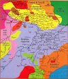
The situation of Italy in 1337 is quite interesting. The main power in the peninsula is the Kingdom of Naples, ruled by King Robert I, who is also ruler of Provence, and a few minor countries in Northern Italy; his efforts towards the domination of Italy also made him the leader of the Guelph faction in Italy, which backs the Pope. Speaking of him, the seat of the Curia is at Avignon, and regaining control over the Papal States and moving it back to Rome might take some time and effort. Opposite to all of them, there is the Ghibelline faction, led by the Signoria of Milan, ruled by the Visconti dynasty. They are backed by other important powers in the Italian region, such as the Superb Republic of Genoa, or the Duchy of Verona, ruled by the dynasty of della Scala. There are also neutral powers, like the Republics of Venice or Siena, although they could be attracted to join one of the factions. And we also have foreign powers that have already set a foothold in Italy, such as the Crown of Aragon, which has established a branch of its dynasty as Kings of Sicilia, while also recently conquering some lands in Sardinia.


Guelphs and Ghibellines factions! They are International Organizations part of a Situation.
Dynasties

Locations

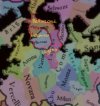
There is an interesting density in Italy, especially in the North, where there are plenty of communes - the Italian city-states. You might also notice something a bit different from previous Paradox GSGs: Venice is not an island, but the location has lands around the lagoon. We aren’t 100% sure that this will be the final design, as we have a few ideas to try to keep its special position on an island inside the lagoon while addressing the issue of it being too small to appear in the map; in this regard, we’re open about feedback and ideas on the topic.
Provinces

Any naming suggestions about the provinces are well-received, as usual.
Terrain


Three usual terrain layers. Something that I want to comment on is that we’ve been following this thread about ‘Revising Flatlands and hills’, and we are trying to get a bit more granularity in the Topographical map with the help of @SulphurAeron .
Cultures

Italy is also a region with a sharp cultural division, and also plenty of minorities; although they don’t appear on the map, there are Italki Jews, or Greek and Albanian people in the South, among others.
Religions

Another boring region, with more than 90% of the population being Catholic, with most of the religious minorities being Italkim Jews and Orthodox Greeks. We're considering implementing Waldensians, although adding more diverging Catholic heresies/confessions is a bit of a low priority for us right now. As a side note, it might catch your eye the Krstjani of Bosnia; we’ll discuss them later on, in the Tinto Maps devoted to the Balkans.
Raw Goods

Italy is a rich region with plenty of interesting raw materials.
Markets

There are three market centers in Italy: Genoa, Venice, and Naples (which was a very, very rich country in 1337, the wealthiest of the region). As usual, take into account that. 1. We don't script in the setup which locations belong to each market, they're automatically assigned to each market. 2. This starting distribution is not final, and it might change, as we do tweaks to the market access calculations over time.
Population


There is around 10.5M population in the Italian region as of now. Taking into account how divided the political landscape is, Naples looks scary…
And that’s all for this week! For the next one, we will be talking about the British Isles, with @SaintDaveUK . See you!
One comment before we start: we know that you might be eager to discuss other regions that may appear partially on the DD, such as the Balkans. Let’s try to keep the conversations separated in different threads, please; every region will get its own Tinto Maps, and we will show them and gather feedback in due time, in their own DD.
With that said, let’s start!:
Countries
The situation of Italy in 1337 is quite interesting. The main power in the peninsula is the Kingdom of Naples, ruled by King Robert I, who is also ruler of Provence, and a few minor countries in Northern Italy; his efforts towards the domination of Italy also made him the leader of the Guelph faction in Italy, which backs the Pope. Speaking of him, the seat of the Curia is at Avignon, and regaining control over the Papal States and moving it back to Rome might take some time and effort. Opposite to all of them, there is the Ghibelline faction, led by the Signoria of Milan, ruled by the Visconti dynasty. They are backed by other important powers in the Italian region, such as the Superb Republic of Genoa, or the Duchy of Verona, ruled by the dynasty of della Scala. There are also neutral powers, like the Republics of Venice or Siena, although they could be attracted to join one of the factions. And we also have foreign powers that have already set a foothold in Italy, such as the Crown of Aragon, which has established a branch of its dynasty as Kings of Sicilia, while also recently conquering some lands in Sardinia.
Guelphs and Ghibellines factions! They are International Organizations part of a Situation.
Dynasties
Locations
There is an interesting density in Italy, especially in the North, where there are plenty of communes - the Italian city-states. You might also notice something a bit different from previous Paradox GSGs: Venice is not an island, but the location has lands around the lagoon. We aren’t 100% sure that this will be the final design, as we have a few ideas to try to keep its special position on an island inside the lagoon while addressing the issue of it being too small to appear in the map; in this regard, we’re open about feedback and ideas on the topic.
Provinces
Any naming suggestions about the provinces are well-received, as usual.
Terrain
Three usual terrain layers. Something that I want to comment on is that we’ve been following this thread about ‘Revising Flatlands and hills’, and we are trying to get a bit more granularity in the Topographical map with the help of @SulphurAeron .
Cultures
Italy is also a region with a sharp cultural division, and also plenty of minorities; although they don’t appear on the map, there are Italki Jews, or Greek and Albanian people in the South, among others.
Religions
Another boring region, with more than 90% of the population being Catholic, with most of the religious minorities being Italkim Jews and Orthodox Greeks. We're considering implementing Waldensians, although adding more diverging Catholic heresies/confessions is a bit of a low priority for us right now. As a side note, it might catch your eye the Krstjani of Bosnia; we’ll discuss them later on, in the Tinto Maps devoted to the Balkans.
Raw Goods
Italy is a rich region with plenty of interesting raw materials.
Markets
There are three market centers in Italy: Genoa, Venice, and Naples (which was a very, very rich country in 1337, the wealthiest of the region). As usual, take into account that. 1. We don't script in the setup which locations belong to each market, they're automatically assigned to each market. 2. This starting distribution is not final, and it might change, as we do tweaks to the market access calculations over time.
Population
There is around 10.5M population in the Italian region as of now. Taking into account how divided the political landscape is, Naples looks scary…
And that’s all for this week! For the next one, we will be talking about the British Isles, with @SaintDaveUK . See you!