

The sources on Bengali vegetation are quite primitive, and I'm having to refer to some very anachronistic sources (both the pre-mughal Sultanat inscriptions, Mughal era Ain and Tabiqat and the post Mughal Riyas) for the barest of breadcrumbs of information - meaning what I post might as well be completely inaccurate beyond the broad strokes.
India in Project Caesar
- Thread starter PerhapsItsChondoLal
- Start date
-
We have updated our Community Code of Conduct. Please read through the new rules for the forum that are an integral part of Paradox Interactive’s User Agreement.
You are using an out of date browser. It may not display this or other websites correctly.
You should upgrade or use an alternative browser.
You should upgrade or use an alternative browser.
I'd disagree that religion is a bigger factor than culture when it comes to interpersonal interactions, though - at the POP level at least.Yeah, though you were more right, in that religion is (usually) a bigger factor, unless it's two very distinct cultures like Awadhi and Bengali or Marathi and Tamil, for example. You won't have many differences between Awadhi and Bhojpuri, certainly.
Read a paper a few months ago that convinced me on the theory that at a village level the Hindu-Muslim divide was only cemented in the nineteenth century. At the level of state of course there were differences. However one must note that Hindus were employed in the imperial bureaucracy, and imperial powers often allied with and as a result elevated certain Hindu groups (Rajputs, Marathas and Jats being obvious examples). That's actually my personal theory as to why parts of India were barely converted after centuries of Muslim rule. Anyways, I'm not really trying to speak on place names on the issue, just on the matter of spurious reasoning that would result in Hindu and Muslim pops being antagonistic to one another (below state level) to the extent of today.
Probably true, but we were talking about location namesI'd disagree that religion is a bigger factor than culture when it comes to interpersonal interactions, though - at the POP level at least.

- 1

These are (most) of the Bengali mint towns, mapped out though not all numbered - then I'll try to use other sources to fill in the rest
Provinces might be too small - though at the same time it's not even half of the English provinces, when West Bengal alone is the size of Britain (and not just England)
- 8
- 3
Ok, finally the book was delivered today and I have read the first three chapters regarding the geography of Garhwal and its early history.
During the start date, that is 1337, the name of the kingdom is "Kedarkhand" and its name was changed to "Garhwal" somewhere in between 1500 to 1515 CE owing to the many forts or "Garh"s prevalent in the region. Garhwal kingdom spans an area of 10,857 sq. miles.
It lies west to the kingdom of Kurmanchal/Kumaon, west to the Shimla region, south to Tibet and north to the districts of Muradabad and Saharanpur.
Major rivers of Garhwal are - Ganga, Yamuna, Alaknanda, Mandakini, Dhauli, Pindar, Tamsa(Tons), etc. (In approximately decreasing order of importance if any can be assigned).
There is also the description about the different types of agricultural land (such as Sera, which is agricultural land that was fully irrigated at all times, etc) but I don't think that is very important for the game.
Following is the description of the different types of jungles and their locations-
1. Upto 2000 ft of elevation from sea floor , there are jungles of Saal and Bans (Bamboo).
2. From 2000 to 6000 ft - Jungles of Toon, Cheed, Sheesham, etc.
3. 6000 to 8000 ft. - Banj, Burans, Devdaar.
4. 8k to 10k ft. - Devdaar and Kharsu.
5. 10k to 11k ft. - Bhurjpatr and Simru.
For many of these trees, I could only find translations from my local language to Hindi. If anybody more knowledgeable than me could provide what their names are in English it would be really helpful.
For mines and manufactories -
1. Copper is/was mined in Dhanpur, Bagodi.
2. Iron mines are/were in Dasholi, Kujni, Kuilli, Bharpur.
3. Glass manufacturies are/were Gitthi Patti in Rewain Pargana.
4. Dhoni "caste" used to filter out gold from sand from the banks of Alaknanda, Ganga. There is also a gold mine near Suki village of Taknor Pargana.
Most of these mines and manufactories now lay inactive after Gorkha invasion and independence due to easier to access and transport material out of mines in the plains region. My next post will most probably detail the population of Garhwal.
Also it will take some time to pin point or even get the approximate locations of these because of the aformentioned reasons.
Also to developers, how detailed are you willing to make Garhwal because to capture why it was always independent and defeat Delhi Sultanate, Mughals, Tibet, etc and after a very long struggle able to overpower her arch nemesis Kumaon, we have to capture what those advantages were.
- 6
While I work on finishing locations, I found this mapping of the Ain-i-Akbari which may be useful, though I'm a bit suspicious of it.

wowza
wowza
- 1
I found a map of the locations Sharqi inscriptions in the late 14th and early 15th centuries, which should generally correspond with important towns and cities of the time, which would be a nice thing to base locations off of.

Are these using the 15th century names or modern ones?I found a map of the locations Sharqi inscriptions in the late 14th and early 15th centuries, which should generally correspond with important towns and cities of the time, which would be a nice thing to base locations off of.
View attachment 1155299
I believe 15th century names, with modern names in parathesis, like with Koil and (Aligarh)Are these using the 15th century names or modern ones?
On that note, the coup by Raja Ganesh should be an important disaster later in the century - posing a religious question for the lands and somehow representing the question of conversion to Islam for his successor. And the warring Sultans of Bengal should be represented by a situation - in my opinion.
AFAIK Johan mentioned they had something for Bengal's, well, situation in the Delhi Sultanate situationOn that note, the coup by Raja Ganesh should be an important disaster later in the century - posing a religious question for the lands and somehow representing the question of conversion to Islam for his successor. And the warring Sultans of Bengal should be represented by a situation - in my opinion.
Took some time to document the trade goods in the lands of the Jaunpur Sultanate and its periphery. I might refine it in the future and do some more research on rural areas:
Cities:
Bihar Sharif: Paper
Zafrabad: Paper, carpets
Arwal: Paper
Jaunpur: Silk, muslin, woolen carpets, jasmine oil
Kannauj: Silk, muslin, calico, brocade, woolen carpets, jasmine oil
Fatehpur: Carpets
Mirzapur: Carpets
Bhadohi: Carpets
Awadh (Ayodhya): Cloth
Kara: Fine fabrics
Manikpur: Fine fabrics
Benares: Muslin, calico, silk, brocade, textiles, brassware, metal-works
Delhi: Luxury textiles
Etawah: Jasmine oil
Rural Regions:
Bahraich region: Rice
Awadh region: Rice
Jaunpur region: Rice
Kara & Manikpur regions: Sugar cane, wheat, and rice
Kannauj region: Sugar
The Sultanate as a whole: Cotton, wheat, rice, barley, pulses, millet, sugar cane, indigo, hemp, fruits
Source:
SHIRAJ-I HIND (The Jaunpur Sultanate) : Hussain. Syed Ejaz : Free Download, Borrow, and Streaming : Internet Archive
History of Jaunpur Sultanate.
archive.org
Speaking of Jaunpur:
This might be useful.


From Cambridge New Economic History of India.
This might be useful.
From Cambridge New Economic History of India.
Order of arrival of different people into Garhwal
- The most ancient of the people residing in the Garhwal region were the "Tangan"s and "Pulind"s who would later come to be known as "Dom"s. These are a minor part of Garhwal now, constituting less than 10th of the population.
- The next people to arrive were the Khasas who defeated them and reduced the "Dom"s to lower caste.
- As Islamic invasions begin to start and with the general upheaval in the Indian subcontinent during that time period a gradual migration happened from the rest of the subcontinent into the hills. Some of these people mixed with the original inhabitants and others formed their own communities.
- This is the point where caste roles begin to solidify in Garhwal. With the influx of Brahmins and Rajputs from the subcontinent and the desire to achieve higher prestige, powerful Jatis begin to adopt the caste system prevalent in the subcontinent.
Evolution of the religion of the people of Garhwal
- The indigenous religion seems to have been "Pon", a sister religion similar to the Tibetan "Bon".
- Over time and after the campaigns of Samrat Ashok, Buddhism spread to this region.
- Even later, with campaigns of Adi Shankaracharya, the rest of the schools of thought of Hinduism resurfaced.
- In modern day, most of the Garhwalis are Hindus with some tribes, especially on the Garhwali-Tibetan border like Bhotias, following Buddhism. Although, both these major religions have a very large influence of the Pon religion which distinguishes them from the rest of the subcontinent.
- For example, in mainland Hinduism, eating meat is forbidden for Brahmins, but in Uttarakhand (Garhwal + Kumaon + Jaunsar), Brahmins not only eat meat but also are the ones to perform animal sacrfices. Another example is the Jagar tradition of Uttarakhand and Doti.
Brief Political History of Garhwal
- Skipping throug a large section of history, fall of the ancient Kuninda kingdom, establishment of three kingdoms, their decline, rise of Kartikeypura dynasty, their replacement by the Katyuri dynasty and their subsequent fall.
- By the 11th to 12th century, Garhwal was a relatively prosperous region but disunited, divided into 52 petty Garhs/forts.
- Constant raiding went on. The Tibetans would raid the "kingdoms" on thier borders who would in place raid the Garhs south to them. A Garhpati did not have enough power to punish the raiders from another kingdom and could not punish his own people for raiding. Over time, this lead to a growing distrust and animosity among these people.
- One thing to be kept in mind is there was not much common between these people. A person from Garhtang Garh and Dasholi Garh would definitely not have considered each other to be belonging to the same people.
- Among these was a garh names Chandpur, relatively south in the Garhwal region.
Chandpur Garh is situated at the top of a hill in Chandpur Pargana, there were secret tunnels, methods to raise water from the river in case of a siege and many such classic features one could hope to find in an average Garh.
This particular Garh was relatively more powerful than its neighbours and held a religious significance as its kings were called the "King of Badrinath". This seemed to have spared them from a lot of raiding and also helped the Garh establish and maintain
alliances.
- Panwar/Pamar/Pal clan was established here after Kanak Pal inherited this kingdom from his father-in-law, Bhanupratap, in 688 CE.
- Most of the kings between Kanak Pal and the 37th ruler of this dynasty, Ajay Pal are shrouded in mystery and we only have their names and the years they ruled.
- Now, having established a bit of a background, we arrive in the year 1337. Chandpur Garh has consolidated a bit. The no. of independent Garhs is 49! So not a whole lot of improvement. Just 7 years earlier, Anant Pall II has been coronated the king. Not much is known about him except for that he produced a eally great heir, Raja Ajay Pal the Great.
Raja Ajay Pal the Great
Raja Ajay Pal, in my opinion, is one of the greates kings that the world, and by extension Garhwal, have ever seen. Said to have been brave and knowledgable in philosophy/religion and diplomacy from a young age. Just as he ascended the throne in 1358, the Kumaonis (who were in fact united) besieged the border province of Badhan. The king attempted to relieve the siege but was defeated. The king is then said to have meditated on top of a mountain where Shiva appeared in front of him, transformed to his giant form with the king sitting on his shoulder. As Shiva continued to grow and grow, at one point even the brave king got scared and asked to be put back. Shiva then said to him that wherever till his gaze reached would be conquered by him. Bolstered by this, king attacked the Kumaonis once again, this time defeating them and chasing them back to Champawat and in the resulting peace managed to annex a few bits of Kumaon as well.
This was a big deal and would definitely have boosted his confidence as well. From this point onward, Ajay Pal would attack, conquer and assimilate a handful of Garhs each year, juggling alliances and giving Jagirs and important positions to the conquered clans to pacify them.
God knows Ajay would have loved EU4, OE and AE truly were just a number for him!
Last edited:
- 3
I am a bit torn about the level of detail that should go into this. On one hand I would definitely like to see such level of detail in my homeland (which would still not represent my village, where the head branch of the main Brahmin family that came with the Panwars settled (Gaurs)) but on the other hand, 52 locations in an area of 10,857 sq. miles.
What are your opinions?
What are your opinions?
Unfortunately I don't think getting all 52 is possible (maybe in EU6 lol), but tbh we should be able to get a majority of them. Belgium is roughly the size of Garhwal, and it got 36 locations. So I don't see why Garhwal couldn't get 30+ locations too, with an independent Garh occupying each location.I am a bit torn about the level of detail that should go into this. On one hand I would definitely like to see such level of detail in my homeland (which would still not represent my village, where the head branch of the main Brahmin family that came with the Panwars settled (Gaurs)) but on the other hand, 52 locations in an area of 10,857 sq. miles.
What are your opinions?
Edit: Or tbh, looking at Italy, it seems like they squeezed 52 locations in Northwest Italy, so if they can do it there it should be possible for them to get pretty close to 52 in Garhwal.
Last edited:
- 2
I would definitely like that, also is it even possible for every location to have a unique fortUnfortunately I don't think getting all 52 is possible (maybe in EU6 lol), but tbh we should be able to get a majority of them. Belgium is roughly the size of Garhwal, and it got 36 locations. So I don't see why Garhwal couldn't get 30+ locations too, with an independent Garh occupying each location.
Edit: Or tbh, looking at Italy, it seems like they squeezed 52 locations in Northwest Italy, so if they can do it there it should be possible for them to get pretty close to 52 in Garhwal.
Don't see why they couldn't all have level 1 capital forts.I would definitely like that, also is it even possible for every location to have a unique fort
Hopefully the situation in Garhwal in EU5 can be similar to the situation Japan in EU4: a total, fast paced, battle royale to unite the region.
- 1
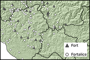
I found a very interesting article on the various chiefdoms of Garhwal before the region's unification by Ajay Pal, where they attempted to use visibility networks to estimate the borders of Katyuri era mandalas and post-Katyuri chiefdoms that originated out of the old Katyuri mandalas. Each color below represents an estimated chiefdom, centered around one or two central garhs and with several peripheral garhis.

Here's another labeled depiction of the organization of potential chiefdoms:

Here's a link to the article:
 www.cambridge.org
Here's another labeled depiction of the organization of potential chiefdoms:
Here's a link to the article:
Networked medieval strongholds in Garhwal Himalaya, India | Antiquity | Cambridge Core
Networked medieval strongholds in Garhwal Himalaya, India - Volume 95 Issue 381
www.cambridge.org
Last edited:
- 1
God damn man! You just began to look into this subject and already found a new paper! Are you by any chance a professional historian?I found a very interesting article on the various chiefdoms of Garhwal before the region's unification by Ajay Pal, where they attempted to use visibility networks to estimate the borders of Katyuri era mandalas and post-Katyuri chiefdoms that originated out of the old Katyuri mandalas. Each color below represents an estimated chiefdom, centered around one or two central garhs and with several peripheral garhis.
View attachment 1160850
Here's another labeled depiction of the organization of potential chiefdoms:
View attachment 1160851
Here's a link to the article:
Networked medieval strongholds in Garhwal Himalaya, India | Antiquity | Cambridge Core
Networked medieval strongholds in Garhwal Himalaya, India - Volume 95 Issue 381
- 1