• We have updated our Community Code of Conduct. Please read through the new rules for the forum that are an integral part of Paradox Interactive’s User Agreement.

Tinto Maps #8 - 28th of June 2024 - Russia

Hello, and welcome one more week to Tinto Maps! This week we’ll be taking a look at Russia!

As an introductory note, we’re just considering today the ‘Russian core’, which in 1337 comprised the different Russian Principalities, as far as the White Sea to the north, and the Ural Mountains to the east. The lands that would later be incorporated into the Russian Empire will be covered in future Tinto Maps (otherwise, we would have to cover like… 1/8th? of the land mass in just one DD).

Countries
Countries.png

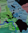
Russia is divided into several Principalities in 1337. The dominant one probably is Muscovy, as its Grand Prince, Ivan I Danilovich ‘Kalita’ (‘Moneybag’) is also Prince of Nizhny Novgorod and Kostroma, and of Novgorod (by election, in this case). He also holds the title of Grand Prince of Vladimir, bestowed by the Khan of the Golden Horde, which makes him the ruler enforcing the ‘Tatar Yoke’ over other Russian Principalities (which in our game is represented through an IO; the coloring of the different countries is different tones of yellow as they are tributaries of the Yoke). The other main power in the region is the Grand Republic of Novgorod, with a completely different institutional structure, that allows them to pick their rulers. Their power comes from being the main trading power between the Baltic Sea and the Russian region, and it’s the overlord of two border countries, the Principality of Pskov, and the County of Oreshek, a buffer country in Karelia, as agreed with Sweden after a recent war. Several lands to the north and east are not owned by any country. As a final note, you may also see that Lithuania is the overlord of some of the principalities, some of them directly through Gediminid rulers (Polotsk or Vitebsk), while other over Rurikovich rulers (Smolensk or Rzhev).

Muscovy.png

Tatar Yoke.png

The starting diplomatic of Muscovy and the Tatar Yoke IO, for the sake of clarity.

Dynasties
Dynasties.png

Several branches of the House of Rurik rule over the Russian lands. Fun fact: we have 18 different branches portrayed in the game. The exceptions are a few principalities, and the ruler of Karelia, Prince Narimantas of the Lithuanian Gediminids. Also, the 'Cherdyn' and 'Vyatka' are randomly assigned dynasties, as we haven't been able to get the data for those countries on 1337.

Locations
Locations.png

We’re showing a less detailed region this week because, well, Russia is big. Feel free to ask for more detailed screenshots of specific areas, and I’ll try to provide them. We’re also showing some parts of the Steppe, Finland, and Kola, because of the scale of the map; take them as ‘unavoidable spoilers’, as we’ll talk more in-depth about them in future Tinto Maps.

Provinces
Provinces.png

The provinces of Russia. As usual, suggestions are welcomed!

Terrain
Climate.png

Topography.png

Vegetation.png

Terrain map modes. As discussed in previous Tinto Maps, we’ll read carefully your feedback, as we have plenty of room to polish them!

Cultures
Cultures.png

Cultures! As in other regions, we decided to have three different cultures in the Russian region, Novgorodian, Muscovite, and Severian. The design here is different than in the Ruthenian region, because Russia was more politically divided in the High Middle Ages, and would later be more culturally unified later on, while in Ruthenia, the situation would be the opposite. In any case, the four of them are East Slavic cultures, and we're open to feedback, of course. Apart from that, there are a bunch of different cultures bordering the region: Karelian, Pomor, Komi, Udmurt, etc. We might add some more minorities of these cultures, in the feedback pass after this DD. Also, take into account that the minorities over the Tatar lands (currently under the Kazani and Mishary cultures) are not yet done.

Religions
Religion.png

Eastern Orthodoxy is dominant in the region, although there are other religions in the area, as well; take ‘Animist’, ‘Tengrist’, and ‘Shamanist’ as wide categories, as we’d like to add a bit more granularity for them (although that will come later this year, don’t expect them to be added in the coming Tinto Maps, but maybe on the later ones). We’ve already seen some posts asking about Slavic Paganism; up until now, we’ve considered the Russian people to be Christianized, even if it was a more or less superficial process. If you’d like us to add this religion and some percentage of the population adhering to it, then I’d ask you for specific sources that could help us portray it (so, isolated references to it being followed here or there won’t be helpful, while academic sources saying ‘up to X% of the population was following Slavic rites’ might very much be).

Raw Materials
Raw Materials.png

Quite different resources to other regions previously shown, with plenty of Lumber, Fur, and Wild Game in this region. I’ve also extended a bit the screenshot to the east, so you can see the mineral richnesses of the Ural Mountains, with plenty of locations with Copper, Iron, Gold, and Lead, making it quite juicy to colonize.

Markets
Markets.png

The counter to the richness of the natural resources of the region is its integration into the different markets, which at the start of the game are centered around Novgorod, Moscow, and Kazan. Fully exploiting the economic possibilities of Russia will therefore require effort and patience.

Country and Location population
Country Population.png

Location Population SW.png

Location Population SE.png


Location Population NE.png

Location Population NW.png

Not many people inhabit the Russian core, approximately 6M in total. This poses a series of challenges regarding the expansion of any Russian country. Also, we've divided into 4 different maps of the location population of the region, to make it possible to visualize. A side note: you might note that the population of NW Novgorod and Karelia is calculated a bit differently. That's because Johan took care of drawing the Scandinavian map in an early stage of development, and the Content Design team took over the rest of Russia at a later stage when we had already refined a bit more our population calculation methods. This means that when we do the feedback pass after this Tinto Maps, in a few weeks, we'll homogenize the style, as well.

And this is all for today! We hope that you’ll find it interesting, and give us great feedback! Next week we’re traveling to Carpathia and the Balkans! See you!
 
  • 162Like
  • 67Love
  • 7
  • 6
  • 5
Reactions:
Sorry, dont know if its in this thread this would be appropriate:

Trade in Novgorod node:

- Came to think about the Gotlandic trading post in Novgorod city, established in the 10th century and in its fullest strength in the 12th century.
- Should Gotland start the game with a trading post or similar building/boost to trade in Novgorod?

-what about the later Hanseatic League trading office in Novgorod? Could it be a mission branch for the league to take control of the eastern trade. They had offices in Reval, Viborg and Nöteborg (Slisselburg in German) too.
-and would it be appropriate to set a small minority Germans in at least Reval, Viborg and Nöteborg? I dont have any data on Germans in Novgorod..

- Norwegians tried to take a bigger pie of the novgorodian nodes trade in the early Middle Ages trough sea lanes into the white sea and arkhangelsk area, but historically it dvindled into obscurity. Could Norway get a mission to try and grab the northern part of novgorods trade?
A minority with Norwegian descent should be present in arkhangelsk on the game start, but i dont have any data..

- as Gotland had a trade office in Novgorod, Novgorod had a similar office in Gotland. Should Novgorod have trade power in the Baltic node as well? And a sliver of minority on gotland?

-Novgorod and Sweden fought over the trade of Bjarmia and the trade the birkarlar generated, as well as who would have the right to tax the Sami. Is there plans on some missions for Novgorod/Sweden to get clashes in the far north?

-LATER EDIT:
- if i continue the thought with the little i know:
- would there be a mechanic for the states/countries to propagate their religion in other tags? Via missions or a mechanic??
In conjunction with the Gotlandic trade post "The Gothic Yard" was a church to st. Olaf (present at game start). And wise versa had the Novgorodian trade post in Gotland a Orthodox church attached (present at game start).
And when the Hansa gained influence they too erected churches (not present at game start). The German church i Viborg was the biggest and wealthiest in the city for instance. So something to push the religion, or a mission to "assist our brethren in location xx".

YET LATER EDIT:
- could the Orthodox monasteries in the region be influential in some manner? Like Valamo, Petsamo, Solovetsky etc?
 
Last edited:
  • 4Like
Reactions:
Russia Uralic Updated again.png


I've taken everyone's feedback and I've updated my cultural map. Hopefully this will be the final version, but if you have any feedback please tell me again, I do want to make this map perfect.

Hello, please read the message ive left on this thread before about the cultural landscape of karelia, the map is almost correct
Thanks for the info on the Sámi, I've added them to the north of lake Onega and everywhere that they were present. I also had to change their colour because otherwise they would have been hard to distinguish from the Karelians, however I didn't change the Sámi colour in Murmansk because I don't think they should actually be Orange, I only did it for illustrative purposes.

Great work. One thing that bothers me is Kosmodemjansk being fully Chuvash. I think you can add stripes to it. I managed to find data only from 1897 (first Russian empire census), but it states 47% are Chuvash and 37% Mari. If your source is better I would love to look into it.
Fair point, I've changed it now.

The Udmurts should be constrained mostly in the Vyatka-Kama interfluve and not reach so far north. As for Bjarmians archaeological research on them is pretty poor, but Lower reaches of Northern Dvina is where they are usually placed instead of Mezen which was settled by the Permian Vanvizdin culture and thus should be Komi. Mari could reach all the way to the Vetluga to the west. Zavolochye Chud' could be in the upper reaches of Northern Dvina. Also I would like to know if Meschera really were still a thing as late as this time period. Nenets should also not reach so far south in the Pechora basin. I don't know if naming the Belaya river Ugrics Ungri would be a good idea since the exonym comes from the association of Hungarians with Huns in the Pannonian basin where their cousins ended up in. Perhaps they should be named simply Magyar or Chiyalik as pointed out earlier here. Mansi are the more westernly group of the Siberian Ugrics. Also should there be Erzya in the east this early on?
You are right that the Udmurts were concentrated in that region, but they also did reach further north, it's just that northern Vyatka is sparsely populated, but the few people who lived there were Udmurts. See the Vyatka principality for more details. As for the Bjarmians, I'm not touching them anymore, I know that I said that I wanted to make the map perfect, but I'm breaking that rule when it comes to the Bjarms. They're a nightmare to research and almost all of the evidence comes from a small amount of archaeological sites, also many of the sources are in Russian and impossible to track down. So I'm giving up on researching them, it's not worth it.

As for the Meshchera, yes they were definitely present in 1337, in fact the last accounts of their presence are from the 16th century. They survived for so long because the lived in the Meshchera lowlands, which were extremely swampy and never had much large scale Russian settlement. I actually underrepresented them originally as I misjudged the size of the Meshchera lowlands; I've also added a Severian minority to the Tuma location, as there were Russian settlements on the north bank of the Oka river, which is in the Tuma location.

Finally the Ungri, Fair point about the name, the term Ungri is only used in Eastern Roman, Arabic and Frankish sources. So I've instead changed the name to the old Magyarok word for Magyar, which is Mogyer; it's not a perfect name but it's the best I could think of. I also expanded Mogyer to include the region of Magna Hungaria, which was Mogyer in the 1230s according to the accounts of Friar Julian. To verify this, I read This Journal on the connections between many Uralic and Ob-Ugric peoples to the Hungarian conquerors. The Journal backs up the conclusion that the Chiyalik culture was related to the Kushnarenkovo and Karayakupovo cultures, which lived in the region of Magna Hungaria at the time of Friar Julians travels. The evidence points towards all 3 of these cultures being related to the Magyars, it also points towards the conclusion that these peoples lived in these regions as late as the early 14th century, although this link isn't as strong with the Kushnarenkovo and Karayakupovo cultures.

Finally I added a Kazani minority to the Kungur location, to represent the Gaina tribe. Who underwent Kipchakisation starting in the 13th century and are often regarded as a Volga Tatar people from the 14th century onwards.

That's all the changes I've made so far, I might make more later, but it depends on how much feedback I get on the map. I still could portray Arkhangelsk better, but it would take a long time to do the research. Even then, my portrayal of the Arkhangelsk area is still an improvement over the original Tinto map, so I hope it helps when the new cultural map for the Russia region is made, when the Russia feedback thread is made. Anyway, that's all for now, bye.
 
  • 15Like
  • 3Love
  • 2
Reactions:
I'll twist this comment further:
if researchers couldn't come up with period-relevant names for given locations as of 1337 - should these locations feature in the game at all?
I mean yes, why not, what even is the alternative? I would take Leninotrotskygrad in the middle of Siberia over the location not existing at all.
 
  • 2
  • 1Haha
  • 1
Reactions:
I mean yes, why not, what even is the alternative? I would take Leninotrotskygrad in the middle of Siberia over the location not existing at all.
Either an empty uncolonised unnamed location or a less granular, bigger location.
Well, yes, location not existing at all is also an option.
 
  • 2Like
  • 1
Reactions:
Either an empty uncolonised unnamed location or a less granular, bigger location.
Well, yes, location not existing at all is also an option.
Location not existing at all is probably not an option since it will eventually be colonized. It's either a wasteland or a location. Unnamed location is also hard to implement as a game thing, like how do you tell locations apart from each other? Places with no endonyms reliably known in 1337 are probably like half the entire planet. Bigger location is the only feasible one, but people seemed to hate the massive Siberian provinces that took forever to traverse in EU4, and I think many players would hate that to come back.
 
  • 5Like
Reactions:
I've taken everyone's feedback and I've updated my cultural map. Hopefully this will be the final version, but if you have any feedback please tell me again, I do want to make this map perfect.

Pretty sure the Veps should also be a bit more to the west of where you put them, basically covering the entire immediate area south of the Syväri (Svir). This is what was still left of them c. 1900 (the map has some anachronisms with artificial lakes that did not exist until the 1950s, most notably the Ivinsky Spill, but ignore that):

vepsakartta2.jpg

What's going on with the Sami in your map, north and west of Lake Onega? Shouldn't they be contiguous with the rest of their people to the north? Also, isn't their existence in this area as late as 1337 disputed? If memory serves, we don't know for certain which Finnish or Finnic tribe dwelled there around this time. The Sami definitely still lived in White Karelia, however.

As for the game representing Karelians and Ingrians (which I assume is supposed to refer more so to Izhorians, and perhaps Votes) as something separate from the Finns but not doing the same for Savonians, Tavastians, Kvens, etc. or the Sveas, Geats, Scanians, Norrbotteners, Jämtlanders etc. in Sweden, or the various regional identities in England, Novgorod, Moscow, or a million other places... Personally I think it's arbitrary, but I guess it's a casualty of 20th and 21st century politics that won't change without modding the game once it's out. I didn't want to mention it in my previous post so as to not derail it from the map errors, but I've mentioned it now.
 
  • 1
Reactions:
The Severian culture on the map is too large and extends too far to the east and north of the settlement region of the Severian tribe and their probable descendants in the 14th-17th centuries - the ethnic community of the Sevruks (Sevryuks).

The last mention of the Severians is from the 12th century, but in the 14th-17th centuries, sources mention the Sevruks in approximately the same lands. This is a rather mysterious East Slavic ethnos, which has not yet been sufficiently studied by scientists, but in general historians agree that Sevruks are most likely a changed name of the descendants of the Severian tribe.

The Sevruks lived in the region of Severia and its surroundings, where there are such cities as Chernihiv, Lyubech, Novhorod-Siverskyi, Hlukhiv, Putivl, Rylsk, Starodub, Bryansk, Kursk, Oryol, Voronezh. They are also mentioned on the modern Ukrainian Left Bank of the Dnieper approximately before the confluence of the Samara River with the Dnieper in the south (where Poltava, Pereyaslav, Lubny, Kharkiv are now). But it is worth noting that in the southern part of the Left Bank of the Dnieper in the 14th and 15th centuries there was generally little settled population as a result of the devastation by the Mongols.

The way of life of part of the Sevruks (guard service on the border with the steppe, remote resource gathering, skirmishes with the Tatars and robberies) resembled the Cossacks. Actually, the southernmost Sevruks apparently took part in the formation of the Zaporozhian Cossacks in the 15th century. The most prominent activity of the Sevruks was honey hunting. Severia was one of the main suppliers of honey to the Moscow principality, and the population of this region was often called simply "honey hunters" ("бортники") in Moscow diplomatic documents because of their main occupation.

Later, in the 17th century, massive migrations took place on the territory of the Sevruks from the west (Ruthenians, initially as a result of the colonization of the Left Bank of the Dnieper by the subjects of Prince Vyshnevetskyi and later as refugees from the bloody events of the Khmelnytskyi uprising) and from the east (Russians, initially tsar service class people and peasants who settled the territories near the defensive "Zasechnaya line", along with the subsequent repressions against the local population for supporting False Dmitry and participating in the Uprising of Bolotnikov during the Time of Troubles), as a result of which the Sevruks were assimilated and dissolved into the composition of modern Ukrainians (in the area of Chernihiv, Novhorod-Siversky and Kharkiv) and Russians (in the area of Bryansk and Kursk).

In the sources, this ethnic group was last mentioned at the beginning of the 18th century.

Below I present the approximate limits of the settlement of sevruks on location maps:

Locations.png


Locations (1).jpg


Used sources (in Ukrainian):
Balushok V. Mysterious sevryuks: 1. Community formation // Siveryanskyi litopys : journal. — Institute of History of Ukraine. – Chernihiv, 2015
Balushok V. Mysterious sevryuks: 2. Ethnic nature of the community // Siveryanskyi litopys : journal. — Institute of History of Ukraine. – Chernihiv, 2016
Balushok V. Mysterious sevryuks: 3. Between Ukrainians, Russians and Belarusians // Siveryanskyi litopys : journal. — Institute of History of Ukraine. – Chernihiv, 2016
Balushok V. Mysterious sevryuks: 4. Ethnocultural features // Siveryanskyi litopys : journal. — Institute of History of Ukraine. – Chernihiv, 2016
Balushok V. Mysterious sevryuks: 5. The name problem. The territory and the state of its population // Siveryanskyi litopys : journal. — Institute of History of Ukraine. – Chernihiv, 2016
Balushok V. Where did the sevryuks go? // Scientific works of Kamianets-Podilskyi National University – Kamianets-Podilskyi, 2017
Articles by this author in PDF format
 
  • 3Like
  • 1
Reactions:
Location not existing at all is probably not an option since it will eventually be colonized. It's either a wasteland or a location.
"Location not existing" means "wasteland" to me.
Unnamed location is also hard to implement as a game thing, like how do you tell locations apart from each other?
IIRC all locations have numeric IDs in the database, don't they?
Places with no endonyms reliably known in 1337 are probably like half the entire planet.
I don't mind half the planet as wasteland, tbh.
Bigger location is the only feasible one, but people seemed to hate the massive Siberian provinces that took forever to traverse in EU4, and I think many players would hate that to come back.
I'll try using examples from the original post #500.
I would admit that locations like Troitsko-Pechorsk look quite large as they stand. However,
Yelovo is a vivid example to me. Wiki says it was first mentioned as a village around 1646. Should it be a wasteland? I guess not because it WAS settled within game's timeframe eventually. Should it have a native, pre-Russian state with its own name instead of being a colonizable location? I dunno, I won't pretend I know the region. Should it be merged into a bigger location? I would seriously consider that, though I guess we have to account for regional balance & stuff.
 
  • 1Like
Reactions:
View attachment 1156934

I've taken everyone's feedback and I've updated my cultural map. Hopefully this will be the final version, but if you have any feedback please tell me again, I do want to make this map perfect.
This is far from the latest version. The Pomors descended from the Novgorodians, and continue to turn into them, you can safely draw Novgorod minorities in the Kholmogorie and the provinces adjacent to the sea. Meshchery in the north should be mixed with the Moscow minorities. After your changes, the Karelians look bad. Erzya and Moksha are close enough peoples to mix. Russian cultures will mix even more significantly, and the same will happen with the Tatars (Mishars, Kazans, Bashkirs, Nogai minorities). In addition, the issue of semi-mythical Severian culture is still not closed on your map.
 
Some feedback about Finnish Karelia:
1) The Swedish eastern border is somewhat too far to the west. The borderline was well documented throughout the Karelian Isthmus in the Peace of Nöteborg (1323), and would go pretty closely along the blue line on the map below.

1719854276448.png


Reference: a map from Suomen historian kartasto (Karttakeskus, 2007).

1719867947208.png

2) I'd like to see a bit more precise border at the east, defined by the Treaty of Stolbova. The narrow purple line would be a more accurate northern border for the province (defined by the Treaty of Teusina)

1719867576425.png


Reference: a map from Suomen historian kartasto (Karttakeskus, 2007) showing Finnish provinces in 1635

1719868192606.png


3) Some of the location names are anachronistic or misplaced. Below is my suggestion for province names, based on congregations established already on 1337, or as soon after that as possible.

1719867056648.png


From north to south:
- Lieksa --> Pielisjärvi (Lieksa was founded in 1936, Pielisjärvi is the original name)
- Möhkö (a tiny settlement) --> Ilomantsi
- Ilomantsi --> Kontiolahti (the oldest congregation in the area, founded 1737)
- Joensuu --> Liperi (city of Joensuu was founded in 1848, Liperi congregation in 1630)
- Loymola (a tiny settlement) --> Pälkjärvi (congregation founded in 1630, apparently mentioned already in 1500)
- Värtsilä --> Kitee (only became an independent municipality in 1920, Kitee is an older and more important settlement, taxed by Novgorod in 15th century)
- Lahdenpohja --> Kurkijoki (Lahdenpohja was founded in 1924, Kurkijoki congregation in 1396)
- Jäskis --> Ruokolahti (Jäskis is located south of the province)
- Kouvola --> Valkeala (Kouvola was founded in 1922, Valkeala is the oldest congregation in the area, founded in 1614)
- Heinjoki --> Jäskis
- Villmanstrand --> Lappee (congragetion founded in 1437, city of Lappeenranta/Villmanstrand in 1649).
- Kexholm --> Korela (the name used before 1611)
- Fredrikshavn --> Veckelax (Fredrikshavn/Hamina was founded in 1723, Veckelax/Vehkalahti is the original name of the settlement). The congregation was founded in 1396.
- Kyyrölä --> Äyräpää (Äyräpää congregation was founded 1348, and was one of the locations mentioned in the Peace of Nöteborg)
- Kut??? --> Sakkula (can't make out the orginal name, but Sakkula/Sakkola is and old congreagtion in the area)
- Koivisto --> Björkö (if the Swedish name is to be used at game start)
- Valkeasaari (?) --> Kivinebb/Kivennapa (congregation founded in 1445, Valkeasaari is on the other side of the border at this point)

Furthermore, I would remove Toksovo from the province of Karelia, since it never was a part of any Finnish Karelian province, but Ingria, instead (see previous reference map). A more precise border between Karelia and Ingria would be this:

1719868436255.png


References for the foundation dates:
- http://www.pcuf.fi/~rdahl/kirkko/seurakunta.html
- http://hiski.genealogia.fi/seurakunnat/mini1s.html

I would change some location names in Savo, as well, but I'll leave that for the Tinto Maps containing Finland.
 

Attachments

  • 1719864862888.png
    1719864862888.png
    244,7 KB · Views: 0
  • 1719867907902.png
    1719867907902.png
    866,7 KB · Views: 0
  • 14Like
  • 4
Reactions:
Seams wrong for pre-Russian Perm region to have Russian names:

Cherdyn' - subjugated by Moscow in 1472:
Dobryanka - from Dobryi /добрый/ means kind in Russian.
Solikamsk - from Sol' /соль/ means salt in Russian (kamsk - means on river Kama).
Koygorodok - from gorod /город/ means town in Russian.
Afanasyevo - from Russian name Afanasiy /Афанасий/.
Chernaya - /Черная/ means black.
Troitsko-Pechorsk - from Troitsa /троица/ means trinity. Usually in context of sacred trinity, a term from Christianity.
Beryozovka - from Beryoza /береза/ means birch.
Yelovo - from yel' /ель/ means pine in Russian.

Vyatka subjugated by Moscow in 1489:
Orlov - from orel /орел/ means eagle. Now Orlov is a very common Russian family name.
Belozerye - from beloe /белое/ means white and ozero /озеро/ means lake.
Nagorsk - na /на/ means on. Gora /гора/ means mountain.
Nikolsky - from Nikolay /Николай/ common Russian name.
Do you have suggestions on native names to replace them with?
 
I'll twist this comment further:
if researchers couldn't come up with period-relevant names for given locations as of 1337 - should these locations feature in the game at all?
Isn't that an obvious "yes"? If it's settled before 1835 it should be in the game.
 
  • 1
Reactions:
Some feedback about Finnish Karelia:
1) The Swedish eastern border is somewhat too far to the west. The borderline was well documented throughout the Karelian Isthmus in the Peace of Nöteborg (1323), and would go pretty closely along the blue line on the map below.

View attachment 1156922
You are completely right, but only this is the border between Novgorod and Sweden. The agreement discussed not only borders. This is a pretty unique situation and Tinto probably won't develop mechanics specifically for it. The addition of the county of Oreshek is justified, since this is how other clauses of the agreement can be mechanically observed in the game. And instead of a historical border, the Swedes can be given permanent rights to a territory that will be national to them.
 
  • 1Like
Reactions:
View attachment 1156934

I've taken everyone's feedback and I've updated my cultural map. Hopefully this will be the final version, but if you have any feedback please tell me again, I do want to make this map perfect.


Thanks for the info on the Sámi, I've added them to the north of lake Onega and everywhere that they were present. I also had to change their colour because otherwise they would have been hard to distinguish from the Karelians, however I didn't change the Sámi colour in Murmansk because I don't think they should actually be Orange, I only did it for illustrative purposes.


Fair point, I've changed it now.


You are right that the Udmurts were concentrated in that region, but they also did reach further north, it's just that northern Vyatka is sparsely populated, but the few people who lived there were Udmurts. See the Vyatka principality for more details. As for the Bjarmians, I'm not touching them anymore, I know that I said that I wanted to make the map perfect, but I'm breaking that rule when it comes to the Bjarms. They're a nightmare to research and almost all of the evidence comes from a small amount of archaeological sites, also many of the sources are in Russian and impossible to track down. So I'm giving up on researching them, it's not worth it.

As for the Meshchera, yes they were definitely present in 1337, in fact the last accounts of their presence are from the 16th century. They survived for so long because the lived in the Meshchera lowlands, which were extremely swampy and never had much large scale Russian settlement. I actually underrepresented them originally as I misjudged the size of the Meshchera lowlands; I've also added a Severian minority to the Tuma location, as there were Russian settlements on the north bank of the Oka river, which is in the Tuma location.

Finally the Ungri, Fair point about the name, the term Ungri is only used in Eastern Roman, Arabic and Frankish sources. So I've instead changed the name to the old Magyarok word for Magyar, which is Mogyer; it's not a perfect name but it's the best I could think of. I also expanded Mogyer to include the region of Magna Hungaria, which was Mogyer in the 1230s according to the accounts of Friar Julian. To verify this, I read This Journal on the connections between many Uralic and Ob-Ugric peoples to the Hungarian conquerors. The Journal backs up the conclusion that the Chiyalik culture was related to the Kushnarenkovo and Karayakupovo cultures, which lived in the region of Magna Hungaria at the time of Friar Julians travels. The evidence points towards all 3 of these cultures being related to the Magyars, it also points towards the conclusion that these peoples lived in these regions as late as the early 14th century, although this link isn't as strong with the Kushnarenkovo and Karayakupovo cultures.

Finally I added a Kazani minority to the Kungur location, to represent the Gaina tribe. Who underwent Kipchakisation starting in the 13th century and are often regarded as a Volga Tatar people from the 14th century onwards.

That's all the changes I've made so far, I might make more later, but it depends on how much feedback I get on the map. I still could portray Arkhangelsk better, but it would take a long time to do the research. Even then, my portrayal of the Arkhangelsk area is still an improvement over the original Tinto map, so I hope it helps when the new cultural map for the Russia region is made, when the Russia feedback thread is made. Anyway, that's all for now, bye.
I still don't think the Udmurts should reach beyond Vyatka river. Your map shows them reaching the Luzha river which was inhabited by Komi not Udmurts. Seems like the Russians had reached the Vyatka river already by this period.

The Mögyer range could also be extended up to Kungur instead of Komi as the settlements there are part of the Chiyalik culture.
 
Last edited:
  • 1
  • 1Like
Reactions:
Want to add my voice to the idea that Russian culture should absolutely emerge at some point and in some form (even if just cosmetic in essence to replace one of the initial ones). Tie it to literacy level or whatever. Playing as imperial Muscovites or Novgorodians well into the 18th century would feel just wrong.

I don't feel like engaging in various disputes this thread seems to ignite so much, but think of it this way: were writers, poets or musicians of the era enriching Muscovite culture? Or rather Russian?
 
  • 4Like
  • 1
Reactions:
Not many people inhabit the Russian core, approximately 6M in total.
In the thirteenth century, the Golden Horde enumerated the population of the Rus' three times—1245, 1257, and 1274; according to censuses, the Rus' population was then estimated at approximately 10 million people.
(Stolen from Wikipedia)

* Borrero, Mauricio (2009). Russia: A Reference Guide from the Renaissance to the Present. Infobase Publishing. ISBN 978-0-8160-7475-4.

In previous maps of Poland there was around 3m Ruthenian people. It means 1 million of people for sure lost. The question is: is those 6M - only Russian culture pops? If not then more should be added
 
Do you have suggestions on native names to replace them with?
I think the best option would be to name these places after small local rivers. Because hydronyms usually store the oldest local names.
For example Kama. Siva, Silva, Tulva, Obva. Inva. Kosva, Usva.
All these names are pre-Russian, as can be seen from the characteristic ending of the word.
 
Last edited:
  • 6
  • 4Like
  • 1
Reactions:
Um... neither the page nor any Russian textbook ever call Ancient Russians древнерусские. The page name clearly uses древнерусские as an adjective, not a noun (which is народность, in this particular case).
While the page is indeed describing "Ancient Russian" narodnost, the rest is an outright falsity, and I am more than ready to call you out on that. The only time that the Old East Slavic peoples are not called "Ancient Russians" is prior to the arrival of the Rus and during the earlier periods of Rusian rule. It's asinine to deal with this. Especially given that I have studied Russian historiography and other essential elements to my arguments in Uni. I have encountered the term "древнерусские" and "русские" used as substantives in Russian to describe the Rusian people and members thereof. There is a purposeful conflation of the Rus people and the Muscovite, "Russian" people that I am glad to see Paradox not indulge in, and I would wish to end this petty debate on that note.
 
  • 5
  • 2
Reactions:
It seems to me that the method of dividing Russian culture is completely unacceptable; there have never been separate Moscow, Novgorod, and certainly not any Seversk cultures. Such a division would be much more logical: Russian or Central Russian - the central Russian region, Northern Russian - the regions of Vologda, reflecting the migration of Russians to the north, Pomeranian - already represented on the map, Southern Russian - regions south of Ryazan and on the border with the steppe and possibly with Lithuania state, in the future this culture could become the Cossacks.
 
  • 1Like
Reactions: