• We have updated our Community Code of Conduct. Please read through the new rules for the forum that are an integral part of Paradox Interactive’s User Agreement.

Tinto Maps #15 - 23rd of August 2024 - Horn of Africa

Hello, and welcome one more week to Tinto Maps! After a short break, we’re back to the duty of sharing more maps! Today the region we will look at is the Horn of Africa! So let’s take a look at it, without further ado:

Countries:
Countries.PNG

Here we have the countries around Nubia, Ethiopia, and Somalia. The first ones are organized around the ancient kingdoms of Makuria and Alodia, which control the Upper Nile region. In the second area, the Empire of Ethiopia stands as the main power, with some smaller countries around it. Finally, the two Islamic sultanates of Ifat and Ajuraan stand as the main powers in the Horn and Somalia. Finally, around the African Great Lakes, there is a country that can be considered a ‘settled’ one, Kitara.

Dynasties:
Dynasties.PNG

The dynasties of the Horn. There are some historical ones, while others are randomly generated. The most famous one is probably the Ethiopian House of Solomon, from where all their Negus come. The Walshma ruler over both Ifat and Ajuraan and we have some others, such as the Medri of Medri Bahri, the Umar of Mogadishu, the Banu Kanz of Makuria, or the Baranzi of Kitara.

Societies of Pops:
Pop-Based.PNG

A new map has popped up! Here you can see the countries that we consider as ‘Societies of Pops’, as they were presented in the last Tinto Talks. We have the famous Oromo people in the lands between Ethiopia, Ifat and Ajuraan; the Kunama, Gumuz, and Berta in the lands between Ethiopia; and Alodia, and the Zaghwa to the north of Wadai; there are a few more to the west, but I’ll share that picture in the Western Africa thread, as it’s more appropriate there. There are more Stateless Societies of this kind that we would like to add in the future, if it is possible due to our schedule.

Locations:
Locations.PNG

Locations 2.png

Locations 3.png

Locations 4.png

Locations 5.png
Locations! You might notice that the density is quite unequal. Unfortunately, the archaeological findings for the period are scarce, specially out of the most known areas and a lack of urbanization in most of the territory has made the finding of proper non-anachronistic settlements quite a challenge. Keep this in mind when making suggestions. ;) It has been that dramatic in some areas that we had to use names of tribes and rivers, a bit contradicting our own rules, but the areas had to be represented as they were active parts in the development of the region.
One thing: a big chunk of the Arabian peninsula can be seen in today’s Tinto Maps; but, please, reserve the feedback for its future DD, when we’ll show all of the peninsula. Apart from that, you can see more detailed maps if you click on the spoiler button, as usual.


Provinces:
Provinces.png


Areas:
Areas.png


Terrain:
Climate.png

Vegetation.png

Topography.png

The terrain types of the region are quite interesting and diverse. It is marked by the Rift Valley, which creates different biomes, such as the Ethiopian Highlands and Plateau, or the African Great Lakes. That also marks a divide between Arid, Tropical, and Oceanic climates. The vegetation of the region also ranges from desertic and sparse, to jungle forests. And one more note: you may also note that 'Marshes' have been renamed into 'Wetlands', as we could put some work into that suggestion the last week.

Natural Harbors:
Natural Harbors.png


Cultures:
Cultures.png

Another interesting map this week… You might notice that the lands of Ethiopia have a very mixed cultural situation. While more to the west and south, we are representing ‘tribal lands’ in a more homogeneous way, with kind of fixed boundaries to represent the different groupings. This doesn’t mean that there wouldn’t be a mixing of cultures, but this was one of the first areas to receive a minority's review and the scope was limited mostly to Ethiopia.

Religion:
Religion.png

Another interesting map! Miaphysite and Sunni are the more widespread religions in the region (while not all areas have their mixed populations, such as Nubia as you might notice, they eventually will as we cover more of the map in our sprints). Animism is completely placeholder, as usual, and you might see some pockets here and there (If you have specific suggestions, please do them). You may also notice a purple minority inside Ethiopia… That is representing the Beta Israel Judaism in the provinces of Semien, of course!

Raw Materials:
Raw Materials.png

The raw materials of this week! A big chunk of the region has livestock as its main raw material, while also having some agricultural goods as Wheat or Sturdy Grains here and there. The most unique good in the region is Coffee, which is cultivated in the Ethiopian highlands. And there are also some precious resources spread here and there, such as Gold, Ivory, Gems, and Incense.

Markets:
Markets.png

The main market centers of the region are Axum and Mogadishu, with ‘Adan/Aden being the main one controlling the access to the Red Sea. There are some weird calculations ongoing on the Somalian inner lands, that are already reported, and we’ll take a look at why is that happening.

Population:
Population.png

Population 2.png

Population 3.png

Population 4.png

Population 5.png
The population of the region! There are approximately 12.3M people in the Eastern African subcontinent; although take into account that it also comprises the regions of the Southern Great Lakes and the Swahili Coast, which we haven’t shown today, so we probably have to discount around 4M people from it (Swahili Coast accounts for 1.7M, and the Great Lakes for 4M, although that region is divided between today’s and next week’s Tinto Maps), for a total of around 8M.

That’s all for today! Speaking of next week’s Tinto Maps, it will be meaty, as it will cover Central, Eastern, and Southern Africa! See you!
 
  • 126Like
  • 39Love
  • 5
  • 4
  • 1
Reactions:
Baqlin Sultanate 700 — 1557
The Baqlin sultanate straddled the Rora valley (in the Sudan) and stretched to the Eastern slope of the Eritrean highlands. The Baqlin sultanate, along with its neighboring sultanates were the result of an invasion of Beja from Sudan but intermingled without imposing a new culture. The Baqlin were a semi-nomadic sultanate that raised and sold camels and cattle to its neighbors. The cause of decline of this Beja kingdom is unknown, however, in 1557 it succumbed to the Ottoman Empire.
Qata Sultanate 700 — 1557
The Qata sultanate was located from just south of Massawa to beyond Adulis and the Gulf of Zula near the Buri Peninsula. The primary commercial activity of this sultanate was mining and slave trade through the Dahlak sultanate out of the African interior to the Arabian peninsula and beyond. The ultimate cause of decline of this Beja kingdom, in the 16th century, is unknown, however, the constant warfare with its neighbors in pursuit of the slave trade, coupled with attacks by the Portuguese, weakened the sultanate. In 1557 it succumbed to the Ottoman Empire.

Jarin Sultanate 700 — 1557

Jarin sultanate (kingdom) stretched from the Barka valley in the west to the Massawa in the east. The Jarin sultanate, along with its neighboring sultanates were the result of an invasion of Beja from Sudan, particularly near the Nile valley, but also an intermingling without an imposition of a new culture. The primary commercial activity of this sultanate was mining and slave trade through the Dahlak sultanate out of the African interior to the Arabian peninsula and beyond. The cause of decline of this Beja kingdom, in the 14th century, is unknown, as with its neighbors. The most likely explanation is the slave trade that they were engaged in likely caused continuous war with its neighbors which eventually depleted the sultans control of their respective region. Which coupled with the rise of the Belew kingdom to the east and the rise of the Ottoman empire on the coast finally led to capitulation. In 1557 the Ottoman empire decisively moved in throughout the Eritrean coast, adding the Qata and Baqlin sultanate's as well.

Bazin Sultanate 700 — 1400
The Bazen sultanate was located in the western lowlands of Eritrea. The Bazen were primarily sedentary cultivators, meaning non-nomadic. In spite of the Beja rule, mass conversion of the indigenous population did not take place and they retained their faith to local religions. The cause of decline of this Beja kingdom, in the 14th century, is unknown however it occurred coincident with the rise of the Belew Kingdom. This Kingdom stretched from central Sudan and throughout the lowlands of Eritrea.

For the past two maps that have had them, aka this one, and Egypt, I was hoping that there would be something for the Beja, since they have had states since the 9th century, and this was a period prior to Arabization and Islamization of their people, where their states didn't use Arabic, and they were Miaphysite practicing religion-wise. Alas, they're currently shown with very little, which is disappointing. Only two of their states are present on the map which are Bazin and Jarin, which there definitely were more. There was Belgin, Qita'a, Nagash, and Tankish, all of which were Miaphysite Beja states recorded since the 9th century, which were all conquered by another Beja state that was more islamized, Belew in the 15th century. Adding in more Beja states could better represent them and their people as right now it's rather dull in my opinion.
Keep in mind that the only source for these Beja "kingdoms" is al-Yaqubi, who lived in the 9th century. It has been proposed by R. Fattovich, however, that these supposed "kingdoms" were not polities, but simply different ethnic groups, not necessarily even Beja ones. "Naqis" in the north might have been Beja, but "Bazin" for example most likely referred to the stateless Nara and Kunama. The Baqlin supposedly performed dental avulsion, so might have been Nilotes. In any case, we never hear of these "kingdoms" ever again. O'Fahey & Spaulding's "Kingdoms of the Sudan" illustrates how in the 14th century, the most powerful Beja group were the Hadariba, whose numbers were bolstered by Bedouin tribes like the Rufa'a or Juhayna. According to al-Umari, who wrote in the mid-14th century, the Hadariba chief was called Samra bin Malik and grew rich from pillaging the interior:

"Then there is the Shaykh of the Hadariba Samra b. Malik, who disposes of great numbers and a redoubtable force, with which he makes incursions against the Abyssinians and the peoples of the Sudan, which brings him a rich booty. All the rulers of the interior as well as other Arabs have been commanded in writing to render him aid and assistance and to accompany him in his military expeditions whenever he desires."

So it appears that in 1337 there was a Hadariba polity that extended its influence throughout much of the Sudanese Eastern Desert, certainly extremely loosely organized. Since its center was Suakin it would have been under nominal Mamluk suzerainty.
 
Last edited:
  • 5Like
  • 3
Reactions:
Keep in mind that the only source for these Beja "kingdoms" is al-Yaqubi, who lived in the 9th century. It has been proposed by R. Fattovich, however, that these supposed "kingdoms" were not polities, but simply different ethnic groups, not necessarily even Beja ones. "Naqis" in the north might have been Beja, but "Bazin" for example most likely referred to the stateless Nara and Kunama. The Baqlin supposedly performed dental avulsion, so might have been Nilotes. In any case, we never hear of these "kingdoms" ever again. O'Fahey & Spaulding's "Kingdoms of the Sudan" illustrates how in the 14th century, the most powerful Beja group were the Hadariba, whose numbers were bolstered by Bedouin tribes like the Rufa'a or Juhayna. According to al-Umari, who wrote in the mid-14th century, the Hadariba chief was called Samra bin Malik and grew rich from pillaging the interior:

"Then there is the Shaykh of the Hadariba Samra b. Malik, who disposes of great numbers and a redoubtable force, with which he makes incursions against the Abyssinians and the peoples of the Sudan, which brings him a rich booty. All the rulers of the interior as well as other Arabs have been commanded in writing to render him aid and assistance and to accompany him in his military expeditions whenever he desires."

So it appears that there was a Hadariba polity that extended its influence throughout much of the Sudanese Eastern Desert, certainly extremely loosely organized. Since its center was Suakin it would have been under nominal Mamluk suzerainty.
Suakin should appear as a country. But it was probably not ruled by Hadarib. Hadariba as a clan ruled the city of Aydhab. Suakin was ruled alternately by two tribes, Balaw/Al-Khasa and Artega.

(1) The port city also came under the control of the Balu people (people of Arab origin), during the Palau Kingdom of Eritrea (12th-15th centuries)
(2) The port city also came under the control of the Balaw people (people of Agaw origin), during the Balaw Kingdom of Eritrea (12th-15th centuries)
(3)The port city also came under the control of the Balu people (people of Arab origin), during the Palau Kingdom of Eritrea (12th-15th centuries).
https://en.wikipedia.org/wiki/Massawa
(4)The port city would also come under control of the Balaw people during the Balaw Kingdom of Eritrea (12th–15th centuries)
(5)Habesh lost importance after the Yemeni revolt in 1569/1570 . [6] recognizing the difficulty of expansion and the few successes, the province was placed in 1591 under the authority of a local naib from the tribe or clan Balaw of the Beja , from a Samhar family, who had to pay an annual tribute , and only one Ottoman garrison would remain in Massawa.
(6)In the 14th century the sherifs of Mecca controlled Suakin, allied to the Begs, with the ruling clan of the Hadaribs, who controlled Aydhab. Both the Hadaribs and their sovereigns the sheriffs recognized Egyptian sovereignty. With the decline of Aydhab, the port of Suakin reached an important traffic being the main one in the north of Masawwa , both for trade and for pilgrims from the Sahel. The Hadaribs left Aydhab at the end of the 14th century and settled in Suakin. Probably because of a disobedience to the Mamluks, an expedition of these devastated Suakin in 1439/1440, being plundered; Suakin submitted; the Mamluks then used the site to send dissidents and outlaws.
The Funj Sultanate of Sennartried to control Suakin and fought against the Ottomans but never achieved effective dominance, although they had relations with the " Artega " or bege emirs of al-Kayf who had a share in the port revenues that he shared with the Ottomans ( in practice he only distributed the revenue when the Ottomans were strong enough to demand it by arms)
(7)The Al-Arteqa tribe is an Arab tribe that ruled Suakin for eight continuous centuries. It dates back to the migration of their grandfather Ali bin Abdullah Al-Da’i from Jabal Haram in Yemen to Massawa and then to Suakin . It was at that time under the Emirate of the Bali Al-Quda’iyah tribe and its emir was Ahmed Al-Balawi, so Ali Al-Da’i engaged the daughter of Prince Ahmed Al-Balawi to His son, Muhammad Jamal al-Din, and then he personally married the second part of the people of Suakin , who are the Beja al-Bouiknaab (the owners of blood), and he gave birth to his son Ahmed, nicknamed Basofer, so he secured his trade and his family by marrying the two strongest wings in Suakin . This family grew up and took Suakin as a headquarters for its trade, and they traded between Suakin , Massawa, Jeddah , Yanbu and Mocha.The strength of this family was so strong that the Sharif of Mecca appointed Muhammad Jamal al-Din as a judge over Suakin, and after Ali al-Da’i was assured of his family in Suakin , he returned to Yemen and spent the rest of his life there until he died and was buried there.
Alam al-Din bin Ahmed (Basoufir) bin Ali bin Abdullah al-Da’i was the first prince of the Arteqa over Suakin , by order of al-Zahir Baybars al-Bandaqdari in 664 AH to isolate the Balawi prince at that time and appoint Alam al-Din over her. . And there was a friendship between the Sharif of Mecca, Muhammad Najmuddin Abi Nami I, and the prince of Suakin Alam Al-Din, and this relationship was sealed by intermarriage. His mother was the science of religion in Suakin , and the genealogy of Ibn Anba, who died in 828 AH, mentioned him in his book “Umdat al-Talib fi Ansaab Al Abi Talib” where he said: “Izz al-Din Zaid al-Asghar ibn Abi Nami, the king of Suakin, was his maternal grandfather, and she is from Banu al-Ghamr ibn al-Hasan al-Muthanna.” .
Then, an order was issued by the Mamluk Sultan to appoint Zayd Al-Asghar bin Abi Nami as governor of Suakin in the year 719 AH.
The emirate returned again to the Bali tribe of Al-Qudaiya after Zaid bin Abi Nami for a period and then returned again to the Arteqa under the leadership of Abdullah Bush Al-Arteqi.
After the return of the emirate to Arteqa, they ruled Suakin for centuries, until the days of British colonialism, which fought against Arteqa for their standing and support for the Mahdist revolution and their support for the Mujahid Othman Digna. Suakin abandoned and became a ghost town.
(8) Suakin was under the authority of the Banu Numay family, the rulers of Mecca, which led to the consolidation of Suakin's connection with the Hejaz region, not only from a commercial point of view, but also from a cultural point of view. It was frequented and settled by a number of Hijaz scholars. Al-Sakhawi translated (vol. 1 p. 223, vol. 2 p. 413, vol. 3 p. 75) for some of those scholars in the ninth century AH (fifteenth century AD). See the translations in (Ahmed Elias Hussein, texts from Arabic sources, pp. 355-359).
In the fifteenth century AD, Al-Maqrizi mentioned when talking about the island of Suakin (Al-Moawads, p. 295), “and its people are a group of Beja called Al-Khasa, and they are Muslims and they have a king there.” Ibn Hawqal (70) explained that the place of Al-Khasa is between Wadi Baraka and the Red Sea. The Islamic Kingdom of Khasa arose in the area from Wadi Baraka in the south to the Suakin region in the north. But there is no information available about the date of its establishment. Al-Maqrizi, a century ago, Al-Dimashqi mentioned (236) that the Khas are connected to A’izab, and that “the lower people are infidels and the upper ones are Muslims.” Perhaps this indicates that the kingdom of Khasah existed in the fourteenth century.

(9)The Islamic kingdom of Khasa in Suakin was mentioned in the 14th century AD

(10)The Islamic Kingdom of Suakin 13-15 AD
The port of Suakin was mentioned from an early age in the Arab sources. It was mentioned in the fourth century AH (10 AD) by Al-Hamdani (Al-Hamdani, Description of the Arabian Peninsula, vol. 1, p. 22) and Ibn Hawqal (Ibn Hawqal, “The Image of the Earth”). ", pp. 60-62) within the cities of the Red Sea. However, it became famous and its name began to be repeated in the sources since the seventh century AH (13 AD) and it seems that before the seventh century AH it was under the rule of Beja because Ibn Battuta (in Mustafa Muhammad Musaad, Sudanese Arabic Library p. 254) mentioned that Suakin when he arrived there was under the rule “The Sheriff Zaid bin Abi Nami and his father is the Emir of Mecca, and his two brothers are its Emirs after him, and they are Etifa and Rumaitha... and she became to him by the beasts, for they are his uncles.”
It can be said that the Kingdom of Suakin under the rule of Beja was established before the 7th century AH / 13 AD, and then entered under the rule of the Mamluks in Egypt in 664 AH / 1265 AD, and the princes of Mecca recognized the authority of the Mamluk princes over their areas of influence. (Ibn Fadlallah Al-Omari, “Masalak Al-Absar” p. 246) It seems that the first mention of the inhabitants of Suakin came to Yaqut Al-Hamawi (Dictionary of countries, in Musaad Al-Sudaniya Library, p. 164) at the beginning of the seventh century (died 626 A.H.). ." Then the reference was made after that to Al-Nuwairi (Nahayat Al-Arb fi Foun Al-Adab, Al-Warraq website, vol. 1, p. 66) (d. 732 AH), where he said about its inhabitants: “A sect from the Beja called the Khasah, and they are Muslims and they have a king.”
The information of Al-Nuwari in the beginning of the eighth century, which often goes back to the seventh century AH, may not contradict what was mentioned by Yaqut, because Al-Dimashqi (d. 739 AH) said about the elite who are the inhabitants of Suakin, as al-Nuwayri mentioned above: “The lower people are infidels, and the upper ones are Muslims” ( Al-Dimashqi, Elite of Eternity in the Wonders of Land and Sea, p. 237) Ibn Saeed (Book of Geography, Al-Warraq website pg. 60) mentioned in the seventh century AH (13 AD) that the citizen of the Khasah in the north of the province enchanted him. The Seharta region is located in the north of the present-day state of Eritrea. It seems that the Khasa was a large and widespread tribe in the region, and Crawford (The Fung Kingdom of Sennar, p. 104) has suggested that the Qasa tribe is the same as the Khasa tribe that Ibn Hawqal mentioned (in Massad, Sudanese Library p. 71) to be a tribe. Large, with multiple bellies, extending three days' journey between Khor Baraka and Badi', and he said: "It is for the bellies of the Dakhla Al-Beja, the most valuable and the most precious."
The Islamic Kingdom of Khasa in Suakin was mentioned in the beginning of the eighth century AH (14 AD), which means that it existed before this date. He reached the African coasts of the Red Sea in the era of the Prophet, peace be upon him, then the influence of Muslims expanded in the islands and the port of Dahlak since the era of the Rightly-Guided Caliphs, and after that, Islamic ports flourished on the coast, such as the ports of Ba’idah, Azab and Suakin. Just as the history of the establishment of the Islamic Kingdom of Suakin requires research, so also its subsequent history needs attention. Al-Maqrizi (in Mus’ad, The Sudanese Library, p. 295) in the ninth century AH (15 AD) repeated the same Nuwayri phrases about the Islamic kingdom of Khasa in Suakin, at the time when the name of the blues appeared as kings in Suakin?

(11)The Bali tribe in Sudan
The Bali tribe and their Bejawi kingdom:
The Bali was the first tribe that migrated to Sudan from the Arabian Peninsula, and the residences of this tribe were in the Arabian Peninsula before Islam in northern Yemen and the areas south of Najd and north of the various land of Shihr and eastern Sudan and even Egypt and the Levant to Palestine.
It appears that it was a large tribe with abundant strength, as it was able to establish its feet in large parts of the Hijaz and then marched north to the lands of Palestine, where groups of them established there, then some of these groups and others descended through the Sinai in the west to Egypt, then the Arab Maghreb and south to the shores of The Sudanese Red Sea, where the Beja tribes lived, gradually mingled with them, then their regiments followed from the Hejaz and Yemen and crossed the Red Sea at Bab al-Mandab and from the marinas near Jeddah to the Sudanese shores until they covered all the Beja region from Aydhab in the north to Massawa and Dahlak in the south, where the people of Bejaweh tribes.
And these migrations had begun before the third century BC, and the Beja tribes dated using the word “Bloib and Balawit” for this Arab nation that descended on its lands. It contains the sons of the Bali tribe, and they were the first to speak Arabic in Africa.
Soon the leaders of this Arab tribe began to intermarry with the leaders of the Beja, and as is the nature of the Arab, they were proud of their Arab lineage and origin, and therefore they did not accept to marry their daughters to the Beja leaders, even though they were in-laws (marry them). Sovereignty from the Beja over all their peoples and assumed that presidency, and there was a constitution in the Beja tribe and others, which put the leadership of tribes and kingdoms at that time in the hands of the son of the daughter or sister, and then he inherited the sons of the leaders of Beja, whose mothers were the daughters of the leaders of Bejah Al-Mulk And the tribal leaders through this constitution, in addition to what distinguished the leaders of the Bali tribe in terms of wisdom, strength and courage, which enabled them to continue and maintain the leadership and not to take it away from them.
And based on that, the leaders of Bali soon spread throughout the other kingdoms of Bejja, and later on they were called Al-Hadareb and its singular, Hadarbi, as mentioned by Al-Qalqashandi.
Although the Bali tribe was known as the Hadarib after its mixing with the Beja, the names Bloib and Bloyet still exist among this nation and they always refer to leadership, presidency and sovereignty in the Beja language and in their hadiths inherited from the sons of the Bali tribe.
In sum, the history of the Bali tribe in eastern Sudan is a long history that began in the third century BC and traveled on islands and extended until the sixteenth century in the present Sudanese lands. These areas were preserved and the region’s Arabism and Semiticism were preserved. It also established schools for memorizing the Qur’an and introduced the writing of the Tigrian language in Arabic letters. This writing was prevalent until the forties of the twentieth century, when its close links with eastern Sudan were cut off after the Second World War, and the interaction and cohesion between the two sides decreased (Al-Jazeera).

(12)In the year 663 AH / 1224 AD, the Sultan of the Mamluks in Cairo became angry with the Prince of Suakin al-Balawi, the Sharif, Alam al-Din Asbagani, for his bad treatment of the merchants, so he sent a military campaign to Suakin in 664 AH .(Al-Nuairi, Nihayat al-Arb in Massad, Sudanese Library, p. 217) The popular narration is based on this event and says that “the commander of the military campaign appointed the Al-Sharif al-Hadrami al-Alawite al-Arteqi, Alam al-Din, as a prince over Suakin . The emirate did not last in the Artiqian house, as a dispute arose between them and the Mamluks in 716.” -717 AH / 1316-1317 AD led to the return of the Mamluks, the Emirate of Suakin , to the Balawi House.
In order to give the Balawis a leading role, the popular narrations made them marry the nobles of the Alawites, the princes of Mecca from the Banu Numay family, so the Emirate of Suakin passed to them . The narrations did not explain - as reported by Dirar - what happened to the Balawi princes next to Bani Numay, but the novel comes in the end with the Balawi princes over SuakinWhen the Funj Sultanate was established at the beginning of the sixteenth century AD.

(13)And Crawford quoted Mosinger that the Blues ruled for so long that the word Blue became synonymous with the meaning of the master, and Balawi is used to describe the Arab and Balawi to denote the Arabic language.
The word Balaw in the Ethiopian chronicles (Crawford The Fung Kingdom of Sennar, p. 110) is applied to the inhabitants of western and northwestern Abyssinia. The word Balu was associated in the Ethiopian annals with horses, and it was probably used to denote the border tribes between Sudan and Ethiopia, such as the famous Jangar as warriors on horseback.

Many Beja tribes appeared in Arab sources in the period between the seventh and fifteenth centuries AD, and those tribes exchanged power among themselves. Some tribes managed to maintain their sovereignty and power for long periods, and they kept their old names, such as the Hadariba, Al-Arteqa and Al-Khasa tribes, while the sovereignty of others lasted for limited periods and were replaced by the names of other tribes in the leadership and rule of the region, and the names of the new leaders appeared.
The names of the new families and leaders began to appear since the fourteenth century AD, when the name of the Al-Halana tribe appeared, then successively the emergence of new names for the tribes of the region, such as the Basharyin, Al-Amrar, Bani Amer and Al-Hendowa. At the same time, the names of many of the great ancient tribes that were discussed and described by Ibn Hawqal disappeared (Picture of the Land in Mustafa Massad, Sudanese Library, p. 70-72).Such as the bellies of the Kadim tribe known as Ajat in the outskirts of Wadi Baraka, Bawatikha, Qassa, and the bellies of Brakqabat, Handiba, and Al-Zanafej.

The Balu appeared in the fifteenth century AD as rulers of a powerful kingdom between Suakin and Massawa on the coast, and their influence extended inland to the regions of Baraka and Al-Qash valleys. The accounts stated that the Balu were a powerful kingdom in the fifteenth century AD, who fought the Turks and resisted them violently during their attempt to seize Suakin at the beginning of the sixteenth century AD. After the Turks took control of Suakin, the Balu remained in control of the interior, and they agreed with the Turks to divide the tax revenues in the port, and the King of the Blues had delegates residing in Suakin to take the king's share of customs.

The Blues cooperated with the Turks in the coastal areas, so the Blues participated in the Turks’ invasion of Massawa, and they formed the deputy soldiers in Massawa, accompanying the governor on his trips and guarding the Ethiopian convoys. Commercial interests seem to have improved relations between the two parties. There has been cooperation between the Turks and the Belu in commercial activity with the regions of the interior.
In the northern regions, the blueberries faced strong competition from some tribes and families, such as the Al-Arteqa tribe and some families of the Hadariba, then the Abdallab and the Amrar. However, the emergence of the new powers did not lead to the complete demise of the Balu's power in the north, as their commercial activity remained flourishing. In the south, however, the bluegrass maintained their supremacy and leadership to the dukkan or dung. In previous articles, I referred to dajn, but our friend Muhammad Adrob Muhammad, an expert in the Beja language, drew my attention to the fact that the letter jim does not exist in the Beja language, and therefore I preferred to refer to it as “dukkan” instead of dajn, and this is what I will follow later on.
 
Last edited:
  • 3Like
Reactions:
Albeit being correct, this is -imo- inapplicable: we should rename a lot o places: Georgia, Louisiana, Strait of Magellan...
I wouldn't expect that or be happy if those regions were named in that manner either though at least all of those names are period relevant. Georgia and Louisiana especially shouldn't be named based on colonial events that are extremely unlikely to occur in a similar fashion during gameplay

I think the criterion is if those people can act as one entity or is just a bunch of isolated communities.
Until the colonisation of most of the world ethnogenesis was a fairly common occurrence whenever population, climactic, and material conditions aligned. Especially in East Africa during this period, there are quite a few societies, especially around the Great Lakes that didn't form out of other settled societies but from the agglomeration of many "isolated communities". This also matters a lot in the highlands of SEA, both Americas, West Africa, and elsewhere
 
  • 2Like
Reactions:
Possible Religious Additions Part 2:
To fill the Animist void.

Kushite:
The Kushite religion should also be a religion that is given to be in the game, considering that by 1337 the majority of the Nubian cultures that were not the majority of an Abrahamic religion, were kushite. Particularly the Daju, Tunjur, and Nubian culture areas seemed to be heavily Kushite at this time (Nuer will be talked about later). The Nuba were more nomadic and generally less centralized, so while still having a lot of Kushite pops, there should be less of them, flowing like a gradient from west to east. Vestiges of Kushite should also be present in the Abrahamic majority areas which border non-Abrahamic areas as well, since complete conversion of these areas was functionally impossible by 1337, plus it was spread by Sufi preachers who came from the north. As such areas of Nubian cultures further south likely had more Kushite pops than those of northern locations. The Shilluk people were Nilotic, but I can’t find any evidence that they were ever Kushite specifically, so I’ll only be adding pops to their border regions with other Nilotic peoples. If someone points out to me that they are, then their locations should switch to significant # of Kushite pops or sizable # of Kushite pops.

Areas with a significant majority should be the following locations:
  • The common area of the Nubian culture areas w/o islamization yet: Towin, Ain Tarah, Kabkabiya, Mornei, Kujumung, Masa, Wara, Nyala, Taweisha, Zankor (incl. for its prox.), Abesehir, Hadji Haddid? (can't read it), Am Dam
Areas with a sizable population:
  • Areas undergoing early Islamization and/or minorities present due to border region: Kabsoru, Uri, Ouara, Guereda, Malha
  • Nuba cultural area: Dilling, Kadugli, Teqali, Barah, Nuba
Areas with a large minority population:
  • Shilluk borders: Wau, Meshra er Req
  • Abrahamized Nubian borders: Waylula, Kosa
Areas with a small minority population (<5%):
  • Border w/ Sudanese Arabs: Wadi el-Melik
  • Nuer areas: Ed Daein, Shakka

Adroa-Adro/Adronga ‘ba o’bapirism/Lugbara Mythology:
The Adroa-Adro name comes from the combination of the two principal deities (or facets of deities?) from the creatively named Lugbara mythos of the Lugbara people, which represents both good and evil. It’s a name that I basically invented based on what little information is available, since this religion calls their head deity a whole bunch of different things (most commonly Adronga ‘ba o’bapiri) but distinguish their principal deity into Adroa (transcendent) and Adro (immanent), hence the name. I will basically just be basing this off of where the Lugbara people (+ the Madi and Kaliko people, closely related people in semi-consistent contact to the Lugbara) probably lived, because there isn’t much else I can reasonably do.

Areas with a significant majority should be the following locations:
  • None
Areas with a sizable population:
  • Lugbara heartland: Pawir, Lango, Pubungu, Acholi
Areas with a large minority population:
  • Assumed land of the Madi and Kaliko: Gondokoro, Rejaf (apparently they migrated slightly since then, so I'm just using the locations north of the Lugbara heartland, where I assume they are given they have existed within modern day South Sudan for quite a while. Also they weren’t ever really the majority culture throughout their history, as far as I can tell, so I’m putting them here)
Areas with a small minority population (<5%):
  • Border region w/ DRC: Batete

Ajokism:
This one came to me from FraughtGYRE, where this was the supreme deity of the Lokuto people and their mythos. There isn’t any migration data on them which I can find so I’m going off their modern location which is in a particular area of South Sudan. Supposedly they also existed in Darfur, but I can’t find even a mention of it so I am leaving it out.

Areas with a significant majority should be the following locations:
  • None (due to never really being a majority culture)
Areas with a sizable population:
  • Locations where the Lokuto exist in presumably decent numbers: Omo, Ngikwatela? (can’t read it), Kangen
Areas with a large minority population:
  • None (although you could maybe move Kangen here if you wanted to)
Areas with a small minority population (<5%):
  • Locations where the Lokuto exist in presumably small numbers: Ngiyepakuno

Kuoth Nhialism:
This was the religion of the Nuer people, the name was taken from their supreme deity. It should line up nearly perfectly with the Nuer people, hence I won't be extrapolating much.

Areas with a significant majority should be the following locations:
  • Nuer culture area: Ed Daein, Shakka
Areas with a sizable population:
  • None
Areas with a large minority population:
  • None
Areas with a small minority population (<5%):
  • Border region w/ Congo: Kafia Kinji (they likely existed here in some capacity given the limited influence of the next religion on this list)

Khonvoumism:
Yet another religion names after the supreme deity, this time for the Mbuti people of the Congo. They are barely on the map but they’re there. This was a religion specifically associated with the north-eastern pygmies of the Congo, and similarly to the past few religions on this list there is little point in extrapolating how wide their religion ranged, because it wasn’t far.

Areas with a significant majority should be the following locations:
  • None
Areas with a sizable population:
  • Mbuti Pygmy heavy locations: Batete
Areas with a large minority population:
  • Locations with some amount of Mbuti Pygmies: Pubungu
Areas with a small minority population (<5%):
  • Locations with a presumably small amount of Mbuti Pygmies: Pere, Komo


If anyone can find any more pre-colonial East African religions, be my guest, but I think this is all that can be found without looking through university archives I don’t have access to. I will post part three, which will be a visualization of both parts of my proposal with a few changes to the distribution of Waaqeffannaa and Almaqahism/Sabaeanism.
 
  • 12Like
  • 2
Reactions:
In terms of breaking up animism, for the Great Lakes region, the Cwezi-Kubandwa religion could be used:

"At some point in the past millennium, Cwezi spirits came to dominate the category of embandwa ezera, and Cwezi-kubandwa emerged as
a new, larger-scale, and more structured form of spirit possession. The Cwezi-kubandwa religious complex covered most of Great Lakes Africa by the nineteenth
century, being found in modern-day Burundi, Rwanda, Uganda, north-west Tanzania, and eastern Congo, a region united by closely-related Bantu languages as well as traditions of kingship and other cultural similarities.” (Doyle, Shane. “The Cwezi-Kubandwa Debate: Gender, Hegemony and Pre-Colonial Religion in Bunyoro, Western Uganda.” Africa 77, no. 4 (2007): 559–81. https://doi.org/10.3366/afr.2007.77.4.559).

Admittedly the only geographic description included is from the 19th century, but I think it would at very least fit for the religion of Kitara and the neighboring locations, if not the entire area west of Lake Victoria.
 
  • 3
Reactions:
I believe Dinka, Shilluk, Nuer and Maasai, also possibly Luo and Luhya should be societies of pops due to historical importance akin to Kunama and Gumuz in my opinion. Also would be interesting to see the Sandawe in modern Tanzania
 
  • 7Like
  • 1
Reactions:
IMG_0978.jpeg
Hello,
I would like to inquire about naming the Arab culture in Sudan with this name and not naming the Arabs of Maghreb with the same way.
The Arab tribes that migrated to Sudan and settled have similar customs to the Arabs of Maghreb, and despite that, you did not mention in the name of the culture of Tunisia, for example, the Arabs of Tunisia, the Arabs of Algeria, or the Arabs of Morocco...
Please provide more objective names historically for Morocco.
Thanks you
 
  • 4
  • 2Like
  • 1
Reactions:
I managed to find some information on the rulers and dynasties in this region, which I hope will be usefull:

Pate:
The Pate Chronicle gives us a short history of Pate, including its rulers, the Nabahani dynasty. Sadly the different versions differ slightly in their dates. Two give Omar bin Muhammad as ruler(from 1131 or 1306), while one gives Muhammad bin Ahmad as ruler(up to 1339, after which Omar would rule.) In this case I would lean toward Omar bin Muhammad as the ruler. The Pate Chronicle. Marine Tolmacheva


Naqis:
For this group we actually have some information from roughly this period. Ibn Battuta was stranded nearby in 1332, and reported the ruler was Zaid bin Abu Numayy. This was one of the many sons of Abu Numayy bin Abu, Sharif of Mecca. It would be reasonable to make him part of the Qatatid dynasty. As for how an Arab came to rule over a Beja tribe; Ibn Battuta states he inherited through his maternal relatives, though I wonder if the next sentence might hold a more important clue: ‘and he has with him an armed force of the Bujah, the Awlad Kahil and the Juhaina Arabs’.


Dotawo:
In attempting to find some kind of dynastic names for this region, I stumbled upon the Kingdom of Dotawo. This might have been a (semi-)independent kingdom, with some control over the nile river in a stretch from Qasr Ibrim to at least Daw, possibly up to Sai, depending on how one interprets the evidence. An alternative interpretation is that this was simply part of kingdom of Makuria. It might have been ruled by king Siti, who ruled from circa 1300 to at least 1334, maybe longer. The Medieval Kingdoms of Nubia. Derek A Welsby
 
Last edited:
  • 4
  • 2Like
Reactions:
I managed to find some information on the rulers and dynasties in this region, which I hope will be usefull:

Pate:
The Pate Chronicle gives us a short history of Pate, including its rulers, the Nabahani dynasty. Sadly the different versions differ slightly in their dates. Two give Omar bin Muhammad as ruler(from 732 or 705 AD), while one gives Muhammad bin Ahmad as ruler(up to 1339, after which Omar would rule.) In this case I would lean toward Omar bin Muhammad as the ruler. The Pate Chronicle. Marine Tolmacheva
AD or AH?
 
  • 1
Reactions:
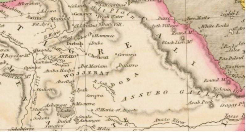
As for Dobe'a country, I would suggest changing the name of the country to Dobas/Doba.

Doba (Amharic: ዶባ, Afar: Dobaq) also known as the Country of Dobas was a historical Muslim region in central modern Ethiopia.
Dobe'a.png

Doba.png

 
  • 1
  • 1Like
Reactions:
Do we know if province goods change through out the time of the game?

it should not suddenly, but as with eu4 at a later stage certain things become more relevant like coal. I suggested a 2nd resource at least needs to be added to a province.
To enable more diverse economics and not discount a go tall strategy. Its simply far from unrealistic to give a coastal region lets say only olives when they have access to fishing. In my game design you would see 1st fishing 2nd olives.
 
I was wondering ... an old name for Djibouti when it was a colony was territory of Afars and issas.
there are Afars , but i don't know if issas were a minority , or they simply moved there after 1337?
 

Attachments

  • territoire-francais-des-afars-et-issas-carte-djibouti-moderne-ca-1976-2hbt1gd.jpg
    territoire-francais-des-afars-et-issas-carte-djibouti-moderne-ca-1976-2hbt1gd.jpg
    83,9 KB · Views: 0
Possible Religious Additions Part 3 (Visualization + Some Changes and Additions):

Cwezi-Kubandwa:
I saw this religion being brought up by arkh4ngelsk, and I have to agree that it is a good candidate to be added, but I don’t think it should take up a majority of the great lakes region as its extent in 1337 was largely unknown. Instead it should be present predominantly in western Uganda with its extent being from Lake Albert, going south, with less homogenous and more minority pops throughout the largest extent of the border of the empire of Kitara.

Areas with a significant majority should be the following locations:
  • Heartland of the Kitara (and later Bunyoro): Pawir, Kiboro, Kibengo, Rugombe, Bigo Bya Mngenyi, Isinguro, Bugara, Buzanga
Areas with a sizable population:
  • Neighboring locations of the heartland of the Kitara, under consistent influence for a decent amount of time by game start: Ndorwa, Haya, Katwe, Buddu, Rubaga
Areas with a large minority population:
  • Locations under former control of Kitara, not being held for too long: North Buganda, Buganda, Busoga, Lango, Batete, Pere
Areas with a small minority population (<5%):
  • Location wasn’t fully controlled, and not for long either: Nduga

Changes in other religions distributions:
  • Waaqeffannaa minority pops have been extended in Ajuran as they were likely underrepresented in my original proposal, considering that they had much less severe policies with Islamization than other states around them.
  • Adroa-Adro is having Pawir moved from a sizable population location into a large minority location, as the information I have found out about Cwezi-Kubandwa suggests it was smaller in Pawir than I originally believed.
  • Given the preservation of the temples in Tigray for the Almaqahism/Sabaeanism religion, I may have underestimated the community that existed to protect these temples and I am thus increasing their numbers in certain locations slightly. (the inclusion of this one in and of itself is already a long shot, but it is possible that they still existed by 1337, just isn’t likely and there's no historical mention of them past the 6th century)
  • Various other small tweaks

Abrahamic faiths wont be present in this proposal at all, so the islamic minorities in the Kushite areas wont be shown, but they are there in reality.
Screenshot (47).png


Sorry for the poor quality, but MS paint isn't too good at preserving it and not overlaying it with the religion map mode, its just easier for me to do it and MS paint wasn't very cooperative.

A filled in area means that the religion is a majority in that location, pretty much anywhere between 50% and 100% of the population follows that religion. Thicker lines mean a significant minority (>10%) and the smaller lines show an insignificant minority (<10%).

Comparing this map to the religion map mode, a decent portion of the animist blob is filled in, only being heavily present in the Bahr el Ghazal, Equatoria, Simivu, Mara, North Turkana, South Turkana provinces, which is a good improvement over the 20+ provinces with "Animist" religion. Additionally, the Miaphysite religion should probably be split into an Armenian Apostolic church and Ethiopian Tewahedo church given how much they would diverge throughout the game's timeline. I understand they are currently represented as separate IOs with separate patriarchies, but at some point in the game they should officially diverge from one another via event if they are not differentiated at game start.

Nonetheless, please do criticize this proposal. Most borders here are approximations of where they more or less likely were, but I probably made some mistakes along the way so do help me improve this proposal based on what little information can be gathered about these religions.

Edit: I forgot to add this, but Yambio could get a small minority of Khonvoumist pops because of the presence of a different group of Pygmies, not too distantly related to the ones in Kivu.
 

Attachments

  • Thingy.jpg
    Thingy.jpg
    93,5 KB · Views: 0
Last edited:
  • 6Like
  • 4
  • 2
Reactions:
Amazing map especially with how they included most of northern somalia with ifat

The attention to detail is amazing

My only gripes would be the representation of somalis in the city harar

Giving the name harari for a culture group is like giving Japanese in Tokyo a different culture group or French in Paris are Parisians instead of just French

Also the bale and shewa region were places that were fought over between the ethiopian and ifat states and bale was famously known for having a mostly somali population due to islamization of the land

Even the name shiekh hussein was historically somali who came from merca a coastal city in the Sultanate of Mogadishu (ajuraan)

Regardless the map is amazing, looking forward to seeing the major wars in the horn and between ifat and abyssinia and of course the later adal

Also mogadishu sultanate at this point in time had such an amazing impact on trade in the indian ocean even with china, would love to see this in game especially the later ming treasure fleets

Here's the evidence for the harar claims as the "harari" term is mostly a city term

No different to a londoner or a new Yorker, seems very wrong to simply give an entirely different culture group to one of the largest historical capitals of an almost Mono-ethnic state

[Btw the harari term being mostly a 19th century creation should be emphasized, it's a modern term due to the recent diversity of the city due to urbanization and migration]


THE INHABITANTS OF HARAR WERE SOMALI

"The inhabitants of Harrar form the most curious of these populations. The Harraris belong to the Somali race; but they surpass these with the superiority that populations settled in cities and devoted to commerce have... No European has yet visited Harrar. The information I gathered about the city and its curious inhabitants was given to me by the representative that the Emir of Harrar sent to the king of Choa to protect the interests of those of his subjects who trade with Abyssinia. This envoy came to visit me.."
- Around the middle of the 1800s, french explorer Charles E. Xavier Rochet d'Héricourt visited the kingdom of Shoa, there he met a Harari envoy of the Emir of Harar who told him many interesting things about Harar, the inhabitants are of the Somali race but they surpass the average Somalis of the benefits that a settled population has.


[MAP OF THE ETHNICITIES OF AFRICA]
"Check map below"
- Dimitrie Ghica-Comănești prince of Romania, romanian nobleman and royal adviser, but he was also an ambitious explorer who visited the horn of Africa with his father. They together ventured deeper than any European in the Horn of Africa between 1894 and 1895 crossing today's Ethiopia, Djibouti, and Somalia, where they made notable geographical explorations and natural history discoveries. This is a map he made according to the info he gathered during his expeditions [check the map below], as you can see in this map, Harar is somali territory. As of when I'm writing this post, he has a pretty good Wikipedia page you can check out to know more about him.

(I've added some extra sources for a recent reply to this comment)
 

Attachments

  • 20240304_003952.png
    20240304_003952.png
    515,3 KB · Views: 0
  • 20240304_003924.png
    20240304_003924.png
    826 KB · Views: 0
  • yJpWnS0.png
    yJpWnS0.png
    57,7 KB · Views: 0
  • IMG_20231203_203911.png
    IMG_20231203_203911.png
    90,6 KB · Views: 0
  • 1867_Horn_of_Africa_map.png
    1867_Horn_of_Africa_map.png
    926,9 KB · Views: 0
  • Screenshot_20240828_093047.jpg
    Screenshot_20240828_093047.jpg
    664 KB · Views: 0
  • Screenshot_20240828_093114.jpg
    Screenshot_20240828_093114.jpg
    360,2 KB · Views: 0
  • Screenshot_20240828_090300.jpg
    Screenshot_20240828_090300.jpg
    306,6 KB · Views: 0
  • Screenshot_20240828_092550.jpg
    Screenshot_20240828_092550.jpg
    313,4 KB · Views: 0
  • Screenshot_20240828_090522.jpg
    Screenshot_20240828_090522.jpg
    447,3 KB · Views: 0
  • Screenshot_20240828_090444.jpg
    Screenshot_20240828_090444.jpg
    691,2 KB · Views: 0
Last edited:
  • 6Like
  • 2
  • 1
Reactions: