• We have updated our Community Code of Conduct. Please read through the new rules for the forum that are an integral part of Paradox Interactive’s User Agreement.

Tinto Maps #17 - 6th of September 2024 - Arabia

Hello everyone, and welcome to one more developer diary for map lovers! This is the second this week, after the review of Poland, Ruthenia, and the Baltic. Hurray!

Today we will be taking a look at the lands of Arabia! So let’s start, without further ado:

Countries:
Countries.png

Colored Wastelands.png
This week, we have two country maps: one without colored wastelands for clarity, and one with them under the spoiler button. You might also wonder why there isn’t a third one with the Societies of Pops for the region. Well, that’s because Project Caesar has several layers to portray the simulation of a believable world (if you remember, one of our design pillars). A couple of weeks we presented the Societies of Pops as a new type of country, but if you go back to Tinto Talks #4, the Government Overview, Johan mentioned the different types of governments, which now you know are for Settled Countries. One of them is Tribal, which we think makes for a good representation of the most complex and organized tribal societies, which have some estate-like features while keeping some other tribal features.

Therefore, the way we’ve decided that fits better to portray the simulation of the Arabian Peninsula is having a divide between those countries that are Monarchies (Mecca, Yemen, Oman, Ormus, and the Jarwanids), and those that are Tribal (the rest of them). An interesting feature of the latter is that their lands will be full of Tribesmen pops, making the Tribal estate the most important one to manage. As a final note, I’d like you to understand that this is our interpretation for the simulation of the game, although it might not be the only one (as it happened with the discussions about which European countries should be decentralized with several subjects, and which shouldn’t). The good news regarding this is that we will be open to feedback and making changes, as usual; but also, that this setup can easily be changed through the script of the game, thus making it completely moddable after the game is released; so there could potentially be mods making inner Arabia covered by Societies of Pops instead of Tribal Settled countries, if you don’t like/agree with our interpretation, or just prefer it to be different.


Dynasties:
Dynasties.png

Among the dynasties of the region, you might find some old acquaintances, such as the Rasulids of Yemen or the Nabhani of Oman, while also having a bunch of new ones. And not a week without a bug, of course: the ‘al-Al’ prefix is an error, as those dynasties are using a locative, which is mixed with a second one, from the location; we will have that fixed, then.

Locations:
Locations.png

Locations 2.png

Locations 3.png

Locations 4.png
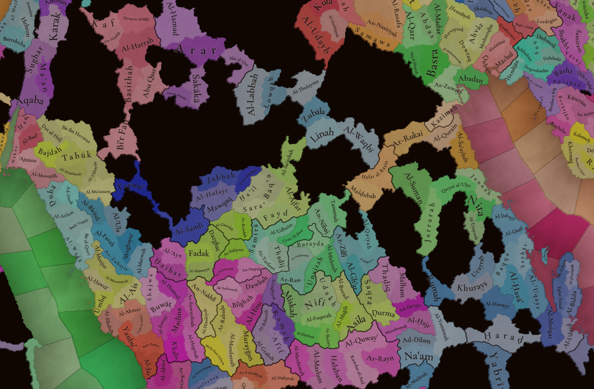
The locations of the region, with more detailed maps under the spoiler button for three different sections (Northern and Central Arabia, Southern Arabia, and Eastern Arabia).

Provinces:
Provinces.png


Areas:
Areas.png


Terrain:
Climate.png

Topography.png

Vegetation.png

You might notice that most of Arabia is an arid, desertic plateau. The only exception to this is some fertile mountain valleys in Yemen, which was known as Eudaimon Arabia/Arabia Felix for a reason.

Natural Harbors:
Harbors.png


Cultures:
Cultures.png

The cultural division of the region is quite interesting, as it’s divided into several Arabic-speaking people. And for those that might wonder, yes, Socotra has its own culture, Soqotri. We still have to add some minorities here and there, though, so we will take the opportunity to do it during the map review.

Religions:
Religions.png

The religious division of Arabia is also interesting, having Sunni, Shiite, and Ibady majorities spread across the peninsula. We have yet to address the minorities, which were not ready for the Tinto Maps, so we will show what that looks like on the map, and review as well. By the way, we might do some work in the coming weeks regarding Islam, and one of the things that I think we may tweak is the coloring, as Ibadi is too similar to Shiite; so I think that this might be a good opportunity to ask for your preferences about the coloring of the different branches of the Islamic faith.

Raw Materials:
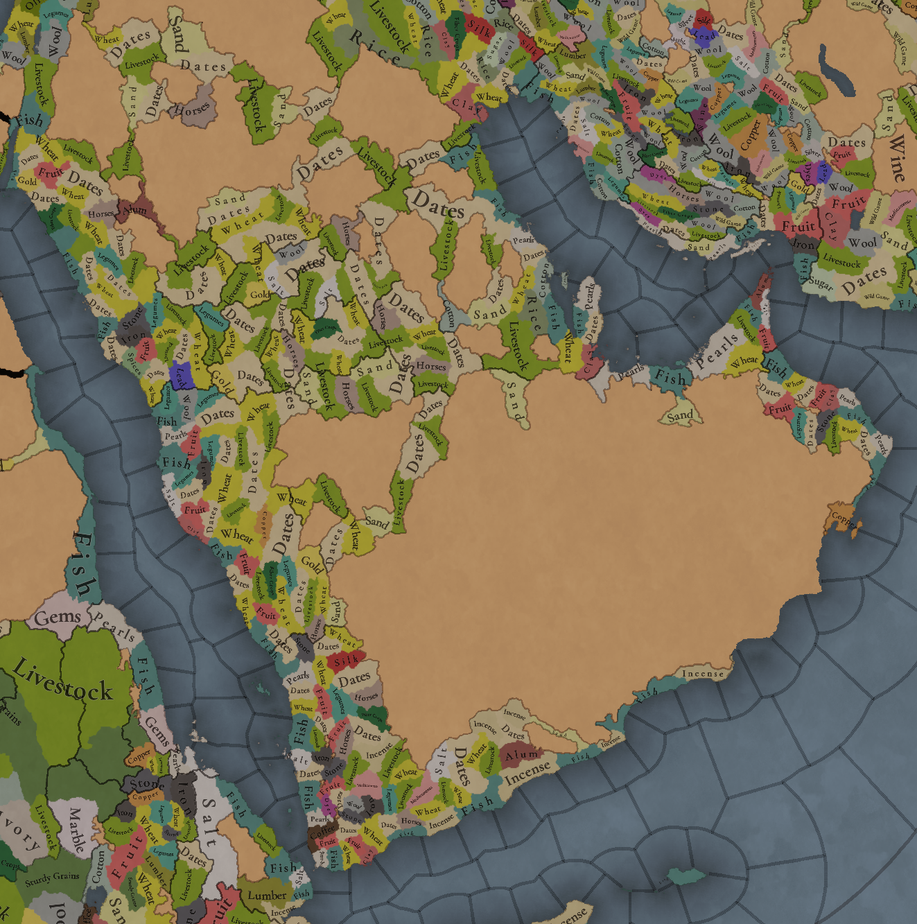
Raw Materials.png

Dates, livestock, horses, and some wheat and sand make for a healthy economy if you’re a Tribal country, I guess? Jokes aside, the desertic lands of Northern and Central Arabia have a more simple resource distribution, while Yemen and Oman, on the other hand, have quite rich resources, such as Pearls, Alum, Copper, Dyes, Silk, and Coffee (who doesn’t like a good mocha?).

Markets:
Markets.png

There are five market centers present in this region: Mecca, Al-Hajar, Al-Hasa’, Hormoz, and ‘Adan. Coupled with the resources in the previous section, the control over ‘Adan and Hormoz will be strategically relevant, as it was historically.

Population:
Population.png

Population 2.png

Population 3.png

Population 4.png
This week there aren’t (almost) issues with the population of the region, so we’re able to show it to you. The entire region has around 4.5M pops, which are unevenly distributed; Yemen has 1.6M, and Mecca 776K, making for more than half of the total, while a good chunk of it belongs to the Mamluks (that control all the area around Madina.

And that’s all for this week! For the next one, I have good news: we have finished the feedback review of Anatolia, and therefore I’ll post it on Monday! That way it will make for a week without a Tinto Talks more bearable. And on Friday, there will be maps for a new region, Iran and the Caucasus! See you!
 
  • 141Like
  • 33Love
  • 3
  • 3
  • 2
Reactions:
Yes! Jeddah was a major harbor for Indian Ocean trade network. It’s also an important port to access Makkah for pilgrimage (Hajj).

Hajj was an important source of income for the local ruler of Hejaz (or Makkah specifically) since they taxed gifts that pilgrims brought to the locals and taxed imported goods since it was common for pilgrims to bring goods to trade before/after the pilgrimage.

Unfortunately most of the sources i came across are in Arabic (i’m from Jeddah!) and i’m not sure if sharing them is acceptable.
Do you know any details who claimed to rule and who really ruled the region Midian (Northern Hejaz)?
 
PORTS! PORTS! PORTS!

I was finally able to go to my local college library and look at a copy of "The Ports of Oman," which doesn't seem to exist digitally. So now follows a lot of text about the ports of Oman (and a little on surrounding regions).

It's important to remember (and as this book reiterates over and over, haha) that the existence of a major harbor does NOT necessarily mean that the site is a good natural harbor, or even the best natural harbor in the region. There are a lot of other factors also involved in what places actually end up being used as major harbors. I encourage people who know a major port existed somewhere to do follow up research to examine if that location is indeed a good natural harbor or just had other advantages.

Overview of my suggestions, based on this source:
  • Jeddah should have low or no suitability, despite its importance as a port, but this is based on limited evidence and could be easily rebutted by further sources
  • Dufar and Raysut should have no suitability or low suitability depending on the criteria and strictness. Also Dufar should be renamed to either al-Baleed, Zafar, or Salalah, as Dhofar seems to refer to the entire region, including Raysut.
  • Qalhat and Sur should both have some suitability
  • Muscat should have high but not max suitability
  • Sohar should remain at zero suitability

Jeddah

As you might expect, there's not a ton on Jeddah here. However there is one section that would seem to indicate that Jeddah should not be given very good natural harbor characteristics.
Jiddah, for example, flourished from its location halfway up or down the Red Sea and from providing access to the Holy City of Makkah. ... Yet neither of these cities had favorable geographical characteristics. ... In 1183 CE..., a pilgrim wrote of the entry to Jiddah: "The entry into it is difficult to achieve because of the many reefs and the windings. We observed the art of these captains and the mariners in the handling of their ships through the reefs. It was truly marvelous. They would enter the narrow channels and manage their way through them as a cavalier manages a horse that is light on the bridle and tractable. They came through in a wonderful manner that can not be described ... ." (Ports of Oman pg. 18-19)
People who have sources on Saudi Arabia can maybe look in those for more detail supporting or refuting that assertion.

Dhofar region (Zafar/al-Baleed/Raysut/Salalah)

While these were at various times important ports for Indian Ocean trade, it seems that the ocean geography is not particularly amazing, aside from a few areas with nice bays, and the ports were largely enabled by the construction of large jetties. There are numerous references to the availability of freshwater in the area as being important for a harbor (and became more important in the PC era as trade centralized around bigger ships in fewer ports), so the natural harbor rating may depend on whether that is one of the criteria used by Tinto.
"Raysut served as a major trade emporium [this is discussing a time period before PC] due to its magnificent bay, high cliffs protecting it from the southwest monsoon, and its location on the large, freshwater Wadi Adhnoib." (Ports of Oman pg. 65)
During this long period [from the Iron Age to the Abbasid period], [the coastal sites] were usually modest in size and were found in protected bays safe for navigation, anchorage, and resupply. ... In the later Middle Islamic period, the pattern changed again due to a much-larger-volume traffic in goods, which was consolidated in larger ports with bigger ships. Thus, due to greater and more reliable water sources, al-Baleed became preeminent over the region... Water demands for such large settlements preempted the need for natural anchorages, as witnessed by the growth of Sirah, Sohar, Zahar, and Shihr - all in roadsteads. These are exemplified by the appearance of buoy anchors (mooring stones) well offshore, as mentioned by Ibn Battuta." (Ports of Oman, pg 66-67)
al-Baleed is essentially within modern-day Salalah, which is currently called Dufar on the map but probably should be renamed.

To sum up this region, I think it'd be fair to give it 0 natural harbor suitability. If you want to be generous you could perhaps give Raysut a very small amount to reflect its "magnificent bay." If freshwater sources are considered in the criteria you could give al-Baleed/Zafar/Salalah/Dufar (whatever you call it) a very small amount, but it should be limited by the poor maritime geography.

Qalhat

This was, for a few centuries (including, notably for PC, in 1337), the "most important of Omani ports" until it's decline due to an earthquake (perhaps helped along by the Portuguese; perhaps also helped along by its anchorage silting up). The state of a natural harbor at Qalhat is a little unclear. It seems that it currently is not great, but may have at its peak (again, this includes 1337) had a protected, if somewhat small, natural anchorage in the mouth of a wadi, which in the present day is entirely silted up.

But why did Qalhat, with only a small khwar (inlet) and an extremely isolated position on a rugged coast, prosper during the thirteenth to sixteenth centuries. (Ports of Oman pg. 117)
Qalhat is backed by mountains and split by the Wadi Hilm which may have provided an anchorage up until about the fifteenth or sixteenth century. Miles [British army officer S. B. Miles, who served in the Arab world in the late 19th century] reported that the coast is steep-to, going to depths of ten to fifteen fathoms (18 to 27 meters) within 100 yards offshore. (Ports of Oman)
Ibn Battuta and Marco Polo both remark on the "harbor" at Qalhat. Many scholars have identified the inlet at the mouth of Wadi Hilm on the northern side of ancient Qalhat with this harbor [see image in spoiler below]. This inlet is largely silted up, and today a sandbar usually blocks the entrance from the sea. It was believed, however, that in the past before the inlet became silted, the inlet would have provided an ideal anchorage for vessels. Miles says that prior to the alleged late-fifteenth-century earthquake, the deep ravine which divides the city formed the harbor, up which vessels could ascend for half a mile and anchor abreast of the town, but it is now so choked that only the smallest boats can enter it. This discovery or a short length of modern plastic cordage... in the wadi suggests that significant modern deposition is occurring and reinforces the theory that the original wadi basin may have been much larger and deeper....

Figure 10 [in the spoiler below] illustrates the possible outline of the wadi prior to possible silting over the centuries.... The arrow indicates a distance of half a mile, the distance from the wadi mouth that Miles mentioned where ships could moor. It should be remembered that a position half a mile into the wadi is the position in the harbor mentioned by Ibn Battuta beneath the Bibi Maryam mausoleum.... it may well have been possible that the mouth of the wadi served as a harbor in the past. This may in part explain the early success of Qalhat as a major trade entrepôt. (Ports of Oman pg. 123-124)
Screenshot 2024-09-11 190104.png
Based on the arguments that the wadi formerly provided a well-protected anchorage right next to town, I would suggest that Qalhat be given some amount of natural harbor suitability.

Sur

Sur seems to have become a somewhat busy port for a period after Qalhat's decline. In terms of natural harbors, it seems... alright? Perhaps somewhat similar to Qalhat where a decent natural harbor became heavily silted up over time.
... Sur, with an extensive although shallow natural harbor... (Ports of Oman pg. 117)
Miles... wrote extensively about Sur, including this brief description: "Sur is situated on a tidal wadi creek forming a large through shallow body of water that surrounds Sur on three sides.... The harbour is formed by a creek running up tortuously some distance, half encircling the town and is deep enough for the largest bughlas, which can be built and launched and laud up in ordinary during the winter monsoon. (Ports of Oman pg. 129)
Miles states that the creek was deep enough "for the largest bughlas" but Sheriff disagrees: "The creek at Sur was shallow, vast tracks of the khor drying at low tide." Sur had to use the neihboring khwar at Jarama for its seagoing dhows due to sedimentation in the khwar at Sur. (Ports of Oman pg. 129-130)
These flats have yielded cores of sediment up to seven meters deep, demonstrating considerable silt deposition over a long period of time. (Ports of Oman pg. 130)
If you buy the silting argument for Qalhat it seems acceptable for Sur as well, and it could be given some amount of natural harbor suitability.

Muscat/Mutrah

While they didn't become important ports until quite late, they have excellent natural harbors.
In the chapter on the conquest of Muscat, [Afonso de] Albuquerque stresses the importance of the town for his overall strategy: "... the principle reason [to attack Muscat] was that the place was very well supplied with necessaries, and had a harbour excellently adapted to the protection of ships passing that way...

At the end of this chapter we find a description of Muscat before the destruction: "Muscat is a large and very populous city... The harbour is small, shaped like a horse-shoe, and sheltered from every wind; it is the principal entrepôt of the kingdom of Ormuz..." (Ports of Oman pg. 143)
Screenshot 2024-09-11 194032.png
Carsten Niebuhr visited Muscat in January 1765... Following some introductory information: "... It stands at one end of a beautiful plain, besides a small gulph, encompassed with steep rocks, forming an excellent harbor, in which the largest vessels may find shelter." (Ports of Oman pg. 145)
Qalhat was the second capital of the kingdom of Hormuz and the center of a far-reaching sea trade network... The Portuguese destroyed Qalhat and made Muscat their principal harbor on the coast of Oman. One of the reasons for this was the deeper water at Muscat, which allowed the heavier Portuguese ships to enter safely. (Ports of Oman pg. 149-150)
Muscat and Mutrah have been major ports in Oman for at least the last five hundred years. Both harbors have large and well-protected anchorages that provide appropriate shelter for visiting ships depending on the predominant wind at the time. (Ports of Oman pg. 357)
Muscat's natural advantages as a harbor are its protection from both sea and land. the presence of supplies of sweet water, and the depth of its anchorage. The harbor is about one mile wide with depths of nine to 13 fathoms at the entrance.... But the harbor also exhibits some drawbacks. The opening to the north leaves it vulnerable to the shamal, the northerly wind that blows most of the year except in winter, which drives thee sea directly into the harbor.... The harbor is also unprotected from the heavy seas generated by the nashi, the winter northeasterlies from off the Iranian and Makran coasts.... Anchorage at Matrah [=Mutrah] provided protection from the shamal, although not from the nashi. It's utility as a harbor, however, was hampered by the shallow, sandy beach abutting the town. (Muscat as a Port City pg. 155)
Muscat should clearly be given good natural harbor suitability, but not maxed.

Sohar

Was a busy port at times. It sucks, geographically. Give it a 0.
Sohar, despite lacking any natural harbor whatsoever, retained its preeminent position because it was well known as a port from prehistoric times... (Ports of Oman pg. 117)
As Sohar lacked the natural harbor of Mutrah, a large breakwater for the port had to be constructed. (Ports of Oman pg. 361)

The Southern Batinah Coast region

This is the coastline from Seeb to Saham. Doesn't seem great. Sounds like there's a few somewhat tolerable harbors but since the maps of other regions don't seem to be giving harbor suitability to every spot that has a hint of a natural harbor it seems fine to leave it at 0. If I am wrong about the strictness of the criteria here, or if it relaxes, there maybe should be some small ratings being given out here.
The Batinah coast is long and straight and has very few natural harbors. Most fishing boats were, and still are, winched up onto the beach.... However, there are a number of places along the Batinah coast that form natural harbors, representing a sector of the sea surface that is protected in a natural or artificial way and can be used as a anchorage for ships and a a place to load and unload goods. (Ports of Oman pg. 160)
63.jpg

Sources:

Abdulrahman Al Salimi and Eric Staples, eds. The Ports of Oman is the main source and has tons of good information. It doesn't seem to have any ebook version that I could find, hence me having to go to a university library.

J. E. Peterson, "Muscat as a Port City", in The Gulf in Modern Times: Peoples, Ports and History has lots of information about Muscat, and backs up its characterization as having an excellent protected natural harbor (available on author's website).

Also note William Facey, "The Red Sea: the wind regime and location of ports" which is mostly about the prevailing winds of the region and the relation of that to certain ports. I'm not sure how closely that connects to PC's natural harbor map but there might be some nuggets in there.
 
Last edited:
  • 10Like
  • 6
  • 3
Reactions:
Natural Harbor Capacity Proposal

Based on the references I am replying to, which people seemed to find helpful, I created an in-game proposal for the Persian Gulf NHC levels. These will follow the metrics I have used for other proposals on the same topic:

Red: 0-5%
Orange: 5-10%
Yellow: 10-15%
Green: 15-20%
Bright Green: 25%+

View attachment 1186185
I said this in my big post but you can't just look at where ports exist and derive natural harbor maps from that, especially in places with few natural harbors and/or rugged or disconnected inland terrain. There are many alternate reasons a place might become a major port, such as historical use as a port, good connection to inland trade networks or production sites, suitability for habitation, defensiveness on the land side, political ownership, government funding or other support, political instability in other ports, destination of goods, or location on a major maritime trade route.

For example, you give Sohar a green rating, presumably due to it being a busy port, when every mention I've seen of it is about how the natural harbor sucks (or just plain doesn't exist) and it was nevertheless a busy port for a variety of other reasons.
 
  • 8Like
  • 5
Reactions:
Regarding Midin, I tried to look through some books online since i’m currently traveling.
I couldn’t find a specific name but most of what i found was related to pilgrimage route passing through the region. Al Maqrizi mentioned in his book that the Sultan (Mamluk) built and expanded roads and bridges over the area starting from Aila (modern day Eilat).
(I can’t reply to posts directly due to anti-spam)
 
Last edited:
PORTS! PORTS! PORTS!

I was finally able to go to my local college library and look at a copy of "The Ports of Oman," which doesn't seem to exist digitally. So now follows a lot of text about the ports of Oman (and a little on surrounding regions).

It's important to remember (and as this book reiterates over and over, haha) that the existence of a major harbor does NOT necessarily mean that the site is a good natural harbor, or even the best natural harbor in the region. There are a lot of other factors also involved in what places actually end up being used as major harbors. I encourage people who know a major port existed somewhere to do follow up research to examine if that location is indeed a good natural harbor or just had other advantages.

Overview of my suggestions, based on this source:
  • Jeddah should have low or no suitability, despite its importance as a port, but this is based on limited evidence and could be easily rebutted by further sources
  • Dufar and Raysut should have no suitability or low suitability depending on the criteria and strictness. Also Dufar should be renamed to either al-Baleed, Zafar, or Salalah, as Dhofar seems to refer to the entire region, including Raysut.
  • Qalhat and Sur should both have some suitability
  • Muscat should have high but not max suitability
  • Sohar should remain at zero suitability

Jeddah

As you might expect, there's not a ton on Jeddah here. However there is one section that would seem to indicate that Jeddah should not be given very good natural harbor characteristics.

People who have sources on Saudi Arabia can maybe look in those for more detail supporting or refuting that assertion.

Dhofar region (Zafar/al-Baleed/Raysut/Salalah)

While these were at various times important ports for Indian Ocean trade, it seems that the ocean geography is not particularly amazing, aside from a few areas with nice bays, and the ports were largely enabled by the construction of large jetties. There are numerous references to the availability of freshwater in the area as being important for a harbor (and became more important in the PC era as trade centralized around bigger ships in fewer ports), so the natural harbor rating may depend on whether that is one of the criteria used by Tinto.


al-Baleed is essentially within modern-day Salalah, which is currently called Dufar on the map but probably should be renamed.

To sum up this region, I think it'd be fair to give it 0 natural harbor suitability. If you want to be generous you could perhaps give Raysut a very small amount to reflect its "magnificent bay." If freshwater sources are considered in the criteria you could give al-Baleed/Zafar/Salalah/Dufar (whatever you call it) a very small amount, but it should be limited by the poor maritime geography.

Qalhat

This was, for a few centuries (including, notably for PC, in 1337), the "most important of Omani ports" until it's decline due to an earthquake (perhaps helped along by the Portuguese; perhaps also helped along by its anchorage silting up). The state of a natural harbor at Qalhat is a little unclear. It seems that it currently is not great, but may have at its peak (again, this includes 1337) had a protected, if somewhat small, natural anchorage in the mouth of a wadi, which in the present day is entirely silted up.


Based on the arguments that the wadi formerly provided a well-protected anchorage right next to town, I would suggest that Qalhat be given some amount of natural harbor suitability.

Sur

Sur seems to have become a somewhat busy port for a period after Qalhat's decline. In terms of natural harbors, it seems... alright? Perhaps somewhat similar to Qalhat where a decent natural harbor became heavily silted up over time.


If you buy the silting argument for Qalhat it seems acceptable for Sur as well, and it could be given some amount of natural harbor suitability.

Muscat/Mutrah

While they didn't become important ports until quite late, they have excellent natural harbors.


Muscat should clearly be given good natural harbor suitability, but not maxed.

Sohar

Was a busy port at times. It sucks, geographically. Give it a 0.


The Southern Batinah Coast region

This is the coastline from Seeb to Saham. Doesn't seem great. Sounds like there's a few somewhat tolerable harbors but since the maps of other regions don't seem to be giving harbor suitability to every spot that has a hint of a natural harbor it seems fine to leave it at 0. If I am wrong about the strictness of the criteria here, or if it relaxes, there maybe should be some small ratings being given out here.


Sources:

Abdulrahman Al Salimi and Eric Staples, eds. The Ports of Oman is the main source and has tons of good information. It doesn't seem to have any ebook version that I could find, hence me having to go to a university library.

J. E. Peterson, "Muscat as a Port City", in The Gulf in Modern Times: Peoples, Ports and History has lots of information about Muscat, and backs up its characterization as having an excellent protected natural harbor (available on author's website).

Also note William Facey, "The Red Sea: the wind regime and location of ports" which is mostly about the prevailing winds of the region and the relation of that to certain ports. I'm not sure how closely that connects to PC's natural harbor map but there might be some nuggets in there.

Additional info on Qalhat, from this journal, if you don't buy the silting argument there was another anchoring point on the eastern side of the city, in the central quarter:
Surface surveys and excavations held since 2008 now allow a fairly good understanding of the spatial organization of the city and its evolution. The site is located on a narrow triangular rocky plateau at the foot of the Jabal al‑Ḥajar al‑Sharqī, which is totally surrounded by the sea to the east, the mountain to the southwest and the high bank of the Wādī Hilm to the northwest (fig. 6). The plateau slightly slopes down from the foot of the mountain (at level about 40 m), ending at the seaside with a steep and inaccessible cliff about 10 m high, beaten by the waves at high tide. There is only in one place in the northern part of the plain where the ground reaches sea level, as a natural depression bordered by a small and sloppy pebble beach (fig. 7). This is the only place in the area where a boat may land, and it is furthermore protected by a sand spur at the mouth of the Wādī Hilm, which breaks the choppy sea. Underwater surveys led by T. Vosmer in 1998 showed that nearly all of the 27 medieval stone anchors detected were indeed located in front of this beach. The original settlement was situated there, in the depression and on the surrounding slopes.
img-3-small480.jpg


Also, it could be worth considering that the location of Sur in-game includes the Ras al-Hadd, which could have additional suitabalitiy.
 
Last edited:
  • 1Like
Reactions:
Regarding Jedda,
i’m referencing (كتاب السلوك لمعرفة دول الملوك ) written by Taqi Ad-Din Al-Maqrizi, a famous Egyptian historian who lived and recorded during Mamulk period.
In his book, he mentioned in several occasions the importance of Jedda.

Chapter 7: mentioned that in (828/Rabi I) traders used to port in Adan and don’t go beyond it. However, there was a trader, who usually sails from Calicut, that got mistreated in Adan so decided to dock in Jedda instead only to get his goods confiscated by the Sharif. Later, a Mamluk prince wrote to him to convince him to dock at Jedda again and promising to treat him well so he came again in 828 with 14 vessels. News of this encounter reached the Sultan and he was interested in the potential tax revenues from such merchants so he sent an Amir Al-Ashr (Mamulk rank) with around 100 mamluks to collect these taxes.
in Chapter 7: In (835/ Shawwal) News arrived from Makka that there were ships coming from China carrying musk, silk, and Chinaware docked in Adan and India and requested from the Sharif and Nazir (literal translation is Overseer) of Jedda to dock in Jedda since there were disturbances in Yemen. Both the Sharif & Nazir wrote to the Sultan asking for permission and pointed out how much money can be made if they’ve permitted to dock and then the sultan gave the permission.
Also in Chapter 7: In (838/Safar) in Hijri, the Mamulk sultan (at the time was Al-Ashraf Sayf Ad-Din Barsbay) ordered to tax Indian merchants at 10% and double that for Egyptian & Shami (Levantine) merchants in Jedda. Also, he ordered to confiscate all of Yemeni merchants’ goods but the Sharif wrote to the Sultan asking to reverse this policy. Al-Maqrizi mentioned that ever since, Jedda became a major mercantile port and made significant tax revenues for the Sultan and the position of Nazir of Jedda became a post appointed by the Sultanate.

These chronicles indicate that Jedda was an important harbor for merchants and generated significant tax revenues for the Mamulk Sultans and the Sharifs. It’s also worth mentioning that Adan (and Yemen overall) wasn’t under Mamluk authority and therefore they were interested in out-competing Adan using various means
 
  • 2
Reactions:
Regarding Jedda,
i’m referencing (كتاب السلوك لمعرفة دول الملوك ) written by Taqi Ad-Din Al-Maqrizi, a famous Egyptian historian who lived and recorded during Mamulk period.
In his book, he mentioned in several occasions the importance of Jedda.

Chapter 7: mentioned that in (828/Rabi I) traders used to port in Adan and don’t go beyond it. However, there was a trader, who usually sails from Calicut, that got mistreated in Adan so decided to dock in Jedda instead only to get his goods confiscated by the Sharif. Later, a Mamluk prince wrote to him to convince him to dock at Jedda again and promising to treat him well so he came again in 828 with 14 vessels. News of this encounter reached the Sultan and he was interested in the potential tax revenues from such merchants so he sent an Amir Al-Ashr (Mamulk rank) with around 100 mamluks to collect these taxes.
in Chapter 7: In (835/ Shawwal) News arrived from Makka that there were ships coming from China carrying musk, silk, and Chinaware docked in Adan and India and requested from the Sharif and Nazir (literal translation is Overseer) of Jedda to dock in Jedda since there were disturbances in Yemen. Both the Sharif & Nazir wrote to the Sultan asking for permission and pointed out how much money can be made if they’ve permitted to dock and then the sultan gave the permission.
Also in Chapter 7: In (838/Safar) in Hijri, the Mamulk sultan (at the time was Al-Ashraf Sayf Ad-Din Barsbay) ordered to tax Indian merchants at 10% and double that for Egyptian & Shami (Levantine) merchants in Jedda. Also, he ordered to confiscate all of Yemeni merchants’ goods but the Sharif wrote to the Sultan asking to reverse this policy. Al-Maqrizi mentioned that ever since, Jedda became a major mercantile port and made significant tax revenues for the Sultan and the position of Nazir of Jedda became a post appointed by the Sultanate.

These chronicles indicate that Jedda was an important harbor for merchants and generated significant tax revenues for the Mamulk Sultans and the Sharifs. It’s also worth mentioning that Adan (and Yemen overall) wasn’t under Mamluk authority and therefore they were interested in out-competing Adan using various means
That doesn’t say anything about Jeddah’s natural harbor suitability, however.
 
  • 1
Reactions:
I said this in my big post but you can't just look at where ports exist and derive natural harbor maps from that, especially in places with few natural harbors and/or rugged or disconnected inland terrain. There are many alternate reasons a place might become a major port, such as historical use as a port, good connection to inland trade networks or production sites, suitability for habitation, defensiveness on the land side, political ownership, government funding or other support, political instability in other ports, destination of goods, or location on a major maritime trade route.

For example, you give Sohar a green rating, presumably due to it being a busy port, when every mention I've seen of it is about how the natural harbor sucks (or just plain doesn't exist) and it was nevertheless a busy port for a variety of other reasons.
You are absolutely right. However, you should keep in mind that only what has potential can be realized. Where a port was built, there must have been a certain degree of natural suitability. Of course this degree of suitability cannot be solely determined by the historical significance resp. by the actual development of the port.

Similarly, it is incorrect to conclude that a location without a port has no natural suitability for a port.
 
Last edited:
PORTS! PORTS! PORTS!

Jeddah

As you might expect, there's not a ton on Jeddah here. However there is one section that would seem to indicate that Jeddah should not be given very good natural harbor characteristics.

People who have sources on Saudi Arabia can maybe look in those for more detail supporting or refuting that assertion.
From Handbook of Hejaz:

Jiddah, a walled town on a well-sheltered natural harbour, almost exactly half-way down the Red Sea coast. The entrance, through three lines of reefs, is, however, difficult. It possesses quays, landing piers, and sheds along the sea-front, and is the port of Mecca (54 miles by road, and slightly under 50, crowfly [87 km by road, 80 km straight-line]) and Tâ'if, and the main avenue of pilgrim access to Hejaz from the sea. Steamers, however, cannot approach within several hundred yards, and cargo must be discharged into dhows and lighters. The houses here, as at Yambo', are largely built of coralline. There are forts at the seaward angles of the walls, and three main gates and three posterns (sea-face); elsewhere the wall is strengthened.

The harbor was only suitable for dhows and lighters, which typically have a draft of 1 to 2 meters. Larger ships with a draft of more than 2 meters were unable to dock directly at the quays due to the limited water depth near the shore. Large sailing ships (e.g., frigates, galleons, ships of the line), with drafts of 4.5 to 7 meters, could still make use of the harbor by anchoring offshore—several hundred yards from the coast—and transferring their cargo onto smaller boats like dhows and lighters. However, this process of unloading cargo offshore and ferrying it to the harbor would have been inefficient and time-consuming, particularly for larger ships involved in extensive trade.

The natural protection provided by the reefs suggests that the waters were relatively calm.

Jeddah is described as a well-protected harbor, shielded by three lines of reefs and natural barriers. This offers good protection from storms and rough seas, which is crucial for the safety of ships. Smaller vessels operating within the harbor would have been well-protected from natural forces, making the area a reliable port for cargo transfers.

There is mention of quays, landing piers, and sheds along the coastline, which suggests there was enough space for basic infrastructure. Jeddah’s role as a significant pilgrim port indicates that there was sufficient space to accommodate the needs of pilgrims and the trade of smaller ships.

In summary, Jeddah was a suitable harbor for smaller vessels and offshore cargo transfers from larger ships, but its shallow depth and offshore anchoring requirements made it inefficient for large ships and extensive trade.

Edit:

Another source that confirms the statements above. The source is A History of Jeddah:

Page 40:
Its landing area, protected by coral reefs that were traversed by a canal and lagoons, offered shelter to small boats. Due to the wind regime in the Red Sea, ships from the Indian Ocean could sail about as far as Jeddah during the latter parts of the northeast monsoon. North of Jeddah, whereby persistent northerly winds and coral reefs were common, mostly smaller vessels which could sail closer to the coast were used.

Page 120:
Jeddah was protected by coral reefs which required vessels to anchor about one mile offshore and have passengers and cargo transported by small boats through a labyrinth of small passages to the shore.
Jeddah gained its significance due to its strategic proximity to Mecca, the center of pilgrimage. The town is situated at the end of the shortest route to the sea from Mecca. Its natural suitability as a port was secondary. The most sustained activity was commerce.
 
Last edited:
  • 4Like
Reactions:
That doesn’t say anything about Jeddah’s natural harbor suitability, however.
i’m not sure if the natural harbor suitability mentioned in the TT is based on geographical or historical considerations but i imagine these two things are correlated. How would an important historical port be not geographically suitable for ships?
However, if the main consideration was geographical features then i have no idea if Jedda was/is suitable.
 
i’m not sure if the natural harbor suitability mentioned in the TT is based on geographical or historical considerations but i imagine these two things are correlated.
I really hope it's geographical considerations and their goal is that the various mechanics that interact with ports can come together to reflect to some degree the historical considerations for where to place ports. If the natural harbor suitability is just a crutch to make ports pop up where they did historically and not actually reflecting the "natural" it would be disappointing, but that's not the impression I get.

Of course they're correlated (and, what's more, causative) because a natural harbor is a pretty nice place to put a port. But they're not in lockstep or deterministic.
How would an important historical port be not geographically suitable for ships?
By the any of the many other factors influencing port location being a stronger influence than the suitability of the maritime and coastal geography. Or by the complete lack of natural harbors in a region that needs a port.
 
  • 2Like
  • 1
Reactions:
Was Mecca not under Fatimid rule at this time?
I completely agree with the choice of having tribal states rather than SOP as there isn't that many different cultures. However, if you were to make it possible to have several SOPs of the same culture, then it would be interesting to show three layers of policies in the peninsula (kingdoms, tribal states and SOPs where each one fits best).
I like the concepts of having both SOPs and tribal states but right now it kinda feels like tribal states are here to fix the problem of not having several SOPs per culture.
Also having several SOPs per culture would make it possible for tribal states to become SOPs once they're conquered (however this mechanic would be even cooler if the players could play SOPs)
Strongly seconded.
 
  • 1Like
Reactions: