• We have updated our Community Code of Conduct. Please read through the new rules for the forum that are an integral part of Paradox Interactive’s User Agreement.

Tinto Maps #18 - 13th of September 2024 - Persia & Caucasus

Hello everyone, and welcome to one more Tinto Maps! Today we will be taking a look at Persia and the Caucasus! These are regions that encompass several modern-day countries and regions (Iraq, Iran, Balochistan, Afghanistan, Transoxiana, etc.), but for the sake of simplicity, we decided to name this DD this. Let’s start, without further ado!

Countries:
Countries.png

Colored Wastelands.png

The region is quite interesting in 1337, as there are plenty of countries to play with. The Ilkhanate is still alive, but in name only, the real power being hosted by the Jalayirids, who are overlords of some of their neighbors (the Chobanids, and the Eretnids). Other countries, such as Gurgan, the Kartids, and Muzaffarids are also struggling to get the hegemony over the region. Meanwhile, the strongest power in the Caucasus is the Kingdom of Georgia, although the region is also quite fragmented among different polities.

Ilkhanate.png

And speaking of the Ilkhanate, you may have wondered why isn’t it a unified tag… Well, it’s because we consider that it is clearly in decadence, having lost any grasp of authority over the provinces, so the best way of portraying it is through an International Organization. What we can see in this mapmode is that there are two pretenders to get the power, the Jalayarids and Gurgan, with the other countries still being formally part of it. I won’t talk more today about how it works and its features, but I’ll just say that there are two clear fates for the Ilkhanate: being dissolved, as historically happened, or being restored in full power as a unified country.

Dynasties:
Dynasties.png

Not much to say today about the dynasties, as they’re akin to the country names, in most cases. Well, you might wonder which one is the yellow one, ruling over Gurgan… That country is ruled by the Borgijin, heirs of Genghis Khan. Now you get the full picture of their rule over the Ilkhanate being challenged by the Jalayirids, I think…

Locations:
Locations.png

Location 2.png

Locations 3.png

Locations 4.png

Locations 5.png


Provinces:
Provinces.png


Areas:
Areas.png


Terrain:
Climate.png

Topography.png

Vegetation.png

We’re back to a region with lots of different climates, topography, and vegetation. This will make it very unique, gameplay and looking-wise.

Harbors:
Harbor.png

You might notice that there are ports in the Caspian Sea… Because, well, it’s considered a sea in our game, so there can be ships and navies over it.

Cultures:
Cultures.png

There's quite a lot of cultural division throughout the region... The Caucasus is, well, the Caucasus, divided among lots of different people. Then we have the Iraqi and Kurdish in Iraq, Persian and a number of other cultures in Iran, Baloch in Balochistan, Afghan in Afghanistan, and Khorasani, Turkmen, Khorezm, Hazara, and Tajiks, among others, in Khorasan and Transoxiana.

Religions:
Religion.png

Another interesting religious situation. Orthodox is the main religion in Georgia, and Miaphysitism in Armenia, with other confessions spread here and there throughout the Caucasus (Khabzeism, and three 'Pagan' confessions, Karachay-Balkar, Vainakh, and Lezgin). Then Iraq is divided among Sunni, to the north, and Shiism, to the south. And Iran is in an interesting situation, having a Sunni majority, but with some important Shiite pockets here and there. And Zoroastrianism, of course. It was not trivial to properly portray them, as we don't have good data for the 14th century. So what we did was some calculations, between sources that tell that there was still a majority as late as the 11th century, and the religion becoming severely reduced by the 16th century. Therefore, we decided to go with 20% of the population as a general rule of thumb; however, we're quite open to feedback over this matter.

Raw Materials:
Raw Materials.png

This region is full of rich resources, in stark contrast to the one we showed last week, Arabia. There are a couple of bugs on this mapmode that you might spot, I think.

Markets:
Markets.png

This region has several markets: Tabriz, Baghdad, Esfahan, Hormuz, Nishapur, and Zaranj., This will make for regionally fragmented-but-integrated economies (that is, good market access everyhwere, but with regionally diverging economies).

Population:
Population.png

Population 2.png

Population 3.png

Population 4.png

Population 5.png

The total population of the region is around 9M, taking into account all the different areas that we’re showing today. That is divided into about 4.5M in Iran, 2M in Iraq, 1.5M in the Caucasus, and around 1.5M in Transoxiana.

And that’s all for today! Next Friday we will be taking a look at India! Yes, in its entirety; we think that it is the best way to do it, although we’ll talk more about it next week. Another change, only for next week: the DD will be published at 10:00 instead of the regular 15:00, as I won’t be available in the afternoon to reply. Letting you know so there’s a proper wow-pole-run, yes. See you!
 

Attachments

  • Religion.png
    Religion.png
    3,2 MB · Views: 0
  • Cultures.png
    Cultures.png
    3,1 MB · Views: 0
  • 86Love
  • 84Like
  • 5
  • 3
  • 1Haha
  • 1
Reactions:
There is no such thing as "afghan culture or afghan people" in the 1300's. if you have decided to split it in 3 so you have hazara and tajik then just remove "afghan" and replace it with pashtun since that is obsiosly what you mean by "afghan"
1726261645879.png


yes there was a thing called afghan peoples since the 900s and even earlier if we go to persian and greek sources αβαγανο (abagano)
Epigonoï - Aphigonoï (Afigani)

so yes how about a few clicks before you say "there is no such thing" ?
 
  • 5
  • 2
Reactions:
Also, why on earth is all of Transoxiana Sunni without any religious minority? The Chaghatai Khanate converted to Islam only in 1326, and it didn't even stick! Merv is the seat of a Christian archbishopric, and in two years you have the execution of six Franciscan friars in Almaliq.

Per my suggestion above, the top-level rule of the Chaghatai Khanate should be Sunni (as should the state), but most of their subjects are either Tengri or Buddhist. The Barlas are a notable exception.
 
Last edited:
  • 8Like
  • 7
  • 1
Reactions:
By the way, all the "o"s in Uzbek names are a recent phonological development of Uzbek under Tajik influence and is anachronistic here. All of it should be "a" for period accuracy, as it is in all other Turkic languages that retain their vowel harmony. e.g. Tashkent rather than Toshkent.
 
  • 9Like
  • 3
  • 1
Reactions:
I would actually go further than what my suggestion currently is: I would say that the Chaghatai Ulus IO should already exist. The Chaghatai Khanate would be the "leader" of that IO (and have nominal ruling over all the various tribal and non-tribal entities I listed off). However, any tribal leader (historically the Qara'unas) can wage war against the current leader to boot them out and install their own puppet khan to rule the western half of the Chaghatai Khanate instead. The current Chaghatai Khans can attempt to reassert their authority over the western half (which was already spiraling out of control since 1334; their rule was only nominal in 1337 and in a decade not even that) and absorb all the tribes of the western half into their state, while the western half can instead unify into an empire of its own (historically under Timur).

In the event of the western half unifying without rule by the eastern half, the eastern half should be renamed to Moghulistan instead of Chaghatai Khanate. Or do the rename in the event that one of the tribes of the eastern half manages to take over in the east (historically the Dughlats).
 
Last edited:
  • 11
  • 4Like
  • 1
Reactions:
Also, as one last bit of emphasis, the succession of the Barlas was not always father-to-son. Rather, successorship went between several different branches (which acted together as a political unit, rather than against each other compared to the Jalayirs or Suldus). For instance, the previous ruler of the Barlas prior to Timur was Hajji Beg, who was from a different line.

So, for the sake of having Timur show up, you don't have to do anything all that special. Just have the heirs of the Barlas tribe be random rather than direct inheritance of father-to-son, and set it so that if the year is after 1355 and Timur hasn't ruled yet, that the next successor of the Barlas is Timur. Easy peasy. Does mean that a player might get stuck waiting around for their current ruler to die; maybe there can be an event for Timur to take over or something if it's taking too long. Historically there was also Tughlugh Timur invading repeatedly which prompted his death, but we can't always count on those things.

Or if you want to go especially crazy with it, you'd actually represent all 5 lines of the Barlas and have successorship be random between those five, but I think that's way too much detail for a system that is mostly in place (as far as the game is concerned) to get Timur on the throne.

Also Amir Husayn should similarly wind up succeeding as ruler of the Qara'unas at around the same time. Add in some challenge so that you can't just steamroll everyone else as Timur, by having the Qara'unas under a powerful ruler themselves.
 
Last edited:
  • 5Like
  • 1
  • 1
Reactions:
I checked locations names of mostly Armenian Highlands area and some neighboring locations. This post is continuation of the previous one, which is centered around Anatolia. Many locations I drawed as "checked" can be found on that post, I'll write the newly checked ones here.

The sources and methodology is same as my previous post. (I'll link it below.)

Locations I currently checked:

1000324179.png


Sutayid state were Mongol originated, idk which culture you guys will choose for them but I go with Turkish names on locations since probably there was little to none Mongolic names for areas they control and probably they used local names. Also even Sutayids were controlling those areas, there are still Turkic tribes' presence in many areas and not so much later they will fall and Turks will reconquer those locations in history and probably what would happen in game at most times.


Amadiya province:

Amadiya > İmadiye (Turkish name, Sutayids controlling it)

Başkale > Albak

Zakho > Zaho


Bitlis province:

Bahçesaray > Müküs (it became Bahçesaray in Turkey)

Çatak > Şatak (it became Çatak in 1943)


Van province:

Hoşap > Hoşab


Malazgirt province:

Hasankale (Turkish and given in Ottomans) > Paseank (Armenian, Armenia controls it)

Malazgirt > Malazgird

Tekman > Tatos (Armenian)

Tutak > Antab


Ḫōy province:

Bayazıt > Bayazid

Bayazıt named after Bayazid, brother of Sultan Ahmed Celayir (1382-1410). Which is after 1337, but before than we only got antique Armenian name of the town. So I think we need to use Bayazıt. Though Bayazıt is Turkish (it should be Bayazıd in Turkish though in my opinion), if you make Chobanids as Mongolic or Persian, then rename it to Bayazid.

I didn't check other locations in the province.


Yerevan province:

Igdir > Tsolakert

Trivia about Igdir; there was an antique city of Tsolakert, which was mentioned until the 5th century at the latest, according to Nişanyan (Turkish-Armenian linguist, historian). Iğdır/Igdir is a Turkish name. Spanish envoy Ruy Gonzalez de Clavijo writes the name of the castle in the place as Iğdır/Igdir castle in 30 May 1404 (Narrative of the Embassy to the Court of Timour, trans. Markham 1870.). So I'm not entirely sure about giving Tsolakert name to that location but I think it would fit better than Igdir since Armenia controlling it.

I didn't check other locations in the province.


Kars province:

Kağızman > Kaghzvan (ğ and ı is Turkish letters while location is under Armenian control)

Sürmeli > Surmari (Armenian)


Ciildir province:

İspir > Speri (Georgian)

Oltu > Oltisi / Oltis (Georgian)

Tortum > Tortomi (Georgian)


Samsthke province:

Ardahan > Artaani (Georgian)

I didn't check other locations in the province.

Previous ones is here: https://forum.paradoxplaza.com/forum/threads/tinto-maps-7-anatolia-feedback.1702644/post-29872811

I see there is Samtskhe Atabegate as I mentioned early that I think it should be vassal of Georgia instead of Georgia directly controlling those locations. But the current one is only controlling Samsthke province's locations. It should also be controlling all of Ciildir province + Khupati, Rize and İspir locations as I mentioned in my previous post [didn't noticed İspir in my post, but it should owned by Samsthke Atabegate ( https://en.m.wikipedia.org/wiki/İspir ). So its name should be İspir > Speri.].

I also think splitting Rize location into two locations with one being Rize and other being Atina (representing modern Pazar town) which is both owned by Samsthke Atabegate.

@Pavía
 
  • 1
  • 1Like
Reactions:
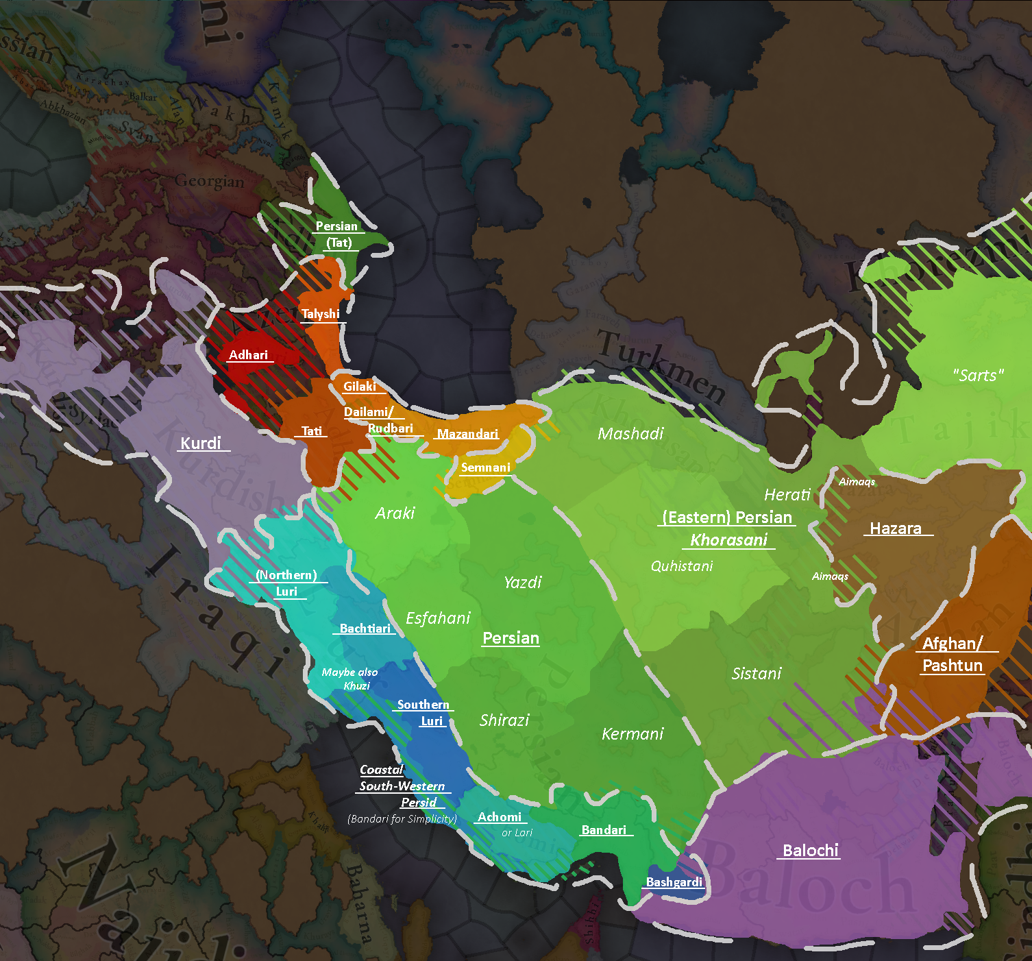
I saw some people mention it already, but I figured a map and some comprehensive feedback regarding Iran might be appreciated:

First of all, I feel like it should be said that a blob of Persian, a blob of Kurdish etc., isn't exactly ideal. Especially with respects to other regions like Germany, it feels quite unnatural to see the linguistic and ethnic groups shown in their neatly classified 20th and 21st century borders; prior to the rise of nationalism, lifestyle and local communities had a lot more importance than just language, and often times languages blurred easily. Many Northern Lurs were bi-lingual or spoke varieties of transitional dialects between Luri and Kurdi, and additionally shared the same lifestyle as the other semi-nomadic and nomadic tribal groups of the highlands. So having two such neatly classified groups already exist in the 14th century is kinda wild to me but for gameplay reasons, it may be a necessary simplification, very well.
However - one can still adjust the spread of these culture to better align with the historical languages and migratory patterns of certain groups. E.g. The lowlands of Khuzistan were never fully iranian of any kind: during the high medieval period, those lands were inhabited by the mysterious "Khuzi" people, who may or may not have been remnants of the Elymais, before becoming thoroughly arabicized and persianized. The Lurs existed primarily in the highlands, some also in the lowlands. But at no point did they inhabit the coast, which was instead, if at all, inhabited by iranians who spoke most likely a South-Western Coastal Persid dialect.

Next up, still tied to the Lurs: the Bachtiari and Southern Lurs are technically also Luri, their dialects are all transitional, with southern Luri transitioning into Achomi/Lari. All of these groups speak Persid varieties, including the Lurs themselves who's language diverged from middle Persian sometime after the islamic conquest. If the Achomi and Northern Luri get representation, then so should the Bachtiari and Southern Lurs? To complete the Pars Dialect cluster, adding Bandari for the Persid coastal cities, as well as Bashgardi in Bashgard, could make for a neat cluster that will slowly get assimilated by Shirazi and Kermani (Modern Persian).

Next up, Adhari: Adhari is a difficult language to pinpoint as it was never a standardized regional language of any kind. People usually wrote in Persian, or city specific dialects. Linguistically, if we really want to classify it, it probably covered a bunch of local dialects, most of which are extinct today with the exception of Talyshi and Tatic (Takestanim Koini etc.). Tabrizi is attested and we have extended literature available of it, and I'd recommend naming this specific regional dialect Adhari. If you guys prefer to keep cultures to a minimum, then at least be accurate and merge Talysh and Adhari into a single Adhari culture. As for Shirvan: The area was never Adhari speaking for as far as we know. The area was settled during the sassanid era by persian soldiers who survived there and dominated the area for culturally centuries, with persian serving as the official language of the Shirvanshahs. A separate Tat culture, or simple making the area persian, would both suffice (Additional note for the spread of Talish: if you break up Adhari and keep Talishi, Talishi should extend into Mugan area of what is today Southern Azerbaijan where the majority of Talysh live).

Next up, Persian proper: Now I get why a single blob of Persian stretching from Isfahan to Samarkand might not be a popular idea as it might make it an extremely strong culture that simultaneously covers a vast geographic areal with different cultures. It makes sense to split it up, but I'd genuinely recommend creating more regional cultures like Sistani, Shirazi, Araki and so forth and have this trend continue all the way over into Central Asia where cities like Bukhara and Samarqand are also majority Persian speaking.
Alternatively one can simply split the culture into east and west, leaving the west "Persian" and while the east becomes "Khorasani". I don't like Tajik as a term as technically, the name was applied to all persians in this time period by the turkic dynasties, but I digress. At the very least adding more regional persian speaking cultures like the Aimaqs, Bandari and so on would be a nice flavour addition in either case.

As for Afghan/ Pashtun: The culture is way too over-represented. Most of what is today Western Afghanistan was historically part of Khorasan, with Herat usually being one of the primary Khorasani cities, hence why it was also the capital of the Timurid Empire. The West of Afghanistan was, and to this day still largely is, overwhelmingly Persian speaking. Only during the collapse of the Safavid Empire and the Afsharid Interregnum, as well as during rise and fall of the Durrani Empire, did Pashtun tribes begin to migrate into western Afghanistan en masse starting in the 18th century, assimilating locals who survived this chaotic time period. The Afghans in northern afghanistan are even more recent arrivals, being largely the result of 19th and 20th century settler policies of the Afghan government.
Since India isn't fully shown yet, it should be noted that Kabul, Peshawar etc. saw Pashtun/Afghan settlment only occur in the 16th century and onward.

Last but not least, what is happening in Central Asia?? Why is Transoxiana Khwarezmian? Even since antiquity, these areas were Sogdian and Bactrian. Khwarazm is the oasis region at the mouth of the Amu Darya, all the way by the Aral Sea. The region was historically inhabited by Iranian Khwarazmians who got largely reduced in number by the mongols and then turkicized during the Mongol Era. They were still Khwarezmian, so having such a culture would not be wrong, though it would have to be made sure that it is Turkic, not Iranian, and it should exist exclusively in Khwarazm. The lands you guys made Khorezmian should be subdivided into regional, Chagatay speaking Turkic cultures, or be renamed to something like Karakhanid, with urban environments being dominated by Persian speakers. Bi-lingualism was a phenomenon however, especially among urban and educated elites. And not all the Turkic groups were necessarily Chagatay/Karluk, as also Kipchak and leftover Oghuz groups continued to partake in a pastoralist lifestyle in this region.
Additionally, having a "Khorasani" Turkic culture feels wrong. Like it is not wrong in the 20th century sense, as the Turkmen in Khorasan are a lot more iranianized than those who live in Turkmenistan, but back then, the differences were between settled and nomadic turkmen if anything. The turkmen in Khorasan are the same turkmen who live around what would later become Ashgabat, at least culturally and linguistically. Their divergence occurred after the russians drew hard lines in the sand during the 19th century. Additionally, the Oghuz migration patterns extend way beyond what you guys are showing. Even back during the Seljuk Era, Oghuz turkmen were migrating deep into Khorasan, that is to say western Afghanistan and eastern Iran, even settling in Fars province in form of the Qashqai, as well as Adharistan, but you guys have that covered with Azeri. But note that nowhere did they make up a necessarily clear majority as the population density, was heavily in favour of the Persian speaking urban settlements they lived around. But demographics are a whole different can of worms.

There is a lot more I can touch upon in a lot more detail but this post is already getting insanely long, so I have a very rough map attached for visualization. Just something to please consider.


Edit: Second Map I made today since I had more time. Included locations in a separate layer below for more accurate spread

cultures 2.0.png


- Note that if Khorasani Turkic gets removed/ merged with Turkmen, and if a unified (Eastern) Persian does not get implemented, Mashadi should be Khorasani instead

- Another Note: Talishi, Adhari and Tati should either be a single "Adhari" culture, or if Talyshi is to be represented separately, then so too should the other (attested) adhari languages/ dialects, with Adhari proper representing Harzandi, Tabrizi etc. (aka, the core of adharistan), Tati representing Takestani, Khoini etc. (potentially also Dailami/ Rudbari/ Galeshi - usually seen as "Gilaki" dialects, but realistically the intermediate between Gilaki and Tatic languages) and lastly Talyshi representing, well, Talysh.

(Also note that I am treating Tatic and Tati as two separate things, because Tatic is the modern linguistic term for the descendant languages of old Azeri/Adhari, whereas Tati is supposed to group together a series of Adhari languages and dialects into a neat southern category to avoid a generalizing Adhari blob from which only Talyshi is singled out for some reason). It would be neat to see every single Adhari dialect represented separately (that is to say, Takestani, Harzandi and so forth), to give some context as to why people starting shifting over to Azeri; - additionally, if Talishi, Adhari and Tati are merged, a unified Adhari culture can probably be grouped with the rest of the Caspian Iranian cultures, but ye.

Another Note regarding the southern Iranian cultures: Bandari, Bashgardi and Achomi are very close to each other, and they can potentially be grouped together separately to keep them unique from the Lurs. Alternatively, they can also be grouped with the other (Western) Persians.


(I am not gonna pretend like I know a lot about the Balochs btw., so someone else with more knowledge can give better feedback there)

((Also this is just to visualize the spread of Iranian cultures; it does not indicate majorities necessarily))

(((I also hope there will be a separate thread for Central Asia because I can make an equally long post about that region as well but don't want to overwhelm the Persia/Caucasus post)))
 
Last edited:
  • 17
  • 10Like
  • 3Love
  • 2
Reactions:
I think a small population of Moghols should exist somewhere in the region. They speak a creole language derived from Mongolian and Dari, and apparently the last speakers were found in some villages around Herat. There is scant written about them. Maybe small populations should be sprinkled about?

 
Last edited:
  • 4Like
  • 4
Reactions:
Kurdish principalities!
Notably even more Kurdish principalities should spring out of this region over time, as a consequence of lack of control and constant conflict. When the Sutayids vacate the premises, their territory winds up either owned by adjacent states or yet more Kurdish principalities, and they aren't sticking around especially long after the start date.
Maps!
Untitled.png

1 is Bitlis, 2 is Hakkari, 3 is Donboli, 4 is Bohtan, 5 is Bahdinan.
Untitled2.png

1 is Ardalan, 2 is Soran. Honestly might not be unreasonable to not have Soran on the map in 1337.

Notably these are just the principalities with any amount of attested evidence in 1337, or even reasonably close. There are probably many more, to say nothing of the ones that popped up as a consequence of being granted autonomy by various ruling empires (Timur, Qara Qoyunlu, Aq Qoyunlu, Safavids, Ottomans).
 
Last edited:
  • 3
  • 2Like
Reactions:
Last but not least, what the fuck is happening in central asia?? Why is Transoxiana Khwarezmian?! Even since antiquity, these areas were sogdian and bactrian. Khwarazm is the oasis region at the mouth of the Amu Darya, all the way by the Aral Sea. The region was historically inhabited by Iranian Khwarazmians who got killed and then turkicized during the Mongol Era. They were still Khwarezmian, so having such a culture would not be wrong, though it would have to be made sure that it is Turkic, not Iranian, and it should exist exclusively in Khwarazm. The lands you guys made Khorezmian should be subdivided into regional, Chagatay speaking turkic cultures, with urban environments being dominated by Persian speakers. Bi-lingualism was a phenomenon however, especially among urban and educated elites. And not all the turkic groups were necessarily chagatay as also kipchak and leftover oghuz groups continued to partake in a pastoralist lifestyle in this region.
Khorezmian is Chagatai-speaking Turkic. As far as we can tell, it was the transitional language between Kara-Khanid and Chagatai languages, spoken roughly between the Mongol Conquest and the establishment and consolidation of Chagatai Khanate.
 
  • 3Like
  • 1
Reactions:
I'll write some of my opinions on this as a native of the area, I'll try to provide some sources as well. I'll preface this by saying that I'm very optimistic about this game and have been surprised by the depth of the research the team has done in each of these maps so far, and the idea of releasing these maps to the community is itself very commendable.

(Note: I've removed my hyperlinks and put the sources in the attached .txt file as it wouldn't let me post otherwise. Words in [ ] indicate a source.)

Political:

Gorgan's snake line towards the Sarygamysh lake is odd. That area is not even a fertile valley, it's desert like the rest. I think it's better left as colonizable land. Others have commented on this better than me.

The dynasty name for Gilan is "Bandar-e Anzali" which is a city, might've been an error. Or if their dynasty is randomly generated, then Bandar-e Anzali should definitely not be a possible dynasty name. The real historical dynasties of that area (that have been consolidated into one Gilan tag) would be Ispahbudan, Nasirwandan (Naservandan), Kiyaiyan (Kar-Kiya), Ishaqwandan (Eshaqvandan), Tajaspids, etc

Geography:

The southern Caspian coast climate seems wrong, it's generally wetter and more temperate. [Rainfall] [Koppen Classification]. As for topography, I would prefer if the Kojur and Chalus locations were formed as north-south provinces where the northern one is a plain and southern one mountain, but since the northern flat strip of land in that area is only 3km wide I understand the simplification.

I'm not sure why the vegetation in Southern Iraq and Khuzestan is "Desert" as that area is one of the most productive in the region. If this is to represent the collapse of irrigation as a consequence of the Mongols then I hope there's a way to restore it or change vegetation coverage. Not entirely sure about Iraq but Khuzestan for example accounts for 11% of Iran's rice and 12% of its wheat production. [This source] in general might come in very handy for that, especially location goods production.

The location of Gorgan should probably not have 26,000 people. It was fully destroyed after the Mongol invasion and that area in general was not repopulated on a serious scale until the 20th century due to the collapse of the Gorgan Wall. [19th Century Journal, Page 616]

Cultural:

I'm not sure about Mongol culture in the Gorgan location either. That area was never settled by Mongols directly, should probably be a mix of Turkmen and Khorasani. Mazandarani culture should also expand east as far as the Gorgan location, replacing Khorasani.

Speaking of which, I don't think Khorasani culture has any special distinctions from the other Persian sub-ethnicities other than having existed in EU4 to be a separate culture. Either split all Persian sub-ethnicities into their own groups (Yazdi, Kermani, Isfahani, etc) or absorb Khorasani into Persian. One argument could be made that Khorasanis are an intermediate between eastern Persians (Tajik) and the western ones but a similar argument could also be made for Hamedanis' relation to Lurs and Kurds and their Fahlavi heritage, etc. Same for every sub-group really.

The modern Tehran region (southern Alborz) is too Persian, while Ray would have been, the rural area to its north (including the town of Tehran) would have hadCaspian (Mazandarani) influences. There are several sources for this one: [1] [2] [3] [4] (easier to find the relevant bits by searching mazandaran, caspian or people / language). There's also an underrepresentation of [Tat people], which I imagine are represented by Adhari. As for that, Adhari should probably extend further east into the southern Alborz region.

Speaking of Adhari, Shirvan probably shouldn't be Adhari. The [modern Iranian speakers] (other than Talysh) of that region speak a language that developed from Persian and most medieval sources signal towards the same. In this case I think it's reasonable to create a new "Shirvani" culture for that purpose, since as far as I know their distinction from the rest of the Persians already started in the late Sassanid period. Generally it should be a mix of Shirvani (more in the east), Turkic (Azeri, more in the west) and the local Caucasian peoples (more in the north).
This really makes it sound like Gilan should be multiple different tags.

Here is a source I found that has some info on that topic:

https://archive.org/details/Rabino19181920Gilan/page/n1/mode/1up
 
Last edited:
  • 2
Reactions:
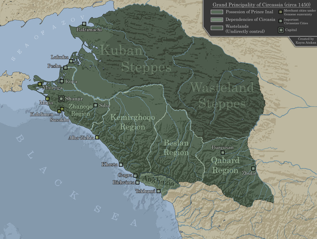
I am unsure if Circassia should exist as a single country at this point of time. It is a bit difficult to say, because Circassians were divided into various small principalities that nevertheless paid homage to a supreme ruler. However, in the 1400s Inal the Great ”unified” Circassia, and representing it as a single country before that might be inaccurate.


However before this, a Circassian kingdom existed in what is considered western Circassia, ruled by Verzacht in the 1330s when the game takes place. He was thanked by the Pope for spreading christianity among Circassians, but it’s unclear how far his rule over them extended. The wikipedia articles are frankly contradictory and not chronological, often speaking of Inal being a unifying figure and the first ”grand prince” and then talking about other rulers/kings/grand princes of Circassia that preceded him. Even the Circassia/Zichia articles sort of overlap, and even mean the same thing as Zichia is simply an altenate form of Circassia. Wikipedia really is not the best source of Circassian history for the period.

(the map in the article is from the 1700s)

There are probably better sources out there, but I haven’t found them. In any case, representing Circassia as a single tag might be fine as long as it is a very decentralized one, with little central government to speak of. Also, should Genoa really control that much land around the Taman peninsula? Some of the locations should probably be owned by Circassia instead, but I am unsure about this too.
 
  • 11Like
  • 1
Reactions:
Maps!
View attachment 1187446
1 is Bitlis, 2 is Hakkari, 3 is Donboli, 4 is Bohtan, 5 is Bahdinan.
View attachment 1187447
1 is Ardalan, 2 is Soran. Honestly might not be unreasonable to not have Soran on the map in 1337.

Notably these are just the principalities with any amount of attested evidence in 1337, or even reasonably close. There are probably many more, to say nothing of the ones that popped up as a consequence of being granted autonomy by various ruling empires (Timur, Qara Qoyunlu, Aq Qoyunlu, Safavids, Ottomans).
I don't think Bitlis principality should owns Ahlat. https://islamansiklopedisi.org.tr/ahlat (this site is the one of the maybe the most largest online islamic-turkish historical encyclopedia there) you can translate it, it basically says at the time Diyarbekr and Ahlat was the one of the central provinces of the Sutayids. And after 1343-1350, local tribes gains control over the areas. This PDF is good too: https://isamveri.org/pdfsbv/D00142/2002_12/2002_12_CEVIKA.pdf . Its subject is Dilmaçids but it mentions neighboring regions too, you search Ahlat and look at the last results. Otherwise I too support creation of Bitlis principality. You can see my text about it here: https://forum.paradoxplaza.com/forum/threads/tinto-maps-7-anatolia-feedback.1702644/post-29872811 (open Previous Suggestions spoiler and then About Dulkadirids, Dilmaçids and Şerefoğulları spoiler)
 
  • 3
Reactions:
I don't think Bitlis principality should owns Ahlat. https://islamansiklopedisi.org.tr/ahlat (this site is the one of the maybe the most largest online islamic-turkish historical encyclopedia there) you can translate it, it basically says at the time Diyarbekr and Ahlat was the one of the central provinces of the Sutayids. And after 1343-1350, local tribes gains control over the areas. This PDF is good too: https://isamveri.org/pdfsbv/D00142/2002_12/2002_12_CEVIKA.pdf . Its subject is Dilmaçids but it mentions neighboring regions too, you search Ahlat and look at the last results. Otherwise I too support creation of Bitlis principality. You can see my text about it here: https://forum.paradoxplaza.com/forum/threads/tinto-maps-7-anatolia-feedback.1702644/post-29872811 (open Previous Suggestions spoiler and then About Dulkadirids, Dilmaçids and Şerefoğulları spoiler)
Makes sense. As an update to that, I'd say that the northern stretch of territory I have in the map that I presented (Hinis, Malazgirt, etc.) should belong to the Hakkari as well, but they slowly recede from the region over time. My source is this, describing the history of the principality that ultimately fills the void that they leave behind.

So then the updated map would be this:
Untitled.png

With some amount of giving Arlat and other territory that I just gave to the Hakkari, to the Sutayids for the Hakkari to acquire once the Sutayids leave.
 
Last edited:
  • 1Like
Reactions: