• We have updated our Community Code of Conduct. Please read through the new rules for the forum that are an integral part of Paradox Interactive’s User Agreement.

Tinto Maps #25 - 8th of November 2024 - South East Asia

Hello, and welcome to another week of fun unveiling of the map of Project Casar. In this week’s Tinto Maps we will be taking a look at South East Asia, so without further ado let’s get started.

Countries
Countries.png
Colored wastelands.png

Quite a variety of countries in the area. The regional power in the decades before 1337 was the Khmer Empire, although at this point they are already in decline and have lost much of their previous hegemony. On the west, the fall of the Burmese Pagan Kingdom and the following Mongol invasions gave rise to the disunited kingdoms of Pinya, Sagaing, Prome, and Toungoo, while in the south the Mon kingdom of Hanthawaddy (also known as Pegu) also split apart. On the center, the decline of the old Lavo Kingdom and its subjugation to the Khmer gave way to the emergence of the Kingdom of Sukhothai when Khmer started its decline too, and Sukhothai is emerging as the dominant Thai kingdom in the area. However, Ayodhya is already gestating the rise of another great kingdom, as King Ramathibodi, the founder of the Ayutthaya Kingdom is already poised to gain power in the region. On the east coast, the Kingdom of Đại Việt is under the orbit of the Yuán, with constant conflict with the southern Hindu kingdom of Champa.

Societies of Pops
SoP.png

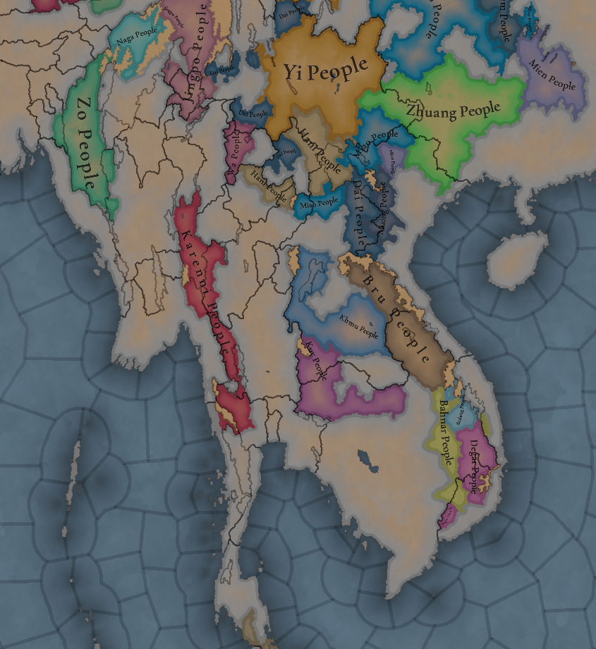
A region very rich in Societies of Pops, which will make it definitely an interesting area.

Dynasties
Dynasties.png

The dynasty of the old Pagan Empire is still alive in Prome, with many other dynasties in the region having ties with it, while the different Thai dynasties also have ties among each other.

Locations
Locations.png

Locations zoom 1.png

Locations zoom 2.png

Locations zoom 3.png

Provinces
Provinces.png

Provinces zoom 1.png

Provinces zoom 2.png

Areas
Areas.png

Unfortunately, currently the name of the sea area encroaches too much into the land (this will be fixed, don’t worry), but the blue area that gets underneath that name is Chao Phraya.

Terrain
Topography.png

Vegetation.png

Climate.png

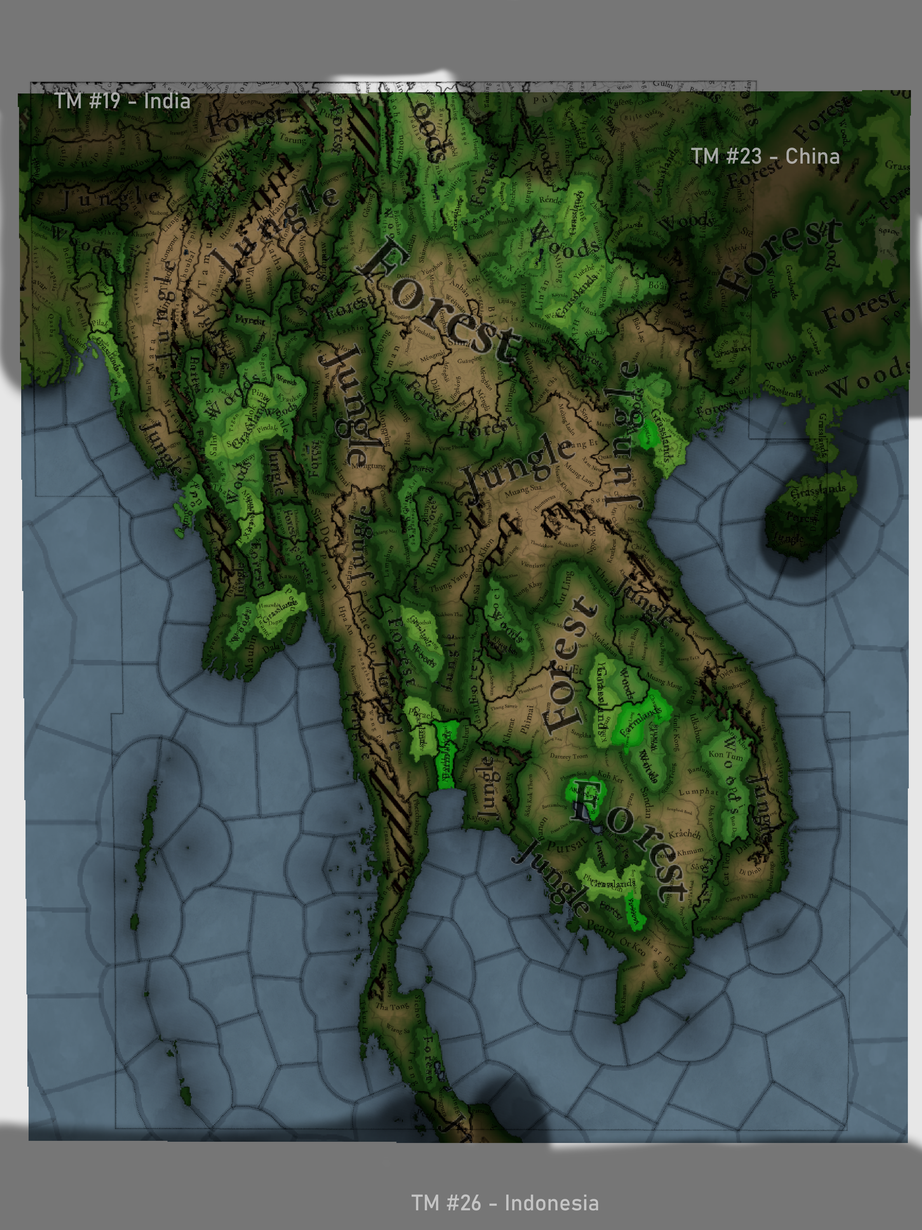
Tropical and jungle almost everywhere, with quite a bit of comparison between the southern flatlands and the northern mountainous areas.

Development
Development.png

Not as developed as the surrounding India or China, but the main centers of power (like Angkor, Pagan, and Sukhothai) are a bit more developed.

Natural Harbors
Natural Harbors.png


Cultures
Cultures.png

A quite variety of cultures, although the southern areas haven’t had their minorities done yet so there will be even more variation there.

Languages
Languages.png

As an addition from this week one, we have a new map to show with the languages. Keep in mind that this area hasn't had any language families or dialects done yet, so there is a bit of grouping.

Religions
Religion.png

Again, keep in mind that minorities are not done, so there will be more variation added inside the Theravada block, as there has to be still quite a bit of Hinduism presence in Khmer (its conversion from Hinduism to Buddhism at that point was one of the causes of its decline), and quite a bit more of Satsana Phi among all the Tai peoples.

Raw Materials
Raw Resources.png

Raw Resources zoom 1.png
Raw Resources zoom 2.png
Raw Resources zoom 3.png
Quite a variation of resources, although dominated mainly by lumber and rice.

Markets
Markets.png

The commerce is dominated by those countries benefiting from sea trade routes, but the emergence of a strong Ayutthaya Kingdom in the middle will for sure cause a change in the balance of powers.

Population
Population.png

Population zoom 1.png
Population zoom 2.png
Population zoom 3.png
Population zoom 4.png
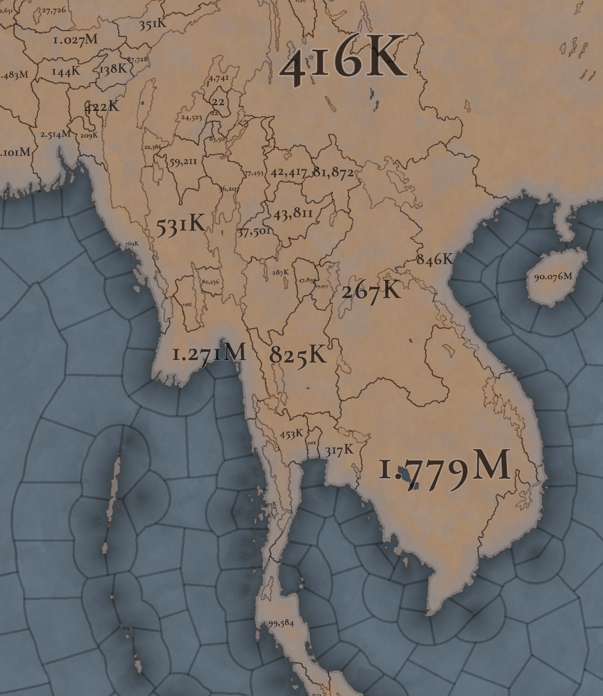
Khmer is still the most populated, but other countries around don’t fall that far behind, especially when they manage to unify their areas a bit. There’s also a couple of locations appearing as 0 population that is definitely a bug that will have to be fixed.

That is all for this week. Join us next week when we set sail to take a look at the maritime part of South East Asia by taking a look at all the archipelago of Indonesia (including the Philippines). Hope to see you there.
 
  • 117Like
  • 39Love
  • 3
  • 1
  • 1
Reactions:
Massive wrong here. There are no Khasic languages in Thailand. Bahnaric and Katuic languages are entirely different from Khmer and no where they are treated as a single language. Khmer is very isolating and monosyllabic while Katuic languages are much more inflectional and polysyllabic-types.

"Bru" is not a religion. The most accurate word to describe the religions that encompass various tribal peoples across the mountainous areas of Mainland Southeast Asia is animism/shamanism. Their traditions, beliefs, rituals actually share more common things with ethnic aboriginal groups in South China, Tibet, Mongolia,... than Oceanic peoples in the Malay Archipelago and the Pacific.
 
  • 4
Reactions:
Is there any chance to make some minor changes to the climate of the heartland of Champa (current day Binh Thuan/Ninh Thuan provinces in Vietnam) - it's really quite an arid place similar to the one in Burma. Their heartland is almost desertlike with sand dunes along the coast and sparse dry vegetation inland. I would even change it to not be producing rice. Maybe the product could change to salt or fish.

You'll notice Isan (the Korat plateau) is also listed as savannah, not jungle.
View attachment 1213912

Correct. The later Cham demographic centers in modern-day Ninh Thuan and Binh Thuan are located in Southern Vietnam lowland dry forest
, with average rainfall less than 800 millimetres. Some areas even receive less than 400 millimetres like Northeast part of Binh Thuan where nothing grows there but just pure sand and rocks. I was been there few years ago. it was basically the opposite of a tropical jungle.
Đồi-cát-Nam-Cương-ivivu-12-@vietnamtravel_vn.jpg
 
Last edited:
  • 6Like
  • 3
  • 2Love
Reactions:
1. If they are relatively close, there should not be two locations with the same name, so some kind of variation of it would be needed, either by modifying the name a bit as you said, or by choosing another name. If they are far apart enough it's not a problem as they won't be confused.
I find identically named provinces very confusing even if they are far apart. Particularly if I own both of them and have an event where they are mentioned in an effect without a "zoom to" button..
 
  • 2Like
Reactions:
I looked at the locations that produce cotton:

Indrapura: Jungle, Tropical
Phayuhakhiri: Jungle, Tropical
Phyu: Forest, Tropical
Phayau: Forest, Tropical

Cotton is very sensitive to rainfall during some phases of its growing cycle, so historically it hasn't been grown in areas that don't have a dry season or have high average annual precipitation.
Maritime South East Asia is especially known for being unsuitable for cotton production and more recently, new varieties of cotton have been cultivated that are better adapted to the climate there.
But even nowadays, especially considering how much textile industry there is in South East Asia, very little cotton is actually grown locally. The only notable cotton producer on this map would be Burma, since it has areas with dry climate.

So I would be very careful about placing cotton in locations with tropical climate, especially in jungle locations.

Locations with tropical rainforest climate shouldn't have cotton at all, this isn't applicable for this region.
Locations with tropical monsoon climate and tropical savannah climate can grow cotton, but depending on the local conditions, it may be difficult or produce low yields.

My suggestion would be to only place cotton in locations with tropical climate if there are sources that show that cotton was grown in these locations (such as some parts of India). Otherwise, you can assume that it wasn't.
 
  • 4Like
  • 2
  • 1
Reactions:
I looked at the locations that produce cotton:

Indrapura: Jungle, Tropical
Phayuhakhiri: Jungle, Tropical
Phyu: Forest, Tropical
Phayau: Forest, Tropical

Cotton is very sensitive to rainfall during some phases of its growing cycle, so historically it hasn't been grown in areas that don't have a dry season or have high average annual precipitation.
Maritime South East Asia is especially known for being unsuitable for cotton production and more recently, new varieties of cotton have been cultivated that are better adapted to the climate there.
But even nowadays, especially considering how much textile industry there is in South East Asia, very little cotton is actually grown locally. The only notable cotton producer on this map would be Burma, since it has areas with dry climate.

So I would be very careful about placing cotton in locations with tropical climate, especially in jungle locations.

Locations with tropical rainforest climate shouldn't have cotton at all, this isn't applicable for this region.
Locations with tropical monsoon climate and tropical savannah climate can grow cotton, but depending on the local conditions, it may be difficult or produce low yields.

My suggestion would be to only place cotton in locations with tropical climate if there are sources that show that cotton was grown in these locations (such as some parts of India). Otherwise, you can assume that it wasn't.

Speaking of cotton, the Irrawaddy valley is one place that should have more (especially in the arid zones), currently there's only one cotton-producing location in the south.

Screenshot_20241109-152344~3.png

Screenshot_20241109-152310~2.png

Gazetteer of Upper Burma and the Shan States, Part I. Vol.II

This was written in the late 19th century, when cotton cultivation was declining, but it was historically more widespread.
 
  • 4
Reactions:
Moving from the other thread:

1. I doubt that Khmer as a language was spoken over an area that expansive. As a Cambodian, I assure you that there were pockets of Pearic and Bahnaric languages. Added context: Pearic and Bahanaric languages aren't dialects of Khmer. We may call them Khmer Loeu but their languages aren't that mutually intellegable.
2. Why is Khasi randomly representing what looks to be the Katu people? Their languages are pretty distantly related, about as distantly related as Khmer is from Vietnamese.
3. Assamese is seperate but unrelated to Tai? I don’t know what else to say, that’s a weird decision, unless Assamese is supposed to represent something else (which could be the case, since Tai is there). I think Assamese needs a rename to prevent confusion. The term "Assam" is of Tai origin and that confused me into believing it could possibly represent a Tai culture.
4. Khmu and Bai also seems to be missing.
5. This one is more nitpicky, I’d love to see an Andamanese culture. So, I think they are isolated enough to be given their own language, they have almost nothing to do with us Austroasiatics. I see a couple of people suggesting they could link with Ainu in Japan, but don't quote me on that.
 
  • 3Like
  • 1
Reactions:
Ultimately inconsequential complaint, but I'd refer to the country as "Cambodia" since it's what it called itself (កម្វុជ, Kambuja), while also being more familiar to modern audiences. "Khmer Empire" is a modern historiographical convention. It's also nice that you guys fixed the name order issue though ("[adjective] Empire" rather than "Empire of [country]").
While on the topic of tags: In EU4 I always thought it was weird that Taungoo was just Taungoo, even in the Konbaung period. Any Burmese history experts can tell me if it would make sense for there to be separate tags? Perhaps there should be a single "Burma" tag? Will there also be an event for Đại Việt becoming Việt Nam, as just a comestic thing rather than as a tag switch?
As a Cambodian, it's called the Angkorian Empire to distinguish it from what happened post-1431. From 1431 onwards (ignoring the stuff that happened in the cold war) the polity is called Cambodia. I personally don't like the name Khmer Empire because it's not distinctive enough. It's like calling Byzantium the Greek Empire.
 
  • 3Like
  • 3
Reactions:
Red Yuan is an artificial colour selection made by EU4, which is presumably why you feel like it's the best (along with the brownish Ming colour), but there isn't a real historical basis for that. Of course, colours can be completely arbitrary and for many nations they necessarily will be, but since Yuan and Ming are such pivotal states during the game's time period, I'd like to see something more historical for them instead of just clinging to what was the case in previous games.

As regards the colours I would prefer, Ming is in my eyes a shoe-in for red. Red is the colour associated with the Han Chinese and the Ming emperors' surname, 朱 (zhū), means cinnabar, which was historically used to make a very nice deep red pigment. For Yuan, white (the colour chosen by them as their imperial colour, associated with the element metal) or some sort of blue (the colour of the Mongol people) are both fine options. I personally favour white.
if we are gonna use historical data, what makes ottomans green instead of red? Yes they used green often but they used red alot more.

if we need historical data for this then this needs to apply to every single country.
 
  • 3
  • 1
Reactions:
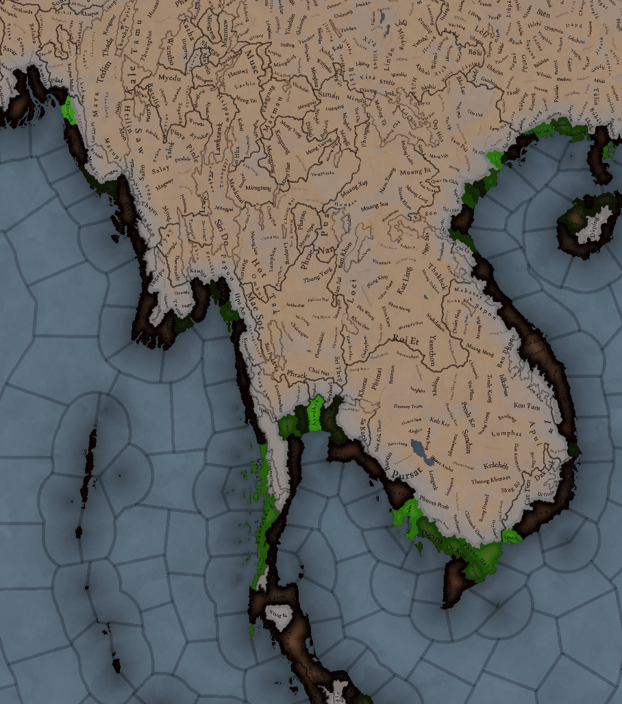
There should be more natural harbors in:
- Coastal regions of Arakan, Myanmar
- Rangoon, Myanmar
- Sattahip, Thailand
- Almost all coastal provinces located in Champa. Just look at the map, the place is full of natural harbors.
1731171136320.png

- modern day Hue, Hoi An, Da Nang, Quang Ninh, Vietnam
 
Last edited:
  • 2Like
  • 1
  • 1
Reactions:
There should be more natural harbors in:
- Coastal regions of Arakan, Myanmar
- Rangoon, Myanmar
- Sattahip, Thailand
- Almost all coatsal provinces located in south Champa. Just look at the map, the place is full of natural harbors
- modern day Hue, Hoi An, Da Nang, Quang Ning, Vietnam
How did the monsoon affect these harbors?
I know that on the eastern coast of the Malayan Peninsula, the harbors were closed for several months during monsoon season (musim kuala tutup) so that would naturally affect the rating of these natural harbors. The western coast was shielded by Sumatra.
Does a season like that not exist in Champa, for example?
 
I prepared a big post for Malaya but since it's (correctly) categorized with Maritime South East Asia, it'll have to wait another week. :p

One thing I'm going to propose for Malaya is to represent that people lived on the coast and along rivers, with large tracts of rainforests unexplored until the 1880s, so it should look more like the Amazon or Siberia than modern Malaya.
To illustrate, here are the location maps for my two proposals, one with 42 locations and one with 31 locations.
These are the historical routes to cross the peninsula:
View attachment 1213636
(Source is Wheatley, The Golden Khersonese: Studies in the Historical Geography of the Malay Peninsula before A.D. 1500)

So naturally I'm going to propose adding more impassable land to the northern peninsula as well.
For example like this:
View attachment 1213638
Oh and by the way, the Perlis locations seems to extend too far north? It shouldn't even be called Perlis in this time period, but that's for next week I guess.
They may be rainforests but those aren't passable and can be generally easily made passable unlike mountain ranges, i don't think its a good idea to treat rainforests as impassable like sky high mountain ranges, the Titiwangsa mountain range is probably enough already
 
They may be rainforests but those aren't passable and can be generally easily made passable unlike mountain ranges, i don't think its a good idea to treat rainforests as impassable like sky high mountain ranges, the Titiwangsa mountain range is probably enough already
How can they be easily made passable in this time period? They weren't even really explored until the late 19th century.
Do you have any examples of armies moving through these areas instead of sticking to the river routes?
All examples of military campaigns in Malaya that I've seen either mention the river routes or used ships.
 
  • 1Like
Reactions:
Not sure if it's been mentioned yet, but the liturgical language of Dai Viet should be Chinese, as Classical Chinese was the language of scholarship and religion in Vietnam all the way until the 20th century.
 
  • 5Like
Reactions:
It's been a while, but here's another Topgraphical analysis (at some point I'll do the rest of Asia, but there's a bazillion Locations there that's scaring me off!)

In summary:
- In general a pretty good topographical Tinto maps
- Needs more hills on a lot of the transition areas, while breaking up the Yungui and Shan massifs a bit more
- Several Locations need switching between mountains-hills, plateas-hills, and at some places even flatlands-mountains
- Wetland areas need to be expanded a little bit.
- Wetlands of North Vietnam were overlooked.
- Impassables: very subjective in this tinto maps, I refrained from adding any major suggestions.

Current Topography design by TintoSuggested Topography changes overview (as usual with suggested topographic crossings)Suggested Topography changes changelog (as usual with suggested topographic crossings)
Topo_Tinto.png
Topo_Suggested.png
Topo_Suggested_Changelog.png

Terrain Ruggedness IndexDEM colorised with exaggeration of lower topography
TRI.png
Topo_DEM_Colorful.png

Wetlands (with suggested ingame extents) on Global wetlands and lakes databaseGlobal flood risk map (100 year event extents)
Wetlands_v2.png
30N56Kj.png
 
Last edited:
  • 11Like
  • 7
  • 3Love
Reactions:
Apart from topography I wanted to try and evaluate two other factors:
- food crop placement
- vegetation

Food crop placement
I tried to evaluate whether the food goods distribution makes sense according to the innate soil fertility.
I discovered there's plenty of potential to rearrange goods like wheat and rice.

Soil fertility depends on a lot of factors, among which cation exchange capacity (='accessible minerals'), potential rooting depth, soil grain size,...
Tropical regions are notoriously tricky for growing crops, as the rainy regions experience a lot of nutrient leeching.

Southeast Asia is no different in this regard.

The FAO has plenty of resources available on the topic, and I recolored their maps for a more intuitive use for our purposes.

Soil Fertility classes, recolored in broad categoriesExtent of Marginal and Very Marginal soil fertility (red line) and the food crop distribution within.Second version where Wheat and Rice are colored bright yellow within the 'infertile zone'Modern population distribution mask, with pitch black having 0 people / km²
Soil_Fertility.png
Soil_Fertility_NoWheatEtc.png
Soil_Fertility_NoWheatEtc_v2.png
Population_ZeroPopulation.png


Vegetation patterns.

Extrapolating vegetation patterns from modern times back to historical periods is nigh impossible to perform correctly. Nonetheless, often woodlands have been stripped and repurposed for plantations. These plants also photosynthesize, which are also measurable from sattelites. Therefore, the NDVI (Normalized difference vegetation index) is a great tool to visualise relative vegetation density, where plantations are also still recognisable. Of course, forests that were stripped for herbaceous crops will of course appear as grasslands, relatively speaking.

Luckily, the HYDE (History database of the Global environment) also has some indicative models and maps on this subject.

I therefore think that perhaps Khmer-Ayutthaya could use a bit more 'woods' here and there, while central Myanmar is dryer with more grasslands and less dense woodland than currently portayed.

Tinto's vegetation patternSattelite NDVI imagery recolored for vegetation intensity (dark green)"Anthromes" 1300 AD (Hyde 3.3 database)
Brighter = less people = intact wilderness
Population density 1300 AD (Hyde 3.3 database)
Vegetation_Tinto.png
Vegetation_NDVI.png
Anthromes1300.png
Population_HYDE-density.png
 

Attachments

  • Population_HYDE-density.png
    Population_HYDE-density.png
    5,2 MB · Views: 0
  • 10Like
  • 8
  • 2Love
Reactions:
It can be a bit difficult to read some of the resource names when the RGO is a dark color on the map. Could the names have a white outline much like the trademarket names? Also will there be an option to have RGO's represented by icons instead of words?
 
  • 2Like
Reactions: