• We have updated our Community Code of Conduct. Please read through the new rules for the forum that are an integral part of Paradox Interactive’s User Agreement.

Tinto Maps #25 - 8th of November 2024 - South East Asia

Hello, and welcome to another week of fun unveiling of the map of Project Casar. In this week’s Tinto Maps we will be taking a look at South East Asia, so without further ado let’s get started.

Countries
Countries.png
Colored wastelands.png

Quite a variety of countries in the area. The regional power in the decades before 1337 was the Khmer Empire, although at this point they are already in decline and have lost much of their previous hegemony. On the west, the fall of the Burmese Pagan Kingdom and the following Mongol invasions gave rise to the disunited kingdoms of Pinya, Sagaing, Prome, and Toungoo, while in the south the Mon kingdom of Hanthawaddy (also known as Pegu) also split apart. On the center, the decline of the old Lavo Kingdom and its subjugation to the Khmer gave way to the emergence of the Kingdom of Sukhothai when Khmer started its decline too, and Sukhothai is emerging as the dominant Thai kingdom in the area. However, Ayodhya is already gestating the rise of another great kingdom, as King Ramathibodi, the founder of the Ayutthaya Kingdom is already poised to gain power in the region. On the east coast, the Kingdom of Đại Việt is under the orbit of the Yuán, with constant conflict with the southern Hindu kingdom of Champa.

Societies of Pops
SoP.png

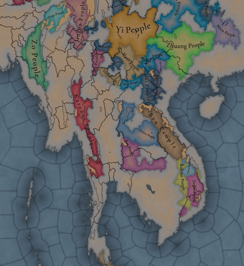
A region very rich in Societies of Pops, which will make it definitely an interesting area.

Dynasties
Dynasties.png

The dynasty of the old Pagan Empire is still alive in Prome, with many other dynasties in the region having ties with it, while the different Thai dynasties also have ties among each other.

Locations
Locations.png

Locations zoom 1.png

Locations zoom 2.png

Locations zoom 3.png

Provinces
Provinces.png

Provinces zoom 1.png

Provinces zoom 2.png

Areas
Areas.png

Unfortunately, currently the name of the sea area encroaches too much into the land (this will be fixed, don’t worry), but the blue area that gets underneath that name is Chao Phraya.

Terrain
Topography.png

Vegetation.png

Climate.png

Tropical and jungle almost everywhere, with quite a bit of comparison between the southern flatlands and the northern mountainous areas.

Development
Development.png

Not as developed as the surrounding India or China, but the main centers of power (like Angkor, Pagan, and Sukhothai) are a bit more developed.

Natural Harbors
Natural Harbors.png


Cultures
Cultures.png

A quite variety of cultures, although the southern areas haven’t had their minorities done yet so there will be even more variation there.

Languages
Languages.png

As an addition from this week one, we have a new map to show with the languages. Keep in mind that this area hasn't had any language families or dialects done yet, so there is a bit of grouping.

Religions
Religion.png

Again, keep in mind that minorities are not done, so there will be more variation added inside the Theravada block, as there has to be still quite a bit of Hinduism presence in Khmer (its conversion from Hinduism to Buddhism at that point was one of the causes of its decline), and quite a bit more of Satsana Phi among all the Tai peoples.

Raw Materials
Raw Resources.png

Raw Resources zoom 1.png
Raw Resources zoom 2.png
Raw Resources zoom 3.png
Quite a variation of resources, although dominated mainly by lumber and rice.

Markets
Markets.png

The commerce is dominated by those countries benefiting from sea trade routes, but the emergence of a strong Ayutthaya Kingdom in the middle will for sure cause a change in the balance of powers.

Population
Population.png

Population zoom 1.png
Population zoom 2.png
Population zoom 3.png
Population zoom 4.png
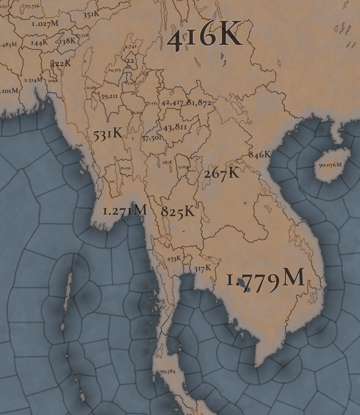
Khmer is still the most populated, but other countries around don’t fall that far behind, especially when they manage to unify their areas a bit. There’s also a couple of locations appearing as 0 population that is definitely a bug that will have to be fixed.

That is all for this week. Join us next week when we set sail to take a look at the maritime part of South East Asia by taking a look at all the archipelago of Indonesia (including the Philippines). Hope to see you there.
 
  • 117Like
  • 39Love
  • 3
  • 1
  • 1
Reactions:
As a Cambodian, it's called the Angkorian Empire to distinguish it from what happened post-1431. From 1431 onwards (ignoring the stuff that happened in the cold war) the polity is called Cambodia. I personally don't like the name Khmer Empire because it's not distinctive enough. It's like calling Byzantium the Greek Empire.
"Angkorian Empire" is a similarly historiographical convention. The country called itself "Cambodia" throughout all of those periods.
 
  • 4Like
Reactions:
Red River Delta is one of the most fertile land in Asia and have the representation of agriculture civilization early in history (at least from 7th BC) and get high boost of technic after Chinese colonize it in 207 BCE. It also many special goods,a good location for trading between China & other nation in the south, high mountain protect it from conflicts from China & invasion of other forces make it became a good place to migrate in the past.
According to Han Shu, the Han Dynasty census year 2AC, the Red River Delta (交趾郡) population already reach 746,237 people. And this is only census of Red River Delta, if inculded census of north-central Vietnam are, the number would be higher
jizo.jpg

By that, the number 846k in 1337 is absurd

Bonus Han Dynasty census year 2AC table: 郡国= County, 人数 = population, 户数 = number of family ( in the past, asian live together from generation to generation so each family will have from 5-20 people)
aa.jpg
 
  • 7Like
  • 4
Reactions:
Not sure if it's been mentioned yet, but the liturgical language of Dai Viet should be Chinese, as Classical Chinese was the language of scholarship and religion in Vietnam all the way until the 20th century.
I think there’s a misunderstanding here:

Chinese characters did indeed have a deep influence throughout the second millennium in Vietnam (after gaining independence). However, it was just the Chinese characters themselves, as during this period, the Vietnamese gradually created their own script called "Chữ Nôm."

Chinese characters were used among scholars and in the royal court, primarily for recording history and poetry, not for communication or discussing state affairs. For the Vietnamese, we call it "Hán Việt," similar to how the Japanese call it "Kanji" or the Koreans call it "Hanja" — reading Chinese characters in the local language.

The Vietnamese did not use Classical Chinese in daily communication; they still spoke Old-Middle Vietnamese.

P.S.:
If Project Caesar had a map mode for court languages, it would likely be challenging to distinguish between the concepts of language and script, as Vietnamese dynasties used Chinese characters but spoke Vietnamese.
 
Last edited:
  • 5Like
  • 2
  • 1
Reactions:
Terrain should have a big role for Dai Viet gameplay, Mountains in the north & west Vietnam make any force outside want to invade Dai Viet not only need to have a big army to deal with 3-5m people in Red River Delta but also have to prepare good supply chain to make sure they can surpass those mountain. mountains beside protec Dai Viet also become a problem for Daiviet to expanding to the west and make it can't become a big empire like Siam or Toungoo.
So only possible way is the south with lower mountains. Dai Viet then will need to pay high cost and time to assimilate the Champ & land reclamation in the Mekong Delta. This will create time to other power in region like Thai or Burma united to rivalry with Dai Viet later

Vietnam_Topography.png
 
Last edited:
  • 3Like
  • 1
Reactions:
Correct. The later Cham demographic centers in modern-day Ninh Thuan and Binh Thuan are located in Southern Vietnam lowland dry forest
, with average rainfall less than 800 millimetres. Some areas even receive less than 400 millimetres like Northeast part of Binh Thuan where nothing grows there but just pure sand and rocks. I was been there few years ago. it was basically the opposite of a tropical jungle.
View attachment 1213985
The areas of Ninh Thuan and Binh Thuan in Vietnam look more like Southern California
View attachment 1213978
View attachment 1213980
View attachment 1213981View attachment 1213982View attachment 1213983
I think it needs to expressed in vegetation patterns more than as a change in climate. The area is consistently classified as having a Tropical Savannah climate, which have pronounced dry seasons.

The sand dunes in the picture are but a small part of the entire location, and coastal sand dunes are more related to sedimentary environments than climate patterns. That said, it is indeed clearly not a jungle when looking at the NDVI map of the region, where dense vegetation is more restricted to the uplands. A mix of forest and woods seems more appropriate I think?

1000011675.jpg
1000011673.jpg
1000011678.png

1731230547734.png
1731230569532.png


Locations with tropical rainforest climate shouldn't have cotton at all, this isn't applicable for this region.
Locations with tropical monsoon climate and tropical savannah climate can grow cotton, but depending on the local conditions, it may be difficult or produce low yields.
Considering this region has Savannah climate IRL, doesn't this already fix your concern? 'Tropical jungle' is agreed a no go for those locations then though.
 
  • 4Like
  • 4
Reactions:
Considering this region has Savannah climate IRL, doesn't this already fix your concern? 'Tropical jungle' is agreed a no go for those locations then though.
Possibly, but as far as I can tell, most tropical savannah regions don't really produce much cotton and this region definitely has areas with high rainfall that can be a problem, so it depends on the local conditions.
 
  • 1Like
Reactions:
I prepared a big post for Malaya but since it's (correctly) categorized with Maritime South East Asia, it'll have to wait another week. :p

One thing I'm going to propose for Malaya is to represent that people lived on the coast and along rivers, with large tracts of rainforests unexplored until the 1880s, so it should look more like the Amazon or Siberia than modern Malaya.
To illustrate, here are the location maps for my two proposals, one with 42 locations and one with 31 locations.
These are the historical routes to cross the peninsula:
View attachment 1213636
(Source is Wheatley, The Golden Khersonese: Studies in the Historical Geography of the Malay Peninsula before A.D. 1500)

So naturally I'm going to propose adding more impassable land to the northern peninsula as well.
For example like this:
View attachment 1213638
Oh and by the way, the Perlis locations seems to extend too far north? It shouldn't even be called Perlis in this time period, but that's for next week I guess.
You're correct on perlis already as modern day Satun province was part of Perlis before until Siam and British demarcate borders between Siam and British Malaya in 1897.
 
You're correct on perlis already as modern day Satun province was part of Perlis before until Siam and British demarcate borders between Siam and British Malaya in 1897.
Interesting, so this map is wrong then.

Edit: Wikipedia says
"In 1897 Satun became part of Monthon Syburi (now Kedah), which in 1909 was divided between British Empire and Siam as part of Anglo-Siamese Treaty of 1909. While most of Kedah was ceded to Britain, Satun was awarded to Siam because it had a relatively large Thai population."

So if it became part of Saiburi/Kedah in 1897, that means it wasn't before that?

Edit 2: Ah, so Kedah was divided in 1833 and then re-united in 1897. I think it makes sense to make Satun its own location, due to its Thai population.
 
Last edited:
Interesting, so this map is wrong then.
it was a little more complicated by Siam suppression tactic which they always create more district or cities to make local ruler less power as to prevent them to rebel which they always do all time when opportunity arise.
I would say perlis was part of Queda/ Kedah (Malay name) or Sai Buri (Thai name) before , the closet reference I use was 12 cities of Tanmaling kingdom which was the kingdom that exist around 3th centuries till 13th (It was really old kingdom that share same era with Sukhothai) centuries and Pelis never exist as cities.
the certain picture was Seal of Nakhon Si Thammarat province that show as the pagoda in their province with 12 Chinese years zodiac sign that show cities under Tanmaling kingdom in 1297 and Pelis never was cities shown up according to the record.

Edit 2 i think satun get more siam people because siam people from northern Malay area may contribute on that too but Kedah divide and united mostly from King Siam distrust to sultan of Kedah and British at most as sultan of Kedah may use British who lease Penang Island at that time to secede from Siam and become British protectorate instead and At first British OK with that because they want siam support for war with burma but in the end Siam abandon those vessal to british for loan and revoke extraterritoriality for british and people under british .
 
Last edited:
Fun fact: "Ayodhyā" in sanskrit means "invincible" or "unconquerable". Burmese call them "Yodhyā" which then translates into "vincible" or "conquerable".
The rival boys being boys. So I think if u are playing as a random burmese nation, u should be able to see "Ayodhyā" as "Yodhyā". Just saying.
 
Last edited:
  • 7Haha
Reactions:
Interesting, so this map is wrong then.

Edit: Wikipedia says
"In 1897 Satun became part of Monthon Syburi (now Kedah), which in 1909 was divided between British Empire and Siam as part of Anglo-Siamese Treaty of 1909. While most of Kedah was ceded to Britain, Satun was awarded to Siam because it had a relatively large Thai population."

So if it became part of Saiburi/Kedah in 1897, that means it wasn't before that?

Edit 2: Ah, so Kedah was divided in 1833 and then re-united in 1897. I think it makes sense to make Satun its own location, due to its Thai population.
This is reference from this website https://www.silpa-mag.com/history/article_29737 which is some sort of siam perspective about Anglo-Siamese Treaty of 1909 below this was translate via google translate about what is Siam purpose to sign this secret treaty one day before ratify the treaty that inform to minister meeting.

The territory of the Kingdom of Siam has two levels: the inner provinces and the vassal states… This time, the part that is truly ours, namely Pattani Province, we will administer it like any other province. The part that cannot be administered, as we have already cut off, will gradually become further and further away from us…

At this time, we still have valuable things, so we should use this value to exchange for something else… And the value of the Malay states will continue to fall, so we think it would be a waste of time to exchange…losing the territory this time is a great loss of honor, and it is quite sad, but if we keep it, we will only cause anxiety…

In order to be able to administer the part that is ours, we will have more power when we have a city that does not have power attached to it, because when we have it, we have to govern it with absolute authority, for example, when there is a major bandit, we have to send warships to suppress it, etc. It would be a waste.

For this reason, we have agreed to make an exchange agreement…We have no intention to have the Malay states as an outer territory next to the Westerners. Furthermore, these cities, which appear to be in Thai territory, will fall. But the British came to support us and did not lose anything. It was just a loss of money and gold, not worth much, but it was still felt like a loss of honor.

As for the territory divided this time, we cut off a bit of Kelantan's territory, a bit of Saiburi territory to Pattani Province. But Satun, which was a part of Saiburi, was cut off and came under Phuket canton. From now on, we will not have any more vassal states. We can completely abolish them once and for all.


This may explain a bit why satun exist and which part they were from.
 
Last edited:
Of course, but I just do not agree with calling that polity Cambodia in English. Again, it's still not that distinctive.
I've been campaigning for PC to use non-historiographical terms whenever feasible (if you've seen me in other threads you know how I feel, for instance, about the term "Aztec Empire"). In this case using terms like "Khmer/Angkorian Empire" obfuscates the connections between the historical country and the modern country so I think they shouldn't go with it.
 
  • 2Like
  • 1
Reactions:
I'm not sure if religion in Vietnam is correct here, Buddhism, Confucianism and Daoism were competing there sure, but in the end were they really more common than the local polytheistic set of believes? Shouldn't it be more mixed like in the entire region?

Also what about Religious Syncretism, how is it represented in this game? After all it was huge in most of Asia.
 
Ultimately inconsequential complaint, but I'd refer to the country as "Cambodia" since it's what it called itself (កម្វុជ, Kambuja), while also being more familiar to modern audiences. "Khmer Empire" is a modern historiographical convention. It's also nice that you guys fixed the name order issue though ("[adjective] Empire" rather than "Empire of [country]").
While on the topic of tags: In EU4 I always thought it was weird that Taungoo was just Taungoo, even in the Konbaung period. Any Burmese history experts can tell me if it would make sense for there to be separate tags? Perhaps there should be a single "Burma" tag? Will there also be an event for Đại Việt becoming Việt Nam, as just a comestic thing rather than as a tag switch?
It little complicated thing as cambodia never exist until cambodia become protectanate under france in thai exist after Ayutthaya kingdom attack khmer empire capital but knom aka khmer empire still have some relative side from phimai aka Mahidharapura Daynasty unlike khmer kingdom that their royalty come from in area of modernday cambodia.

Don't expect simplicity much from SEA because this era thing always complicated because some evidence was destroy from possible religious war between Buddhism and Hindu.