• We have updated our Community Code of Conduct. Please read through the new rules for the forum that are an integral part of Paradox Interactive’s User Agreement.

Tinto Maps Special Edition - 6th of January 2025 - The World

Hello, and welcome to a Special Edition of our Tinto Maps series! Today, as a Three Wise Men present (a quite important tradition here in Spain), we'll be taking a look at how the different map modes look like throughout the entire world. Without further ado, maps!

Countries:
Countries1.png

Countries2.png


Building-based Countries:
Building-based.png


SoPs:
SoPs.png


Dynasties:
Dynasties.png


Country Governments:
Governments.png


Court Languages:
Language Court.png


Locations:
Locations.png


Provinces:
Provinces.png


Areas:
Areas.png


Terrain:
Climate.png

Topography.png

Vegetation.png

Johan will talk this Wednesday about the effects of each terrain type.

Development:
Development.png


Harbors:
Harbors.png

European Harbors.png

We're also showing the map of European harbors, as that was not shown previously. Feel free to give your feedback!

Cultures:
Cultures.png


Languages:
Language Dominant.png


Religions:
Religions.png

The Animism split was completed, and the grouping into bigger families is almost finished (there's some pending work on Western and Eastern Africa, but that's it).

Raw Materials:
Raw Materials.png


Markets:
Markets.png


Population:
There is a total of 421M pops worldwide, distributed this way (and pending review, as we have identified some duplicates and errors that we have yet to fix, as in Germany, plus some additions in other places, as discussed in the different Tinto Maps threads):
  • 99.203M in Europe
  • 262.270M in Asia
  • 37.204M in Africa
  • 20.499M in America
  • 1.885M in Oceania
And that's it for today! Although there's pending work yet to be done in the new year, we think that the progress since we started the Tinto Maps series last spring is noticeable, something that we wouldn't have achieved without your feedback. We will keep gathering, processing, and implementing it in the Tinto Maps Feedback posts, continuing with the Maghreb review, which will be shown tomorrow.

And this Friday 10th we will start a new series, Tinto Flavour, in which I will show and talk about the content that we have been creating for Project Caesar. We hope that you will enjoy this new series and that you can keep helping us make this a fun and engaging game. Cheers!

PS: Today is a bank holiday in Spain, so I will reply to the comments tomorrow.
 

Attachments

  • Language Liturgical.png
    Language Liturgical.png
    3,8 MB · Views: 0
  • Raw Materials.png
    Raw Materials.png
    4,1 MB · Views: 0
  • Language Common.png
    Language Common.png
    3,9 MB · Views: 0
  • Language Common.png
    Language Common.png
    3,9 MB · Views: 0
  • 170Love
  • 76Like
  • 7
  • 3
  • 1
Reactions:
but it is the entirety of inner Mongolia that is high dev
No? Only the area around modern Chifeng, Ulanqab, Hohhot, and Baotou are high dev, which borders Hebei and Shanxi. The rest are quite low dev like the rest of the steppes.
There is no reason for the inner mongolai to be that high dev, outperforming major agricultural and urban centres. If it was certain areas in inner Mongolai: Sure, but it is the entirety of inner Mongolia that is high dev. The area around Hulun Buir is barely populated. There is no major agriculture going on either, given its climate.
Hulunbuir looks like this:
It has the same colors as Kuban and the Kazakh Steppes.
 

Attachments

  • Hulunbuir.png
    Hulunbuir.png
    4,4 KB · Views: 0
  • 2Like
  • 1
Reactions:
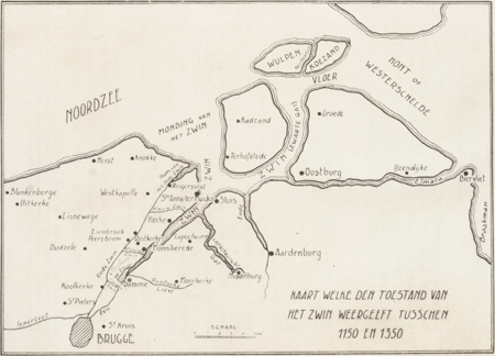
It seems Brugge is still not recognised as a natural harbor, while it was absolutely top notch at the start of the game. The Zwin still went a long way inland back then, while Brugge was far enough from the sea to avoid the big storms.

_vla001193801ill0001.gif
This may be correct but the silting proces that made the Zwin unusable from 1500 onwards had already started at the start of the game. So from 1500 onwards that makes Brugge not a (great) natural harbor for most of the game. Since the map itself is also static it is fair to represent Brugge as a non natural harbor instead of it just dissapearing at some random point in the future
 
  • 3Like
Reactions:
Have you folks considered representing the Birkarls as a building based country? It seems to me they would probably work well for it, somewhat paralleling the Hansa - though I assume the fact that they are not present in any organised countries may cause problems?
I'd be really interested to see if it would be possible to make it work though, since the birkarls are certainly around at this point in history and with significant impact on the history of Meänmaa and Sápmi.

Here's a nice article which summarises a bit about them + links to a more thorough academic paper: https://kulturmiljonorrbotten.com/2016/09/30/nya-forskningsron-om-birkarlarna/
 
  • 1
Reactions:
Is it just me or does northern Finland and Finnmark have an oddly low density of provinces compared to Swedish Norrbotten? Not disastriously so but looks like there's definitely room for a few more provinces up there?
 
This may be correct but the silting proces that made the Zwin unusable from 1500 onwards had already started at the start of the game. So from 1500 onwards that makes Brugge not a (great) natural harbor for most of the game. Since the map itself is also static it is fair to represent Brugge as a non natural harbor instead of it just dissapearing at some random point in the future
Actually, it wasn't so much the power of Mother Nature, as it was the incompetence of the people of Flanders. By building dikes to protect the agricultural lands in the early 1400's, they messed up the power of the tides causing sandbars all over the Zwin. Then they threw a lot of money at it and tried closing a gap near Cadzand, but it actually made things worse. It wasn't until 1566 that a canal was finished to fix these problems, but by then it was way too late. Traders had already moved to Antwerp and worse, the 80 Years war was about to kick off.

It may be too much for the base game, but I'm hoping a future Low Lands DLC will give the player some alt history choices to save the trade in Bruges.

Regarding the map, has it been confirmed it's 100% static? No events/decisions/missions/whatever it's going to be called that will increase or decrease the level? Either way, at the 1337 start date, it should be an A+ harbor location.
 
  • 2Like
Reactions:
Florentine Tuscan being the established literary lingua franca in Italy by the 15th century, so most of the game's time period.

I agree with splitting German+Dutch+Frisian in 2, High+Middle German and Low Saxon+Low Franconian+Frisian zones. Italian could be split into Central Italian and Southern Italian, but this split is fine too

I find the semantical argument frankly irrelevant and boring, I don't care to name things weirdly or in a roundabout way just to make a point to people that shouldn't get all their historical and language history information from a game to begin with.
Yeah that's fine that its the literary lingua franca but but in my eyes the map is about the languages that the common people speak and I'm not sure if Tuscan was the common language for the peasants in the "Italian" region. But I might be wrong with interpreting it that way. And again I don't know a lot about the Italian situation.

Yeah I agree with that, it would show the linguistic diversity a lot better in my opinion.

I agree, if I knew that people would not use the game as historical information I would not care as much either. But the fact is that a decent amount of casual players that will play the game do get basic historical information from the game. And as someone who is effected by peoples opinion about these languages I am pretty passionate about it and don't really see it as irrelevant. The game can do harm to the works of activists that are fighting for these languages survival. As if people keep seeing it as "German" it will continue to do damage. And if wanted the game can actually do really good things by bringing these smaller endangered languages to light and not incorrectly recognizing them as "German".

But all this is assuming that the game will be more mainstream. If it's not and people don't rely on the game for historical information it would not matter nearly as much!
 
Last edited:
  • 2
Reactions:
Isn't the extent of German language and culture exaggerated? I'm quite sure Polabian should be the common language of the entire Pomerania in 1337.
There were some good sources in the EU4 Pomerania thread :)
 
  • 2Like
Reactions:
If I have seen it right, in the Netherlands the eastern location is seen as a natural harbor (which I have no idea about what place it is referencing) while Rotterdam which lays on the natural end of the Rotte connected to the Meuse which in my eyes is a perfect example of a natural harbor. This can be seen in maps of that time.
Rotterdam_Reconstructiekaart_Anno_1340.jpg
 
Last edited:
  • 1Like
Reactions:
Is there a reason why rivers affecting market proximity hasn't been added yet, even though it's been months since the devs showed it?
 
  • 5Like
Reactions:
Thank you very much for the entire world map, it is greatly appreciated and beautiful to look at!

I have a handful of questions:


1. If possible, could we have a map of the global cities and towns if they're ready?

2. Would be possible to see the Diplomatic map mode that we saw for the Maghreb or is that still being worked on? I imagine it would help with feedback on any alliances or wars that should be at the start date.

3. Do Army-Based Countries have their own map mode or have they already been joined to the "main" map mode like we're hoping will eventually occur with SOPs and Building-Based Countries? I don't recall seeing any so I wanted to find out.

4. Are there any other map modes that are planned for Project Caesar eventually (if they can be shared at this time of course) or is this most likely the foreseeable number we'll have? I recall seeing the Black Death on the map in the Situations Tinto Talks but I'm not sure if that map mode was specifically for diseases, situations, etc.

5. Why isn't the exact location for Cahokia given the highest development for that area? It looks like its western locations have more development than Cahokia itself.

6. Would it be possible to have a very high resolution image of the world map(s)? Obviously no pressure since it isn't necessary but I was wondering if it can be done.

Regardless, thanks again for sharing this. Seeing the whole world at once is breathtaking!
 
Last edited:
Isn't the extent of German language and culture exaggerated? I'm quite sure Polabian should be the common language of the entire Pomerania in 1337.
There were some good sources in the EU4 Pomerania thread :)
What specifically in that post is a good source? the best post I found has expired images
 
  • 1
Reactions:
Would you consider using "Munyambe" or a similar word for the Bantu religion? Like "Bantu", it is a linguistic reconstruction, but it actually refers to an object of worship (god/gods/supreme deity) whereas Bantu is commonly used to refer to the peoples.

They just haven't done it yet, and those labels are placeholders. There exists feedback in the South Africa TM that outlines what possible religions were present for various groups, so I wouldn't worry about it. Currently it divides the area that currently covers the Bantu religion into at minimum 10 distinct variations, and at least splits the Kaggen area in two.
 
  • 2Like
  • 1
Reactions: