• We have updated our Community Code of Conduct. Please read through the new rules for the forum that are an integral part of Paradox Interactive’s User Agreement.

Tinto Maps #6 Great Britain & Ireland Feedback

9 September 2024 12 May 2025​


What an exciting week we have had, and best of all I finally get to say the name Europa Universalis V. It still feels weird in my mouth after carefully saying Caesar for what feels like a lifetime.

But lo, the day is finally come for the British Isles feedback thread. This short update was supposed to come out a few months ago, but I just had to teach some of you a lesson. Also I had a lot of other things on, like appearing in the announcement show last week.


Here we see the updated topography:

topography.jpg


The updated vegetation:
vegetation.jpg


Many impassable barriers have been added, for example the various peaks of the Pennines and the Wicklow Mountains. The Shannon also now poses a more significant barrier between east and west Ireland, with only a few crossing points often guarded by stockades.


Here we have the Locations map, bear in mind they are only showing the default English names but many places have Gaelic or Brythonic versions.

locations.jpg


Every country has had a general increase in density.

England, in particular the south, has had a big revamp at Location and Province level to more accurately reflect the historical counties, many of them pre-Norman in origin and many of them still in use today in some form. Westminster as a capital has been killed and rolled into a monolithic London.


Provinces:
provinces.jpg


Areas:

areas.jpg


And political mapmode (with overlord colouring off):
political.png


And Dynasties:
dynasty.jpg


We have added the Earldom of Orkney in the northern isles as a Norwegian vassal. Meanwhile the Palatinate of Durham and Chester have both been promoted from a special set of buildings to vassals under England. Wales has also been limited strictly to the Principality of Wales, with the marcher lords existing as very low control locations under England.

Ireland has had a major rework in terms of locations and tags. Mostly there have been minor Irish chieftaincies added. As always we are grateful to the many suggestions that have come from the forumers.


Culture:
culture.jpg


The most obvious culture change is that English has had Northumbrian split off, to represent the divide between southern and northern dialects and attitudes. A practical example of this is how in the south the English are more friendly to Normans, whereas the Northumbrians hate them (the northern shires still bear the scars of the Harrying of the North). Northumbrians and Scots also spoke a similar form of English in this period, so it helps to set them up as a sort of middleman.

Norwegians in northern Scotland and the nearby North Atlantic have also been split into Norn.


As a bonus, Court Language, showing 3 main worlds: Gaelic, Anglo-French, and Roman Catholic Bishoprics.

court_language.jpg


There have also been some changes to Raw Goods, as you can see here:

raw.jpg


We still have time to make some changes, so let us know what we can do to push this even further towards where it needs to be.

I won’t show Population numbers right now, as it’s pending a proper rework. Among other things, the idea is to reduce the population numbers in England.
 
Last edited:
  • 164Like
  • 76Love
  • 8
  • 5
Reactions:
Yeah, from like very early 17th century, about 1606-1609. Although Wikipedia claims there were some minor settling even earlier. Though considering the game goes well into the 19th century it'd be cool if it could happen, either dynamically or through events, over the course of the game, depending on circumstances.
Given the fact that groups in Britain in Ireland migrated across these both Islands for Millenium this would make little sense. Anglo Irish are already represented who became the New Irish over the centuries and still referred to as the "Old English" by the new wave of settlers predominantly from impoverished areas of Scotland and England
 
The Ulster Scots were religiously and culturally distinct enough from the Anglo-Irish that it often caused tensions - I think either representing them as unassimilated Scottish pops or having the decision to settle Scot create a location/province modifier which makes settlers convert to a new "Scots-Irish" culture over time.
True, these people mainly who were Presbyterian also faced persecution by the British government and a large number fled Ireland due to the hostility from both the natives and British discriminatory laws against them.

British colonialism was very confusing lol
 
  • 2Like
Reactions:
I should say I'm actually in favor of renaming the Irish culture (I like "Gaelic Irish", it has a nice symmetry with Anglo Irish) and having "Irish" being the unified culture name.

Also, doesn't the term "Anglo Irish" normally just refer to the later Anglican settlers while the previous settlers are called Norman Irish? Is the division between the two going to be purely religious or will the later settlers not assimilate and remain English culture?
The previous planters were just Norman. Over the centuries they integrated into Irish Gaelic culture. These Lords of Norman descent would have been regarded by the New Planters as "Old English" based on their ancestry but they regarded themselves and behaved as any native Irish especially after the reformation.

The New Planters never assimilated as easily mainly due to the religious divide. It did occur in smaller numbers particularly in the late 18th century under the "United Irelanders" which was the beginning of the Republican movement in Ireland however over the years and into the modern area this division concentrated in a small area of the country became tribal rather than religion in nature. This division too has been slowly evaporating over the years and will eventually disappear.
 
  • 1Like
  • 1
Reactions:
Would we be able to get a map of cities/towns and natural harbours? I've found some primary sources on which settlements in Ireland would be considered "cities" (in practise towns) in the 14th century.

Also, is the Burke civil war between Clanwilliam (who should be winning and occupying much of Connacht in 1337, prior to Edmund Burke's capture and drowning at the hands of the Mayo Burkes in 1338), Clanricarde, and Mayo over the Burke inheritance of the Lordship of Connacht and Earldom of Ulster represented at all? It should be ongoing at game start, and was a really key turning point in the history of the Lordship of Ireland: it's what would cause the permanent loss of Anglo-Norman control of Connacht and finalise the loss of the Earldom of Ulster, already much weakened by the Bruce invasion. It's hard to represent given that it was often three way, but making it a restoration of union war by Clanwilliam against Mayo and Clanricarde (who should be Irish culture and outside the Lordship IA at game start) would do the trick, with an event tag-switching Clanwilliam to the Lordship of Connacht and giving a restoration of union CB on Ulster in the event they win.
 
Last edited:
  • 3Like
  • 1
Reactions:
Are there any plans to make the east of London somewhat navigable? East London would go on to be filled with stockyards and ports, becoming a major logistical centre for trade across the empire.
 
  • 1
Reactions:
Also just noticed - very minor point, but in Nottinghamshire, the location called Retford should properly be called East Retford, which is the formal name of the town and the former capital of the Bassetlaw wapentake (see e.g. https://en.wikipedia.org/wiki/East_Retford_(UK_Parliament_constituency)). West Retford sat on the other side of the River Idle. In the modern era, the two towns have merged into one, of course, but that's not so different to something like Budapest.
 
  • 1
Reactions:
Are there any plans to make the east of London somewhat navigable? East London would go on to be filled with stockyards and ports, becoming a major logistical centre for trade across the empire.
I'm pretty sure it is already, even though they won't add navigable rivers there are some pseudo ones.
 
  • 5Like
Reactions:
Thank you for returning Dorset's appendage (Portland). I still think the bottom location should be Dorchester or Weymouth as they are only 7 miles apart (take your pick they are both historically relevant for different reasons although Dorchester is of Roman origins) and the west location currently named Dorchester is nowhere near Dorchester and could be Lyme or Bridport (Bridport was a historical market town).
View attachment 1296793
Poole should stay as it is though as it became much more important after Norman conquest.

Also, could we see a current version of natural harbours please :)
I think the problem would come out that Lyme or Bridport had declined in prominence from their earlier positions under the Anglo-Saxons by this period, whereas Weymouth and Dorchester became the two principal Areas of South Dorset in this period, especially under the Plantagenets and Tudors where Dorchester became (and remains) the County's central economic hub/ administrative centre and Weymouth its principal port (until Poole rose to prominence). So geography aside I would much rather see Weymouth and Dorchester as the two named locations as it much better represents the power structure of the county, particularly if any are to be represented as towns as opposed to settlements.

The naming of Dorchester as the location also represents the traditional and current parliamentary and political divisions where Dorchester remains the centre of the west Dorset constituency (if only economically and politically rather than geographically),that also encompasses the Lyme and Bridport areas. Dorchester was also historically the principal market town for the County, as well as the primary location of the County's weaving industries up to the 1900s.

Though of course Dorset could be split into five regions with Dorchester forming a central region, to bring the county up to a total of five, which is inline with Devon's size to the west and Somerset to the North. As Dorset currently despite being geographically similar in size is only given 4 locations.
 

Attachments

  • West_Dorset_UK_locator_map.svg.png
    West_Dorset_UK_locator_map.svg.png
    168,9 KB · Views: 0
Last edited:
  • 2Like
Reactions:
I would like to suggest potentially renaming the Location ‘Glossop’ to ‘Bakewell’ (Derbyshire Province, Mercia Area).

Bakewell has been a market town since the 1200’s [https://www.british-history.ac.uk/magna-britannia/vol5/pp23-43], and is a couple of miles from Chatsworth House, the seat of the Duke of Devonshire, giving it some political prominence during the time period. Also, while the Bakewell tart/pudding is outside the games time frame, it does give some name recognition for those not familiar with the area.

Now, I’m basing this on assuming that the location in question roughly represents in and around the peak district, or roughly the areas encompassed by the hundreds of High Peak/Peck and potentially Wirksworth/Wyrkesworth [https://www.british-history.ac.uk/magna-britannia/vol5/xi-xvii]. Depending on what area is being represented this make not make much sense; I didn’t really try messing around with laying maps on top of each other. Glossop lies very close to the top of the Location, possibly even outside of it, but equally its also possible Bakewell may pass into Chesterfield Location. Historically both were part of the High-Peaks hundred at least.

Also I’m not particularly knowledgeable about the history of area, and to be perfectly honest this suggestion has been driven by that, at least to me, Glossop seemed like an ‘odd’ choice to represent the peak district/northern Derbyshire. My familiarity with Derbyshire is more with the south of the county, so I’m far more familiar with the ‘southern side’ of the peaks, while Glossop is on the northern side, so that may have biased it abit. Essentially I set about doing some light research (read as googling) to see if there was anywhere that seemed more fitting, and settled on suggesting Bakewell. What I’m saying is I’m more than happy to be contradicted by someone who knows more about what their talking about; or that I’m wrong about something.

Given how rural the area was in the time period there didn’t seem to be a very clear stand out choice that I could see. A couple of other potential suggestions;

Ashbourne; Has some wider recognition due to the Shrovetide football match. However, its on the edge of the peaks, and its possible that for someone more familiar with the south of the county, Ashbourne’s association with the area may be in the same way Glossop may do for those looking at from the north. Also it may slip into the Derby Location.

Buxton; Used in the first shown version of the locations map and geographically central, but as pointed out in a comment to that map, its prominence was more later/after the games time scale.

Matlock; The current local government for a large part of the peaks is based here, but it appears to be similar to Buxton in coming to prominence later on; and likely lies in the Chesterfield Location.


Also as a more general comment, it feels like there are perhaps too many impassible zones. While they may represent relatively difficult to pass areas in comparison to the rest of the island, in the context of the world it feels like a lower bar is being used on what should be impassable. Then again this is my gut feelings, not evidence.

[Edits; had problems posting, so posted in chuncks]
 
  • 1
Reactions:
Are there any plans to make the east of London somewhat navigable? East London would go on to be filled with stockyards and ports, becoming a major logistical centre for trade across the empire.
I am pretty sure that London as well as the two other provinces in Middlesex are all considered coastal provinces meaning that you can build up naval infrastructure there. We have certainly previously seen London having some harbour suitability, so I would be very surprised if that has changed, especially since the map suggests that they are all coastal.
 
  • 1
  • 1Like
Reactions:
Would we be able to get a map of cities/towns and natural harbours? I've found some primary sources on which settlements in Ireland would be considered "cities" (in practise towns) in the 14th century.

Also, is the Burke civil war between Clanwilliam (who should be winning and occupying much of Connacht in 1337, prior to Edmund Burke's capture and drowning at the hands of the Mayo Burkes in 1338), Clanricarde, and Mayo over the Burke inheritance of the Lordship of Connacht and Earldom of Ulster represented at all? It should be ongoing at game start, and was a really key turning point in the history of the Lordship of Ireland: it's what would cause the permanent loss of Anglo-Norman control of Connacht and finalise the loss of the Earldom of Ulster, already much weakened by the Bruce invasion. It's hard to represent given that it was often three way, but making it a restoration of union war by Clanwilliam against Mayo and Clanricarde (who should be Irish culture and outside the Lordship IA at game start) would do the trick, with an event tag-switching Clanwilliam to the Lordship of Connacht and giving a restoration of union CB on Ulster in the event they win.
Oh, also: what are the other diplomatic relationships? Are the Anglo-Norman earldoms in Ireland vassals of the Pale tag (which should be called 'Lordship of Ireland's, but that's another story)? Are Tyrone and Clandeboye in a personal union, as they should be at game start? Do the lesser princes of Connacht – Hy Many, Carbury, Tireragh, West Breifne – recognise the Kingdom of Connacht as their overlord, or is this represented using a different mechanic, or not at all? Likewise for Imaal and Leinster, and Beare and Desmond, as well as the lesser Cenél nEógain septs and Tyrone. Is the nominal fealty of the Irish of Offaly (and Leix) to the Earls of Kildare and the Irish of Ely and Ossory to the Earls of Ormond represented at all?
 
  • 1Like
Reactions:
Should the Pennines really be considered impassable wastelands when their highest peak is less than 900m? I mean they are referred as hills on Wikipedia
Yes and no, I get some of the Pennines being impassible, I would have maybe said a little less than this. While the Pennines are hills and not really hard to climb there are quite a few shear cliffs due to rivers running through the area, even today there are only a handful of roads crossing the pininnes (mainly one motorway the snakehead pass and the woodhead pass), other than that there are three (I think) canals crossing the Pennines for transportation
 
  • 1Like
  • 1
  • 1
Reactions:
I don't love it. Incidentally I'm tempted to merge the Home Counties with East Anglia to make them more evenly-sized. But I don't have good flavor name for Home Counties or the conglomerate of Home Counties + East Anglia. South East England feels a bit contrived or boring.
While Home Counties is not a good name for the region it currently represents for anachronistic reasons, mainly, combining that region as it is right now with East Anglia also doesn't make much sense to me. It's not a grouping that's ever existed in any sense, really. The current area boundaries look reasonable, just that particular name could be better - it's anachronistic, at best first appearing in the late 18th century, possibly later...

Assuming you do go down that route though, to make it a little less egregious you could transfer Oxfordshire to the Mercia area (Oxford was always a Mercian city, and trust me, people living in Oxfordshire today are unclear whether they are in southern England or the south Midlands half the time; depends on the day of the week and the direction of the wind), and give Hampshire to the West Country area. Hampshire at this time is more South West than South East, as it is usually considered today. Although it is largely gone now, the traditional Hampshire accent is the easternmost of the West Country accents. Portsmouth always gave it a strong London connection that pulled the county ever eastward.

The remainder of the current Home Counties area could I guess then be merged with East Anglia, but that name is too specific to the area it currently occupies to work for that larger region. I still think you're going to end up needing something like South East England, which is a very modern name, and if you go with that you may as well leave the areas as they are now.
 
Given that rivers will help propagate control, I was wondering which of the major rivers in the British Isles will actually be depicted in game as I do not think we have seen this on any officially released maps yet? From some of the videos released last week, I think I have been able to spot the Thames, the Severn and the Mersey, but I was wondering which other rivers are included and how you decide which to include and which to exclude. I found the map below (from Wiki) for England, and thought it may be a good reference point.

On a different but not completely unrelated point. I noticed in some of the videos released by the streamers with early access that when you click on a city or town that is on a river, e.g. London, then the river is depicted in the picture. I also saw elsewhere that bridges are buildings that can be build. Now I have no idea how easy or difficult the following would be, however, it would be very neat if the picture contained a bridge over the river if a bridge was present in the location (I assume that a bridge exist in the London location since London Bridge certainly existed in 1337).

View attachment 1298044
It would be a shame if either of the Avon, Avon, or Avon were missed out. Not to mention the Avon.
 
  • 4Haha
  • 1
Reactions:
Wales - Feedback and Suggestions Thread:
1747271281539.png
1747271304100.png

I'm sorry if this thread is a bit late or a bit long, but I just want to say that I am loving the changes so far, they are absolutely amazing and have added loads in the way of flavour. I 100% feel this may be the best representation of the UK and Ireland in a map game, so thank you to the devs.

I have a few more suggestions on this update like I had with the previous one last year, mainly in terms of locations, the shape of the Principality and impassables which I'll post below. Any comments within is no critique at all, just a few views I believe may help as feedback for any developer reading!

On a side note, I also feel that the Marcher Lords should still 100% be added for Wales. It should be noted that the Bohemians have their marches in Silesia, France has their vassal swarm also. These islands have their equivalent by way of the Welsh and Scottish Marches and I feel these should be added as they were with both examples above. If the decision is made that the vassals should not be a map based entity such as the Principality, then I believe they should at least be Extraterritorial Countries such as the clans of the Japanese Shogunate, potentially with an International organisation for the Council of Wales and the Marches at some point later in the game.

Number of Locations and Proposed Changes:
The entire Ulster region (including Cavan, Monaghan and Donegal) and Wales are approximately the same size both in real life and ingame. Whereas ulster contains some 27 locations, Wales only contains 19, the most sparsely populated of which are in the South, home to the historically significant grouping of populations, even prior to the transfer of populations to the Valleys for work purposes during the industrial revolution (though primarily focused around Carmarthen, Pembroke, Monmouth, Abergavenny, Grosmont, Caldicot, Neath, Newport, Caerleon, Swansea and Cardiff rather than the valleys).
1747262488857.png

Ulster vs Wales locations

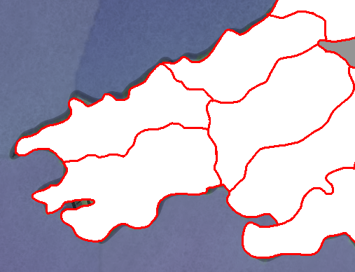
It has been noted by Dave however that this has been upped to 22 so far with additions in Powys and Carmarthenshire. There should therefore be room to expand on south Wales further even if slightly, to maintain a similar balance of locations, as the divide between North and South Wales is somewhat stark too, with the North having 6 locations to the South’s 4. I would therefore suggest the separation of Swansea into Swansea and Neath, with Swansea representing more the Lordship of Gower than the borders of the modern county.
1747262523320.png

Newer location map as of this thread shown by Dave

I would suggest 4 locations to even the playing field somewhat, add more flavour to South Wales and enable more interesting movements, these locations would interact with impassables which would be delved into in another section of this post.

South Wales - Swansea/Neath Split and a Newport Location
Firstly, as South Wales is seemingly the least populated, I would suggest a split of Swansea into Swansea and Neath, following the borders of the Lordship of Gower and remnants of the location being assigned to Neath, representing the density of the South better.

1747263429661.png

Swansea Neath Split

Secondly, I would suggest once again the creation of a location for Newport which eats into the current locations of Caerphilly, Monmouth and Cardiff, representing in part not only the historic nature of the city but also the Stafford Lordship of Gwynllwg and the Mortimer Lordship of Caerleon as well as once again representing the density of South Wales better.

1747263440852.png

New Location of Newport/Caerleon

The newly proposed South Wales therefore would look somewhat like this, with the Brecon Beacons subject to further discussion in the impassables section.

1747268381705.png
1747268392443.png

Existing vs proposed South Wales


West Wales (1) - Location of Narberth/Laugharne/Llansteffan
Firstly in West Wales, I would propose once again a location representing either Narberth or Laugharne or Llansteffan as a means to better reflect the nature of the Landsker line as well as a more accurate version of the borders of the Principality of Wales, eating into the Pembroke location somewhat as well as Fishguard (to which Carmarthen should also gain land in). The addition of this location should ideally be alongside the better representation of the three river confluence of the Towy estuary. Carmarthen had ample access to the ocean at the time, being a flourishing port town with access to the ocean via the Towy river, guarded upstream by Llansteffan Castle

1747264231943.png
1747264318278.png

1) Carmarthen Port located to the bottom of the above image, 2) The View of the Towy estuary from Llansteffan Castle

1747264697276.png
1747264710091.png

Existing as shown by Dave via this thread vs Proposed
(Note that the new location of Narberth/Laugharne/Llansteffan eats into Fishguard slightly in the top right, whilst the location of Carmarthen likewise eats into the Fishguard location, representing the Newcastle Emlyn region of the Teifi Valley controlled by Carmarthenshire for quite some time and redistributing location size more evenly)


In adding this location, the boundary of the invading Flemish/English settlers becomes clearer, as the Landsker line formed as a clear and stark contrast between the communities located either side for many centuries. Such an inclusion would also enable a more dynamic movement in the region, as with a clearer Tywi estuary, the importance of Carmarthen is exemplified, any access west or east would first require travelling through Carmarthen, elongating walking distance slightly between Pembroke and Carmarthen as well as forming more coherent traditional boundaries of both Pembrokeshire and Carmarthenshire respectively.

I also note that Carmarthen is no longer shown as being part of the principality of Wales via the latest update, the redesign of the borders should enable a more accurate depiction of the principality, with the Carmarthen location being a critical location to the southern regions.


West Wales (2) - Correction of the Ceredigion/Carmarthenshire border
This one may be somewhat small, but necessary to accurately depict the region. The shape of the Carmarthen-Cardigan boundary is rather off, with Carmarthen eating into much of the Ceredigion portion of the upper Teifi valley, likewise, Ceredigion has eaten much of the Carmarthenshire side of the middle Teifi valley, forming an elongated Ceredigion border, merging into an oddly shaped impassable state (to be raised later)

1747263710815.png
1747263715042.png

Existing vs Proposed

1747263735155.png

Proposed + terrain map overlay.


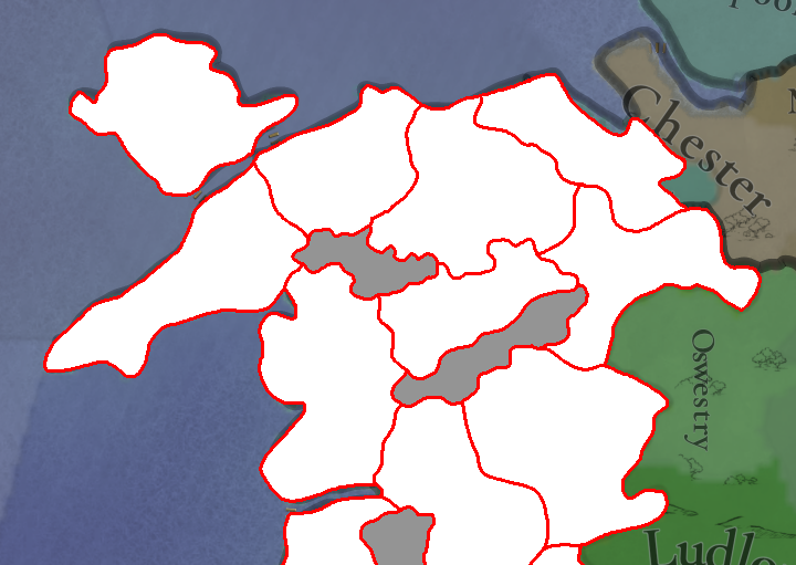
North Wales - Penllyn Location and correction to Flintshire boundary
Now that Dave has confirmed that Harlech has expanded to represent the Penllyn area of the Principality better, I believe it necessary to split the historic area/cantref of Penllyn from Harlech to highlight the importance of the area as a crossroads in the region. The inclusion of this location makes movement in North Wales more accurate, depicting the Glacial Valley to which the town of Bala is central. Bounded to the North-west by the Migneint Uplands and to the south by the Berwyn Mountain range.

This region was an important military route travelled by Glyndwr on his way South during the lead up to the Battle of Hyddgen, as he was perused by the Justiciar of North Wales. It is also said that the eastern portion of this location is where Glyndwr was attacked by a force led by his Cousin Hywel Sele at Nannau.

The existing impassable through the region is somewhat puzzling, as the locations representing Corwen and Llangollen cannot interact with Denbigh (which contains Ruthin). This cuts off the naturally low laying terrain linking the upper Dee Valley and Clywedog valley. The cause of the War of Independence was border disputes in the area between Glyndŵr and the Lord of Ruthin who illegally seized land, Glyndŵr then marched through what would be impassables ingame up from Corwen to Ruthin on his march of 1400.

1747265265559.png
1747265272918.png

Existing vs Proposed.

1747265476782.png

Glyndŵr's 1400 campaign through the area.

The Flintshire boundary at current is anachronistic, representing the modern boundary. The traditional boundary of Flintshire extended further north-west than the current boundary which was formed only in 1996. The current location is also too large to the east, seemingly containing the city of Chester, I believe the cause of this is the lack of representation for the canalisation of the river Dee in the 1700s, which eventually caused a reclamation of land which currently forms the portion of Wales North of the River, something which I had mentioned previously.
1747267217191.png
1747267264335.png

Traditional boundary vs modern 1996 boundary of Flintshire.

The proposal therefore is for an increase in size for Flint, with Denbigh consuming much of the reduntant impassable. This has the unintended benefit of accurately reflecting the historic county of Denbighshire to a certain extent also.
1747272678389.png
1747272683154.png

Existing vs Proposed

1747267572173.png


Impassables:
South Wales (Afan Forest and the Beacons)
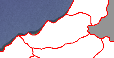
I understand that the impassable currently formed within South Wales is a means to highlight the undulating nature of the Afan forest and portions of the Brecon Beacon, however the extent is a little too much in my opinion and cuts across major logistic routes of the period.

Subjected to this impassable range are the locations listed as Kidwelly and Brecknock. Whilst it’s true that the area is heavily undulated, the stretch between Llandovery and Brecon remained one of the most crucial military passages for both the Roman period as well as during the conquest of Wales, especially around Trecastle, remaining the frontier between much of the marcher lords and the native princes and later forming a Turnpike Road.
1747262129114.png

Llandovery-Brecon path

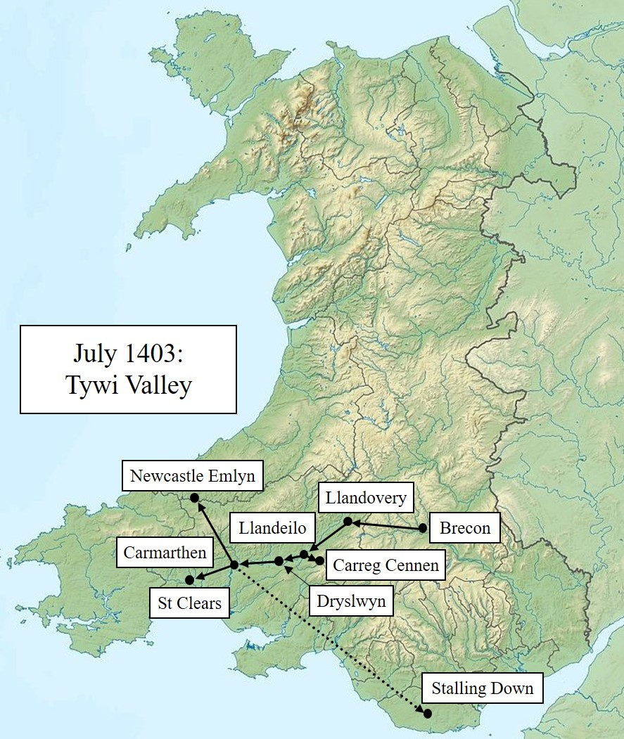
During the last war of Independence (Glyndŵrs revolt) it was noted that the second royal expedition into Glyndŵr held Wales in 1402 utilised this route to attack Carmarthenshire under the lords Stafford, Warwick and Arundel), both ways by the expedition of 1403 (there and back), Glyndŵr's 1403 offensive, as well as by the army of Rhys Ap Thomas in the lead up to the Battle of Bosworth.
1747262061984.png
1747262070567.png
1747262648200.png
1747262076920.png

Military campaigns utilising the path, namely the royal expeditions of 1402 and 1403, Glyndŵrs use of the path and the march of the Tudor forces to the Battle of Bosworth

Furthermore, a Roman Road ran through the Vale of Neath to the Roman fort of Nidum (Modern day Neath) towards Brecon which was also utilised throughout the Middle Ages and the length of the game’s timeframe, forming part of what is known as Sarn Helen.
1747262165099.png


Both areas can be seen in the following map highlighting Roman Roads in Wales:
1747262387477.png


I would suggest rather than this large area, an impassable range reflecting the black mountains instead, which though smaller, would represent the impassability of this part of the Brecon Beacons. I would suggest that the entirety of the Beacons be made impossible, however the route from Cardiff, through Caerphilly to Brecon was well established and the representation of eastern portions of the Beacons would prove a bit pointless as without the inclusion of further locations in the south, all existing locations would connect regardless of the impassable.....though of course one could be there for aesthetic purposes.

Alternatively, if accepting the slight redesigning south Wales to include the Swansea/Neath split and the addition of Newport, it would be feasible to add an eastern portion of the beacons that would have a meaningful impact ingame, preventing access from Newport to Brecon, but still enabling access from Caerphilly to represent the old Roman Road. This would broadly correspond with the entire Brecon Beacons with a connection between Caerphilly and Brecon via what is now the A470 at Storey Arms and Nant-ddu.
1747261959133.png
1747261971821.png

Current Impassable set up vs proposed with 2 Brecon beacon Impassable and 2 new locations as noted prior:


Mid Wales - Desert of Wales
Only a small one, the Desert of Wales at current is shown as being quite thin and hooked like, not really representing the accurate shape of the highland area visible by terrain and satellite imagery. The proposed in this instance works in conjunction with the redesign of the Ceredigion/Carmarthenshire border to form a more realistic looking Desert of Wales.

1747270098005.png
1747270105933.png


North Wales - Berwyn Mountains and the Migneint Uplands

I note that the Berwyn mountain range is now in-game in Dave's latest posts, but also note that some impassable to the North has been added, this seemingly corresponds to a slight degree to the undulating terrain surrounding the Tryweryn reservoir, however, extends almost 16.5 miles beyond. The area seemingly cuts across the Upper Dee and Upper Conwy valley areas, low lying terrain which has been settled for centuries.

Should devs wish to keep this impassable to an extent, I would suggest that this be broadly represented by the zoning of the Migneint-Arenig-Dduallt Special Area of Conservation as well as the Moelwynion mountain range north of Blaenau Ffestiniog. Depicted below is the Migneint SAC, as well as the Berwyn and South Clwyd Mountains SAC, mapping of the Berwyn Impassable could also follow this Special Area of Conservation should Devs find it handy and wish to replicate.
1747270849486.png

Migneint-Arenig-Dduallt and Berwyn and South Clwyd Mountains Special Areas of Conservation

Conclusion:
In adding the 4 suggested locations, the location density in Wales would match that of other regions depicted via this Tinto Talks EUV Dev Diary, notably Ulster and other regions of Ireland. South Wales at current is greatly under-populated in terms of locations and the inclusion of the proposed allows for a more accurate depiction of impassable's within the region, notably the Brecon Beacons.

In altering Pembrokeshire, Ceredigion and Carmarthenshire as proposed, the area would be much more capable of representing the Principality of Wales in an accurate way, whilst the pivotal importance of Carmarthen as a logistical and military hub for the region would be amplified.

Alterations to North Wales via the splitting of Harlech into Harlech/Penllyn (or Bala, makers pick I guess) as bounded by the more accurate impassable regions would enable a more historically accurate depiction of unit movements through North Wales in conjunction with the slight redesign of the Denbigh and Flint locations to represent the Historic areas of Flintshire and the northern portion of Denbighshire more accurately.

Lastly, find below the existing as depicted via this dev diary and updates found within compared to proposed alterations in this thread as well as what the Principality would look like were these updates included (Wastelands controlled slightly coloured also):
1747271915002.png
1747271924351.png
1747272248284.png
 
Last edited:
  • 11Like
  • 4
  • 3Love
  • 2
Reactions:
My man, I'm not spamming, literally all I was doing was responding to your questions. EDIT: NVM, you said we, fair enough.

I started by asking the devs if the Scots-Irish/Ulster Scots would be represented in any way, that's all. I wasn't advocating anything. If the answer had been "No," that'd be that. And I wasn't necessarily advocating for an event. You said, "Idk if there'd be events because everything is up to change. Like you'd have to create them yourself mechanically," so I just gave an example of how you could make such an event. I don't know if that's the best way to do it (I trust the devs to have a better understanding than I do) even if you want to be that hands on.

I was literally saying it was not a suggestion, just an example of how it could be done. I have not, and am not, suggesting anything. Just asking if Ulster Scots (or however you prefer to refer to the Scots that settled in Northern Ireland following the Plantations) will be represented in some way. Yes, this would have to be after the start of the game, though it would not necessarily have to be 300 years after (unless we want to... railroad it to be the case;))

Personally, I wouldn't classify that as railroading. There were multiple plantations of Ireland by England, not just of Ulster, from like 1500s onward. Would not be beyond the pale to have a way of recreating them in some way, assuming you are an England player controlling Ireland (plus maybe some other qualifiers) by event or some other mechanic. That said, everyone has their own limit of where it goes from not railroading to railroading, so I'm happy to drop that.
Was that beyond the pale comment a double entendre given the pale of Ireland?
 
  • 1Like
Reactions: