• We have updated our Community Code of Conduct. Please read through the new rules for the forum that are an integral part of Paradox Interactive’s User Agreement.

Mingmung

General
35 Badges
Aug 23, 2014
2.127
1.922
  • Europa Universalis IV: Art of War
  • Europa Universalis IV: Conquest of Paradise
  • Europa Universalis IV: Wealth of Nations
  • Europa Universalis IV: Res Publica
  • Europa Universalis IV: Cossacks
  • Europa Universalis IV: Pre-order
  • Crusader Kings II: Conclave
  • Europa Universalis IV: Mare Nostrum
  • Hearts of Iron IV: Cadet
  • Crusader Kings II: Reapers Due
  • Europa Universalis IV: Rights of Man
  • Crusader Kings II: Monks and Mystics
  • Europa Universalis IV: Mandate of Heaven
  • Europa Universalis IV: Third Rome
  • Hearts of Iron IV: Death or Dishonor
  • Europa Universalis IV: Cradle of Civilization
  • Hearts of Iron IV: Expansion Pass
  • Europa Universalis IV: Rule Britannia
  • Europa Universalis IV: Dharma
  • Crusader Kings II: Holy Fury
  • Europa Universalis IV: Common Sense
  • Crusader Kings II: Way of Life
  • Crusader Kings II
  • Europa Universalis IV: El Dorado
  • Cities: Skylines Deluxe Edition
  • Cities: Skylines
  • Victoria 2
  • Europa Universalis IV: Call to arms event
  • Europa Universalis IV
  • Crusader Kings II: Sword of Islam
  • Crusader Kings II: Sunset Invasion
  • Crusader Kings II: Sons of Abraham
  • Crusader Kings II: The Old Gods
  • Crusader Kings II: Legacy of Rome
  • Crusader Kings II: Charlemagne
Hello there,

Some feedback for Poland and Romania. If the devs want a more 'correct' Poland/Romania (at least one without mistakes), then they could just copy this work. I took great care to place the towns in the correct locations, I mainly used Google Maps for this, but also historical maps like these ones:
- https://upload.wikimedia.org/wikipedia/commons/9/97/Podział_administracyjny_I_RP.png
- https://upload.wikimedia.org/wikipedia/commons/6/6a/Partitions_of_Moldavia.jpg
- https://upload.wikimedia.org/wikipedia/commons/4/4e/Tara_Romaneasca_judete_1601-1718.svg
index.php

#1 Notec: The Notec is a Polish river, it doesn't make sense as a province-name. The Prussians used the German name (Netze) for a district there when they conquered it, but the Polish never did. The current capital of this province is Notec (it was Bydgoszcz before, but this city isn't located here, but in the province of Inowroclaw), but the Notec is a river, as mentioned earlier. The capital and province-name should be Naklo (nad Notecia).

Sources:
- https://en.wikipedia.org/wiki/Netze_District
- https://en.wikipedia.org/wiki/Nakło_nad_Notecią
- https://en.wikipedia.org/wiki/Noteć

#2 Inowroclaw: The current capital of Inowroclaw is Inowroclaw (2), but the location is actually that of Bydgoszcz (1). The position of the town of Inowroclaw should be changed to the correct one (2).

#3 Kujawy: The capital of Kujawy is currently Wloclawek (2), but it's actually in the incorrect position and should arguably be Brzesc-Kujawski (1), which was the seat of the voivodeship. So, I suggest renaming the capital to the latter and placing it in the correct spot.

#4 Tarnow: The capital is still in the location of another city; Rzeszow. I moved it to the correct location.

#5 Przemysl:
Moved the capital of Przemysl (1) a little bit. Also took off a chunk of the province itself and gave it to Lwów. Drohobycz (2) is actually located within the confines of this province instead of its own province.

#6 Lwów:
The capital-city isn't located within the current province. Moved the capital to the correct location right beneath the town of Belz. Had to chip away a bit of Przemysl to do this.

Source:
- https://upload.wikimedia.org/wikipedia/commons/9/97/Podział_administracyjny_I_RP.png

#7 Halicz:
Renamed this province to Halicz and moved the city a bit to the right position. This is currently still the province of Drohobycz, but that town wasn't located here.

#8 Kolomyja:
Kind of the same situation as the one above; Renamed this province to Kolomyja and moved the city a bit to the right position. This is currently still the province of Halicz, but that town wasn't located here. Also took a bit off this province and gave it to Suceava (Moldavia), as the important town of Cernauti isn't even located there currently. It was incorrectly drawn in the basegame of EU4. The town of Kolomyja was sometimes contested between the Polish kings and the Moldavian voivodes.

Sources:
- https://en.wikipedia.org/wiki/Kolomyia
- https://en.wikipedia.org/wiki/Chernivtsi [/SPOILER]

index.php

#1 Severin: Took a small bite away around the river for Ottoman-controlled Vidin. Otherwise, nothing has changed.
#2 Craiova: The current name (Oltenia) makes no sense if the historical area has been split into two provinces (one of which is Severin). So, renamed it to Craiova, its capital. Also moved the town a little bit.
#3 Tirgoviste: Nothing has changed.

#4 Ilfov/Bucuresti:
Modern-day Romania does indeed have a country which is called Giurgiu and the town/stronghold did indeed exist and was of importance on the Danube. Only one slight problem here; it was conquered by the Ottomans around 1417, to control traffic on the Danube. I'd personally change the capital and name to Bucharest. Vlasca or Ilfov might be better names for the province itself, though, with Bucharest as capital. I know it didn't exist yet, but so have more cities in EU4 (like Sulimaniyeh in the Kurdistan region). Bucharest is more than important enough to warrant some attention, it even has its own mission.

Anyway, Giurgiu makes zero sense and is a modern mistake.

Sources:
- https://www.britannica.com/place/Giurgiu-Romania
- https://upload.wikimedia.org/wikipedia/commons/4/4e/Tara_Romaneasca_judete_1601-1718.svg

#5 Buzau: The location of the city itself is plain wrong, so fixed that.

#6 Suceava: Moved it to the right spot and took a chunk away from Kolomyja (already talked about above). Terrain should be woodlands or hills and it definetely needs some dynamic province-names.

#7 Iasi: Changed the shape to fit the historical divisions more, as well as the partitions. The city had to be moved to the correct location, too. The province is now entirely on the right bank of the Prut river.

#8 Birlad: It's name could use a slight change, namely to Bârlad. Only bit a little part of it and gave it to Iasi. Its current dynamic province-names are still the same as the ones the old EU4-province of Moldava had.

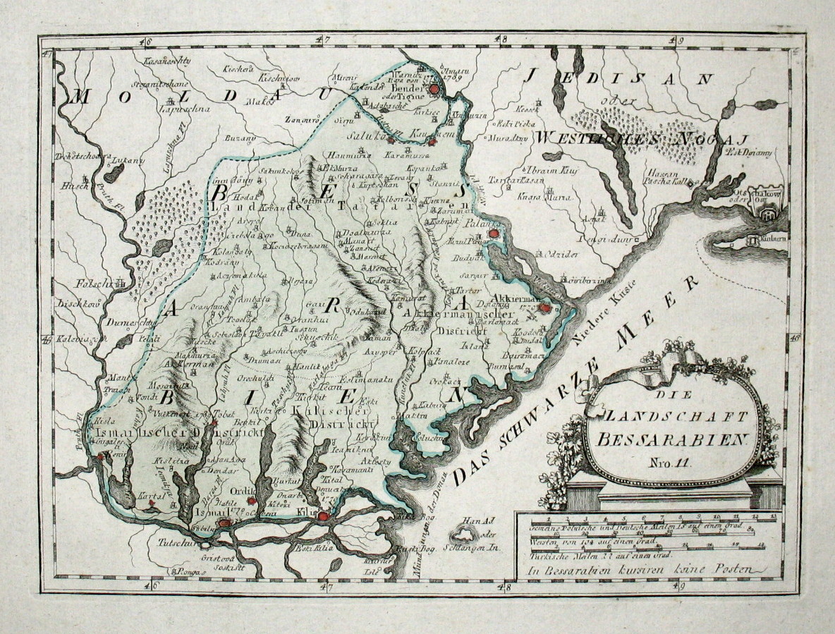
#9 Tighina: Elongated it a bit and gave its 'capital' (stronghold of Bender/Tighina) the correct spot on the map.

#10 Basarabia:
Moved the capital of Chilia to the correct position, as well as cutting the province at the Danube-delta to make way for an Ottoman-controlled Dobruja/Tolcu province.


Terrain-types (especially in Romania) and dynamic province-names (which are entirely lacking for all new provinces here) should be looked at in general, as well as the data for later start-dates. If you guys need more info/sources on those issues, I can provide that. Although it shouldn't be hard to find on the internet.

EDIT: Drohiczyn, Dobrzyn and Poznan have been fixed in the past few months.
 

Attachments

  • Poland (corrections and fixes).jpg
    Poland (corrections and fixes).jpg
    143,4 KB · Views: 1.532
  • Wallachia+Moldavia (corrections and fixes).jpg
    Wallachia+Moldavia (corrections and fixes).jpg
    85 KB · Views: 1.961
  • Poland (corrections and fixes).jpg
    Poland (corrections and fixes).jpg
    140,5 KB · Views: 588
Last edited:
Upvote 0
I can agree with that and would like to add some information.

poland.png

1 - Tarnopol, roughly estimated location. Most of Lwow province is actually Tarnopol and the Lwow itself is placed in Tarnopol in game.
2. Kołomyja as I estimate it location. Center of Halych province as it is in game. Notice that Halych city itself is a bit outside of the province somehow as Mingmung showed.
3. As
Mingmung showed, it is a proper location of Halych.
4. Proper location of Lwow as Mingmung showed. The province for Lwow should be rebordered and exclude Tarnopol.
5. As Mingmung showed, it is a proper location of Drohobytsj.
In the Red Ruthenia I highlighted with green the proper city locations as @Mingmung stated and added a bit more as per comment under the picture.
I suggest a following fix
  • join Drohobytsj and northern Halych, with a center in Halych, in one province named Halych
  • turn southern Halych into Kołomyja province (which would also play a role of Cernauty province for the Poland partition borders as some people wanted)
  • expand Lwow by taking eastern parts of Przemysl and northern Drohobytsj provinces
  • cut off Tarnopol province from Lwow
It would create 6 provinces in a state, however as a solution for it Tarnopol province could be give to Volhyn, while Podolia Volhynia state would be separated into two parts. Or, alternatively, develop the region of Bessarabia and Moldova and include Kolomyja in it. In worst case, if the state changes would be impossible, the borders of Lwow province should be readjusted in somewhat another way. As of now, it looks like Tarnopol is the center of the Lwow province.
Here are possible suggestions:
Warning: contains very crude borders, rectangularisms and has other issues. These are nothing but the outliers for the futher improvements, visual directions of how borders should be reworked.
red ruthenia +tarnopol.png
Red Rutheniea with Tarnopol. Does look better, but has 6 provinces in a state.
red ruthenia +tarnopol v2.png

Another rough sketch for it, with a bigger (Volhynian?) Tarnopol province. Obviously, borders aren't perfect and are rectangular in my execution.
red ruthenia -tarnopol.png

Tarnopolless map. No extra provinces.
red ruthenia -tarnopol v2.png

And the last version: No Tarnopol, No Drohobych. Halych replaced with Kolomyja, Drohobych is replaced with Halych, Lwow expanded to incorporate the city site, Kolomyja gets a bit of Lwow, Przemysl loses a bit of territory.
All these versions are mostly outliers and not the actual maps.

I highlighted the capital of Halych province as it coincides with a location of Kołomyja, one of the important cities in the Red Ruthenia which also had a regional trade relevance and served consistently as a trade route between Moldova and Poland. In the XV century city was at times under the control of Moldova due to the debt and the effective control over the place belonged to Moldova (which is an interesting flavour event and a possible interest to Moldovan idea/missions). The city was a place where the salt was produced and also a target for the Tatar raids as quite a lot of riches passed through it. The city of Chernivtsi (Cernauty or whatever other names it has) is also in that province (however, it was not relevant at all at the time), so having Kołomyja as a separate province in a part of Halych would give that place more dynamics, the historical ties to the Moldavia, would make Red Ruthenia better... and, how quite a few people wanted, would make more possible to realize borders after the partition of Poland. In short, it would be great to feature Kołomyja province as separate.
Another thing is Tarnopol. Most of Lwow province is actually a damn Tarnopol and even Lwow itself is shown in the place of Tarnopol. Naturally, it begs to represent the town as a separate province, including the history the city had.
The last thing, but not the least: the bordering state of Podolia Volhynia is a Frankenstein.

All in all from this post:
  1. Lwow should be redrawn to contain Lwow.
  2. Please consider adding Tarnopol.
  3. Fix the cities as it was mentioned.
  4. Perhaps redo Halych into Kolomyja and Drohobych into Halych.
 
I can agree with that and would like to add some information.

View attachment 405537
1 - Tarnopol, roughly estimated location. Most of Lwow province is actually Tarnopol and the Lwow itself is placed in Tarnopol in game.
2. Kołomyja as I estimate it location. Center of Halych province as it is in game. Notice that Halych city itself is a bit outside of the province somehow as Mingmung showed.
3. As
Mingmung showed, it is a proper location of Halych.
4. Proper location of Lwow as Mingmung showed. The province for Lwow should be rebordered and exclude Tarnopol.
5. As Mingmung showed, it is a proper location of Drohobytsj.
In the Red Ruthenia I highlighted with green the proper city locations as @Mingmung stated and added a bit more as per comment under the picture.
I suggest a following fix
  • join Drohobytsj and northern Halych, with a center in Halych, in one province named Halych
  • turn southern Halych into Kołomyja province (which would also play a role of Cernauty province for the Poland partition borders as some people wanted)
  • expand Lwow by taking eastern parts of Przemysl and northern Drohobytsj provinces
  • cut off Tarnopol province from Lwow
It would create 6 provinces in a state, however as a solution for it Tarnopol province could be give to Volhyn, while Podolia Volhynia state would be separated into two parts. Or, alternatively, develop the region of Bessarabia and Moldova and include Kolomyja in it. In worst case, if the state changes would be impossible, the borders of Lwow province should be readjusted in somewhat another way. As of now, it looks like Tarnopol is the center of the Lwow province.
Here are possible suggestions:
Warning: contains very crude borders, rectangularisms and has other issues. These are nothing but the outliers for the futher improvements, visual directions of how borders should be reworked.
View attachment 405544 Red Rutheniea with Tarnopol. Does look better, but has 6 provinces in a state.
View attachment 405547
Another rough sketch for it, with a bigger (Volhynian?) Tarnopol province. Obviously, borders aren't perfect and are rectangular in my execution.
View attachment 405548
Tarnopolless map. No extra provinces.
View attachment 405549
And the last version: No Tarnopol, No Drohobych. Halych replaced with Kolomyja, Drohobych is replaced with Halych, Lwow expanded to incorporate the city site, Kolomyja gets a bit of Lwow, Przemysl loses a bit of territory.
All these versions are mostly outliers and not the actual maps.

I highlighted the capital of Halych province as it coincides with a location of Kołomyja, one of the important cities in the Red Ruthenia which also had a regional trade relevance and served consistently as a trade route between Moldova and Poland. In the XV century city was at times under the control of Moldova due to the debt and the effective control over the place belonged to Moldova (which is an interesting flavour event and a possible interest to Moldovan idea/missions). The city was a place where the salt was produced and also a target for the Tatar raids as quite a lot of riches passed through it. The city of Chernivtsi (Cernauty or whatever other names it has) is also in that province (however, it was not relevant at all at the time), so having Kołomyja as a separate province in a part of Halych would give that place more dynamics, the historical ties to the Moldavia, would make Red Ruthenia better... and, how quite a few people wanted, would make more possible to realize borders after the partition of Poland. In short, it would be great to feature Kołomyja province as separate.
Another thing is Tarnopol. Most of Lwow province is actually a damn Tarnopol and even Lwow itself is shown in the place of Tarnopol. Naturally, it begs to represent the town as a separate province, including the history the city had.
The last thing, but not the least: the bordering state of Podolia Volhynia is a Frankenstein.

All in all from this post:
  1. Lwow should be redrawn to contain Lwow.
  2. Please consider adding Tarnopol.
  3. Fix the cities as it was mentioned.
  4. Perhaps redo Halych into Kolomyja and Drohobych into Halych.
Thank you for your great suggestion, I can't agree more. Podolia is indeed quite messy, too. But I don't know if it should be changed as it would throw the entirety of Ukraine and Moldavia in jeopardy. So, maybe a sloght relocation, but I guess we just can't fix it 100%.

I put some ???? there on the map, because I wasn't sure how to deal with it properly.
 
Podolia is indeed quite messy, too. But I don't know if it should be changed as it would throw the entirety of Ukraine and Moldavia in jeopardy.
My idea would be redrawing Ruthenia and abandoning some awful regions like "Podolia Volhnia" - and it should be done for the whole Ruthenia for it to make sense. The very absence of Uman and Bila Tserkva is heartbreaking while Cherkasy is a very big province and it encompass a lot of important places at once.

I also thought a bit and one of the options for including Tarnopol in Red Ruthenia region would be putting Belz in Volhnia.
As Belz was a separate voivodeship from the Lwow, that would be in line with historical plausability. That way Red Ruthenia region would maintain no more than 5 provinces and Volhnia would start to shift from Podolia, allowing to cede Podolia from that region less painfully in the future and redevelop it within fixing Ruthenian borders.

I do not fully know how would the new regions turn out, but looking at the new map I would say that it lack the following towns which would be provinces in future:
fix ruthenia.png

All locations are just a draft of a suggestion, the precise locations may be a bit different.
1 - Bila Tserkva, an important Ruthenian city which played a huger role than Zhytomyr.
2 - Kaniw. Admittedly, it is more of an optional idea, one of the possible solutions to making Cherkasy province too big and encompassing too much.
3 - Uman. An important town in Podolia region, without which the region loses a lot. I strongly recommend adding it.
4 - Chyhyryn. An important city, which with other cities in the region, especially for Cossacks.
5 - Zolotonosha. Would recommend to add to make left bank less chunky and to make it properly divided.
6 - Baturyn. It is a damn shame it is still no in the game.
7 - Mirgorod. An important city.
8 - Kremenchuk.

However, I myself would only strongly recommend adding Uman province if possible as of now without reworking Ruthenia (and, well, Poland in Immersion pack). The fact how Tatar raids worked and naturally "nerfed" Poland and Ruthenia, the Cossacks issues and such are needed to compensate for making Ruthenia have more provinces - and it would be fair for the region which wasn't like some wastelands (which have more detailed provinces), but constantly plundered and suffering from war attritions.
 
Last edited:
Let's just hope they'll tweak the provinces before the patch hits, as it would be a shame if this region stays incorrect for years.


I'm of the opinion that upcoming map changes should be as thorough as possible, because EU4's dev cycle won't be endless. Unfixed mistakes would just be sad.
 
Let's just hope they'll tweak the provinces before the patch hits
I agree, hopefully something can be done. I've posted a suggestion map for representing more provinces (not all of them of course, but part of those could be actually used, especially Uman which is in my opinion crucial to Podolia.
 
I agree, hopefully something can be done. I've posted a suggestion map for representing more provinces (not all of them of course, but part of those could be actually used, especially Uman which is in my opinion crucial to Podolia.
Is the placement of the provinces of the Grand Duchy correct, by the way?

Another point, I think we should go for the last Tarnopol-less map, as Tarnopol was built in the 16th century and didn't exist in 1444.
 
Last edited:
So, here's my map for Romania:
Wallachia%2BMoldavia%20update.png


I'll start with #1 Giurgiu: Modern-day Romania does indeed have a country which is called Giurgiu and the town/stronghold did indeed exist and was of importance on the Danube. Only one slight problem here; it was conquered by the Ottomans around 1417, to control traffic on the Danube. I'd personally change it to Bucharest (the red circle above the number #1).
Tara_Romaneasca_judete_1601-1718.svg

Vlasca or Ilfov might be better names for the province itself, with Bucharest as capital. I know it didn't exist yet, but so have more cities in EU4 (like Sulimaniyeh in the Kurdistan region). And Bucharest is more than important enough to warrant some attention, it even has its own mission. This one really stands out, so I hope it will get changed!

Sources:
- https://www.britannica.com/place/Giurgiu-Romania
- https://upload.wikimedia.org/wikipedia/commons/4/4e/Tara_Romaneasca_judete_1601-1718.svg

#2 Buzau: The location of the city itself is plain wrong, just look at the map above here. That's all for Wallachia, really. Craiova, Targoviste and Severin are all in the right spot, so that's great.

Sources:
- https://upload.wikimedia.org/wikipedia/commons/4/4e/Tara_Romaneasca_judete_1601-1718.svg

#3, 4, 5 and 6: Moldavia is sadly still a mess when it comes to borders and locations of cities. Just look at Google maps and compare the locations of the cities to the 1.27 version:
Moldavia%20-correct%20locations.png

The 1.27 map doesn't follow historical divisions at the slightest, so you guys might think about borders, too.

@neondt are you guys happy with the 1.27 map-update as it is, or are you guys really open for this kind of feedback and willing to implement it?

I hope a future Balkan-update will finally fix the border between the Dobruja and Bessarabia. Also keep in mind that Tighina became a regional name for the whole of current-day Moldova only when the Russians came, it was a much smaller administrative unit during the times of the Principality of Moldavia.
 
Last edited:
Is the placement of the provinces of the Grand Duchy correct, by the way?

It is correct. But 4 provinces MUST be renamed I think.

1) Rivne should be renamed into Lutsk (Luckas).
Lutsk was political capital of Volhynia, largest and most important town during GDL & Commonwealth era. While Rivne was just casual town gaining importance only much later - in 18-19th centuries. It feels really not right when state is without its capital province (I guess Volhynia state is created now).

2) Ula should be renamed into Barysaw (Borisovas).
It's not that Barysaw was particularly important, but unlike Ula at least it had Magdeburg rights (self-governance) and was fairly large town. It also fits Minsk state much better and match Ula province boundaries - no redrawing needed. Ula has nearly no historical significance (just place of one important battle) and I guess not many Belarusians know what Ula is.

3) Upita should be renamed into Birzai.
As Lithuanian I can tell you - 99% Lithuanians don't know what Upita (Upyte) is. Yes, there was administrative division under Upyte eldership name, but in reality it was administrated from Panevezys right from 16th century when Grand Duchy Lithuania divisions were approved. Upyte is historical site where important castle once stood in Middle Ages, but castle was burned down and since 15th century Upyte is just a small village at most. Upyte name of eldership was kept till 19th century, but it's just a name which has no significance in Lithuanian history whatsoever. I can bring tons of literature on this, but simple Lithuanian wikipedia do explain things with ease - before 1565 / past 1565.
Now what is Birzai?
- Birzai is one of the richest and most significant historical sites in Lithuania, particularly for 16-18th centuries.
- Since 16th century Birzai was a private Duchy of Radvila family, the most powerful noble family in GDL. Duchy of Birzai included many lands in Upyte eldership, also northern parts of Vilkmerge eldership. City Kedainiai and few more close lands in Samogitia were also property of Radvila family.
- Birzai with Magdeburg Rights granted in 1589 was the only town in Upyte eldership with Magdeburg Rights before late 18th century. It wasn't big town mostly thanks to being border town under constant warfare, still both politically and economically it was the most important town by miles there. It had close trade ties with Riga and it is believed that there existed trade route from Birzai to Riga by waterways at the time.
- Birzai castle - bastion type castle, was the most modern castle in GDL at the time and was major fortress in wars with Sweden.

PLEASE Paradox do not humiliate our historical sites like Birzai with names which have no weight in Lithuanian history.

4) Zemaitija should be renamed into Raseiniai (or Varniai).
With all provinces named after towns, Zemaitija just do not follow same patern. I think it would be better is Zemaitija (Samogitia) was name for state, while province would be named after town.
The most obvious name would be Raseiniai. Raseiniai was administrative center of Samogitia, one of the largest and important towns altogether. With Magdeburg Rights granted in 1492 it had no serious rivals in this aspect.
Though historical heartland of Samogitia is actually not Raseiniai, but Varniai, town built on historical site of Medininkai. What's more interesting, it is fact that Varniai had self governance as early as Raseiniai - from 1491 under Kulm Law, and since 1635 under Magdeburg Rights. Since 1417 Varniai was also Bishopric center of Samogitia with a duty to convert all the last Pagans into Christians.
I had lots of different thoughts how to divide Samogitia province in the past myself, but now answer is clear - Raseiniai (Southeast part) and Varniai (Northwest part).


Advice on Lithuanian States

GDL should have 2 Lithuanian states - Samogitia & Lithuania.

1) Samogitia State
  • Raseiniai
  • Varniai (Clergy Estate)
  • Birzai (Noble Estate)
  • Kaunas
Until 18th century lands of Samogitia were considered lands north of Neman and west of Sventoji rivers (west of Vilkmerge, that is Birzai/Upyte province still part of Samogitia). Kaunas administrated historical lands of Sudovia (Lithuanian part) which technically isn't part of Samogitia but I don't see where else they could be included.

2) Lithuania State
  • Vilnius
  • Trakai (moved to Samogitia State if 5-province cap reached in Lithuania State)
  • Vilkmerge
  • Asmena (Ashmyany)
  • Breslauja (Braslaw)
  • Lida
I just want to highlight fact that Trakai was always considered as part of historical Lithuania, not Samogitia. Lithuanians (aukstaiciai) are identified as Baltic tribes living in highlands (small hills) of East Lithuania / West Belarus. Samogitians (zemaiciai) were Baltic tribes living in lowlands of Northwest Lithuania. Just look at geographical map of Lithuania, it's easy to understand. Overall both Lithuanians and Samogitians were same people.
Trakai eldership (Powiat) administrated lands nowadays known as Dzukija in Lithuania, and Dzukija is land of "Southern Lithuanians" which lived on higher ground.
LithuaniaPhysicalMap-Detailed.png


Overall very nice and unexpected update from Paradox!
If only I knew this coming, I would have made great suggestion on provinces for GDL some time ago. I have big work on the way and will present it at some time nevertheless :)
Eitherway all provinces added to Grand Duchy Lithuania are fine and very reasonable. Just fix few province names :)

@neondt
 
Last edited:
Last edited:
So, here's my map for Romania:
Wallachia%2BMoldavia%20update.png


#3, 4, 5 and 6: Moldavia is sadly still a mess when it comes to borders and locations of cities. Just look at Google maps and compare the locations of the cities to the 1.27 version:
Moldavia%20-correct%20locations.png

The 1.27 map doesn't follow historical divisions at the slightest, so you guys might think about borders, too.

@neondt are you guys happy with the 1.27 map-update as it is, or are you guys really open for this kind of feedback and willing to implement it?

I hope a future Balkan-update will finally fix the border between the Dobruja and Bessarabia. Also keep in mind that Tighina became a regional name for the whole of current-day Moldova only when the Russians came, it was a much smaller administrative unit during the times of the Principality of Moldavia.

The 1.27 prov borders projected on a map of historical Moldovia:
0QM2DeD.jpg


The game province of Tighina shoud be named Orhei (hungarian Varhely, russian/ruthenian Orgeev, polish Orgiejów), correctly to the location of prov capital. In 1538 the Ottomans forced prince Petru Rares of Moldavia to give up the fortress-city Tighina. From that moment Tighina was part of Budjak (Bessarabia), renamed as Bender was under ottoman rule till 1812, when was annexed by Russians.

Map_of_Bessarabia_in_1791_by_Reilly_011.jpg
 
The 1.27 prov borders projected on a map of historical Moldovia
Out of curiosity: What is "Moldovia"? It's not the first time I see this word. Is it just a typo or some sort of weird compromise between Moldavia and Moldova?
 
@neondt
@DDRJake
@Trin Tragula
In 1.27 Polish 1815 borders will be replaced by more historically accurate ones for the timeline of EUIV, can we do the same to Moldavia and end the Pruth River partiton of 1812?
The territories on which Moldavia was formed were made up of traditional three areas: sub-Carpathian highlands Tara de Sus, stretched to the Siret River; central Tara de Jos, lowlands between Siret and Dniester River; and the Pontic steppe of Basarabia (later Budjak), moldavian "Wild Fields", to the Black Sea.

My proposal of moldavian provs:
  • Suceava (Bucovina part of Tara de Sus region) - terrain: highlands, no estate, trade goods: livestock, main city Suceava, capital level 1 fort (later decision to move capital to Iasi?) The province borders with hungarian Maramaros (through mountain passes like Tihuta Pass)
  • Bacau (Siret River valley, part of Tara de Jos region) - terrain: highlands, controlled by the clergy estate, trade goods: wine, main city Bacau
  • Botosani (the rest of Tara de Sus region) - terrain: farmlands, controlled by the boyars estate, trade goods: livestock, main city Botosani, level 2 fort representing the border citadels of Hotin and Soroca
  • Iasi (the rest Tara de Jos region) - terrain: grasslands, no estate, trade goods: wine, main city Iasi
  • Basarabia (together with Tighina county) - terrain: steppes, controlled by the cossacks estate, trade goods: wool, main city Chilia
TD5CTce.jpg
 
Tighina/Bender already seems to be within the correct borders, only the location of the fortress itself within that province is off.
 
The point is Tighina really should follow historical path together with Basarabia prov, not Moldavia proper. Orhei / Lapusna / Soroca Counties (now in the same prov like Bender) were actually never annexed by the Ottomans.

During his reign of Moldavia, Stephen III had a small wooden fort built in the town to defend the settlement from Tatar raids. In 1538, the Ottoman sultan Suleiman the Magnificent conquered the town from Moldavia, and renamed it Bender. Its fortifications were developed into a full fortress under the same name under the supervision of the Turkish architect Koji Mimar Sinan. The Ottomans used it to keep the pressure on Moldavia.
I'm well aware, but I just posted the suggestion that would cost the least amount of work for the devs while still being accurate for the 1444 time-stamp.
 
Is the placement of the provinces of the Grand Duchy correct, by the way?
Mostly yes. Like I said, some important towns like Uman and Bila Tserkva should be represented on the map, as well as as Rivne indeed should be called Lutsk as @BalticM said. I also think that the Left Bank (east to Dnieper) is still way too sparse - some important historical locations like Baturyn and such as I mentioned above should be there.

Anyway, here are Lithuania-Ruthenia fixes I can talk about. I'll leave most of the territory of modern Belarus aside since I lack knowledge about their administrative divisions, especially historical.

fix odesa.png
Well, let me start with Odesa. As the biggest Ottoman fort there and the location of the biggest interest for the most part of the EU4 timeframe, I suppose that they mean Khadjibey as a province capital. I mean, what else could/should be it be? The location is fixed as it is a bit off.
As a secondary question I would like to know why Dniester Estuary is not represented. It is a damn gulf, albeit shallow, which is not passable even nowadays. Here is a photo to understand how big it is, it is actually big enough that it separates Edisan and what is called Budjak nowadays (aka that southern Moldovan province).
Dniester_liman.jpeg
I have no idea what is that town in Yedishkul. There is basically a steppe even nowadays and small settlements.
I have 0 idea why that part of Donbass is called Mansur. Mansur duchy/principality was far more in the north, in the severian lands - in the territory of Poltava, Sumy and western Kharkiv regions. They were the founders of the influential Hlinsk noble family, their descendants played a big role in the Lithuanian duchy, their ancestor (Mamay) is a part of a folk culture and a legend.
This said, I will repeat what many people said before: Ryazanian culture is an ahistorical term. What is that supposed to be? There was a Severian culture and it makes way more sense. What is the reasoning behind this name?
I have no idea why Kyzyl-Yar is called that, maybe there is some logic I miss, but I don't recall that name being in historical annals.
Now, the last thing - in the Golden Horde. Bahmut? Why is it called like that? I know that there is Bakhmut in the province EU4 calls Mansur, standing on the Bakhmut/Bakhmutka river, and the city was founded in XVI century.

Given the issue with Mansur and Severian culture being called Ryazanian, I think that these are very important things to fix. It is humiliating that even Eastern Africa has more proper cultural divide and names than Eastern Europe. Not to mention province density - and even if we count in Wild Field, it is still less dense than Ogaden. Ruthenia is less province-wise represented than Poland, Muscovy and East Africa, it definitely needs some love! Otherwise, the region misses a huge chunk of history and a reason why XVII century turned out to be very brutal for everyone and especially for Commonwealth.
Realistically, I have my doubts that Ruthenia will get a rework in EU4 and so lets just fix Mansur, Severian culture, Dniester Estuary and other things if possible.