• We have updated our Community Code of Conduct. Please read through the new rules for the forum that are an integral part of Paradox Interactive’s User Agreement.

Zerodv

Field Marshal
30 Badges
Dec 1, 2014
6.801
5.828
  • Europa Universalis IV: Art of War
  • Europa Universalis IV: Conquest of Paradise
  • Europa Universalis IV: Wealth of Nations
  • Europa Universalis IV: Call to arms event
  • Europa Universalis IV: Res Publica
  • Victoria: Revolutions
  • Victoria 2: A House Divided
  • Victoria 2: Heart of Darkness
  • Crusader Kings II
  • Europa Universalis IV: Third Rome
  • Europa Universalis IV: Cossacks
  • Hearts of Iron IV: Death or Dishonor
  • Europa Universalis IV: Cradle of Civilization
  • Hearts of Iron IV: Expansion Pass
  • Europa Universalis IV: Rule Britannia
  • Europa Universalis IV: Dharma
  • Europa Universalis IV: Golden Century
  • Imperator: Rome
  • Crusader Kings III
  • Europa Universalis 4: Emperor
  • Europa Universalis IV: Mandate of Heaven
  • Europa Universalis IV: Rights of Man
  • Hearts of Iron IV: Cadet
  • Europa Universalis IV: Mare Nostrum
  • Europa Universalis IV: Common Sense
  • Magicka 2
  • Europa Universalis IV: El Dorado
  • Victoria 2
  • Europa Universalis IV
  • Magicka
Tinto seems to have gone with a simplified version of the koppen system, while I won't argue at length why they should change now so far in development, I think it might be worth discussing alternate systems which either have simply more categories or fundamentally define climate using more modern metrics that Koppen himself didn't have.

Really this is about discussing this:


med.png


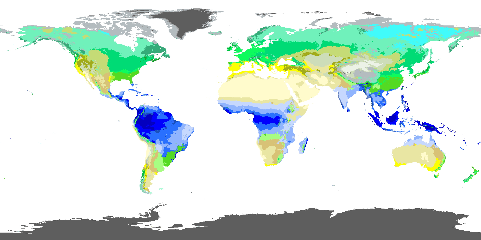
This is a worldbuilding blog and here the author discusses his own system to replace koppen and try to achieve its intended goal, meaning predicting biome. The reason behind this project is partially to let it be extendable for worldbuilding purposes but really this seems an outright improvement to me for earth too and most of the article discusses earth-like stuff.

These are the factors he uses and all of these can be readily calculated for earth(sources are readily available and I think the one I have has virtually everything):
MinT = Absolute Minimum Temperature(proxied with monthly average temperature of the coldest month)
Ar = Aridity Factor(from 0 to 1, 1 means less arid lol), well it's aridity
GAr = Growth-Adjusted Aridity Factor, measures how much moisture coincided with the warm/hot growth period
GINT = Degree-Days of Low Temperature(under 10C I think), measures the "cost" that non-cold adapted plant have to endure before swapping to a seasonal leaf shedding strategy
GDD = Degree-Days of Warm Temperature(above 5C I think), predicts how much tree can grow annualy
GDDz = Degree-Days of Cool Temperature(above 0C), predicts how much cold adapted non-tree plants can grow annualy
GS = Precipation Adjusted for Seasonality, measures how much plants rely on stored ground water or other environmental sources during summer drough

Not all climates here are necessary, I think the distinction between Tundra CFa and CFb or Ice Cap/Barren CG and CI to be pointless, sub mediterranean CMa and CMb are also questionable. The rest though seems worth considering and that's like 20 climates over the current 8.

I can't really add much without just paraphrasing what's written here. I hope this is of some use for any future modder.
 
Last edited:
  • 9Like
  • 5
  • 2
  • 1
Reactions:
no_pluv.png

Important to note the graph above and map here use the "second to last" step, meaning I didn't show pluvial vs non pluvial distinction as I didn't find them meaningful, but they are there for the last version if you are interested.

Also I really like how this model predicts the steppe in Eastern Europe quite well.
 
  • 3
  • 1Like
Reactions:
@Ispil maybe it's of interest to you?
I appreciate it. Personally I want to do my best to avoid touching the map unless necessary. Even for the stuff where I need to, I've got plans to minimize the amount of actual "map dependency" that I'll have by utilizing generated files.

In an ideal world someone else would make a mod that touches the climate setup and I'd just make my stuff compatible.
 
  • 2
Reactions:
The game is already not very good at applying the köppen system itself. But yes, I will probably make a mod when the game comes out that implements better climates, likely based on this system.
 
  • 3Like
Reactions:
It's an amazingly useful system for worldbuilding and exoplanet classifications, but I'm not convinced he invented an inherently superior system for applying it to Earth itself. However, it is a great, if not the best, coherent post on climate I've ever seen. (I also follow his blogposts with intent, he is incredibly knowledgable!)

The first entry in his series explores existing classification schemes a bit more, with nice details on what the strengths and weaknesses are for each system.
https://worldbuildingpasta.blogspot.com/2024/12/beyond-koppen-geiger-climate.html

When comparing the new scheme, apart from the use of a different color scheme, the results are honestly very similar to Koppen. Especially when stripping away the hyperpluvial zones, which he himself admits doesn't do all that much In terms of biome classification. For instance, apart from color use, the zonation in the steppes isn't all that different from Koppen as far as I can tell?
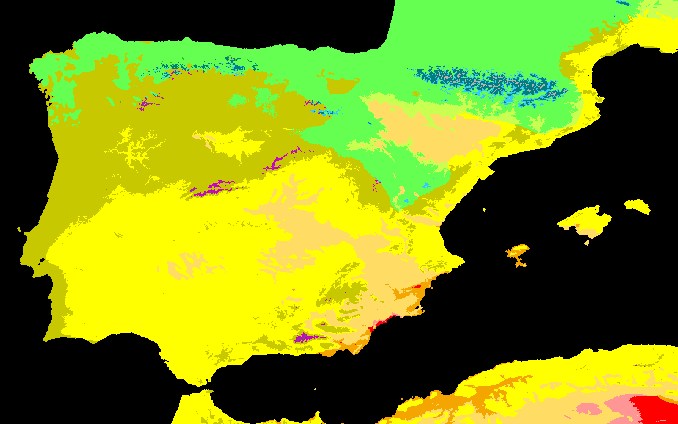
It also has similar pitfalls of Koppen where some specific climate zones lack granularity, like temperate and mediterranean zones (lack of climate granularity in Spain for instance).

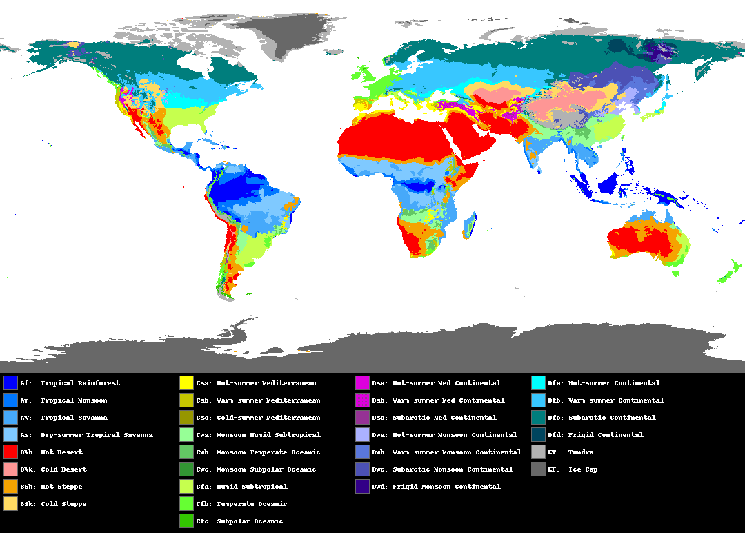
Nikolai's mapkoppen-geiger map with the same dataset
1745385653726.png
1745385718372.png

Another potential difficulty is how to extrapolate these classifications to the late medieval climate. The only source I've found that represents late medieval climate somewhat is the 1901-1930 koppen classification. With some luck they made the data available for recalculation, so that would be super useful.
Especially because Nikolai made his scripts publicly available to calculate each individual climate classification (including Koppen, Holdridge, Thewarta, Thornwaithe,...)
 
  • 10Like
  • 3
  • 1
Reactions:
It's an amazingly useful system for worldbuilding and exoplanet classifications, but I'm not convinced he invented an inherently superior system for applying it to Earth itself. However, it is a great, if not the best, coherent post on climate I've ever seen. (I also follow his blogposts with intent, he is incredibly knowledgable!)

The first entry in his series explores existing classification schemes a bit more, with nice details on what the strengths and weaknesses are for each system.
https://worldbuildingpasta.blogspot.com/2024/12/beyond-koppen-geiger-climate.html

When comparing the new scheme, apart from the use of a different color scheme, the results are honestly very similar to Koppen. Especially when stripping away the hyperpluvial zones, which he himself admits doesn't do all that much In terms of biome classification. For instance, apart from color use, the zonation in the steppes isn't all that different from Koppen as far as I can tell?
It also has similar pitfalls of Koppen where some specific climate zones lack granularity, like temperate and mediterranean zones (lack of climate granularity in Spain for instance).

Nikolai's mapkoppen-geiger map with the same dataset
View attachment 1284568View attachment 1284569

Another potential difficulty is how to extrapolate these classifications to the late medieval climate. The only source I've found that represents late medieval climate somewhat is the 1901-1930 koppen classification. With some luck they made the data available for recalculation, so that would be super useful.
Especially because Nikolai made his scripts publicly available to calculate each individual climate classification (including Koppen, Holdridge, Thewarta, Thornwaithe,...)
Important difference is the arid calculation, Central Asia goes from cold desert center with cold semi-arid band to a cold semidesert center with a steppe band, which to me seems a very major change.
Like for whatever reason using a non-arbitrary 0.5 Growth-Aridity predicts the "exact" steppe/forest steppe boundary in Eurasia, that is quite noteable.

Also semi-arid is removed in most of Spain and Turkey.

Another difference is removing monsoon climates in China which might be well justified if the impact on biomes is trivial in colder regions.

Also the evergreen conifer vs eastsiberian seasonal conifer distinction is also more exact while removing the pointless seasonal distinction that seemingly don't have a big impact on the plants that tend to have enough water available.

I will try to replicate the map with the EU5 resolution when I have time
 
  • 3Like
Reactions:
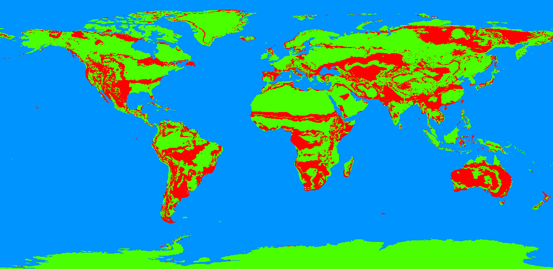
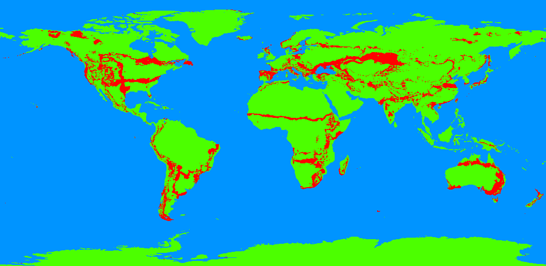
Overlaying his koppen vs his system, after consolidating both sides into similar categories this is the overlap and differnce. 25% of land area is different and that is counting antartica, imo it's a noticeable difference

1745390757430.png


1745391166828.png
 
Last edited:
  • 1Like
Reactions:
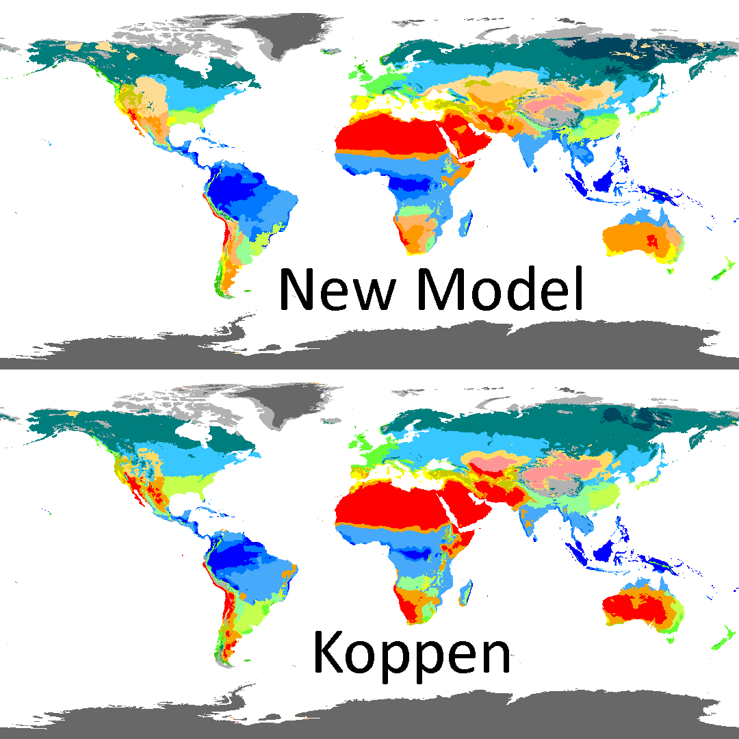
If you simplify both maps down to the Tinto's 8 categories, the difference goes down to around 10-15%, though I hope people can see the issue with just 8 categories
1745392027629.png
 
Last edited:
  • 2Like
Reactions:
  • 2Like
  • 1
Reactions:
If you simplify both maps down to the Tinto's 8 categories, the difference goes down to around 10-15%, though I hope people can see the issue with just 8 categories
View attachment 1284586
I think the lack of an arid vs semi-arid distinction is the biggest problem. Johan seems to think “cold arid” should mean Gobi Desert, but the practical outcome of this is eastern Spain being some unlivable hellscape nobody wants to migrate to, which describes the Gobi well enough but not Spain. That and the wanking of Mediterranean to be way better than it should be for no discernible reason beyond Johan is convinced that describes the local climate (even though Tinto is surrounded by cold arid and that one speck of Mediterranean will invariably be an edge case) even though if you look at population maps subtropical would appear to be at least as good if not better, with oceanic being not far behind, not lagging massively.
 
  • 8
  • 2Like
Reactions:
I think the lack of an arid vs semi-arid distinction is the biggest problem. Johan seems to think “cold arid” should mean Gobi Desert, but the practical outcome of this is eastern Spain being some unlivable hellscape nobody wants to migrate to, which describes the Gobi well enough but not Spain. That and the wanking of Mediterranean to be way better than it should be for no discernible reason beyond Johan is convinced that describes the local climate (even though Tinto is surrounded by cold arid and that one speck of Mediterranean will invariably be an edge case) even though if you look at population maps subtropical would appear to be at least as good if not better, with oceanic being not far behind, not lagging massively.
Interestingly some new(?) koppen maps have a lot of spain shift to Mediterranean, I think it was always one of the least semi-arid region:
From: https://chelsa-climate.org/downloads/1745418991934.png
View attachment 1745418877573.png
 
It's an amazingly useful system for worldbuilding and exoplanet classifications, but I'm not convinced he invented an inherently superior system for applying it to Earth itself. However, it is a great, if not the best, coherent post on climate I've ever seen. (I also follow his blogposts with intent, he is incredibly knowledgable!)

The first entry in his series explores existing classification schemes a bit more, with nice details on what the strengths and weaknesses are for each system.
https://worldbuildingpasta.blogspot.com/2024/12/beyond-koppen-geiger-climate.html

When comparing the new scheme, apart from the use of a different color scheme, the results are honestly very similar to Koppen. Especially when stripping away the hyperpluvial zones, which he himself admits doesn't do all that much In terms of biome classification. For instance, apart from color use, the zonation in the steppes isn't all that different from Koppen as far as I can tell?
It also has similar pitfalls of Koppen where some specific climate zones lack granularity, like temperate and mediterranean zones (lack of climate granularity in Spain for instance).

Nikolai's mapkoppen-geiger map with the same dataset
View attachment 1284568View attachment 1284569

Another potential difficulty is how to extrapolate these classifications to the late medieval climate. The only source I've found that represents late medieval climate somewhat is the 1901-1930 koppen classification. With some luck they made the data available for recalculation, so that would be super useful.
Especially because Nikolai made his scripts publicly available to calculate each individual climate classification (including Koppen, Holdridge, Thewarta, Thornwaithe,...)
I think his system does have one advantage in that it represents arid climates somewhat better. For example Köppen's desert climate is too broad and includes too many areas that do have vegetation, such as the Sahel and the Gobi.

I also like how the east siberian super-cold winter climate is larger in his system, which definitely needs to be in the game if we want to represent winters properly. Personally I would also like a zone for a -8 C or -10 January line, also for that reason.
 
Last edited:
  • 2Like
Reactions:
I think his system does have one advantage in that it represents arid climates somewhat better. For example Köppen's desert climate is too broad and includes too many areas that do have vegetation, such as the Sahel and the Gobi.
The Sahel is very close in both maps Edit: Nvm it's not, it might look like it is but it's 200-400km more north
 
The Sahel is very close in both maps
Not really, in Nikolai's map the threshhold for a true desert climate is stricter, so the Sahel extends further north. I would argue that this aligns with reality better. It's not a huge difference, but it's important.

Nikolai's system also finds more semi-arid zones in North Africa, particularly in southern Morocco, southern Tunisia, and Libya, which also aligns better with reality. That being said this could be an artefact of not using preindustrial conditions.

Another area I like Nikolai's map better is central asia, the Taklamakan is the only part of Central Asia where no nomads live. Arabia as well, I think it's very important to capture the humid zones in Yemen and Oman.
 
  • 1Like
Reactions:
Not really, in Nikolai's map the threshhold for a true desert climate is stricter, so the Sahel extends further north. I would argue that this aligns with reality better. It's not a huge difference, but it's important.

Nikolai's system also finds more semi-arid zones in North Africa, particularly in southern Morocco, southern Tunisia, and Libya, which also aligns better with reality. That being said this could be an artefact of not using preindustrial conditions.

Another area I like Nikolai's map better is central asia, the Taklamakan is the only part of Central Asia where no nomads live. Arabia as well, I think it's very important to capture the humid zones in Yemen and Oman.
One issue with the new model is that some areas that are nominally semi-desert look hyperdeser to me like southern Central Asia, otherwise it's fine
 
One issue with the new model is that some areas that are nominally semi-desert look hyperdeser to me like southern Central Asia, otherwise it's fine
I'm not sure what you're referring to. Does "southern Central Asia" mean the former USSR region? In that case, there is no hyperdesert there marked at all, merely semidesert and then a hotter class of semidesert in the south. The parts of Xinjiang marked as hyperdesert absolutely are completely barren in real life, nobody lives there outside of the oases.
 
I'm not sure what you're referring to. Does "southern Central Asia" mean the former USSR region? In that case, there is no hyperdesert there marked at all, merely semidesert and then a hotter class of semidesert in the south. The parts of Xinjiang marked as hyperdesert absolutely are completely barren in real life, nobody lives there outside of the oases.
There is no hyperdesert but some areas are completely barren IRL, which is a problem because the model is meant to predict biome and it seem that there is a mismatch
 
  • 1Like
Reactions:
View attachment 1746196956892.png

I'm finally done with my work, using some data found online I was able to make a 16384x8192 climate map using the classification system outlined in the blog article(and simplified accordingly).
Hopefully this is of some use to anyone beyond me, I had to fiddle a bit with the exact thresholds to replicate the results of the map and some stuff doesn't match yet, it could be due to the dataset.
 

Attachments

  • 1746196979277.png
    1746196979277.png
    531,3 KB · Views: 0
  • 6Like
  • 2Love
  • 2
Reactions: