• We have updated our Community Code of Conduct. Please read through the new rules for the forum that are an integral part of Paradox Interactive’s User Agreement.
Some good news, Xie pointed out to me that since lakes can not be used for naval forces, it would be very plausible to merge all the lake provinces (which are currently separate) into one "lake" province. Would not affect the display of names on the map since graphic elements are separate, and will free up 28 Province IDs for use as new provinces (there are 29 lakes, will need to keep one for the Lake province).

So that brings the total tags available to 109 + 28 = 137.
 
  • 1Like
Reactions:
OHgamer said:
Some good news, Xie pointed out to me that since lakes can not be used for naval forces, it would be very plausible to merge all the lake provinces (which are currently separate) into one "lake" province. Would not affect the display of names on the map since graphic elements are separate, and will free up 28 Province IDs for use as new provinces (there are 29 lakes, will need to keep one for the Lake province).

So that brings the total tags available to 109 + 28 = 137.
I say subdvide PEI canada into 137 pieces. :D
 
I'm really liking the look of this mod. For a long time, one of my pet peeves with Vicky was some of the stranger aspects of the map. I have a couple of suggestions:


I would quite like to see something done with Liberia to represent how tiny the Liberian settlements on the coast actually were. Maybe confine Liberian control to a couple of small, Lubeck-sized provinces on the coast, with larger, uncolonised ones further inland. Or, perhaps, with Liberian trade posts.

Is there a case for adding Monaco? Maybe not, tis just a thought. :rolleyes:

How about the Isle of Man? Even if not as a separate province, it would be quite nice to see it represented on the map, as part of Ulster or even Glasgow. The same could be said of the Northern and Western Isles of Scotland, which are quite poorly represented visually. Where is Shetland?!

The other thing is the representation of navigable rivers in the game. For example, during the War of the Triple Alliance, Brazilian naval power was a significant factor in the defeat of Paraguay, as Brazilian ironclads could sail up the River Paraguay and bombard Paraguayan defences. I'm not sure how, exactly, you could simulate that, but it's an idea. Maybe with something along the same lines as the Suez and Panama canals....?

Hope these are some use :D

CMcU
 
OHgamer said:
that'd be barely big enough for Anne of Green Gables to grow one potato on. :p
Too much attention on one province? ;)
 
Cinéad IV said:
I'm really liking the look of this mod. For a long time, one of my pet peeves with Vicky was some of the stranger aspects of the map. I have a couple of suggestions:


I would quite like to see something done with Liberia to represent how tiny the Liberian settlements on the coast actually were. Maybe confine Liberian control to a couple of small, Lubeck-sized provinces on the coast, with larger, uncolonised ones further inland. Or, perhaps, with Liberian trade posts.

Is there a case for adding Monaco? Maybe not, tis just a thought. :rolleyes:

How about the Isle of Man? Even if not as a separate province, it would be quite nice to see it represented on the map, as part of Ulster or even Glasgow. The same could be said of the Northern and Western Isles of Scotland, which are quite poorly represented visually. Where is Shetland?!

The other thing is the representation of navigable rivers in the game. For example, during the War of the Triple Alliance, Brazilian naval power was a significant factor in the defeat of Paraguay, as Brazilian ironclads could sail up the River Paraguay and bombard Paraguayan defences. I'm not sure how, exactly, you could simulate that, but it's an idea. Maybe with something along the same lines as the Suez and Panama canals....?

Hope these are some use :D

CMcU

Liberia agreed - def need better illustration of the difference between the American-origin settlement on the coast and the native-dominated interior. Keep watch, I've started working on ideas for Africa.

Monaco - that really is too small. though if there are any extra Province IDs at the end i might consider Andorra.

Shetlands, Hebrides, Isle of Man - lemme think on how to work them, if we put the Channel Is in then at least Man should be, and adding a third province to N Scotland might not be a bad idea either.

Rivers do not have impact on the game, and really unless the game engine was dramatically overhauled they likely won't. Basing this map mod on that fact and while province boundaries will often follow rivers, unlike HoI2 rivers don't do anything so really no sense focusing too much time on them.
 
OK next up - the Balkans - which were in need of improvement IMHO to better reflect the nature of conflict in difficult terrain in the region.


Numbered provinces in Albania :

1 - Durres
2 - Vlore
3 - Korce

Changes :

Albania - increase 2 to 5 provinces
Serbia - increase 1 province to create a Kosovo province
Macedonia - split Skopje into Skopje and Bitola
Bulgaria - split 4 provinces, add in Vidin, Ruse, Stara Zaroga and Shumen
Wallachia - split all 3 provinces, add in Tirgu Jiu, Tigroviste and Calarasi
Moldavia - add one province, Braila
Dobruja - split into 2 provinces, add Tulcea
Trakya - split Edirne into 3 to improve defese of Istanbul - add Gelibolu and Kirklareli

total additional provinces - 15.

Balance remaining of Province IDs : 122

Contemplating adding a 4th province to what SER starts out with in 1836.

And hoping this is not too much for the density of provinces in a given section of the map. (Fingers Crossed)
 
I'd also like to see much of South America at least redrawn so I can actually recognize the country borders. (I'm looking at you Paraguay!) Oh, and if possible I would like it if we added the other potential Central American canal spots (through Lake Nicaragua, on the present-day border of Panama and Colombia, can't remember where the other one is, I think somewhere in Guatemala) so that maybe in some games another canal may be built. At least the Nicaraguan Canal should be put in as that was the plan the US was going for until they bought the French interests.
 
wilcoxchar said:
I'd also like to see much of South America at least redrawn so I can actually recognize the country borders. (I'm looking at you Paraguay!) Oh, and if possible I would like it if we added the other potential Central American canal spots (through Lake Nicaragua, on the present-day border of Panama and Colombia, can't remember where the other one is, I think somewhere in Guatemala) so that maybe in some games another canal may be built. At least the Nicaraguan Canal should be put in as that was the plan the US was going for until they bought the French interests.
as far as I know, we can't toy with canals in the engine.
 
OHgamer said:
Rivers do not have impact on the game, and really unless the game engine was dramatically overhauled they likely won't. Basing this map mod on that fact and while province boundaries will often follow rivers, unlike HoI2 rivers don't do anything so really no sense focusing too much time on them.

What about creating rivers as actual seazones?
 
I'll second the inclusion of major rivers as seazones, but only after all plausible provinces have been added to the land. No reason to include the Amazon at the expense of some poor unciv.
 
OK next - Anatolia


Just a few changes - the northern remnant of Halab needed to be reworked (now Urfa), split Karaman so that you can not get inland into Anatolia directly from the sea (inland portion will become Konya), a few renames, and reworking the 2 Marmara provineces into 4 to better reflect strategic potentials in the area. (rename Biga to Canakkale and add Balikesir, and split off Kutahya from Bursa, with bits of Eskisehir and what will now be Afyon added in).

Net province use : 4

Remaining province IDs : 118
 
I really don't like the seazone idea for rivers myself. it would mean you'd be able to sail all the way up a river from the ocean, which in a lot of cases would be odd - The British being able to sail Dreadnoughts up the Amazon for example. :eek: :wacko: There is no way to limit what KIND of ship can sail in a seazone so that would be a potential.

So really not going to be feasible, unless I am misunderstanding the naval system badly.
 
Malaya


Add two new provines to those existant, and renaming. Island #1 off the coast is Penang.

Net province use : 2 (Penang already accounted for.)

Province IDs left : 116
 
Is there any chance that something could be done with Kutch in India? I'm not sure exactly how these things work, but I believe there is supposed to be an island where, in the game, there's just a jutting landmass.

Another thing that has crossed my mind: will the reshaping of the sea provinces affect the speed at which ships pass through them? i.e. if three provinces are cut down to two, ships will pass much faster.

CMcU
 
Cinéad IV said:
Is there any chance that something could be done with Kutch in India? I'm not sure exactly how these things work, but I believe there is supposed to be an island where, in the game, there's just a jutting landmass.

Another thing that has crossed my mind: will the reshaping of the sea provinces affect the speed at which ships pass through them? i.e. if three provinces are cut down to two, ships will pass much faster.

CMcU

I think it is because though an island the water level is so shallow and the mainland so close that it is impossible to halt crossings from the mainland to the island, so it was made part of the landmass. Will have to confirm that

Not sure if that would impact speed, it will depend on where the "unit" icon coordinates for the new provinces will end up.
 
Earl Uhtred said:
Does Cyprus really warrant three provinces? Maybe you could scrounge one.
Yes agreed 3 provinces is not right, I say at LEAST 6 is required :cool:
 
I like Cyprus with 3 provinces myself. to be honest we still have over 100 provinces to play with here, so we are not really pressing limits quite yet.

Plus I'm working on a rework of Siberia that will lower it from 25 to 22.
 
wilcoxchar said:
I'd also like to see much of South America at least redrawn so I can actually recognize the country borders. (I'm looking at you Paraguay!) Oh, and if possible I would like it if we added the other potential Central American canal spots (through Lake Nicaragua, on the present-day border of Panama and Colombia, can't remember where the other one is, I think somewhere in Guatemala) so that maybe in some games another canal may be built. At least the Nicaraguan Canal should be put in as that was the plan the US was going for until they bought the French interests.

Now, this is VERY serious, so pay attention. South American is Fucked Up Beyond All Recognition (hey, I got to to use the full version of FUBAR!). :mad:
Seriously. The borders of the countries are, for the most part, simply wrong. Very wrong. This is mainly because Brazil has a VERY odd shape and it ends up afecting the rest of the continent since there are only 2 countries in South America that don´t share a border with Brazil.

Also, I don´t know exactly the rest of the S.American inside geography and how they were modelled in the game, but taking from the brazilian condition, they should be pretty BAD. Brazil has a horrible division, it neither follows geographic lines nor it follows the political and administrative division of the country. Seriously, it looks like Paradox has hired a Uzbek to draw the brazilian map (and probably a brazilian to draw the uzbek map...). :wacko:

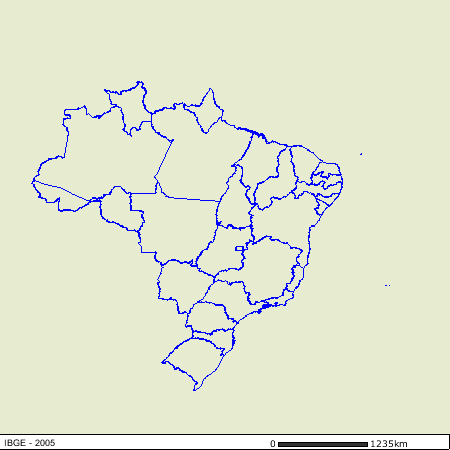
A very simple political map will show the deficiencies:

ae5d8e31.png


This is a modern political map, granted, but the configuration of the states is pretty much the same for the whole of the coastal area and much of the interior. Only the amazon basin saw some big changes from 1836 to today, and parts of the Centro-Oeste (Mato Grosso and Goiás). IMO, since that for most of Brazil there is very little chance of combat happening, we should stick with a political/administrative model for the internal borders, with the exception of the south (triple alliance war) and parts of the border with Paraguay. Now, compare it to this image:

Brazil-Vicky.jpg


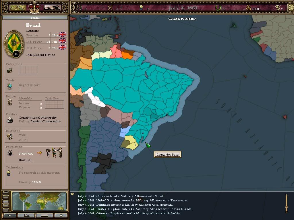
First, the geography is WAY off. The country is "flattened", making it look like it is much bigger in the west-east axis than in the north-south one (when they are about the same). The boundaries with Bolivia and Paraguay are inflated to the south, like it was a "belly" or something. Really wrong. The northern border with the Guyanas, Venezuela and Colombia is also WAY wrong, mainly because the state of Roraima doesn´t seem to exist and that Amapá is very funny-looking. The South border agains Argentina and Uruguay is also wrong, but not that much. The scaterring of states and province also looks almost random to me. The real-life state of Minas Gerais got a state of it´s own in Vicky and it looks almost good, but Bahia is a monstrosity that has no link with it´s real-life part and the rest of the Northeast is a joke. São Paulo looks funny. The South looks actually ok (could be better, of course). The North is made up, but that´s mostly ok, since there wasn´t that much order in there IRL either. It goes without saying that the names are either wrong or misleading. :rolleyes:

Also, answering OHGamer. The fact is that you CAN sail most 19th century warships into the Amazon (up to a certain point, of course). It´s a VERY large and deep river. You could also sail a pretty big ship up the River Plate, and that´s exactly what the brazilian navy did in the War of the Triple Alliance. Brazilian naval power was instrumental in defeating Paraguay (since the only way to resuply the armies was trough the river itself). I don´t see a ingame reason to make the Amazon a navigable (is that a word?) river, but we should really make the Plate and Paraguay river until Assuncion as sea provinces. Really. This would be VERY important to the nations there, given that the biggest war in the Americas after the ACW was the Triple Alliance war and that it involved a lot of sea power, I think it merits an inclusion in the game. One of the most important battles in the war as fought by the navies of the two countries:

http://en.wikipedia.org/wiki/Battle_of_Riachuelo

Ah, as you can see, Paraguay is, theoretically, a land-locked country, but it has a navy composed of modern steamers (a little out-dated by the time, but warships nonetheless). I think this is a big case for a "sea-like" Plate river, up to until the paraguayan border, at least (or until Assuncion, if it´s possible).