• We have updated our Community Code of Conduct. Please read through the new rules for the forum that are an integral part of Paradox Interactive’s User Agreement.
All the provinces are taken up... but I imagine some minor adjustments could be made by OHgamer or Xie??

Well, that is most unfortunate. I don't know if the changes would be possible then. :(

There are many territories which were subject of international diplomatic disputes in South America during the century. Researching about it may be very painful sometimes but there are at least some bunch I can think right now.

- The definition of the 'Cunha Gomes' Line, which divides the State of Amazonas from Acre, at the time bolivian posession. It was fruit of the Treaty of Ayacucho, signed in 1867 by the Bolivian and Brazilian governaments. It gave Brazil a large extension of lands, claimed by brazilian residents in the area.
- The definitive incorporation of Palmas region, disputed between Brazil and Argentina. Under the mediation of President Cleveland of the US, a agreement was reached and the treaty was signed in 1895, thus creating the Treaty of Paris.

Besides that, some borders may not represent the actual territorial disposistion when talking about the Pacific Wars, the Paraguay War and the redefinitions of borders on Amazon.

Too demanding? :(
 
@ThatAwfulPlayer:

I believe that OH and Xie have attempted to include as much accuracy as possible, including almost every land dispute. They may have missed some, but I believe that most are included. However, since I know next to nothing about South American history, I could be wrong.
 
@ThatAwfulPlayer:

I believe that OH and Xie have attempted to include as much accuracy as possible, including almost every land dispute. They may have missed some, but I believe that most are included. However, since I know next to nothing about South American history, I could be wrong.

Considering we had input from a South American player on the province setup for the region (check about 35-40 pages back) I thought we got just about everything covered for the time period to the degree we can given the limited number of tags we had (remember this isn't like an EU3 map with unlimited numbers of provinces, it's hardcoded here in the EU2 engine based games). If we are talking about a disputed territory that's really really small (like the Beagle Island dispute between Chile and Argentina) that is simply not going to be included on the map. As for now, all the tags have been assigned so there is no more that can be added unless we remove provinces from somewhere else (preferably within the nation that will get the new provinces as well).

Acre is in - the province of Taracua is what is today Acre state in Brazil, which represents the land that Bolivia ceded to Brazil via the eventual treaties at the turn of the century. So I'm not sure where the idea that the Acre question is not addressed is coming from.
 
Looking back at Paraguay in the original map for Vicky, it has in the claims that you have on your map too!

Formosa is in, the areas lost to Brazil and Argentina is in, and some area in the west I guess was lost to Bolivia.
 
Looking back at Paraguay in the original map for Vicky, it has in the claims that you have on your map too!

Formosa is in, the areas lost to Brazil and Argentina is in, and some area in the west I guess was lost to Bolivia.
*gained from Bolivia.

For the Patagonian expansion... well we know from maps posted over on Terranova about the control which Argentina and Chilean forces had at certain times. I think that if these changes were made then it would just be a case of redrawing existing province's borders, as opposed to needing more prov tags.

Also, PW, if you wish to know what the id's are download Jamie550's map utility tool and use the map viewer tool. It will tell you what the province is judging by it's colour.
 
There was a part of the Chaco in Paraguay which was given to Bolivia. Incidentally, it was the only part of the Chaco in the two countries where Oil was found. :D The areas are represented by the two most western provinces in 1836 Paraguay.
 
So, I've made a map to make things clearer because only talk talk talk makes it more confusing, and hell it is already confusing enough. My knowledge about South America wasn't very good too before I started researching, since here in Brazil historiography insists to fill up our heads with Europe and Imperial Brazil without talking properly about our neighbors.

I wasn't talking directly about the Acre question. It was in 1903. The chunk of land given to Brazil by the treaty o Ayacucho in 1867 is that one right next to Acre. However it was redefined later and changed by 1903 Treaty of Petrópolis, if I'm not mistaken because of the ambiguity of the text.

Litigious.jpg


To the north, next to Colombia, that piece of land was too a unclear territory. The actual borders were only defined by 1907. Now to Bolivia.

Bolivian territories are rather a adjustment of the borders defined by the current map. The only needed territory would be to represent the cession of Puna de Atacama (Not represented -fixing) to Argentina, in 1889, which was given along with Formosa. Although I suspect in the case of Formosa was more of a cession of claim which was not de facto controlled by the government.

To South Brazil/Corrientes region, it is the more crowded. The purple area on Mato Grosso was disputed by Paraguay and Brazil, but controlled by Paraguay. The piece of Argentinian Corrientes was also posession of Paraguay and both were taken in the Paraguayan War. The Palmas was disputed by Brazil and Argentina and it is that piece missing on the south.

So, I guess it is all. Some of them are just a switch of claims, but it could be made into some events to make South America politics more than just resting away and selling coconuts so rack up money for industrialization.:rolleyes:
 
Great work! This has been a huge undertaking that you've, well, undertaken, but it looks like the results will be fantastic. And now that I've finally caught up, time to make what contribution I can from my little corner of the world (New Zealand kind of obviously).

First off, it's great to see Dunedin in Dunedin, and I won't complain about a 9th province either (and I support your use of 6th biggest city Tauranga over 4th biggest Hamilton for the name - Tauranga's a significant port, and isn't going to double up with other provinces unlike Hamilton). South American players shouldn't grumble too much about distortion in the original map either, not when New Zealand looked like it had had many thousands of years of tectonic plate movements, so this new map is much better.

Secondly, where did you source the province borders? While generally no problems, there are a couple of oddities in the province shapes, which might be justified or might not. Wellington and New Plymouth both seem to jut into Tauranga too much, while Hokitika juts into what should be Dunedin. As a reference, see this picture of NZ's rugby union provinces, which are probably the best way to characterise parts of the country.

The main differences I would make are to move the King country into Tauranga (which would incidentily better reflect the Maori wars), and to put all of Otago in the Dunedin province (there are 3000m of mountains in between the West Coast and Otago, and that bulge of Hokitika into Otago seems to cover the Queenstown area, which historically grew because of the Otago gold rushes). Any other differences between your map and the rugby provinces seem reasonably justifiable. But then for all I know, you're working from a 19th century map of New Zealand and things have changed between then and now more than I'm aware of. It's not like it will impact on gameplay, but the borders do look a little odd. Any questions, just ask.

And don't take any of the negative comments recently too hardly, this kind of thing is bloody hard work, and inevitably involves compromises. New Zealand might be the size of Britain or Japan, with plenty of fish, wood (and arguably tropical wood), fruit, grain, coal, precious metal, and a bit of sulphur, but gameplay and practicalities demand 8/9 provinces of cattle and wool, and I'm fine with that. It is just a game... or at least I try to tell myself that to get myself to sleep :D
 
Here are the original 1841 provinces, while here are the post 1989 provinces, which are based on water catchments and other geographical features for the most part. Personally I'd use the modern borders, merging to align with the 9 provinces in your current map, but it's your project. The number, names and general alignment of the provinces are fine, it's all just cosmetic :)
 
I can see what's happened, you've used the district boundaries, while I've been looking at regions. Some of the districts actually lie in multiple regions. Districts are local government doing most of the administration, and are sometimes based on fairly arbitrary boundaries. The regions are the tier up from districts, and regulate the districts, and look after regional (particularly environmental) issues. Regions reflect natural boundaries and water catchments, whereas districts are often only the way they are because of (relatively modern) historical reasons. I have a very accurate jpeg map of them, but I'm not sure how to put it on here (help on that? if you want the map).

The ones I can tell you for sure: Queenstown Lakes District definitely needs to be shifted from Hokitika to Dunedin, and the Eastern Bay of Plenty District should be part of Tauranga Instead of Napier. Great Barrier Island should be part of Auckland (though that might require a change in the sea provinces), and Kaikoura District should be in Christchurch.

You have the Dunedin/Christchurch border running along what looks like the Waitaki River, when in reality it's only the Regional boundary near the sea. However, it is the District boundary, so it can stay put.

And now for the hard part. If you were to base the Wellington/New Plymouth/Tauranga boundary on the present day Regions, you'd do that by taking Wanganui District and putting it into Wellington, and taking Waipa, Waitomo and Otorahanga Districts and putting them in Tauranga. However, that would have to be balanced against requirements for the Maori Wars in VIP. I think moving the King country districts into Tauranga would better reflect that part of the war (and the rail network for that matter), but that's a personal opinion. Wanganui might be better off being left in New Plymouth, partly for the Maori War events, partly so you don't have to use a name plate. But as I've said, it's your project, they're entirely cosmetic changes, and it is a little late in the piece. And that's still assuming you want to use geographical boundaries over the historical straight line British ones.

Anyway, I'll leave you to it, rather than keep bothering you about a few little lines on a few little islands at the utmost ends of the Earth :D 
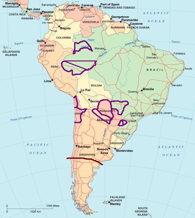
(Though feel free to ask questions)
 
Thanks for that :)


I've colour coded things, and even added pink circles where the ports should go. Hopefully it makes things clearer.