• We have updated our Community Code of Conduct. Please read through the new rules for the forum that are an integral part of Paradox Interactive’s User Agreement.
This thread is a dream come true.

This is one I found during a stream:

Kronstadt should actually be on the isle opposite of St. Petersburg.

map-of-st-petersburg-and-the-surrounding-area-kronstadt-and-the-gulf-CPD19H.jpg

Kronstadt.png


EDIT: This one seems to be fixed, yay! Still a lot to go, it seems, but it's a nice start.
 
Last edited:
  • 3
  • 1Like
Reactions:
I think this is the right thread for this, but sorry if it's not.

The nation Ngāi Tahu should be called Kāi Tahu (in it's language not the northern language) And the leader they currently have, is a Waikato leader. Tūhawaiki or Taiaroa should be the ruler.

Thank you.
 
  • 2
Reactions:
Nijmegen should be South of the Rhine.

Eindhoven should not be the major city for the Southeast ("Gelre"). Use for instance Arnhem, Nijmegen, Den Bosch or Maastricht.

Some representation of Twente (Enschede, Hengelo or Almelo) for the early Dutch industrialisation would be appropriate.
Eindhoven is maybe THE example of village that due industrialisation (Philips,Daf) became a big city in the Netherlands.

Totally agree. It would be great if Maastricht would even be on the map.
only if it’s on the (left) Belgian side of the river Meuse
 
  • 1
Reactions:
Have you stumbled across an area of the world that is not looking as you’d expect it to? For instance, are the borders slightly off, or is it populated by cities that should not exist at the time period of the game? Or do you simply have suggestions for improving the map?

Document them here! We will do our best to investigate it further!

Hi!

I noticed the capital city for the state of Punjab is Multan, I believe this should be Lahore as it was/is a bigger city and was the capital of the Sikh Empire and remains the cultural center of Pakistan today.
 
  • 1
Reactions:
Please add alternate flags for formables ! it is a simple yet powerfull tool to reward players who play minor nations ! having a Saxonian germany flag and tuscan italy for example would be very cool
 
  • 3
Reactions:
There is a significative culture error in the island of Sardinia, reportely inserted as "South Italian", while sardinians literally speak an idiome from a different branch of romance not intelligible with Italian, their culture has nothing to do with peninsular italic peoples and the differences are pretty recognizable.
The game offers cultures like Icelandic, which barely were a thing till 100 years ago, or a whole set of 6 cultures for yugoslavians which literally share same language and customs, yet they forget about sardinians which de facto are a whole parallel universe different than Italians.
 
  • 7
  • 2Like
  • 1Haha
  • 1
Reactions:
Regarding Formosa:

Taitung became significant in a much later era, Tainan should be a better alternative of a historically important city.

Regarding Wallachia:

Slatina became important very late in the 20th century because of its aluminium-industry. Cities like Braila were far more important.
 
  • 1
Reactions:
I've only had 15 mins of game time (so correct me if any of these solve themselves as you play), but I got some minor nitpicks regarding northernmost Sweden:
  • The Scandes should mark the border with Norway, and they should also extend all the way to the Atlantic coast
  • Luleå should be placed on the mouth of the river
  • All the lakes, as well as the entirety of the Skellefte river are missing
  • Luleå seems to be the only city present (Paradox Arctic trying to cover up their existence?).
Beyond that there's also the road. The one going from Luleå to Bodø. I don't know where to start, but it just cracks me up.
  • The road very intentionally crosses the Torne river, despite there not being any major settlements on that bank. Kiruna would be located further south.
  • From there, it quickly goes south, meaning the road-workers would have to cross at least one mountain range. Not even in modern times has this been done.
  • It then crosses the Scandes from Ritsem, Kvikkjokk or Jäckvik. The former two don't have crossings even in modern times, and the one from Jäckvik (which is located so far south it just makes the former point worse) wasn't built until the 1970s.
With all that said, I want to end on a note of potential. Despite it not being realised at the time of the game, I've heard there were road-projects of similar ambition during the period - and it was needed, because it's hard to have a union between two states that aren't connected. Also, in term of cities, I find the development of Haparanda intriguing. Apparently when Finland and Torneå was lost, plans were immediately drawn for a new city to replace it - the city of Karl Johan.

But that's all just potential flavour.

(EDIT) I've now played my first couple of games, not as Sweden though. But Kiruna does indeed spawn in. However, as I said before, not where it should be located.
 
Last edited:
  • 1
Reactions:
Panama Canal:

Let me just repost this here, since unfortunately noone cared when i posted about it back in February....


Considering the graphical fidelity of the game, would it be possible to adjust the model for the panama canal to include the topograhical reality of the region, and have at least Lake Gatun present as a part of landscape and the canal structure? I think that would increase immersion a lot compared to a magical straight canal that the model presents at the moment.

Panama_Canal_Map_EN.png
 
  • 2
  • 1Like
Reactions:
I'm dumping most of the suggestions I can remember about Spain (states, cities, state resources, etc) here. Some of them are already mentioned in this thread, others aren't.

STATES' BORDER CHANGES

-Logroño (La Rioja) should be part of the state of Castile instead of Navarra/Basque Country. Around 147,000 people (roughly the population of this province at the time), and most of them would be Spanish (in terms of game's cultures). It's part of Old Castile in this 1833 regional and provincial map of Spain, showing the much accurate border of the Basque Country and Navarra.

spa1rioja.png


-Murcia should be a separate state. I couldn't find the historical population, but probably would be roughly 1/3 of the game state population, most of them Spanish. Cartagena should also host a naval base, one of the oldest anmd most important naval bases in Spain. See again the 1833 province map showing this state.

spa2murcia.png


-Ceuta, just like Melilla, should be a Spanish city. In reality it would cover a much smaller territory, but probably the best option would be having an artificially big hinterland just like Gibraltar. Population, Spanish with probably a significant Berber or Maghrebi minority.

spa3ceuta.png


-Badajoz state should be renamed as "Extremadura".

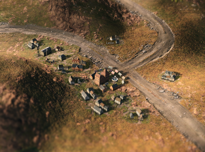
-Besides all of this, consider making Leon another separate state, as it is in the 1833 map. This is not as important as the other suggestions, though.

CITIES

-Leon and Salamanca gfx (mining town and standard city looks) should be switched: Leon was one of the most important mining areas (specially coal) in Spain, while Salamanca wasn't.

spa4leon.png
spa4salamanca.png


-There are some issues with the name and the location of two of the biggest cities in the Canary Islands. Santa Cruz de Tenerife was the main city in the island, and was placed there (see picture), the same about Las Palmas de Gran Canaria.

spa5canarias.png


RESOURCES IN STATES

-Asturias should have some significant coal mines which were exploited since the late 18th and early 19th. On the other hand, Valencia and Navarra shouldn't have the coal deposits they have in the game. It's discussed here.

-The Canary Islands should probably produce bananas. Discussed here.
 
Last edited:
  • 7Like
  • 4
  • 1
Reactions:
Have you stumbled across an area of the world that is not looking as you’d expect it to? For instance, are the borders slightly off, or is it populated by cities that should not exist at the time period of the game? Or do you simply have suggestions for improving the map?

Document them here! We will do our best to investigate it further!
In the Polish version there's a funny translation bug: town of Lissa (north of Silesia) is translated as Leśnica; in fact it should be Leszno. Today Lissa/Leśnica is a neighbourhood of Wrocław, that time a town on its own.

Bielsko is actually where Biala (or Beil, as it was then) should be. Bielsko is in Silesia, while Biala in Lesser Poland (https://pl.wikipedia.org/wiki/Biała_(Bielsko-Biała)#/media/Plik:Map_of_Bielitz_1855_(2).jpg)

Czech town or Breclav should be more southe, closer to Vienna and Pressburg. Even today it is an important transport hub.

Slovak Kosice should be a bit closer to Miskolc, while Poprad further north (and in the mountains). Poprad however until 1870s was a tiny village, more important town in the region was (and still is) Presov. And that part of the land misses A LOT of mountains.

BTW - where should we report translation errors?
 
Last edited:
Bytown (Ottawa) wasn't incorporated as a town until 1850. It was never the capital of Upper Canada, that was Toronto. Kingston is also missing from the map, which is odd considering it was the original capital of province of Canada
 
  • 2
  • 1Like
Reactions:
State borders should be changed so that the Rhine can be a border between countries. While obviously not being one during the period of the game, the Rhine was nonetheless a border that French Jingoists wanted to reclaim after having it for 20 years from 1794-1814, and it being seen as 'France's natural borders' by many. The Rhine Crisis of 1840 is an obvious example of this historically, and currently the distribution of provinces into states does not seem to allow for this border.
 
  • 14Like
  • 2
Reactions:
Montreal should be on an island.

It became a center of commerce and an industrial power for this reason, because the Lachine canal was built inland, on the south bank of the island, in order to bypass the Lachine Rapids and make it possible to open the western part of the river to commerce. The canal was quickly surrounded by an industrial district.

Also, it is true that the river narrows past Québec, but not so drastically. The port of Montreal is still a major port in eastern Canada and heavy ships are able to make it there.

The whole topography of Lower Canada is also a bit off. The Laurentian mountains do not border the St-Lawrence river on the north. A lot of arable lands are located in the St-Lawrence valley in between the fluvial way and the mountains.
 
  • 3Like
  • 2
Reactions: