• We have updated our Community Code of Conduct. Please read through the new rules for the forum that are an integral part of Paradox Interactive’s User Agreement.
Since the game starts in 1836, it's ok that Lucca is not part of Tuscany.
I think @Sparasax is referring to the fact that it is seemingly arbitrarily part of Emilia. Pretty much all of Lucca's history from the middle ages ties it more closely to Tuscany than anywhere else to the point the decision to place it in Emilia simply makes no sense. The only thing I can see connecting it to Emilia is that the Duke of Lucca (who was former King of Etruria/Tuscany!!!) from the house Bourbon-Parma had a claim to Parma and was granted the Duchy of Parma and Piacenza in 1847. Though I will say that Lucca's description on the country selection screen makes it seem like reclaiming Parma is what an early goal of the playthrough would be if you were to play as Lucca. It's possible the intention could be a path of expansion to consolidate power as one of the small states in the region. However, Lucca doesn't actually start with a claim against Parma so kind of mixed signals. Could also just be so that Emilia can have a coast.
 
Last edited:
Anhalt's got the most productive soil in all of germany, there's waaaay too little arable land there.
Southern manchuria still has a natural harbor despite being landlocked
 
Insanely minor detail, but Delaware should start with a chemical plant or Arms industry at least. Delawarean gunpowder production was one of the biggest sources for the US civil war and had already been going by the 1820s.
 
  • 2Like
Reactions:
she's an island boys

vancouver island.png
 
Not sure if this counts, but Plymouth was never a major city in Massachusetts. Would be more appropriate to switch it with New Bedford or Fall River for their connections to whaling and textiles (plus Fredrick Douglas and Lizzie Borden respectively) to the south west or go north west of Boston for Lowell as it is the most famous mill town from that era.
 
Hey! This is not an attempt to argue or anything, but since you brought up many good points i'd like to discuss them to present a good picture of the situation on the Argentine Confederation at the time and how can be improved on the game.


-I'd say the slavery/segregation is acurate in game. Slavery was not abolished on 1813, the 1813 assambley only stablished freedom of womb (new born people of slaves were free) but people already slaves remained slaves, and they did so in great quantity. It is exactly what the "slavery legacy" law describes. Slavery was abolished fully only in 1853.

-And there *was* at least some degree of legal segregation, school was different for black people, and for example, universities didn't acept black people until 1853. Considering that the law about ethnicity in the game is a bit abstract to represent a general sense of state discrimination or not, I think is okay as it is, with afro-caribeño people still becoming easily non-discriminated with a bit of law relaxation since they share the hispanic speaking trait.

quick sources to check on this https://en.wikipedia.org/wiki/Afro-Argentines https://es.wikipedia.org/wiki/Afroargentino https://es.wikipedia.org/wiki/Asamblea_del_Año_XIII

-I'd be careful about modern narratives about how cruel or not cruel Rosas was, but independiently of that, i think the local police law is accurate. The mazorca was sort of a para-military group, perhaps comparable to like, the klu klux klan, which i'm not sure is represented on the game.. Nevertheless, what argentina did had were "jueces de paz" along "alcaldes" (https://en.wikipedia.org/wiki/Justice_of_the_peace https://es.wikipedia.org/wiki/Justicia_de_Paz_(Buenos_Aires)) which in our local colonial and post-colonial region were basically sheriffs and align with having the "local police force" law.

>Fully agree on the provinces. Though i'll leave that for the last to go to the specific cases.

>Like with rosas, i'd be weary of today political narratives/manipulation about this topics. The historical consensus by academics, is that that native americans people across both sides of the Andes had complex relations withouth a clear border, and by the time of the game (and even later) most of the people of what today is argentinean patagonia were "mapucheized" speaking mapuche lenguage and having mapuche culture. Considering the game has inevitably to do some degree of consolidation, and already represents any of the native american as single nations instead of collectives of peoples (hence the descentralized nature) i personally think is okay to represent it this way, and the fact that there are different states is enough to represent colonization by chile or argentina by different sides.

some sources https://en.wikipedia.org/wiki/Tehuelche_people https://en.wikipedia.org/wiki/Araucanization_of_Patagonia

(I would say, I am a history student, if i'm sourcing wikipedia is just cause is the simplest/safest/quickest thing for people/devs to check on this on english that i know of, but there's plently of spanish history books backing up this stuff)

>I'm split on the Tierra del Fuego stuff (pun unintended). Is true that the game is historical but is a historical simulation about "what could happen". In practice the patagonia was an open land that both Chile and Argentina had vague undefined claims to, and the current border we have today is just a happen of particular circunstances. It could very well be the case that Chile expanded more than it did historicaly or that Argentina did so, and the game allows to respresent that..idk, i'd be more happier if like, in some vic 2 mods,the island remains undivided, but there was an event or decision to "define the border" that let you split the state, accurately representing negotiations between the two states to define their borders.

Fully agree on the much more political situation but i hope a DLC/Patch will work that, and is more than what this thread is asking for.


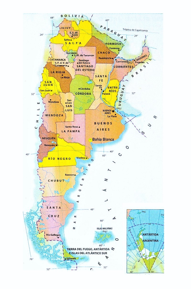
So on that regard, map:

I'm aware there are many cities that don't appear at start but would appear as the provinces are more developed. This is a shame and product of the huge states ont he region, but at the very least, i think the priority of which ones appear at start should be given to the biggest cities, which can be clued cause they are often the ones that share the name of the state.

So, the state of Mendoza (still called Rio Negro on the files) is missing the city of Mendoza at start, founded in 1561-62. It was literally the biggest city of the region, being the capital of the whole "cuyo" regiun that includes the also provinces of San Juan, La Rioja and Catamarca https://en.wikipedia.org/wiki/Mendoza,_Argentina
On the files, the city of San Juan is marked as in the state of Mendoza, but should be on the state of Tucuman. https://en.wikipedia.org/wiki/San_Juan,_Argentina

The state of Tucuman includes the city of La Rioja, but Tucuman (the city) should be the first to appear.

Santiago del Estero and not Resistencia should also be the first city to appear on the state of Chaco, as Santiago del Estero is an old colonial city that appears on the already colonized area at start, while Resistencia is founded in 1860: https://en.wikipedia.org/wiki/Santiago_del_Estero vs https://en.wikipedia.org/wiki/Resistencia,_Chaco

The state of Santa Fé should really include the city of Paraná, over zarate or Rafaela. Paraná was not only the probably third most important city of the country, it was literally the capital fo the Argentine Confederation for several years while Buenos Aires seceeded into it's own state. https://en.wikipedia.org/wiki/Paraná,_Entre_Ríos

About the Province of Buenos Aires, i'd like to make a special case, Mar Del Plata, the assigned fort, didn't exist until 1870, and while it will become an important beach resort, is quite a late addition. On the other hand... you have the city of Carmen de Patagones, founded in 1779, as an isolated fort on the south of the province of buenos aires, deep on native american territory, it was connected to the capital only through it's port. It was also Argentina's main naval base during the war against brazil.

Adding a single colonized province to the area and adding the port-city of Carmen of Patagones would be a great addition imo, both to the historical accuracy and also would just look cool as an outpost/frontline to defend https://en.wikipedia.org/wiki/Carmen_de_Patagones

This is, for the states already existing. I do have to say that, the lack of states is a shame. I would like to make a case for more states partition not just for the case of that they are huge and inacurate, but because having more states will probably help gameplay in argentina, a country that in the time period of the game went from the middle of nowhere to be the 8th largest GDP in the world with higher GDP per capita than Australia or Canada. It was the golden age of Argentina, and also a complex interested period marked by civil wars, confederations, revolutions, revolts, etc. And having more states would be really helpful to represent that.
At the very least, spliting the state of Santa Fe and Entre Rios, Cordoba and San Luis and creating and splitting the state of tucuman in half (Tucuman and Catamarca in one side, San Juan and La Rioja on the other) could be a minimum compromise, to at least have some of the most important Provinces or argentina be on their own.

Finding extra city names for this state could be easy and i'd assure you any fan of the region would care much more about the states more accurately being split than the super acuracy of the population distribution.

PS: adding some maps to help with what i'm saying

this is someone's artistical represention of the Argentien Confederation on 1836: View attachment 899543https://www.deviantart.com/cornycator/art/The-Argentine-Confederacy-In-1836-889138486

this wikipedia map of the vicerroy show which cities were already important several decades before the game startView attachment 899544 https://en.wikipedia.org/wiki/Argen...o_mapa_del_virreinato_del_rio_de_la_plata.PNG
Would like to add a bit more to Argentina. The Patagonia should be able to discover Oil. Oil was discovered in the area in 1907, with rich enough reserves that in 1922 YPF the first fully state-owned oil company was created, which as an important piooner industry on the world. https://en.wikipedia.org/wiki/YPF#History
Whaling was also big on both the Patagonia and the Araucania, and while I bring a source here, i think it honestly should be pretty intuitive for literally the same reason than whaling is big in all those cold places close to the artic. https://en.wikipedia.org/wiki/Whaling_in_Argentina

Also, for the same reasons said before, that Mendoza is one of the oldest and most important cities of the Argentine Confederation at the time, the state should start incorporated, there really is not reason why it shouldn't. I did forgot to mention last time, that while the existence of the city of San Juan is good, right now is on a wrong province, located inside the State of Mendoza, when it should be slighty norther, on the state of Tucuman, which includes the province fo San Juan named like that for the same city.

provincias-y-capitales-de-argentina.jpg

The state of Cordoba should probably also have the pampas agriculture trait, considering it's eastward part is still one of the most productive and agriculture focused of the country (this would be easier if the province of San Luis was separated from the state).
So should the land that corresponds to the province of La Pampa... literally called like the trait. It could be easier if the province was it's own state or if it was fused with the State of Buenos Aires, which shares more similarities with it (agriculture fertile grasslands) than with the State of mendoza (hilly/mountaineous vineyard region).

I do admit that I find a bit unfair/unfounded that both the agriculture bonus on unkraine and argentina are of only a 15% (the same than the Scania region for example) while the one in the Midwest is of a 20%. While the US (and other countries)were/are larger producers of grains than Argentina, what characterized the country is precissely the huge productivitydespite it's smaller size and population. Is harder to find much data on this, but for example, enough is to look at modern values of productivity per worker.
unknown.png
unknown (1).png


It is fair to point also, that this probably should also include a bonus to livestock (if it isn't already), which was the main production of the country up to the second half of the XIX century.

The whole states of Chaco and Alto Paraguay should have a trait for wood explotation or wood thorough, representing the highly priced and valued Quebracho wood (of which the chemical Tannin can be extracted), which lead to the massive explotation of the area, and was the main reasons british companies build railways and colonized the area. Specially by the existence of La Forestal, world's first producer of tannin and one of the largest and most powerful companies of the time https://es.wikipedia.org/wiki/La_Forestal (article in spanish but easily translated)

There is something a bit weird about the infraestructure traits as well, the state of Corrientes has two traits for it (Paraguay and Parana), Santa Fe one (Parana), and Buenos Aires none. This ends up working backwards of how it is in real life, where Santa Fe had a considerable fluvial transport development, and Buenos Aires was the most of all. I'd suggest adding the Uruguay trait (already existing) to the state of Santa Fe, and adding the Parana one to the state of Buenos aires, along with another one for the Rio de la Plata. Controlling the Rio de la Plata, the natural end of all the fluvial infraestructure of the region was the key element that made Buenos Aires so strategicaly important and why our civil wars were fought over the Custom House applying taxes to products entering or leaving through that bottleneck. https://en.wikipedia.org/wiki/Buenos_Aires_Customs
(with enphasis on this paragraph:
> The building reflected the importance of customs duties to the national treasury itself, which from the colonial era of the Viceroyalty of the Río de la Plata until 1930, accounted for around 80 percent of government revenues.

Though honestly, more traits all around would be good to reflect terrains like the cold patagonian steppe (less good for agriculture but great source of livestock) or the vineyards of Mendoza or the hard to live hot swarms of the Chaco. Though I feel that's something that applies to the whole world, honestly.

Lastly there should be a representation of the Universities of Cordoba and the University of Buenos Aires, old universities working since 1613 https://en.wikipedia.org/wiki/National_University_of_Córdoba and 1821 https://en.wikipedia.org/wiki/University_of_Buenos_Aires
 
  • 1
Reactions:
There is no bridge over Volga from Samara to Samara luka in real life. One has to travel to Tollyati(it was Stavropol in the game timeframe, also the old place was flooded by the dam) or Saratov. Also there is no city on the Luka, only villages.
 
A minor correction: Tananarive in Madagascar should be called "Antananarivo;" Tananarive is the French version of the name while Antananarivo is the Malagasy version that the Merina would have used. Likewise with Tamatave => Toamasina and Majunga =>Mahajanga.
 
Last edited:
In Crete (today's Greece) you have the names of the cities wrong. Chania is to the west and Irakleion to the east. Also I really doubt Matala was, or could ever be, anything bigger than a fishing village (and later Hippie paradise!! :p) . Rethymno is and was the third most important city and if you want something in the south, maybe Ierapetra in the southwest would be a better choice.
 
  • 3Like
Reactions:
NAME CHANGE PROVINCE IN THE NETHERLANDS

please change the name of the state GELRE to GELDERLAND. The historical medieval duchy name GELRE was replaced with GELDERLAND in 1795 with the new département provincial administration that was enacted during the French occupation of the Low Countries.
 
  • 1Like
Reactions:
I have some proposals and the sources for changes to New England and New York. Please bear with me and my MS paint skills. Thank you for creating this great game and I appreciate all the hard work you do! If we could mod the map I would do it myself!

Red - Mountains
Purple or Orange - Hills
Yellow - State Borders
Green - Land
Blue - Bodys of water

1. New England
View attachment 899274
1. The mountains are way too high. There are not nearly this many bald face mountains in New England. They should be small hills starting in Mass and Connecticut and then get bigger in Vermont and New Hampshire all the way to Maine. There are only two big mountains here that I could justify being that large, Mt Washington, and Katahdin in Maine.
2. Connecticut does not have it's tip into New York and no notch bordering Mass.
3. Rhode Island has way too much of Connecitcut, and is missing the Island that gave it it's name. That Island holds Newport. The entire bay region I had to redraw.
4. In Massachusetts the Fall River New Bedford area has lost all its' land. The land here should extend closer to Marthas Vineyard as shown.
5. I will say that I am impressed that you all added Block Island and Martha's Vineyard. Good attention to detail but PLEASE add Aquidneck Island since that is how Rhode Island got its name.

Source:
View attachment 899284

2. New York
View attachment 899286
1. New York is missing the entire mountain range that extends into Pennslyvania along the border with said state. Hills should be extending from those Mountains a bit as shown in the image above.
2. The mountain ranges are far too high here. Mountains should really big large hills here.
3. New York is also missing The finger lakes which I have drawn in blue above.
4. The border with Canada needs to be reworked and Niagara Falls are missing here!? Add the river please!
5. The borders are outlined in gold and need to be reworked along Connecticut and Pennslyvania

Source:
View attachment 899288
Not to disagree too hard with this and other (good) posts on how the Appalachians look, I do want to stress they are still mountains. Many of them have alpine climates, and posed major barriers to travel and commerce at the time (and in some stretches, even today).
 
  • 2
  • 1Like
Reactions:
Don't know if it's going to be handled via journal entry or something at some point but atm, it's impossible to form Romania without having more land than Romania actually had when it was declared in real life.

The most similar to IRL borders you can form it with still require you to annex all of Dobruja, Romania wouldn't get the northern part of until 1878 and the southern part of until 1913. As well as Bucovina (as it is a part of the state of Moldavia) which Romania wouldn't capture irl until 1918.

Keep in mind a Romanian state predates the declaration of the Kingdom, as both Wallachia and Moldavia had been in de-facto union under one prince since the 1850s, so at minimum you need to get a few pieces of land 60-70 years early to form Romania at all. In game terms this Principality of Romania, the "Old Kingdom" would only have two states, with one being the split Moldavia. Even when the real Kingdom of Romania was declared, in game terms it would only have had 1 complete state and two split states.
 
  • 2Like
Reactions:
A serious error regarding Uruguay: It is extremely easy to conquer Uruguay at the beginning of the game with Brazil or Argentina. The truth is that in real history, Uruguay had the protection of the United Kingdom, thanks to which the independence and consolidation of the country is done. In the game Uruguay should start with an agreement with the UK to guarantees their independence in the early game.

On the other hand, the Uruguayan headquarters is called "Brazilian headquarters" (at least in the Spanish version). It should be "Montevideo headquarters.".
 
  • 1
  • 1Like
Reactions:
A serious error regarding Uruguay: It is extremely easy to conquer Uruguay at the beginning of the game with Brazil or Argentina. The truth is that in real history, Uruguay had the protection of the United Kingdom, thanks to which the independence and consolidation of the country is done. In the game Uruguay should start with an agreement with the UK to guarantees their independence in the early game.

On the other hand, the Uruguayan headquarters is called "Brazilian headquarters" (at least in the Spanish version). It should be "Montevideo headquarters.".
The HQ always have the name of the overall strategic region, and Urugay is included in Brazil's.
 
Firstly this is my favourite Paradox Game Ever, I can't stop playing.

Now my report, I noticed some small issues in South Africa:

1. PLEASE Change DA AAR in the Northern Cape to DE AAR it's definitely a typo.

2. Johannesburg (The biggest city in Southern Africa that boomed during the gold rush) barely grows at all throughout the game with all the urbanization going to Pretoria. I would love to see gold mines and the gold rush contribute to turning Johannesburg into the metropolis it exploded into during the victorian era.

3. Margate in Zululand is actually SOUTH of Durban not NORTH. The town now labelled as Margate should probably be Richards Bay based on its location (itself an important port in South Africa)

Hope this small contribution helps.
 
  • 1Like
Reactions:
- Cities of Toulouse and Montauban (France)are misplaced, and should be placed on the river "Garonne", and not far at the east of it. But apparently, misplaced cities are a common thing on this map...
- There are a lot of big lakes in the south island of New Zealand. Where are they?
- Addition of the volcano Vesuvio (normally near to Napoli). It's essential.
 
Last edited:
In 1836 Cincinnati should be the primary city in Ohio. It was by far the largest city in the state. In the 1940 census it was the 6th largest city in the US and ~4.5x largest than the next largest city in Ohio, Cleveland.

Which then brings up Toledo and Athens. Why Toledo for a farm city or Athens for resources? Toledo in the 1840 census totaled just 1.2k people, vs Cleveland and Dayton with ~6k and Zanesville which had ~4.5k. Toledo wasn't even a part of the 1830 census. Athens didn't even have 1k in 1830, and didn't cross that threshold until 1860.

For a resource city in Appalachian Ohio, Steubenville on the Ohio River makes much more sense. in 1840 in had over 4k people and was one of the 100 largest cities in the US. For farming, Toledo isn't a terrible choice considering its growth during the century, but I would choose Columbus instead.
 
There was a major gold mine in Taiwan discovered in 1890. An estimated 120 tons of gold, 250 tons of silver, and 250,000 tons of copper were extracted before its closure in 1987