We have updated our Community Code of Conduct. Please read through the new rules for the forum that are an integral part of Paradox Interactive’s User Agreement.
You are using an out of date browser. It may not display this or other websites correctly. You should upgrade or use an alternative browser.
The purpose of this thread is to compile my own suggestions for how to improve France (a nation currently portrayed anachronistically as being a homogeneous blob) in the hope that some of these ideas may find their way into the game.
To start, I am going to say that this is in no way a buff or a nerf to France, but rather an overhaul. The main challenge I have faced in compiling these suggestions, and the biggest question for whoever at Paradox reads this to consider: How do we make France more interesting, immersive and historically accurate, but also bring plenty of challenges at the same time?
With that question in mind, I’ll go through a comprehensive list of the changes that I am proposing in posts throughout this thread, complete with my reasoning for each change.
NB:Everything I post in this thread may be subject to change when necessary.
Since it was pointed out above that Évreux was in fact a French possession, I've been looking at the status of other cities in the area and found, surprisingly, that even a major coastal city was in French hands in Nov 1444: Dieppe was recaptured on Oct 28, 1435 by Charles Desmarets and was held by France ever after.
I don't think Dieppe itself warrants inclusion as a province. Castles in Normandy and Gascony continually switched sides before 1444 and even after that (until the end of English occupation of France in 1453). Same with towns in the modern Landes departement; many switched sides and some were even under joint control. So, I don't think anything has to change in the English Aquitaine region, as it would create a patchwork of small provinces. Normandy looks fine, too, but could maybe use some adjusted borders to make sure that Evreux is in the in-game province of Chartres.
I agree with Neondt that Northern France looks quite good already. I only suggest to him to look at some borders and names:
- Caux; the city of Rouen isn't even located in the Pays de Caux. Rouen would be a better name.
- Armor; a division made after the French Revolution; not a Breton name.
- Finistere; a division made after the French Revolution, also not a Breton name.
I wouldn't mind another province for Brittany, either. But that's up to the devs.
I don't think Dieppe itself warrants inclusion as a province. Castles in Normandy and Gascony continually switched sides before 1444 and even after that (until the end of English occupation of France in 1453).
I think the solution that was elected is to set english cores on lands that were sometimes switching sides. I think it's an elegant solution, and it can be followed for new additions as well.
I agree with the premise, not with the conclusion. Would a patchwork of some province be desirable? Two patches ago I'd have to say no, but currently it's under investigation how to rework Italy, and things look like they would be given many provinces. A way to balance this would be to add some to France as well; bear in mind iberia was detailed more in last patch and GB when RB came out so it's not like that level of detail would be unprecedented.
This one however is indeed french like, roughly meaning "end of lands". I do agree with the comment that it would be neat to have some emphasis on Breton as a culture. It has kept its language almost intact up to these days, names (first names and surnames alike) are easy to find, even toponyms have been translated in present day.
Also, they share ties with celtic cultures in Wales and Ireland, so they have an argument belonging to either culture groups maybe more than French… but then again I think it's nitpicking in the coarse framework that is eu4
I agree with Neondt that Northern France looks quite good already. I only suggest to him to look at some borders and names:
- Caux; the city of Rouen isn't even located in the Pays de Caux. Rouen would be a better name.
- Armor; a division made after the French Revolution; not a Breton name.
- Finistere; a division made after the French Revolution, also not a Breton name.
Not to mention "Aquitaine" which is the name given to the province with Bordeaux in game, but actually covered a much larger area. It was called Bordeaux previously (which was a lot more accurate, even if it could have had a better name than that). That name change should be a definite if southern France is ever revisited.
I agree with Neondt that Northern France looks quite good already. I only suggest to him to look at some borders and names:
- Caux; the city of Rouen isn't even located in the Pays de Caux. Rouen would be a better name.
- Armor; a division made after the French Revolution; not a Breton name.
- Finistere; a division made after the French Revolution, also not a Breton name.
I wouldn't mind another province for Brittany, either. But that's up to the devs.
Things like this can (and likely will be) revised.
On the topic of Brittany, I don't feel inclined to add more provinces because it would mean breaking up the area/state; 5 provinces is the most we allow per area, and adding more would force us to make arbitrary and ugly areas that would damage Brittany's in-game cohesion.
Reader of this forum even if i'm not a great contributor, I might have some suggestions to make regarding trade goods in southern parts of France.
I think the provinces of Toulouse and perhaps Carcassonne should produce dyes. In 1444 Toulouse starts as a poor city, but experiencing a fast development of the blue pastel trade. In fact, 15th and 16th centuries will be a golden age for the city. Toulouse merchants have embellished the city and were so rich that only one of them (Jean de Bernuy) in 1525 was enough to pay the ransom requested by Charles V after the defeat of Pavia where the king François the Ist was made a prisoner. Commercially, at this time, Erfurt/Thuringia and Toulouse are twin cities.
Pastel (also called "cocagne" there) was brought from the surrounding countryside by road for the south-east Carcassonne and Languedoc areas, or through the Tarn river for the north-east Lauragais and Albigeois regions (still known as the "Cocagne Country" nowadays). Then it was bought by merchants, loaded on barges on the Garonne river, send to Bordeaux, and transported by boats to be sold in spanish, english and dutch harbours.
The decline begins with the etablishment of trade compagnies in India and the indigo trade. A century and a half of trade that will totally facelift this region, and which is still visible nowadays. I live there, despites the city itself is called the "the pink city", pastel blue and merchant hostels are everywhere, here and in the countryside.
Then, there is the Lyonnais province, actually producing paper. I'm okay with this, but only as a start trade good in 1444. In the middle of the 16th century, a silk production begins to develop, supported by the king itself. It will soon collapse because of religion wars. But soon after it restarts, stronger, again helped by the royal court. The Lyon factory became the main royal provider for silk. Until there, the french silk production just follows the italian one, but under Louis XV and Louis XVI it will follows his own way and succeed. Lyon gets "the fair reputation of the metropolis of silk", main producer in europe and internationally recognized, as Paris became simultaneously the european capital of fashion. Bad days for italians...
I think France needs an additional mission tree, focused on trade just like the one that gives silk to Aragon.
Even if that disregards entirely the piece of historical evidence above?
I think the solution that was elected is to set english cores on lands that were sometimes switching sides. I think it's an elegant solution, and it can be followed for new additions as well.
I agree with the premise, not with the conclusion. Would a patchwork of some province be desirable? Two patches ago I'd have to say no, but currently it's under investigation how to rework Italy, and things look like they would be given many provinces. A way to balance this would be to add some to France as well; bear in mind iberia was detailed more in last patch and GB when RB came out so it's not like that level of detail would be unprecedented.
This one however is indeed french like, roughly meaning "end of lands". I do agree with the comment that it would be neat to have some emphasis on Breton as a culture. It has kept its language almost intact up to these days, names (first names and surnames alike) are easy to find, even toponyms have been translated in present day.
Also, they share ties with celtic cultures in Wales and Ireland, so they have an argument belonging to either culture groups maybe more than French… but then again I think it's nitpicking in the coarse framework that is eu4
There are a lot of places in EU4 that can't be modelled correctly because the province would be too small. I see no way to include a Dieppe province between Picardy and Caux (Rouen). A core on the provinces there should suffice. We don't even know how much of the area surrounding Dieppe was under actual French control/occupation.
About undesirable patchworks; they're needed sometimes, but we're talking small towns and fortresses here; not cities the likes of Italy has. The situation is quite complex in Aquitaine; some towns are loyal to the English, some are occupied by the French and others are under joint rule. We can't reflect that in EU4. An Albret province could be added, but as I said earlier; it's not very populated, it's forested and the only thing of note is the castle of Tartas and the towns/villages of Albret and Mont de Marsan. The core on Aquitaine serves this purpose very well, as this region was quite dynamic on itself.
Anyway, how would you handle this region?
About the Breton province-names I mentioned; you're definetely right about Armor being a Breton name. The problem is that it isn't historical; Armor was created after the Revolution. It should be named after the Breton cities located there, or after the correct county. My signature has some more explanation on this matter.
@neondt I'm not sure what makes a word more civil than another in english, but whatever. If you only need reasons to add a province I think I have enough to give you on this subject.
I won't repeat the territorial differencies (because, it would be redundant with all these threads years after years) and elaborate about a more economical point of view, which is usually not the main argument.
Caux, on the other hand, is a big region toward the sea, without a clear main town (Dieppe being preeminent for EUIV timeframe, and le Havre beiing the late bloomer, while Fecamp was always of lesser importance, but still a main town in the area).
Le Havre, is one of the youngest town in France, founded by king Francis the first in 1517, and strenghtened by cardinal Richelieu in the early XVII century. It became one of the most important harbor for trade, and specifically the slave trade (big ships couldn't enter the Seine river to Rouen)
(see the pdf on Rouen above) https://www.lehavre.fr/ma-ville/une-ville-chargee-dhistoire
Well, all of this to argue that Caux and Rouen shouldn't be the same province. Caux beiing every time of its history focused on the sea; while Rouen was always a major place for trade and adminsitration. (If possible, a centre of trade on the new Rouen province would be accurate)
Thanks for reading, I hope this is the kind of motifs you want. I don't really see what "gameplay reasons" would be is it about potential events? There are a lot to say here, as le Havre by itself is not existing in 1444; and the coton plantations in the early XVIII century were a big help with the growing business competition against british and dutch manufacturers.
Well, all of this to argue that Caux and Rouen shouldn't be the same province. Caux beiing every time of its history focused on the sea; while Rouen was always a major place for trade and adminsitration. (If possible, a centre of trade on the new Rouen province would be accurate)
Caux could just be renamed to Rouen (being the much more important city as you rightly said), as there's no way you'd fit Rouen AND Caux on the map with Evreux as well.
The more I dig up materials about Breton divisions the more I agree with the current map design.
If I understand correctly, the idea is to put together Léon (named already used in Spain) - Trégor and Cornouaille (contrarily to what I said, it's without "s") as a single entity which is close but not quite exactly the same as present day Finistère (in fact it had a name, it is called "Trois Evêchés" - "Three Bishoprics" - but that name is already used in Lorraine so that won't work). That's what the ingame map is, and that makes a lot of sense. Now, calling it Cornouaille (or even with a Breton name? idk) would be better, I agree there, but the map division is perfect.
Vannetais is also great, together with the Léon Trégor Cornouaille they formed lower britanny, where breton culture remains strong up till nowadays. Its boundaries are also close to Morbihan, so there is the question to replace the name with the more modern one.
For Finistère/Cornouaille, it makes sense for Quimper (Kemper in Breton) to be the capital city of the province, Brest gaining importance *as a port* and *much later on in the game* (under Richelieu, mid 18th). Also digging into this article, Quimper faience started being a thing starting 1708, which is rather late into the game. Until then it could be producing Naval Supplies (it's a celebrated place of naval craftsmanship), and we could have a
"Since 1708, Quimper faience has been painted by hand, and production continues to this day. The "Faïenceries de Quimper" were established in "Locmaria", the historical faience quarter of the city of Quimper, near the center." => quoted from wiki
Triggers allowed if:
- is Brittany OR is France
- year is >= 1700
MTTH: 120 months (10 years)
Outcome:
> Excellent. (+5 prestige, Chinaware is now produced in Finistère/Cornouaille).
If I understand correctly, the idea is to put together Léon (named already used in Spain) - Trégor and Cornouaille (contrarily to what I said, it's without "s") as a single entity which is close but not quite exactly the same as present day Finistère (in fact it had a name, it is called "Trois Evêchés" - "Three Bishoprics" - but that name is already used in Lorraine so that won't work). That's what the ingame map is, and that makes a lot of sense. Now, calling it Cornouaille (or even with a Breton name? idk) would be better, I agree there, but the map division is perfect.
Vannetais is also great, together with the Léon Trégor Cornouaille they formed Morbihan, another Breton name) starts with good dev/trade, it was a roman city that was quite thriving, and also a significant port in the colonial era (admittedly less so than Bordeaux though.)
Then the idea is to pack together Saint Brieuc, Pay de Dol and Saint Malo and it makes sense. It looks really nice.
TL; DR: there might be an argument that you'd want to rename Finistère into Cornouaille if you favour old toponyms, or if you favour later toponyms you'd want to rename Vannetais into Morbihan.
Specifically onto Finistère/Cornouaille, it would make sense for Quimper (Kemper in Breton) to be the capital city of the province, Brest gaining importance *as a port* and *much later on in the game* (under Richelieu, mid 18th). Also digging into this article, Quimper faience started being a thing starting 1708, which is rather late into the game. Until then it could be producing Naval Supplies (it's a celebrated place of naval craftsmanship), and we could have a
"Since 1708, Quimper faience has been painted by hand, and production continues to this day. The "Faïenceries de Quimper" were established in "Locmaria", the historical faience quarter of the city of Quimper, near the center." => quoted from wiki
Triggers allowed if:
- is Brittany OR is France
- year is >= 1700
MTTH: 120 months (10 years)
Outcome:
> Excellent. (+5 prestige, Chinaware is now produced in Finistère/Cornouaille).
The old names were used for the vast majority of the timeline, so it's a no-brainer.
The departements of France were designed by the revolutionaries so that every settlement would be within a day's march of its capital in order to control the country. They were also very carefully named, usually after the main river in that department so that those who saw themselves as Poitevin, Gascon, Breton, etc. couldn't associate with them. So why should the game use the same nomenclature for a game taking place mostly before then?
Something done in ten minutes based on the different baillages of the Généralité of Rouen (Baillage of Caux, for Caux; Baillage of Rouen and Baillage of Chaumont in Vexin for Rouen; Baillage of Evreux and diocese of Evreux for Evreux):
if you give me thirty minutes, I can do something much more aesthetic, and as you can see thoses provinces are in the same size as the province of Armor in Brittany.
edit: Version 2.0 (I stop before redrawing all of Normandy, the western part seems too big, but I'm not sure it's the time without having cleared this big Caux province before):
nb: after redrawing it, I feel like I was too harsh with your cutting of Evreux in my first post, sorry.
The old names were used for the vast majority of the timeline, so it's a no-brainer.
The departements of France were designed by the revolutionaries so that every settlement would be within a day's march of its capital in order to control the country. They were also very carefully named, usually after the main river in that department so that those who saw themselves as Poitevin, Gascon, Breton, etc. couldn't associate with them. So why should the game use the same nomenclature for a game taking place mostly before then?
Something done in ten minutes based on the different baillages of the Généralité of Rouen (Baillage of Caux, for Caux; Baillage of Rouen and Baillage of Chaumont in Vexin for Rouen; Baillage of Evreux and diocese of Evreux for Evreux): View attachment 432983
if you give me thirty minutes, I can do something much more aesthetic, and as you can see thoses provinces are in the same size as the province of Armor in Brittany.
edit: Version 2.0 (I stop before redrawing all of Normandy, the western part seems too big, but I'm not sure it's the time without having cleared this big Caux province before): View attachment 432997
nb: after redrawing it, I feel like I was too harsh with your cutting of Evreux in my first post, sorry.
It's a doable task, but you can see how the detail in the map is distorted as a result of that. That's why I feel that only two of the three would make it in at most. Anything else is just overdoing it, in my opinion.
In Northern France, I would make one more change: splitting up the Luxembourg province along the borders of today.
Not only would that create a normal and a low development province instead of a large development one, it would also open up quite a few tactical choices in this inevitable border region.
I didn’t originally intend to create this part of the suggestion, however I found that it was necessary in order to clear up some technicalities with the map, such as where forts would go and what terrain type each new province would have.
The previous part is being subject to updates over the coming days; as with all suggestion threads the input of other users has been invaluable in helping with the thread’s construction.
So without further ado, here’s some more details regarding the map.
Foix - Hills, due to its position near the Pyrenees.
Carcassonne - Hills, due to the land rising near the Pyrenees - Toulouse should be changed to have either woods or grasslands.
La Marche - Woods (which Limousin also has).
Forez - Hills due to its proximity to the Massif Central.
Toulon - Hills - it’s close to the Alps, and somewhat mountainous, with a few plateaus and mountain ridges, and all of Provence proper has hills anyway.
Mâcon - either Farmlands or Grasslands - much of the Maconnais is a region where wine can be grown.
Blois - Could have Woods due to Touraine and Orleans both having them, however I would argue for either grassland or farmland. The River Loire bisects the province, and it was near the heart of the Loire Valley wine region.
Besançon - Hills. The city is surrounded by them, and in the east of the province they are abundant.
Vermandois - Farmlands - since it takes up most of Valois’ original borders.
Évreux - Either grassland or farmlands, as the surrounding provinces all have either of the two.
Cornouaille - Grasslands. Not much reasoning for this, other than Finistere province originally had them.
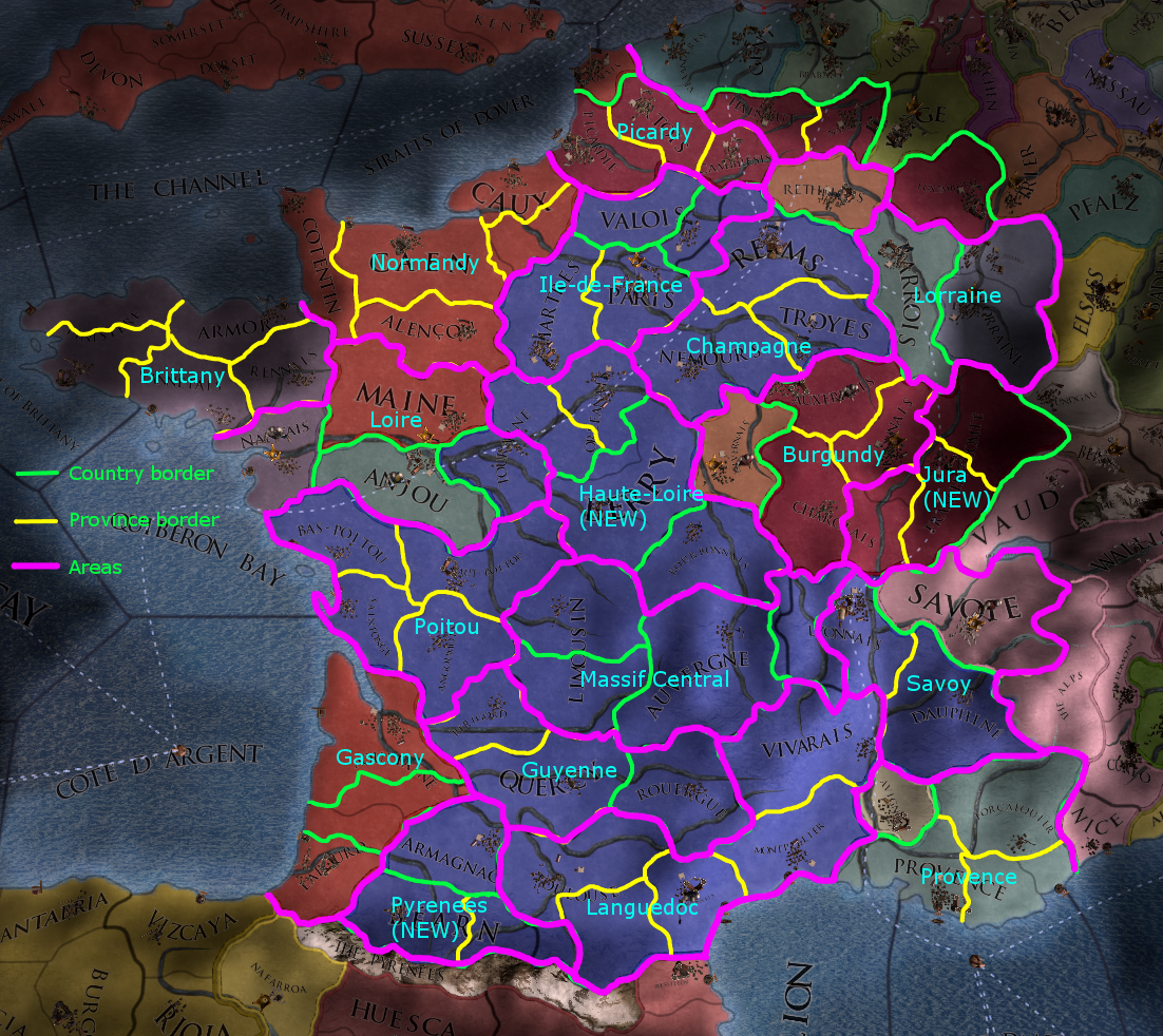
Areas.
I don’t know if this has been unique to just the last few updates, but more of the map changes seem geared around looking after the borders of areas (amalgamations of roughly 3-5 provinces strewn across the map), rather than trying to add a uniform number of provinces to every region. (Case and point Galicia, whose province count was increased from 1 to 4 in 1.28 almost certainly to justify giving it an area of its own).
Here’s just one proposal for how the revised map would handle areas:
With this proposal, 3 new areas are added: Haute-Loire (comprising the eastern half of the Loire Valley down to Bourbonnais), Jura (comprising all of Franche-Comte and the Maconnais, the areas closest to the Alps and the Beaujolais hills) and Pyrenees (Bearn, Foix and Armagnac).
These are the other main changes I made, along with my explanation as to why:
Nantais to Loire area. This was done to compensate for the addition of a sixth province to Brittany. It would make sense to include Nantais in this situation as the mouth of the Loire is entirely within the province. Also, a good part of Nantais is in the Loire Valley wine region (there’s a map of it in the links at the bottom).
Nemours to Champagne. The historical province of Ile-de-France never bordered Burgundy, with (most of) Nemours province being entirely part of Champagne. Nemours itself however was still in the Ile-de-France.
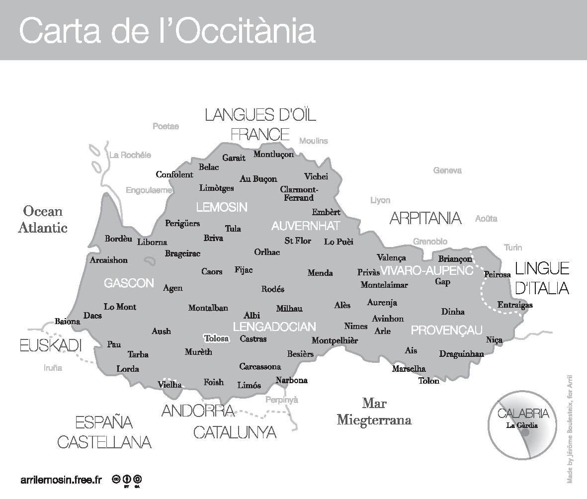
Bourbonnais taken out of Massif Central. I’ll delve into why I did this further in a forthcoming part on Occitania, but for now I’ve linked a map at the bottom of this post of the extent of the area of Occitania where the language was spoken. Note that Moulins, along with most of Bourbonnais, is outside the region.
Other than that, I tried to be as conservative with the areas as possible once again and only made a few significant changes from the original.
-Loire Valley wine region.
-Historical Champagne.
- Occitan speaking areas.
Development.
In the previous sub-part, although I did clarify what development the new provinces would have, I failed to make clear what changes would occur to the old provinces.
Note to @neondt , the exact value of development isn’t important, as these are just approximations. In most cases, a province that was split has had its development slightly reduced to compensate for the added development.
Leon (formerly Finistere): 10 -> 8 (-2)
Bordeaux (formerly Aquitaine): 21 -> 19 (-2)
Labourd: 10 -> 9 (-1)
Orleans: 17 -> 16 (-1)
Marseille (formerly Provence): 21 -> 18 (-3)
Dole (formerly Franche-Comte): 14 -> 11 (-3)
Valois: 14 -> 12 (-2)
Limousin: 10 -> 9 (-1)
Lyonnais: 20 -> 18 (-2)
Bearn: 12 -> 11 (-1)
Dijonnais: 20 -> 19 (-1)
The rest remain unchanged from where they were.
Other Notes.
No changes have been made to the trade map, however just to clarify:
-Foix will be in the Bordeaux trade node.
-Forez will be in the Genoa trade node.
-Vermandois will be in the Champagne trade node.
Also about forts:
-Narbonne's fort could be shifted to Carcassonne, as I mentioned before it was more strategically important.
Other than that, I'd keep all forts where they are. There might be a case for making Blois a fort, but I believe Orleans was more important in that regard, as it was at the northernmost point of the Loire and thus was the quickest way across the river, which had few bridges in the medieval era.
This concludes Part I.2. Hopefully this helped to clear up any previous technicalities, so that we can finally move on to the good stuff, in which I’ll be talking about the new nations to be put on the map in Part II.
I don't think you need to wait for everyone to agree on a point before going to another point. Even if everyone agree now on a point, some new people may join the topic and be disagreeing on a previous point. Everything is always open to discussion and as such we might be discussing a previous point later in the discussion.
ps: you really should rename "Occitania historical borders" with "Occitan speaking areas" in your last post.
I did a Southern France proposal in my first thread, perhaps you could find useful ideas.
My prefered provinces to be added are Toulon, Carcassone, Foix, La Marche and Bourg.
I know Albret was not very important, I only put it in the map because I think Aquitaine is too big, but I don't have other arguments than that for Albret.
I also think Bearn is too big, so I propose giving its eastern part to a new province called Bigorre.
I don't think you need to wait for everyone to agree on a point before going to another point. Even if everyone agree now on a point, some new people may join the topic and be disagreeing on a previous point. Everything is always open to discussion and as such we might be discussing a previous point later in the discussion.
ps: you really should rename "Occitania historical borders" with "Occitan speaking areas" in your last post.
I'm not waiting to go on to another point, this is just being uploaded in parts because it's much better to break down the big ideas into separate posts rather than cramming everything into one post. I'm also busy with other things IRL so I have to find the time to make these.
And yes I did change it to "Occitan speaking areas", thanks for the shout.


")