• We have updated our Community Code of Conduct. Please read through the new rules for the forum that are an integral part of Paradox Interactive’s User Agreement.
I assumed that the lack of sources was because of territorial flux. The maps from the 11 century didn't just spontaneously change when the 12-13th century started. You start in 1090 with borders similar to Roman Pannonia and then by the 1300s; You see major differences in county formation.

I meant some counties that only have one barony available, As I suspect some counties were. This way, you can use the history files to show the evolution of borders. I wish the CK3 barony system had more flexibility.
 
The 1090 borders you mention are not provinces, but dioceses. While to some degree they reflect the 11th century situation (major seats of bishops were contemporary important places), it is often very tricky to rely on diocese borders to define the political borders. Especially internal ones.

Fortunately, there are other (and better) ways we can reconstruct the situation of the 11th century division of Hungary. The borders of comitates have evolved, but in most cases, they were just older larger comitates breaking down into smaller entities.
Nitransko-Steinhubel.png

For instance this map covers the north of Hungarian kingdom, mainly Slovakia and you can see that Vác was originally a separate province, but later on - as we can see on maps describing 13th century, the province's capital moved to Buda and Vác itself joined the Nógrád province.

That said, the approach you described would fit well many of the areas - most of the later province seats already existed as castles or monasteries (or royal court-estates) already in the 11th century, so it is possible to use the later provincial administration as a base for land division, in which many counties would only have 1-2 baronies built up in the 11th century. I wish I could have a map like the one above for the entire kingdom of Hungary, that would help a lot.
 
  • 1
Reactions:
@nsinger998
so here I made a comparison of the current IBL's Hungary, which is in many parts basically the vanilla Hungary:
Hungary.png

The green lines are borders of historical comitates in the 13th century.
The blue lines are simulation of how would the current CK3 (IBL) duchies look, if they followed proper historical borders.

While I adapted the borders in the north according to the 11th century divisions, it is clear that some of the counties were changed a little (Eger, Nógrád and to a lesser degree the ones in the north east - although in the case of the Ungvar duchy I think it's because I haven't matched the historical borders with the CK borders well enough).
The southern and south-western part of Hungary is almost exactly accurate, some of the areas north of it are little simplified.

Now, would you be able to show on this map (or make better one), where do you think the changes should be done the way you described it? And what do you imagine with that territorial flux?
 
  • 3
Reactions:
In all my research; I could not find a source map for the vanilla De-Jure that was from before 1498. I did find this one:


I apologize for leaving it as a link. I could not find a better source for this pic which I feel is the best of both worlds. It resembles the vanilla De-Jure(reducing work) while making it possible to map counties and duchies in a way that resembles Roman Pannonia but also hints at later developments.
 
@nsinger998 Thank you for those maps. I'm sorry if there was some misunderstanding. There's no need to search for maps which look like vanilla map. It is beyond obvious that they used the ones depicting Hungary in 13th century, as well as other sources, like this one, in Hungarian.
hun.JPG

This is the map, which I used for comparison of the CK3 map and historical borders in my previous post, but only used the borders to make it look less confusing.


What I was asking was, if you could show, which particular parts of Hungary need changes. Show some clear example, please.
Above (in previous post) I have shown, that especially in Panonia, the vanilla borders do correspond with 13th century borders, as demonstrated on my comparison above. Those green and blue lines painted on CK3 vanilla/IBL map of Hungary are those 13th century borders.

Parhaps, could you use that CK3 map with those historical borders to show what exactly you expect to be changed?
I mean pick a county, name it and tell how do you think it should look. Just show a clear example. Would that be possible?

I do apologize for writing it this way, but it seems to me as if the two of us keep misunderstanding each other.
At least I still haven't managed to understand what you are asking and for a few successive posts I have been trying to get you to explain it. Unfortunately from your later posts I am increasingly more confused rather than having any clearer picture of what you want.
I'm very sorry for failing to understand it.
 
  • 1
Reactions:
I do think the Pula, Croatian and Dalmatian coast needs some love.
Yes, but sadly, that would have to be another mod. Balkans is a restricted zone for me. I don't hate myself enough to open that Pandora's box :oops:

In all my research; I could not find a source map for the vanilla De-Jure that was from before 1498. I did find this one:


I apologize for leaving it as a link. I could not find a better source for this pic which I feel is the best of both worlds. It resembles the vanilla De-Jure(reducing work) while making it possible to map counties and duchies in a way that resembles Roman Pannonia but also hints at later developments.
and for once more back to Hungary:
Here are little more detailed comparions.

First a better one where I used the 13th century map posted above:
Hungary-c13.png

Most of Hungary is really surprisingly close to those borders. Some places like the Netherlands would dream to be anywhere near this close to the actual historical borders.

Now, I forgot that I also do have a map of the first known counties as they existed in the 10th and 11th centuries. Here it is compared with the CK3 map:
Hungary-c11.png

it makes it clear that those borders which looked weird on the later map do make sense in the 11th century perspective.
Outside of Transylvania, there are exactly 2 small historical counties, which are missing on CK3 map. Some borders may look weird, but that changes when we put back those 13th century borders and add the 1090 map of Hungarian dioceses you repeatedly mentioned.
Hungary-all borders.png

From the combination of these 3 maps, the biggest breach of historicity seems the provinces of Eger and Heves, whose borders I adjusted in order to better fit a situation as depicted on the map I showed few posts above, which had Eger as independent county, which has disappeared already during the 11th century. Most of other differences are slight simplifications or things, which would require adding and/or moving a barony from one county to another. No big crazy changes, no big flux you spoke about.

To be honest, with this comparion, Hungary's counties seem far more stable than almost any other part of the map, and the CK3 depiction of the situation seems surprisingly accurate.

So now, you have it put all together. Could you please now show, what a map modder should do to make a better setup of medieval Hungary?
 
  • 1
Reactions:
You got me. I concede you as victor. But as a rome restorationist the only thing I could hope for is splitting Visegrade into Pilis and Pest; And Szekesfehervar into Fejer and Solt. I use the mod Title Manager extensively and Hungary's divisions tend to frustrate me.

Your mod, do as you will of course.
 
as a rome restorationist the only thing I could hope for is splitting Visegrade into Pilis and Pest; And Szekesfehervar into Fejer and Solt.
Thank you! Any historical backing for these - based in medieval period? If it makes sense in medieval era to split them, I most gladly will. If you could help finding some evidence, it would be nice.

Sadly, to be honest, you used the most unfortunate argument you could. Backing your request with being Rome restorationist sadly auto-generates a refusal reflex, because this mod's objective deffinitely is NOT to restore borders of an empire, which fell half a millenium before this game starts. I'm trying to overcome this reflex, but it would greatly help if you could help me with finding some medieval era backing for this split. Please.
And once again, thanks for putting down a suggestion

You got me. I concede you as victor
have I? I would have, if the discussion and all the effort I gave it, resulted in some clear and backed suggestion for which I wouldn't need to keep searching. The result is quite the opposite.
While you did search for a map which would fit vanilla setup, which is appreciated, unfortunately it wasn't what I needed from you. And in the end, after doing the comparison, it appeared that the vanilla map is actually even closer to historical accuracy than I originally assumed.

Which means I lost, because after more than a week of trying to get a suggestion, all that came from this discussion was a suggestion to split 2 counties with very vague backing.
 
Last edited:
The only historical backing I can think of is these maps:

post #162 of this topic has a map showing Visegrad, and Buda as part of a larger Visegrad county. Tata is part of Gyor with Komarom and Esztergom completly across the Danube except for Esztergom city.

https://www.google.com/search?q=kin...lJGUyAs&bih=770&biw=1540#imgrc=HeQUQIBkwBBI0M

The above map does show Szekesfehervar split into Fejer and Solt but its probably to show the different tree density.

And finally, just for the heck of it, A map of Hungary just before the Magyar invasion of the 9th century:

Gesta_hungarorum_map.jpg
 
  • 1Like
  • 1
Reactions:
Hi all,

After a long radio silence I have some good news.
- The first is personal and from the mod's perspective actually a negative one - the long pause was caused by some pretty great personal news in RL due to which I am going to have much more limited time. But things are slowly settling down and I am back to at least some modding and working on an update again.
- Due to the news above, I tried to ask a fellow modder for help and one of the feedbacks was positive, so with his help I hope we will be able to deliver updates slightly faster than my current work pace.

Most importantly, one tiny (very tiny) update is already ready and uploaded for you. For now it is just a small fix of some missing/misplaced locations, but more is in the kitchen getting ready for you.

One of the good news about upcoming further updates is that I am finally adding also some graphical stuff to the map. For instance that the map textures are being updated to fit the changes of terrain, like these few examples:
2021_10_29_4.jpg


2021_10_29_5.jpg


That's all for now. More to come.. hopefully sooner than later
 
  • 1
  • 1Like
  • 1
Reactions:
You actually got it to read the terrain files in your mod file? Anytime I've tried that and think it's working it's only since it's reading the changes it initially put in the game folder.
 
You actually got it to read the terrain files in your mod file? Anytime I've tried that and think it's working it's only since it's reading the changes it initially put in the game folder.
Yes, initially the editor makes the changes in the original game (vanilla) files.

But once you move the files into the same structure in your mod directory, both the game and the editor reads them from there and the editor does all additional changes directly in the mod directory/files. And they work even after validating and restoring the original vanilla files
 
Last edited:
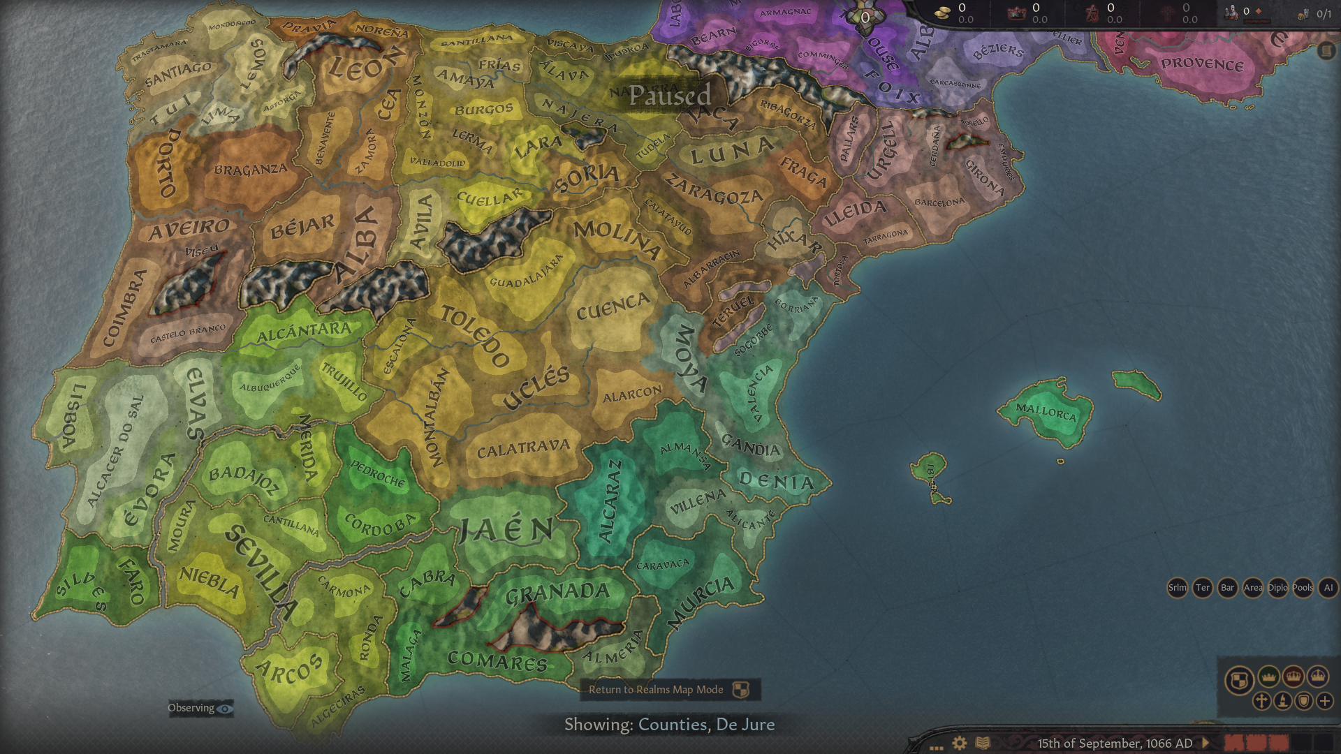
After a while, here are some news about the Iberian update of Ibn Battuta's Legacy.
2021_11_03_1.png

The basic structure of province history files is now ready and in the next phase I will do the details such as editing the holding types.
Currently I am also looking for some rulers to fill at least some of the additional counties, as well as to add historical characters which the vanilla have missed.
One example is a Zirid emir Maksum, the son of 1066's emir of Granada, who should be ruling in Jaén, I will also be adding the Banu Razin to Albarracín (and most probably also Teruel) and Banu Qasim to the new county of Sogorbe...

Anyway, I am looking forwards to seing your feedback about the cultural borders in 1066,
2021_11_03_5.png

This is how it looks now. I'm not perfectly sure about Toledo for instance - this is how I copied it from the vanilla, but I feel like Toledo should probably be still Andalusian rather than Castilian, like I did it with Tudela.

Also feel free to post suggestions if you have ideas of what characters are/were missing in the vanilla setups.
 
  • 4Like
  • 1Love
  • 1
  • 1
Reactions:
while the work on the update of Iberia is progressing slowly, I decided to release another relatively minor update, yet important in terms of progress towards compatibility with other mods from Community Mods for Historicity.

The mod has been updated on both it's Paradox mods page as well as on Steam

The new update contains a new terrain type, called Boreal Highlands.
2021_11_27_2.png


Boreal Highlands are there to distinguish nordic mountains and hills from regular hills of Temperate areas. They are more hostile than regular hills and mountains, generally they cover those hills and mountains which have pine trees.

2021_11_27_3.png


This new terrain covers areas such as Iceland, Scotland's Highlands, Scandinavian mountains as well as the uplands of Siberia
2021_11_27_1.png
 
  • 2
  • 1Like
Reactions:
Would parts of Tibet not fit that kind of terrain?
 
Would parts of Tibet not fit that kind of terrain?
that's a good point.
OTOH I thought about this terrain as specific Nordic-Siberian thing, with frequent moss, pine trees etc.
Tibet, as far as I know is on the other hand quite arid and that's why it keeps its current terrain.
 
The vast majority of Tibet is tundra or cold desert. I'd expect the valleys in its far east to be boreal though.
 
Last edited:
The vast majority of Tibet is tundra or cold desert. I'd expect the valleys in its far east to be boreal though.
Thanks for feedback.

I'm discussing it with the team of Sinews of War mod (at whose request this terrain was added).
They definitelly agree that something shuold be changed in Tibet, but we need to sort out whether it should be Boreal Highlands (which are in my opinion little too humid for Tibet) or some other terrain type.
 
now something slightly ubrelated to the mod... but I have just finnished making a map of 11-12th century Bohemia & Moravia with some more detail than my previous effort... and wanted to share it here with you:


Země_Koruny_české_EN.png


it also sort of implies that I will do some minor changes to my current setup of Bohemia & Moravia (once again)
 
Last edited:
  • 3Love
  • 1Like
  • 1
Reactions: