

I'd suggest one for Central Asia; Tashkurgan is in the entirely wrong place, for example.Then, after all this, some regional province overhauls might be in order
Map scale
- Thread starter DarkReborn
- Start date
-
We have updated our Community Code of Conduct. Please read through the new rules for the forum that are an integral part of Paradox Interactive’s User Agreement.
You are using an out of date browser. It may not display this or other websites correctly.
You should upgrade or use an alternative browser.
You should upgrade or use an alternative browser.
I don't really know where to post this, so I'll put it here; now that the map files are much more flexible in their modification, I'm adding back some of the provinces that had to be converted into others due to the modding difficulties of the pre-RoI map files. I'm already done with Europe, North Africa and the Middle East (the number of provinces that had to be restored in these three in total were no more than 10), with Eastern Europe and the Steppes to be done. After this I'm polishing the easternmost border, manly removing that ugly Terra Incognita province that had to be added, again due to the peculiarities of the old map system.
Then, after all this, some regional province overhauls might be in order; Arabia's is probably the first to come since we have a provincial setup already planned for it.
Care to share it? I was working on some map embellishment and on the "improved" mountain ranges, but I don't want to work with outdated material.
I also think North Africa, Egypt, the Levant and India need more provinces. I made this setup with Egypt, for instance:
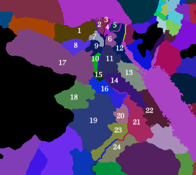
I'm also considering cutting down Alexandria or splitting it, but I don't know. Alexandria sounds more like a city-state than anything else, right? -- Ignore, by the way, the Sinai desert, I added it for my own game because I like it, but it's mostly flavour.
NOTE: The ? signs mean that I just didn't make full research, I just used some maps of old Egyptian nomoi and Roman Aegyptus cities, so parts of Egyps remain a bit unclear as of now.
1 - Alexandria
2 - Sais
3 - Busiris
4 - Bubastis
5 - Avaris
6 - Cairo / Heliopolis
7 - Memphis
8 - ?
9 - Arsinoe / Lahun
10 - Herakleopolis
11 - Antinoe / Cynopolis
12 - ?
13 - Alabastria
14 - Ptolemais
15 - Hermopolis
16 - Lykopolis
17 - Siwa
18 - Oasis Magna / Hibe
19 - ?
20 - Hieracompolis
21 - Elephantina
22 - ?
23 - Buhen
24 - Premis
25 - Dendera
26 - Thebes
Last edited:

It was proposed by Futuregary back when he was still working on the map. Though I plan on reducing the general number of provinces a lot.
Care to share it? I was working on some map embellishment and on the "improved" mountain ranges, but I don't want to work with outdated material.
I also think North Africa, Egypt, the Levant and India need more provinces. I made this setup with Egypt, for instance:
I'm also considering cutting down Alexandria or splitting it, but I don't know. Alexandria sounds more like a city-state than anything else, right? -- Ignore, by the way, the Sinai desert, I added it for my own game because I like it, but it's mostly flavour.
NOTE: The ? signs mean that I just didn't make full research, I just used some maps of old Egyptian nomoi and Roman Aegyptus cities, so parts of Egyps remain a bit unclear as of now.
1 - Alexandria
2 - Sais
3 - Busiris
4 - Bubastis
5 - Avaris
6 - Cairo / Heliopolis
7 - Memphis
8 - ?
9 - Arsinoe / Lahun
10 - Herakleopolis
11 - Antinoe / Cynopolis
12 - ?
13 - Alabastria
14 - Ptolemais
15 - Hermopolis
16 - Lykopolis
17 - Siwa
18 - Oasis Magna / Hibe
19 - ?
20 - Hieracompolis
21 - Elephantina
22 - ?
23 - Buhen
24 - Premis
25 - Dendera
26 - Thebes
The province setup looks pretty good! When I get to Egypt I'll probably use this. As for India... if I ever get to it I'll probably use vanilla as a base since it's setup seems roughly better than US/Ours.
But looking elsewhere on the map you posted (If it was a proposed map for those parts in LI, otherwise I apologize in advance), and as I've said before in this thread before, I'm not a fan of adding more wasteland provinces unless it's absolutely necessary, I don't see a reason other than immersion for them; and that doesn't justify the eyesore they provoke on me.
It was proposed by Futuregary back when he was still working on the map. Though I plan on reducing the general number of provinces a lot.
I like it. Less provinces, yes, but reduce them mostly on the interior, I think it's the best option. After all, the southern coast was the most densely populated, followed by the Aqaba-Mekka strip and the Oman area.
The province setup looks pretty good! When I get to Egypt I'll probably use this. As for India... if I ever get to it I'll probably use vanilla as a base since it's setup seems roughly better than US/Ours.
Thanks, I'll upload the full bmp provinces image when I'm done with some rearrangements in England and Ireland.
--
By the way, I thought that the "Suez Canal" we were implementing was Necho's Canal, which didn't follow the Suez route, but this one:

It would certainly make a more interesting gameplay, since to cross into the Red Sea you'd need to dominate the Nile Delta, at least in the naval sense. There was also the Persian Canal and "Trajan's River". I had read about the Persian Canal that connected the Nile directly with the Red Sea, but I had heard nothing about Trajan's Canal, which is listed on Wikipedia. Any input on this one? I think it refers to a series of Roman overhauls of the canal network that connected the Nile with the Sinai shore, the ones that also shifted the weights of the area into the Babylon fortress (the Egyptian Babylon, of course) and trade center (which would become Cairo after the Muslim conquest).
But looking elsewhere on the map you posted (If it was a proposed map for those parts in LI, otherwise I apologize in advance), and as I've said before in this thread before, I'm not a fan of adding more wasteland provinces unless it's absolutely necessary, I don't see a reason other than immersion for them; and that doesn't justify the eyesore they provoke on me.
Well, it was a work in progress. And yes, it was immersion, so I plan on working with you for the general map and then maybe release a small module that just adds the "eyesore"
")
Here you have my latest versions. The Syrian desert is still just a rough draft, as you can see Palmyra has been ignominiously displaced. This will change!
And here's my version of Spain. No added provinces, just rearranged so that they make more sense. THere are three mistakes (like unnecessary impassable mountains in Granada and Asturias), but I'm quite happy with the result.
Which, by the way, brings me to the point: should we use the reduced borders mod? It makes the borders thinner and more stylised, perfect for smaller or more twisted provinces.
Tibet, Persia, Central Asia and Spain look pretty good. I specially like the latter two; Spain's rearrangement is much needed, and for the first time on history, I agree on that there should be a wasteland province in the middle of the Tarim basin. But the Syrian desert, I don't know. It could work as a submod as you say, but using it for the main map...
About the Sinai canal; the problem with using Necho's Canal is that the Nile "provinces" count as river provinces... thus they can only be traversed right now (in LI) by the Norse and Egyptian religions.
About the provinces.bmp, yeah, just upload it and I'll integrate it into my actual work of adding back the lost provinces when I'm done with it.
Which mod is the reduced borders one?
NBRT+, which I'd integrated during my time as mod lead, but the main thread OP says was redacted as requested... and since I was absent for the redaction, I don't know the circumstances.
NBRT+, which I'd integrated during my time as mod lead, but the main thread OP says was redacted as requested... and since I was absent for the redaction, I don't know the circumstances.
Ah yes... I don't remember correctly, but I believe it's creator retired from modding and didn't want the mod to be around in mods other than the HIP compilation. Riknap was the one who was asked to remove it IIRC, so he might have a better explanation.
the mod author, EQQE (?) had a.. falling out with Paradox, and requested all mods which bore his material to pull it out. While he's returned to the scene, he now exclusively allows permission only for SWMH (CK2) and MEIOU&T (EU4), where his work is integrated by default. That said, the current borders work was something I personally made (though I did base the idea on the reduced borders mod of NBRT+), so I don't mind working on it again to make it fit. ... when I can use my PC again that is (it's like Fate mocks me, as my OS installation in my HDD got corrupted somehow, and I need to reinstall windows and all from scratch). Probably within a couple of days anyway...Ah yes... I don't remember correctly, but I believe it's creator retired from modding and didn't want the mod to be around in mods other than the HIP compilation. Riknap was the one who was asked to remove it IIRC, so he might have a better explanation.
If we redo the borders / waste land, please separate the Tarim Basin in two, as the North and the South could not communicate directly with each other due to the Taklamakan. FG had put this on his to do list but has now retired.
PS: which "Tahkurgan"? You have Tashkurgans at every corner in the Turkic world Anyway the "one" Tash Kurgan you refer to should be renamed to a non-Turkic name, but I did not work too much in this area yet. A Wakhi name should be appropriate, but well I don't really know Wakhi so well so a little research would be needed... all this is in my mind for Central Asia 2.0 :closedeyes:
PS: which "Tahkurgan"? You have Tashkurgans at every corner in the Turkic world
Anyway the "one" Tash Kurgan you refer to should be renamed to a non-Turkic name, but I did not work too much in this area yet. A Wakhi name should be appropriate, but well I don't really know Wakhi so well so a little research would be needed... all this is in my mind for Central Asia 2.0 :closedeyes:Tibet, Persia, Central Asia and Spain look pretty good. I specially like the latter two; Spain's rearrangement is much needed, and for the first time on history, I agree on that there should be a wasteland province in the middle of the Tarim basin. But the Syrian desert, I don't know. It could work as a submod as you say, but using it for the main map...
Thanks; for the most part, I just tried to make the impassable mountains fit the actual elevtions of the map in Tibet and Central Asia.
As for the Syrian Desert, I think it's much needed, since that area was a wasteland. However, it could be crossed by caravans and nomads, that's why I added some oasis, but I agree that it can clash with the Palmyra setup, for instance. We can work something out.
About the Sinai canal; the problem with using Necho's Canal is that the Nile "provinces" count as river provinces... thus they can only be traversed right now (in LI) by the Norse and Egyptian religions.
Hmmm, true... I guess we can still have a "river" province to represent the Persian Canal, right?
If we redo the borders / waste land, please separate the Tarim Basin in two, as the North and the South could not communicate directly with each other due to the Taklamakan. FG had put this on his to do list but has now retired.
I have already tried. Although there's a river/wadi that connects the two sides of the Taklamakan in the westernmost part, but for the rest I added a wasteland there.
***
By the way, I'll repeat my propoal for Barcelona to be included into K_Septimania or K_Gothia, maybe having Tarraco remain within Valentia, since it's essentially Roman. You could even do this:
Ilerda - to Gothia.
Tarraco - to Valentia
Barcino, Empuries, Rosselló, Urgell - to Septimania
At this stage, and given the circumstances, "Catalonia" isn't a thing yet, and without any Reconquista in sight I don't see why Barcelona should encompass areas that it has never occupied or controlled. I even suggested to Shaytana, in the beginning, to rework Occitan and have it represent both archaic Catalan and Oc Language. After all, the two languages didn't become fully fledge languages (instead of dialects of an older Pyrinean-Romance tongue) after the XIIth Century.
***
Another question: are we doing more-provinces-fest? I like that kind of fest
More provinces proposals are good. Areas that I think need more provinces are:- North Africa
- Andalusia
- Southern France, Provence and Italy.
- England and Ireland.
- Sogdia
- the Indus valley
- the Rhineland
- Greece and Anatolia
- the Levant
- Eastern Africa (the Swahili Coast)
I know more provinces means more lag, and that it's a ton of work, but I find myself quite motivated. More provinces and better layout is one of the things I have missed the most in LI from the start.
Last edited:
I'll think about the Syrian Desert's wastelandization ( Wastelanding? Wastedization? Whatever... ), but I'm still not entirely convinced ( though I'm comparatively more convinced towards it than I was in the past, this damn stubborn Aragonese attitude often gets the best of me :laugh: ) by it being a giant wasteland province right there with all the little oases.
Maybe something like it has been done in EUIV 1.8? A small "Badiyat al-Sham" province the size of the Rub al-Khali one, while the rest of the province layout is moved around it but not removed.


---
As for the de-jure layout "split" of Barcelona... I'll think about it. For the moment I'll let it as it is right now ( Mostly because Richvh is working on properly updating the tech history on a duchy basis and I don't want to disturb his work ), but be assured that it will be looked at eventually, and I'll possibly use your proposal.
---
The province revision... as I said, upload your layout proposals and I'll eventually have a look at them, but the province overhaul is a very long term thing... mostly because I tend to get distracted by things I'd like to work on LI, or remember things I should be working on, or things that have been half-finished for a bazillion years (the Nomad system is the prime example, I just don't know how to complete it or make it a good gameplay mechanic). My modding workflow is very... anarchic, and it's something I don't plan on changing, for good or ill :laugh:.
Maybe something like it has been done in EUIV 1.8? A small "Badiyat al-Sham" province the size of the Rub al-Khali one, while the rest of the province layout is moved around it but not removed.
---
As for the de-jure layout "split" of Barcelona... I'll think about it. For the moment I'll let it as it is right now ( Mostly because Richvh is working on properly updating the tech history on a duchy basis and I don't want to disturb his work ), but be assured that it will be looked at eventually, and I'll possibly use your proposal.
---
The province revision... as I said, upload your layout proposals and I'll eventually have a look at them, but the province overhaul is a very long term thing... mostly because I tend to get distracted by things I'd like to work on LI, or remember things I should be working on, or things that have been half-finished for a bazillion years (the Nomad system is the prime example, I just don't know how to complete it or make it a good gameplay mechanic). My modding workflow is very... anarchic, and it's something I don't plan on changing, for good or ill :laugh:.
I mean this one. Last time I played Lux, it was to the west of Kashgar.PS: which "Tahkurgan"? You have Tashkurgans at every corner in the Turkic world
Also, would you guys like a map of the thirty-six Tocharian city-states the Han recorded?
Last edited:
Care to share it? I was working on some map embellishment and on the "improved" mountain ranges, but I don't want to work with outdated material.
I also think North Africa, Egypt, the Levant and India need more provinces. I made this setup with Egypt, for instance:
I'm also considering cutting down Alexandria or splitting it, but I don't know. Alexandria sounds more like a city-state than anything else, right? -- Ignore, by the way, the Sinai desert, I added it for my own game because I like it, but it's mostly flavour.
NOTE: The ? signs mean that I just didn't make full research, I just used some maps of old Egyptian nomoi and Roman Aegyptus cities, so parts of Egyps remain a bit unclear as of now.
1 - Alexandria
2 - Sais
3 - Busiris
4 - Bubastis
5 - Avaris
6 - Cairo / Heliopolis
7 - Memphis
8 - ?
9 - Arsinoe / Lahun
10 - Herakleopolis
11 - Antinoe / Cynopolis
12 - ?
13 - Alabastria
14 - Ptolemais
15 - Hermopolis
16 - Lykopolis
17 - Siwa
18 - Oasis Magna / Hibe
19 - ?
20 - Hieracompolis
21 - Elephantina
22 - ?
23 - Buhen
24 - Premis
25 - Dendera
26 - Thebes
Looks good, though if I may suggest something what might be worth taking into consideration:
1) the tiny provinces in the Delta may in the end be little too small. It's my experience from designing Egypt for SWMH what makes me write this - Also we had rather many tiny provinces there only to realize that it was both unrealistic and bit hard from gameplay POV - the region was highly centralized so it might be better represented by lower number of provinces with high number of holdings.
2) I'm not sure if the Nile should actualy divide the provinces in Egypt, especially in the Upper Egypt. The river was a unifying, not divisive factor of Egypt's life. You can always have a province lying on both banks of a major river.
Last edited:
I knew you were speaking of this one dude! (I spent 2 nice nights thereI mean this one. Last time I played Lux, it was to the west of Kashgar.
Also, would you guys like a map of the thirty-six Tocharian city-states the Han recorded?
) This was just a joke about the frequent occurrence of this name. My point is that people in Tashkurgan are still not turkified and speak mostly Wakhi, using Uygur only for exchanges with "the rest of the world". So in LI using a Turkic toponym when Uygurs are still far off is wrong... At some point it has to be renamed. I have good sources for Central Asia including City States in the Tarim, which I plan to use for a future Central Asia 2.0 overhaul, but I welcome your own. This map sounds interesting...
Here it is. Ignore the coloured blobs; that's the new province layout for DK. The map is from JP Mallory and Victor Mair's The Tarim Mummies.I have good sources for Central Asia including City States in the Tarim, which I plan to use for a future Central Asia 2.0 overhaul, but I welcome your own. This map sounds interesting...
Looks good, though if I may suggest something what might be worth taking into consideration:
1) the tiny provinces in the Delta may in the end be little too small. It's my experience from designing Egypt for SWMH what makes me write this - Also we had rather many tiny provinces there only to realize that it was both unrealistic and bit hard from gameplay POV - the region was highly centralized so it might be better represented by lower number of provinces with high number of holdings.
2) I'm not sure if the Nile should actualy divide the provinces in Egypt, especially in the Upper Egypt. The river was a unifying, not divisive factor of Egypt's life. You can always have a province lying on both banks of a major river.
What about this:
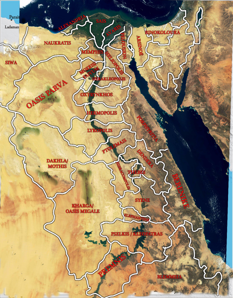
I have supressed two Delta provinces, but added Alexandria, which seems to me much needed, since it was always Alexandria apud Aegyptus, "beside Egypt", and never fully "inside" it. Since it's a metropolis, I think it's a good idea if we can have the Mouseion, the City and maybe even the Lighthouse (turned into some kind of fortress by that point, like the Colosseum was) as separate holdings.
This is the duchy map I propose. The Oasis duchy, as much as I like it, can be supressed and partitioned between the neighboring duchies, as I've marked in the map itself. As for the rest, they're based off Byzantine provincial administration, with a bit of Ptolemaic nomenclature thrown in.
You know that I'm nowhere near being a specialist on pre-islamic Egypt, so I can hardly comment on anything but major socio-political-economic features/trends that are constant in Egypt. So please don't consider my notes as normative objections but rather as questions which I believe you should have answered (and as I believe you already have)What about this:
I have supressed two Delta provinces, but added Alexandria, which seems to me much needed, since it was always Alexandria apud Aegyptus, "beside Egypt", and never fully "inside" it. Since it's a metropolis, I think it's a good idea if we can have the Mouseion, the City and maybe even the Lighthouse (turned into some kind of fortress by that point, like the Colosseum was) as separate holdings.
This is the duchy map I propose. The Oasis duchy, as much as I like it, can be supressed and partitioned between the neighboring duchies, as I've marked in the map itself. As for the rest, they're based off Byzantine provincial administration, with a bit of Ptolemaic nomenclature thrown in.
I think it looks fine. Due to little different estethic preferences I would have drawn the provinces little differently, but that's just subjective estethic thing which should be ignored
As far as I know the history of Egypt I think that the oasis duchy has its legitimacy - at least in the Islamic times it has certainly existed, not sure how it was before.
More objectively speaking (but again with strong personal and thus subjective influences) I wouldn't be affraid to push the borders of the extra-Nile provinces little towards the river. The fertile and inhabited area by the Nile was very narrow and I don't think that these provinces 'on the Nile' should stretch too far into the desert, they should rather leave that space for desertic provinces. But it is largely influenced by the way how you want Egypt to look on the general map itself and I understand many people prefer its look to be more similar to its recent political borders rather than a strip around the Nile.
The last thing is - shoudn't the Premnis province be rather part of Nubia than Egypt? In Islamic time this was already Nubia, and I thought the Nubia-Egypt border of Islamic time was derived from pre-Islamic border, but I may be pretty much wrong in this case.
You know that I'm nowhere near being a specialist on pre-islamic Egypt, so I can hardly comment on anything but major socio-political-economic features/trends that are constant in Egypt. So please don't consider my notes as normative objections but rather as questions which I believe you should have answered (and as I believe you already have)
By all means
I think it looks fine. Due to little different estethic preferences I would have drawn the provinces little differently, but that's just subjective estethic thing which should be ignored
As far as I know the history of Egypt I think that the oasis duchy has its legitimacy - at least in the Islamic times it has certainly existed, not sure how it was before.
Good to know. I know that these oasis were institutions on their own, and there were two administrative divisions in Roman Egypt for Oasis Parva and Oasis Magna (Magna being the union of the Kharga and Dakhla oasis), so I thought it was fitting to have a duchy for them. It also works well with the setup.
More objectively speaking (but again with strong personal and thus subjective influences) I wouldn't be affraid to push the borders of the extra-Nile provinces little towards the river. The fertile and inhabited area by the Nile was very narrow and I don't think that these provinces 'on the Nile' should stretch too far into the desert, they should rather leave that space for desertic provinces. .
I know, but I tried to do bigger provinces. If I had it my way I'd have the strip of land around the nile and desert everywhere else.
But I have drawn it this way for two reasons:
1- Visibility and clarity: to give the appearance of a developed state structure that can control the hinterland.
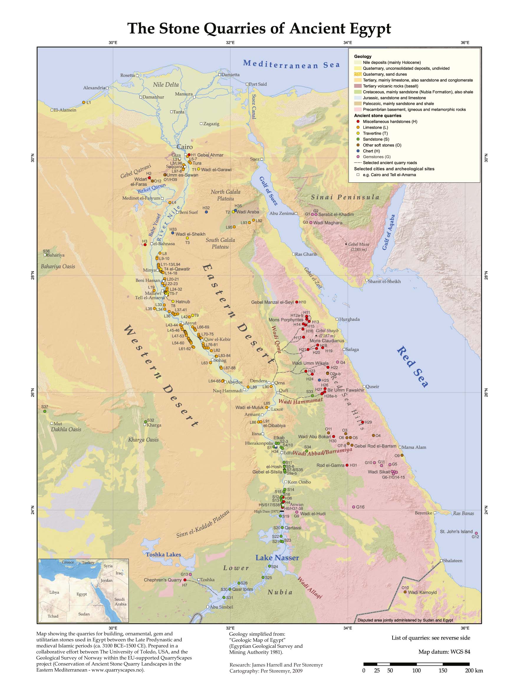
2- If I draw the river provinces strictly into the fertile area around the Nile, then I don't really know what to do with the hinterland. Adding more provinces in the desert seems like a waste. I could expand the coast ones, yes, but that would looks funny. In Ptolemais and Hermopolis, for instance, I used the range around Mons Claudianus as a natural border for the provinces and their "reach" into the desert. There were quarries there, therefore population, centers of work and transporation, etc:. Here's one of the maps that shows the quarries and trade-and-transport centers:
But I can rework it, of course. And I agree that the Lybian Desert provinces probably should keep their borders closer to the Nile... I can rework it so that the province Porphyrica/Porphyritia engulfs all those quarries, although then Egypt would have direct contact with the Red Sea shore, and that shore was (or appears to have been, I've never bought it entirely...) quite devoid of Egyptian, Ptolemaic or Roman activity. The Red Sea Hills are very inhosipitable, but over the years some systems of hostels and small herdsmen villages could have developed, makign the trip easier...
The last thing is - shoudn't the Premnis province be rather part of Nubia than Egypt? In Islamic time this was already Nubia, and I thought the Nubia-Egypt border of Islamic time was derived from pre-Islamic border, but I may be pretty much wrong in this case.
Yes, yes it should... a slip from my part.
Note: I will adjust the de jure set up of some duchies in Persia / Central Asia to the new physical boundaries. De jure Karmania should not extend any more to inaccessible deserts, for example.