• We have updated our Community Code of Conduct. Please read through the new rules for the forum that are an integral part of Paradox Interactive’s User Agreement.

BongBong

Corporal
13 Badges
Dec 13, 2016
37
108
  • Europa Universalis IV
  • Europa Universalis IV: Art of War
  • Europa Universalis IV: Conquest of Paradise
  • Europa Universalis IV: Wealth of Nations
  • Europa Universalis IV: Call to arms event
  • Europa Universalis IV: Res Publica
  • Europa Universalis IV: Pre-order
  • Victoria 2
  • Europa Universalis IV: El Dorado
  • Europa Universalis IV: Common Sense
  • Europa Universalis IV: Cossacks
  • Europa Universalis IV: Mare Nostrum
  • Hearts of Iron IV: Cadet
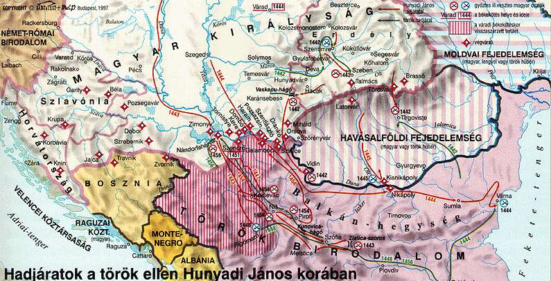
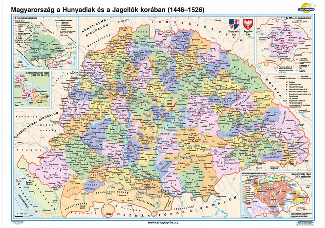
Serbia and Wallachia had a historical border that i believe was there but it was removed,why is that?

I rarely see ottomans expanding directly into Hungary without taking Serbia or Wallachia first. My guess is that so the balkan Nations can call Hungary into war with ottomans and promise them land? Or so Austria can have guaranteed military access in order to be able to fight the ottomans?

I still think that Serbian-Wallachian border is more important so that these two nations can expand into each other,and also Austria can always ask Serbia or Wallachia for access,i doubt they would refuse.

EDIT:
 

Attachments

  • map-eu-se-1444.jpg
    map-eu-se-1444.jpg
    267,6 KB · Views: 249
Last edited:
  • 5
Reactions:
Upvote 0
John Fine = John von Antwerp Fine?

I read a lot of Hungarian sources, but from von Anterwp I only read Late Medieval Balkans: a Critical survey... but I found that real superficial! Hungarian sources are a lot more detailed!

For example did you know what this peace meant? Why did they have to sign it, I mean why was this deal was so tempting (Both Wladyslaw and Hunyadi)? Because J.V.A. writes two sentences about that, that the Despot was very happy and then something about Wladyslaw's advisors and the Cardinal's excuse. But do you know what really happened in the background?

Perhaps you can expound upon it?
 
Very interesting thread (or rather threads, as I see there are at least 3 similar active threads!)
I agree with many points brought up here:

Most imporantly, Belgrade/Nandorfehervar should be represented separately, with a fort. It was arguably the most important fort in the area, under strict Hungarian control. Obviously it should have serbian population, with orthodox religion.
Also agree that the Hungarian "Vegvar zone" was of utmost importance in the various Ottoman-Hungarian wars. Belgrade, and for various parts in history the many important castles in the area of Smederevo/Szendro and Golubac/Galamboc should also be represented.
(I'm thinking about expanding the Vegvar strip of the Belgrade and Smederevo provinces to the northern parts of Bosnia as well. This was also mentioned in one of the threads, would be great to have it this way, but not as important as the northern Serbian parts. If I do this, it would be a separate Hungarian controlled province, with Srebrenik as it's capital)

About the border between Serbia and Wallachia: I'm on the side that it should be there.
It could have been either way in 1444, and I doubt that we will ever have any real facts about it.
For my taste it makes more sense this way, mostly for the potential later border conflicts. But actually I consider this a rather minor issue, I could live with it either way.

Here is how I had it in my personal mod:
Both Belgrade (with a Fehervar/Nandorfehervar shown as a dynamic name for Hungary) and Smederevo have a fort.
Smederevo is the capital of Serbia (and yeah, it's on the wrong side of the river, but looks good this way, and still way better than the current position)
The big Srbija province is the original one (pre 1.18), with Krusevac as the provincial capital.

serbian_situation.jpg
 
Last edited:
  • 8
Reactions:
Srebrenik is an interesting place, I'm so glad you mentioned it! :D

LOOOK AT THE FORT!

CnNChdJWIAAIynS.jpg


7979520919_edcab25a28.jpg


300px-Let_vrtulnikem11_-_hrad_Srebrenik_(13.-18._stol.)_jeste_lepe.jpg


In my opinion it is too small to put in the game, and there's no option to fulfill its historical role anyways.
It was a fort with a maximum of 250 men garrison (if I remember well) with 2 silver mines. Maybe that's why It switched owners between and 1400 to 1463 22 times(!!!).

On the Hungarian side of things we spoke about the military and provincial aspects of the southern fort system called the "Végvár"-system. But it also created some new offices called bans. Hungarian Kings lifted smaller, military based territories to provincial rank. There were some other provinces (Croatia, Dalmatia, Slavonia) where the Ban was already a worthy office and giving the same office to other Hungarian nobles meant a prestigous mission for families, and also it gave some opportunity to "annex" neighboring christian lords into Hungarian feudal system peacefully. In that fashion there was a Ban of Bosnia, Jajce, Srebrenik, Macsó(Macva(?)) Szörény(Severin) and Nándorfehérvár. From these new leaders only the Ban of Macsó and Nándorfehérvár were influential, others considered minors. The Ban of Nándorfehérvár was always the "nádor" (2nd in command after the King). The nádor (or his chosen representative neither the fort nor the title were given to any (other) noblemen. This title was also come with an other title, The Vice-Nádorispán of Croatia, Slavonia and Dalmatia.

For the map I made some (and maybe still making my suggestions in this thread)
 
Perhaps you can expound upon it?

We have to start the story at Titel, where Albert von Habsburg died. His wife was pregnant, and nobody knew if she'd give birth to a son or a daughter. Ulrich of Celje who was heir to the Bosnian throne and had some interest in Styria too was a great supporter of House Habsburg, but Hungarian nobility didn't want another queen mother with an infant king when it was a time of great need, they wanted a warrior King which they found in Wladyslaw of Jagello from Poland. The Queen gave birth on 22th of February 1440 to Ladislaus von Habsburg, who got the nick "Posthomous", because he was born after his father's death.

So in 1440 February when It was inevitable, that nobles will coronate Wladyslaw, Ladislaus' mother stole the crown, and coronated the newborn Ladislaus with it. Wladyslaw had to hold the ceremony with a fake crown, Habsburgs fled the country to west leaving some garrisons.The Habsburgs seeked support from George of Brandenburg, who patron Ladislaus from the beginning. But George was a rather a drinker, and taught Ladislaus who to behave at noble parties later, but that's an other story for an other day. Other supporter of Ladislaus' claim was Jan Giskra Bohemian mercenary captain. Giskra managed to cut Wladyslaw's supply lines to Poland, and was a real pain in the ass.

In 1440 Wladyslaw sieged Győr, and in the following year slowly pushed out the queen's soldiers from the country winning a decisive battle at Bátaszék. Fighting in 1442 was not as fierce as it was in prevoius years, as the Habsburg side exhausted their strength and at the beginning of the year Ottomans tried to take advantage of the Civil war. In 1442 dec, the two sides signed a two-year armistice on papal pressure (because of Hunyadi's successes in 1442).

Upon seeing this struggle the sultan thought that if Hunyadi is Transylvanian Duke and Nándorfehérvár Ban at the same time plus he is a big supporter of Wladyslaw, then Transylvania would be an easy prey, they were wrong. Mesid bey of Vidin came with an army consisting of 30k light soldiers against the 10k "handmade" army of Hunyadi. In the battle of Marosszentimre, Hunyadi lost, and almost died, but the Turkish didn't chase, instead they went to the wealthy Saxon town of Szeben (Sibiu).

Then Mesid bey decided after that the whole point of the campaign will be Hunyadi, dead or alive!

This information came to gossip Hunyadi also heard it, and built his whole strategy around it. He made an Achilleus-maneuver.
Gave his armor to Kemény Zsigmond and gave order to him, that with 500 soldiers bait the turks out of their camp. Turks ate the bait and massacred the 500 Hungarians. In the meantime Hunyadi captured Ottoman camp, and encircled the whole army. 20 000 out of the 25 000 remaining killed of that army. Among the 5 vice-vezir only one escaped and Mesid bey died too.

CRUSHING VICTORY!

...to be continued :D


I'm sorry that's this long, but I tried to as detailed as I can. I will write down second part later.
 
I'm sorry that's this long, but I tried to as detailed as I can. I will write down second part later.

I'm referring to sources. You said Hungarian sources are a lot more detailed, but I haven't seen you mention any of them yet.
 
I'm referring to sources. You said Hungarian sources are a lot more detailed, but I haven't seen you mention any of them yet.

This is all for the campaigns between 1440-1456:
Tarján M. Tamás: Hunyadi legyőzi a törököket Szebennél.
Teke Zsuzsa: Hunyadi János és kora. Budapest : Gondolat, 1980.
Bánhegyi Ferenc: A Hunyadiak dicsősége, Celldömölk, Apáczai Kiadó, 2008.
Engel Pál, Kristó Gyula, Kubinyi András: Magyarország története 1301-1526. Osiris Kiadó, Budapest, 2003 (200-212.p)
 
  • 1
Reactions:
I'm referring to sources. You said Hungarian sources are a lot more detailed, but I haven't seen you mention any of them yet.
If you are interested, I just got the 10 page essays photoed version about the Várad peace deal(Engel Pál in Mályusz Elemér Emlékkönyv), full of citations, a real academical work! PS your e-mail and I'll forward! But Unfortunately He writes only what we knew... Smederevo, Novo Brdo, Goluvac and all forts which were taken between by Ottomans 1427-1439.
 
To continue:

So It was a crushing victory. In EU4 language it was 25k stackwiped by 10k. Hunyadi immiadiately went to punish Vlad Dracul of Wallachia because he let the Ottomans through and put Basarab II in his place.

The sultan hearing about the stackwipe was greatly angered, he sent Hadim Sehabeddin rumelian beglerbey to "make peace" with a 80k strong army!

"Believe me my brothers in arms! There's no venture would make me outdare this humongous mass. Only for the great need we face, only for your courage and virtue which I've seen many times. Only for Jesus Christ's gracious soul who intended us to this holy soldiering, and He Himself wanted, that your swordarm shall avenge in his name!..."

Hunyadi's speech before the battle of Vaskapu (Lalomica riverbed) in my translation from Hungarian translation of Kulcsár Péter

Source: Antonio Bonfini: Rerum Hungaricum Decades III/5 1568


From now I give it to a decent translation from a website I found.

"Sa'd ed-din Pasha Beylerbey of Rumelia leading army of some 80,000 men was ordered by the Sultan to invade Wallachia and turn it into a Dar-al-Ahd (dependent territory). He was also commanded to invade Transylvania. His army contained Janissaries and six Bey and Sandjek Beys from Anatolia and their troops. Basarab, Hunyadi's candidate for the throne of Wallachia had been enthroned as Prince of Wallachia after the battle of Hermanstadt (Sibiu). The reality appears to be that Basarab with Hungarian support had managed to raise a revolt in Wallachia and gain control of parts of the Country. Sa'd ed-din's army was too large for Basarab to confront on his own and he retreated along with his followers into the mountains to await reinforcements from Hungary. Sa'd ed-din split of elements of his army to pursue Basrab and to plunder the countryside, the majority of his forces moved up the valley of the Ialomita river. Hunyadi and Basarab's troops confronted the Ottomans at a narrowing of the valley, described by Thuriczi as the iron gate. This description has led to the battle been mistakenly described as being fought near The Iron Gate on the river Danube. In fact Thuriczi was actually using the name to describe the terrain of the battlefield.
The Hungarians described as 'peasants, townspeople and Szekelers' numbered some 15,000 men. They drew up in the narrowest part of the valley, the walls being described as mountainous. Once again the infantry was draw up in the centre with Tabor warwagons on their flanks and their rear as well. The wagons were in turn flanked by cavalry. The Ottoman dispositions are not described in the sources.
True to his previous successful offensive tactics Hunyadi attacked. His infantry centre may have been supported by warwagons in their advance. The battle was hard fought with the Ottoman army not breaking until near dark. The Ottomans lost some 20,000 men, 200 standards, 5,000 camels, horse and mules. Sa'd ed-din and the remnants of his army successfully retreated and crossed the Danube, Hungarian pursuit apparently being light. The majority of the Hungarians instead were hunting down the Ottoman forces that had been sent raiding the Wallachian countryside and in a series of clashes destroyed them, the last apparently being on the 6th of September.

Main Source- Ioan Thuroczi, Chronica Hungarorum 1488
Historia Pannonica sive Hungaricarum rerum decades IV et dimidia- Bonfinius
Laonic Chalkondyles, Historical Chronicles"

I would only add, that He attacked and beat a 80k army's main forces with 15k army(!!!) whoa! Ottomans should be grateful that this time it wasn't a stackwipe :D

Next time I'll write about everything in 1443-44 till the Várad peace.
 
  • 1
Reactions:
Very interesting thread (or rather threads, as I see there are at least 3 similar active threads!)
I agree with many points brought up here:

Most imporantly, Belgrade/Nandorfehervar should be represented separately, with a fort. It was arguably the most important fort in the area, under strict Hungarian control. Obviously it should have serbian population, with orthodox religion.
Also agree that the Hungarian "Vegvar zone" was of utmost importance in the various Ottoman-Hungarian wars. Belgrade, and for various parts in history the many important castles in the area of Smederevo/Szendro and Golubac/Galamboc should also be represented.
(I'm thinking about expanding the Vegvar strip of the Belgrade and Smederevo provinces to the northern parts of Bosnia as well. This was also mentioned in one of the threads, would be great to have it this way, but not as important as the northern Serbian parts. If I do this, it would be a separate Hungarian controlled province, with Srebrenik as it's capital)

About the border between Serbia and Wallachia: I'm on the side that it should be there.
It could have been either way in 1444, and I doubt that we will ever have any real facts about it.
For my taste it makes more sense this way, mostly for the potential later border conflicts. But actually I consider this a rather minor issue, I could live with it either way.

Here is how I had it in my personal mod:
Both Belgrade (with a Fehervar/Nandorfehervar shown as a dynamic name for Hungary) and Smederevo have a fort.
Smederevo is the capital of Serbia (and yeah, it's on the wrong side of the river, but looks good this way, and still way better than the current position)
The big Srbija province is the original one (pre 1.18), with Krusevac as the provincial capital.

View attachment 224969

Absolutely. Great idea!

Just to add to discussion
https://en.wikipedia.org/wiki/Golubac_Fortress

This is quite interesting because it shows at what points Serbia controlled Braničevo up to Danube.

During this and other fights resulting from Stefan's death, southern and eastern Serbia, including the Monastery of Daljša near Golubac, suffered heavily. It was after this fighting, however, that Sigismund was first referred to as "our Emperor", in the memoir of a Daljšan monk, in contrast to the Turkish "pagan emperor".[7]

The Ottoman Empire retained control of Golubac throughout its occupation of the Serbian Despotate. After years of fighting, which resulted in the Hungarian army expelling the Ottomans from Serbia, the Peace of Szeged restored the Despotate late in the summer of 1444. Included in the redefined territory, after much discussion, was Golubac Fortress.[12] However, the Turks once again conquered it after the death of Đurađ Branković in 1456. In 1458, Matthias Corvinus of Hungary regained the fortress,[13] but lost it to Mehmed II that same year.[14]

From this we can conclude that Serbian-held Braničevo did border all the way up to Timisoara in some way. Redrawing the Braničevo region for that chunk next to Danube would be probably the most accurate course of action.
 
  • 1
Reactions:
Absolutely. Great idea!

Just to add to discussion
https://en.wikipedia.org/wiki/Golubac_Fortress

This is quite interesting because it shows at what points Serbia controlled Braničevo up to Danube.

During this and other fights resulting from Stefan's death, southern and eastern Serbia, including the Monastery of Daljša near Golubac, suffered heavily. It was after this fighting, however, that Sigismund was first referred to as "our Emperor", in the memoir of a Daljšan monk, in contrast to the Turkish "pagan emperor".[7]

The Ottoman Empire retained control of Golubac throughout its occupation of the Serbian Despotate. After years of fighting, which resulted in the Hungarian army expelling the Ottomans from Serbia, the Peace of Szeged restored the Despotate late in the summer of 1444. Included in the redefined territory, after much discussion, was Golubac Fortress.[12] However, the Turks once again conquered it after the death of Đurađ Branković in 1456. In 1458, Matthias Corvinus of Hungary regained the fortress,[13] but lost it to Mehmed II that same year.[14]

From this we can conclude that Serbian-held Braničevo did border all the way up to Timisoara in some way. Redrawing the Braničevo region for that chunk next to Danube would be probably the most accurate course of action.
Branicevo was a rather small village in the vicinity of Smederevo, if I remember well. In that case shouldn't be in the game at all.

Golubac or Galambóc(HUN) was a major fortress deserved to be in the game!

After the building of the dam there was a 35 m rise, on the other side of the Danube most forts went underwater, Galambóc survived!

golubac-7.jpg
 
Very interesting thread (or rather threads, as I see there are at least 3 similar active threads!)
I agree with many points brought up here:

Most imporantly, Belgrade/Nandorfehervar should be represented separately, with a fort. It was arguably the most important fort in the area, under strict Hungarian control. Obviously it should have serbian population, with orthodox religion.
Also agree that the Hungarian "Vegvar zone" was of utmost importance in the various Ottoman-Hungarian wars. Belgrade, and for various parts in history the many important castles in the area of Smederevo/Szendro and Golubac/Galamboc should also be represented.
(I'm thinking about expanding the Vegvar strip of the Belgrade and Smederevo provinces to the northern parts of Bosnia as well. This was also mentioned in one of the threads, would be great to have it this way, but not as important as the northern Serbian parts. If I do this, it would be a separate Hungarian controlled province, with Srebrenik as it's capital)

About the border between Serbia and Wallachia: I'm on the side that it should be there.
It could have been either way in 1444, and I doubt that we will ever have any real facts about it.
For my taste it makes more sense this way, mostly for the potential later border conflicts. But actually I consider this a rather minor issue, I could live with it either way.

Here is how I had it in my personal mod:
Both Belgrade (with a Fehervar/Nandorfehervar shown as a dynamic name for Hungary) and Smederevo have a fort.
Smederevo is the capital of Serbia (and yeah, it's on the wrong side of the river, but looks good this way, and still way better than the current position)
The big Srbija province is the original one (pre 1.18), with Krusevac as the provincial capital.

View attachment 224969

Could you make an area full forts along the Danube partly in Serbian and partly in Hungarian control? Because now, if you attack Hungary you can walk to Pest immidiately through Alföld area. It would be historically correct also, because the line worked for 70 years and actually even Sulejman didn't enter Hungary with the main army until hunting down Nándorfehérvár and Zimony 1521, Orsova 1522 and Szörény 1524.
Before entering Pécs (Mohács) province in 1526 with a 50k strong army he sieged down Pétervárad (Petervaradin) and Újlak (Ilok) two minor forts. Like the area-fort rule :D

Would you mind trying to switch the orientation of Temes and Torontál? This shape of the provinces was created only after 1700. Temes should be province as Temesvar was a rather big fort, but Torontál was clearly shaped and named using a post-liberation map because as a county it was only formed in the 15th century, and it was a rather small one from the 64. So this makes a rather good opportunity to bolster our fort area with another province. I think it should kiss the river from the north almost till Nándorfehérvár. Part of it was called Szörénység, after the last Hungarian bastion on the Danube Szörényvár (today Turnu-Severin).
From east to west three major forts were: Szörényvár, Orsova and Keve.
 
From this we can conclude that Serbian-held Braničevo did border all the way up to Timisoara in some way. Redrawing the Braničevo region for that chunk next to Danube would be probably the most accurate course of action.

Yeah, I'm more and more inclined that it's better to have it reach Oltenia, with Vidin moved a little SE. Both for gameplay and historical purposes.
So you would call the province I have as Braničevo? What would you call the Serbia province then?
Braničevo has Smederevo as capital and fort, that' pretty much given IMO. Serbia currently has Krusevac as capital, but I'm not entirely sure it's the best choice.

Could you make an area full forts along the Danube partly in Serbian and partly in Hungarian control? Because now, if you attack Hungary you can walk to Pest immidiately through Alföld area. It would be historically correct also, because the line worked for 70 years and actually even Sulejman didn't enter Hungary with the main army until hunting down Nándorfehérvár and Zimony 1521, Orsova 1522 and Szörény 1524.
Before entering Pécs (Mohács) province in 1526 with a 50k strong army he sieged down Pétervárad (Petervaradin) and Újlak (Ilok) two minor forts. Like the area-fort rule :D

I don't really understand what do you suggest here.
I mean, I already have it this way, or do I miss something?
Both Belgrade and Smederevo/Braničevo province has a fort, one in Hungarian and one in Serbian hands.

Would you mind trying to switch the orientation of Temes and Torontál? This shape of the provinces was created only after 1700. Temes should be province as Temesvar was a rather big fort, but Torontál was clearly shaped and named using a post-liberation map because as a county it was only formed in the 15th century, and it was a rather small one from the 64. So this makes a rather good opportunity to bolster our fort area with another province. I think it should kiss the river from the north almost till Nándorfehérvár. Part of it was called Szörénység, after the last Hungarian bastion on the Danube Szörényvár (today Turnu-Severin).
From east to west three major forts were: Szörényvár, Orsova and Keve.

Yeah, I also find the province shape a little odd there.
Could you show me what do you have in mind exactly?
 
Sorry for the quality, but I don't have a mouse with me right now.

The area should be Golubac, Fehérvár, Smederovo and Szörényvár (Szörénység), all of them forts.
Red is the suggest new area. I think from Nándorfehér to the east, on right side of the river was not much of Hungary left after the fortress' place.

tess_k3.png
 
Yeah, I'm more and more inclined that it's better to have it reach Oltenia, with Vidin moved a little SE. Both for gameplay and historical purposes.
So you would call the province I have as Braničevo? What would you call the Serbia province then?
Braničevo has Smederevo as capital and fort, that' pretty much given IMO. Serbia currently has Krusevac as capital, but I'm not entirely sure it's the best choice.


I don't really understand what do you suggest here.
I mean, I already have it this way, or do I miss something?
Both Belgrade and Smederevo/Braničevo province has a fort, one in Hungarian and one in Serbian hands.


Yeah, I also find the province shape a little odd there.
Could you show me what do you have in mind exactly?

This is a map close to the start. As you can see Torontál is a really small county, while the fort province I suggest has 2 other counties with Szörény is under the vicinity of the third, Temes, but it is commanded by a separate Ban, which is higher in the hierarchy than a county's leader (ispán). Torontál is nowhere near the Serbian border.

Terkep-1-1526-elott.jpg


This is the post-liberation map counties from which (I assume) they made that part of the map.

26_00n.jpg


Also you can notice a minor difference in the border before 1520s and 1700s, it is actually Szörényvár itself.

tess_k3.png
 
Last edited:
  • 1
Reactions:
Branicevo was a rather small village in the vicinity of Smederevo, if I remember well. In that case shouldn't be in the game at all.

Golubac or Galambóc(HUN) was a major fortress deserved to be in the game!

After the building of the dam there was a 35 m rise, on the other side of the Danube most forts went underwater, Galambóc survived!

golubac-7.jpg

My apologies. I meant Braničevo as Braničevo realm, not the settlement.
 
My apologies. I meant Braničevo as Braničevo realm, not the settlement.
No problem, my point was only that Golubac was a far greater and far more important fortress than Branicevo. I think it's on the map, because the Branicevci was one of the seven slavic tribes who formed Serbia.
 
No problem, my point was only that Golubac was a far greater and far more important fortress than Branicevo. I think it's on the map, because the Branicevci was one of the seven slavic tribes who formed Serbia.

I agree. I mean, Golubac is also part of Braničevo (province). That was my whole point - Braničevo should border Wallachia.