• We have updated our Community Code of Conduct. Please read through the new rules for the forum that are an integral part of Paradox Interactive’s User Agreement.

Pavía

Content Design Lead PDX Tinto
Paradox Staff
12 Badges
Jan 3, 2006
2.975
112.376
  • Crusader Kings II
  • Europa Universalis III Complete
  • Europa Universalis IV
  • Heir to the Throne
  • Europa Universalis III Complete
  • Europa Universalis III Complete
  • 500k Club
  • Europa Universalis IV: El Dorado
  • Europa Universalis IV: Cradle of Civilization
  • Crusader Kings II: Jade Dragon
  • Stellaris: Distant Stars
  • Stellaris: Ancient Relics
Hello, and welcome to another Tinto Maps feedback post! Today, we will be reviewing the Iranian and Caucasian regions. Let's start with the list of changes, as usual:

ADDITIONS

Added the following:
  • Locations (4 + 2 Lakes + some Wastelands)
    • Khurgancha
    • Şavşat
    • Stefani
    • Ulus
  • Lakes
    • Lake Çıldır
    • Lake Suğla
  • Wastelands
    • Divided some Wastelands in more pieces and added more corridors.
  • TAGs
    • Alastani
    • Amberd
    • Apardi
    • Ardalan
    • Arlat
    • Artaz
    • Astarabad
    • Bampur
    • Barlas
    • Besüd
    • Bitlis
    • Bohtan
    • Buleda
    • Dasni
    • Domboli
    • Esfarayen
    • Fal
    • Fuman
    • Hadhur
    • Hakkari
    • Hamadan
    • Hasbani
    • Hasnuya
    • Hillah
    • Hizan
    • Hüleguids
    • Ispahbad
    • Jalayirs
    • Jask
    • Jauni Kurban
    • Jolemark
    • Jurmanids
    • Kaitag
    • Kalat
    • Kalhor
    • Kartawi
    • Kashan
    • Kelali
    • Kerman
    • Khaf
    • Khalkhal
    • Kharan
    • Khunj
    • Khutal
    • Khuzdar
    • Kolwa
    • Kurani
    • Lahijan
    • Mazenjani
    • Merkewan
    • Merv
    • Mus
    • Negüderi
    • Qara'unas
    • Qom
    • Quhestan
    • Ranekouh
    • Rankali
    • Rasht
    • Rutul
    • Sabuli
    • Sabzevar
    • Saqiyya
    • Simsir
    • Sohri
    • Suldus
    • Tabasaran
    • Tulam
    • Ughanids
    • Vayots Dzor
    • Yasa'uri
    • Zebari
    • Zerzari
  • Characters
    • bht_izz_al_din
    • bin_shap
    • bit_dia_al_din
    • dml_kalti
    • dsn_ala_al_din_kurk_ibn_ibrahim
    • egl_isa
    • hbn_abdallah_ibn_shahab_al_din_zani
    • hdr_taj_al_din_hadhur_bin_suleyman
    • hkk_xars_al_din
    • hll_ahmad_rumaythah
    • kri_muhammed
    • krm_qutb_al_din
    • ktw_shahab_al_din
    • ktw_sayf_al_din_abu_bakr
    • mkr_ghiyath_al_din_dinar
    • mzj_izz_al_din
    • mus_shams_al_din
    • orm_fulan_bin_shadi
    • orm_izz_al_din_kurdanshah
    • orm_nizam_ad_din_kaiqubad
    • orm_shadi_bin_kaiqubad
    • orm_shanba_bin_kaiqubad
    • orm_turan_shah
    • rkl_jamal_al_din_talan
    • sli_burk_ibn_izz_al_din_resu_ibn_mahmud
    • soh_husam
    • syy_shuja_al_din_abu_bakr_ramaki
    • zbr_shahab_al_din_ibn_badr_al_din
    • zrq_zeyd
    • zzr_najm_al_din
    • zzr_abdallah
    • zzr_jendah
  • Cultures
    • Qashqai
  • Dynasties
    • Added tons of new dynasties for the new TAGs
  • Dynamic Names
    • Added some Dynamic Names
CORRECTIONS

Renamed the following:
  • TAGS
    • Bulduqani to Egil
    • Mayyafariqin to Zirqan
    • Zraqi to Hazro
  • Locations (only corrections. Additionally renamed all location to standardized form):
    • Yeghegnadzor to Sotk
Raw Goods
  • Changed several Raw Goods as suggested
Terrain and Vegetation
  • Total Review
Minorities
  • Added minorities

In general terms, we were fairly happy with the current location distribution, and we only made a few minor adjustments to them. The field in which we made a more in-depth review was the starting countries, splitting up the Ilkhanate even more, based upon your suggestions. So, let's now take a look to the revised maps:

Countries
Countries Regular.png

Countries Filled Wastelands.png

Countries Own Color.png

Here you have the new Iranian Thunderdome! The first map is the regular one, the second has filled wastelands where possible, and the third one is with each country coloring instead of having a version of the overlord one. This way, we think that it's more or less clear all the new countries added, where they are, and also which are the main overlords in the region.

On Friday, we will talk more about how the Ilkhanate IO works mechanically, but here you have a map preview with its members:

Ilkhanate.png


Dynasties
Dynasties.png


Country Ranks & Government Types
Country Ranks.png

Government Types.png

Here are a couple of maps that we don't usually show but that in this region are very relevant, since there's a very interesting mix of features present here. Any feedback about these is well received, as usual!

Locations
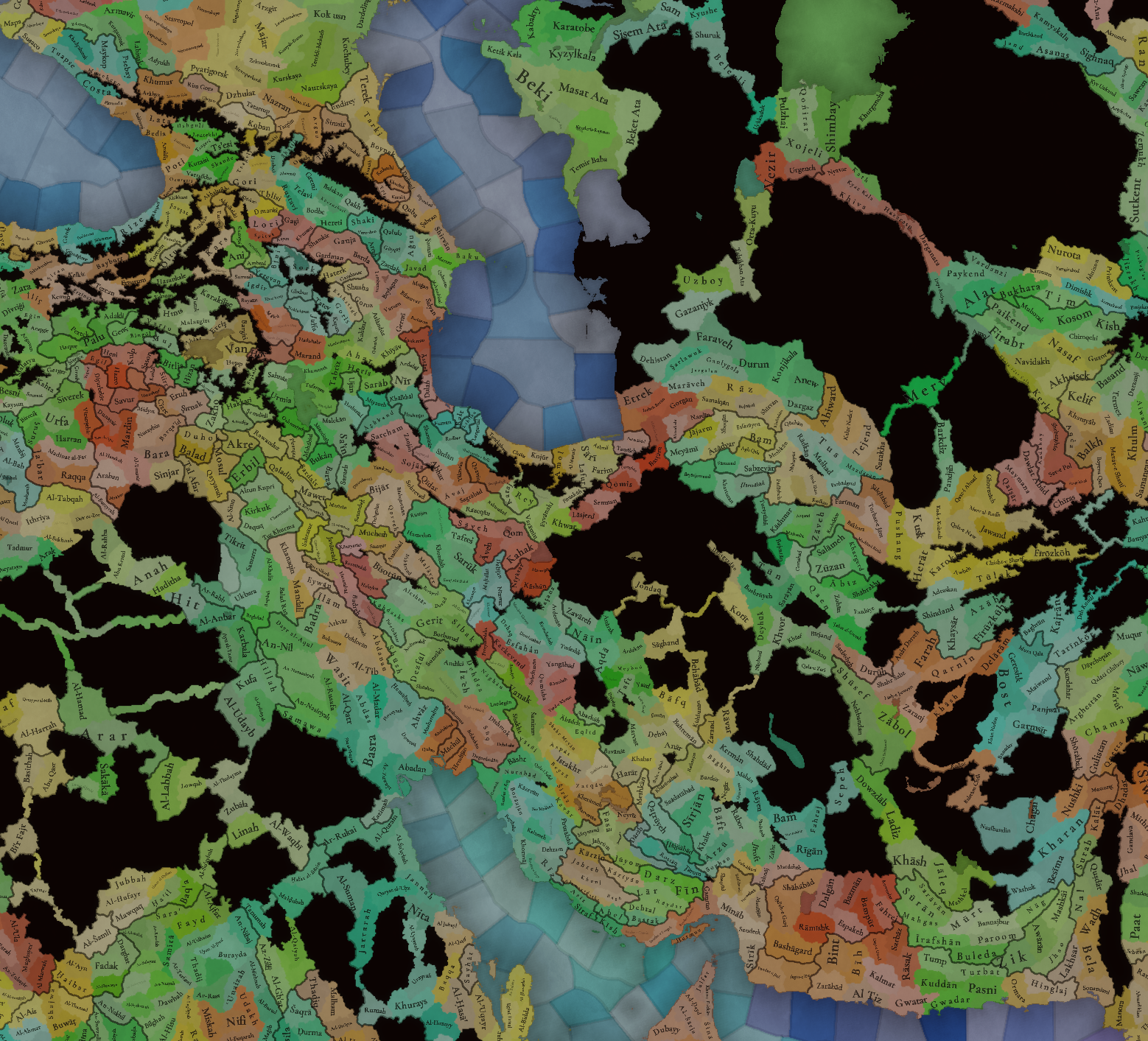
Locations1.png

Locations2.png

Locations3.png

Locations4.png

Locations5.png


Provinces
Provinces.png


Areas
Areas.png


Terrain
Climate.png

Topography.png

Vegetation.png


Development
Development.png


Harbors
Harbors.png


Cultures
Cultures.png


Languages
Language Locations.png

Language Country.png

Language Court.png

The first map is the location language, the second is the common language of each country, and the third one is the court language.

Religions
Religions.png

Now with more minorities!

Raw Materials
Raw Materials.png

Now, with the latest version of raw materials, which you can check here: https://forum.paradoxplaza.com/forum/developer-diary/tinto-talks-54-12th-of-march-2025.1731164/

Markets
Markets.png

Now, with some additions and new coloring changes.

And that's all for today! Remember that this Friday, we will take a look at the content for Persia and the Timurids, which includes the Ilkhanate IO, and the situation The Rise of Timur. And next Monday we will have another Tinto Maps Feedback, this one for the Horn of Africa!
 
  • 62Like
  • 44Love
  • 4
  • 4
Reactions:
Good job! I have some questions and suggestions:

-1-Why do the Jalayrids own Baghdad? In April 1337 the city was the de facto capital of the Hüleguids since that's where Musa Khan retreated after he was defeated in a battle roughly a year earlier, it makes more sense to have Tabriz as the capital of the Jalayrids at game start
-2-I think it's fine to call the language Persian but since the name of the country in game is Iran the region should called Iran as well especially if it contains parts of modern Afghanistan and Pakistan
-3-Rather than just calling the country Iran or Iranian Empire the full name should be "Guarded Domains of Iran" with maybe the name of the ruling dinasty as a prefix(e.g. Ashfarid Guarded Domains of Iran), the name was introduced by the Safavids and was also used as the official name by succeeding dinasties until 1925
-4-Trebizond should be an Empire(tier4 country) at the start so why isn't the tag called Trapezuntine Empire on the map? The rulers had long renounced the claim to the Byzantine throne in the treaty of 1282 and in exchange were recognized with the title of "Emperor and Autocrat of all the East, the Iberians, and the Transmarine Provinces"
-5-Some of the governments should be changed, having steppe hordes in the middle of the region is weird, the Hüleguids, Jalayrids and Gurgan should be settled by 1337 and be a monarchy while some of the minor semi-nomadic clans like the Jurmanids and the Ughanids should be tribes and the same goes for Döger, Āl Faḍl, Al' Ali and Al Mira
-6-The Jurmanids and Ughanids should probably have their scripted dinasty named after their country
-7-Rather than having the in game languages be called Circassian, Georgian and Dagestani it would be nicer to name them after their actual language group of which those three language are part of, Pontic (also North west Caucasian), Kartvelian(also South Caucasian) and Caspian(also NE Caucasian), then maybe separate them into dialects in the future and if you think that the Pontic language could be confused with the hellenic culture then it's better to rename the culture to Pontian
-8-Is there a toll in the strait of Hormuz? I don't know if it historically existed, but since you guys mentioned tolls for the Sound and the Bosphorus a long time ago it would be cool to have a way to create them in some specific straits like Gibralitar and Bab-El-Mandeb...
 
Last edited:
  • 26Like
  • 3
  • 1
Reactions:
Can you change the colour of the Jalayrids please? I was thinking about a blue similar to the one of France since it's not used much in the region, either that or change the colours of countries with similar colour around them like the Injuids, Ahis, Cilicia...
 
Last edited:
  • 2Like
  • 1
Reactions:
Thanks for the post! Though I am slightly disappointed that many of the suggestions I gave were passed over, in this post I will once again point them out to you.

I will repost my suggestion tree from before for your convenience:


1. Political map

1.png
Georgia in the Second and Third Quarters of the 14th C.png

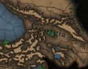
Georgia should control the location of Tuapse on the Abkhazian coast, as it is believed to be the location of the northwesternmost point of Georgia - Nicopsis. Evidently, I wrote this too late for it to have had any meaningful impact in the old thread. In addition, Georgia should directly own Rutul, as can be seen on the map on the right.

Samtskhe shouldn't control the location of Khikhani, and in its place, Georgia should (as the Saeristavo of Adjara, abstracted as an integral part of the country). Side note about Samtskhe - I think it'd be best if its map colour were white, to simulate its proto-national flag/banner more accurately.

"Armenia", the Zakarid dynasty vassal, has an anachronistic name. The dynasty never claimed to represent "Armenia", nor did it ever do so. I suggest changing the name of the country to "Zakarids".

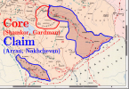
The Duchy of Saarishiano (Shaki) should extend to include all of the province of Shaki (as modelled in-game), as according to the principal historian of the time period, Hamdallah Mustawfi Qazvini, the land was only lost to Shirvan in 1339. I've written more about this in "Georgia map feedback" above.

2. Ilkhanate

2.png


As we've proven many times, Georgia had left the Ilkhanate by 1330. While we do not yet know how the mechanics of this IO will work, I doubt that this map should include Georgia and its subjects in 1337.

3. Dynasties

3.png


The Principality of Alastani is erroneously portrayed as belonging to the Jaqeli dynasty, when in fact it was held by a royal Bagrationi dynast.

Also, why are the colours for the Jaqelis and Bagrationis the same? Are they depicted as a part of the same dynasty, with the former a cadet branch of the latter? Because if so, that's very inaccurate - they are patrilineally unrelated, as far as we know.

4. Country Ranks

4.png


As you portrayed Ethiopia as an empire, I think it would only be fair to do the same for Georgia. The title of the Georgian monarch since 1008 had been "King of Kings", exactly like in Ethiopia. I understand, however, if it is a purely game balance decision.

Shaki should be a Duchy-tier realm as well, as it was a Saeristavo, just like Samtskhe.

5. locations

5 1.png
Location%202.png


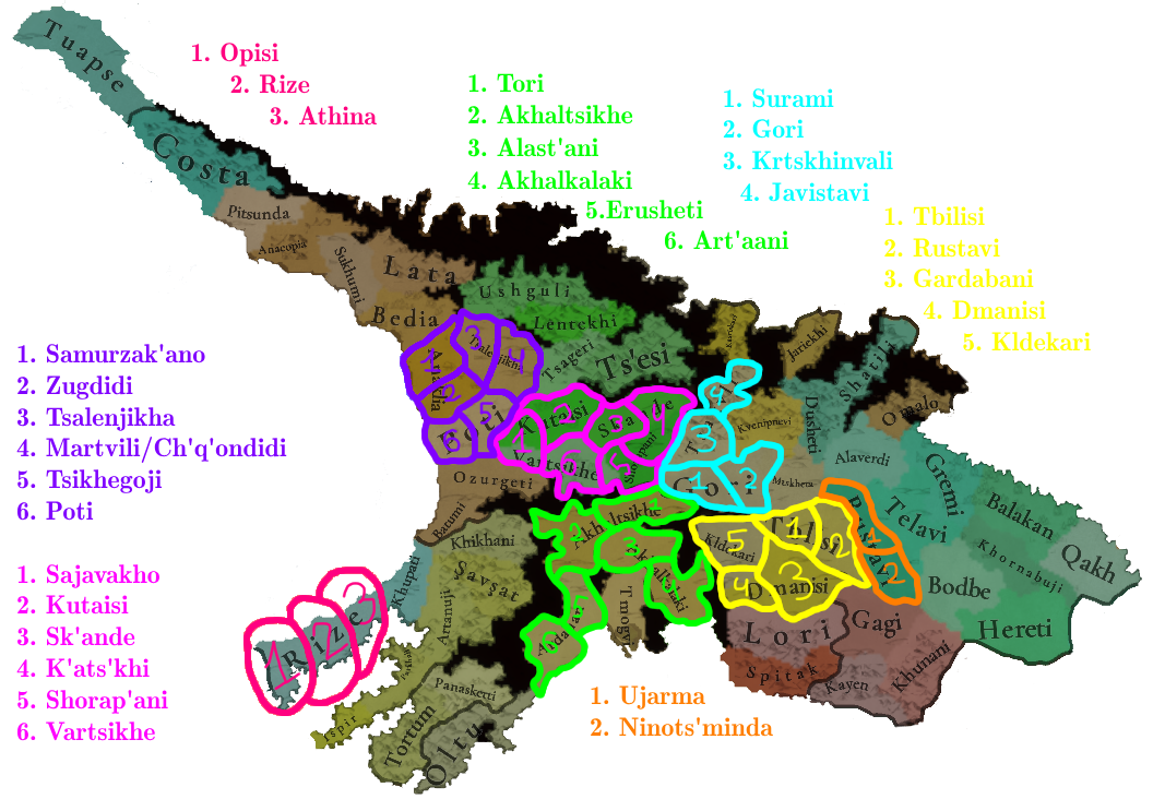
A singular addition of a location to the Georgian region (Şavşat) is very disappointing to see. Especially needed are the further divisions in the Lazeti/Lazona locations of Pontus, and in western Georgia (Imereti).

@Georgian Noble has made a very good map for you to use a guideline. I strongly urge you to rethink your decision in this regard.

Edit: I've made a similar map as well, only including my proposed locations, and if you wish to investigate further yourself, the 2nd map will be of use to you:

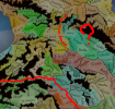
Locations.pngRoads of Georgia in the Middle Ages.png

6. Provinces

6.png


Same as above, it is very disappointing that the oversized province of Imereti still controls Svaneti, and Avaria has "de jure" ownership over Omalo.

In addition, the province names of Samtskhe and Meskheti are very confusing. The regional toponyms of Meskheti and Samtskhe mean the same thing - they are variants of the endonym Meskhi, and represent one and the same region. I strongly recommend changing the name of "Meskheti" to Tao-Klarjeti.

Also, the creation of a "Lazona" province to the east of Trebizond (to represent the Thema of Lazica) would be appreciated.

Tashir should be called "Somkhiti", at least in the Georgian localisation.

Abkhazia should extend to include "Costa" and "Tuapse", though the latter was historically considered to be a part of "Jiketi", so at the very least, include the former in Abkhazia.

Edit: Same as above, I've made a map for my proposed changes to the provinces of the region:

Provinces.png

7. Areas

7.png


I think the province of Tashir should be a part of the Georgian area, as it had been an integral part of Kartvelian statehood for millennia. Plus, it's geographically more tied to Kartli. And same as above, regarding Abkhazia.

Something must be done about "Armenia" and the "Armenian Highlands". As of now, those areas definitely need restructuring.

8. Terrain

8 1.png


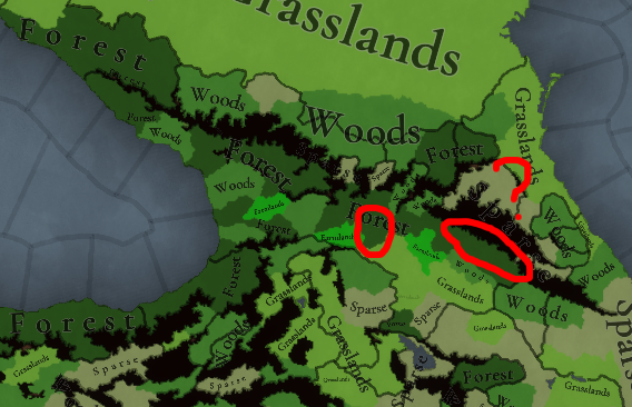
Some of the most agriculturally significant parts of Georgia, Kartli and Kakheti, should be grasslands, or even farmlands. Definitely not forests.

9. Natural harbours

8.png
Georgia Natural Harbours.png


Again, it seems like my suggestions haven't reached you, as I've given numerous sources and info about the quality of the ports of the eastern Black Sea, and yet the natural value of them is still the same as before. I attached an image of the notable (and naturally valuable) harbours of the region. I've written more here.

10. Languages

9 1.png
11 1.png


It is inaccurate to group Georgian, Mingrelian/Laz (AKA Zan), and Svan into the same language. True, they belong to the same language family, but they are NOT mutually intelligible, and haven't been so for 2000 years at minimum. I suggest creating 3 languages in place of them: Georgian, Zan, and Svan, as I've written previously.

Regarding court languages, I think Shaki should have it be Georgian, as it was a Georgian-ruled march since the early 12th century.

And "Dagestanian" (which I presume unites northeastern Caucasian languages) should be spelt "Dagestani".

I've written more here.

11. Cultures

9.png
Avtismvs Maximvs.png

The location of Qakh should be Georgian.

There should definitely be more Laz people in Pontus. It is well-recorded that despite constituting the majority of people in rural areas, Laz people held rather little political power compared to the Pontic Greeks, hence their obscurity. In 1337, they still would've been the majority in the empire. I've attached an image of what I believe to be a fair assessment of the region. You can see my post about this matter here.

Mingrelian should be the majority in Poti, while Georgian should constitute the majority in Ts'esi and "İspir", with Svan and Armenian minorities, respectively. Additionally, there should be a small minority (~15-20%) of Georgians in the city of Ani, as proven by the presence of multiple Georgian churches and inscriptions around the time frame of 1337.

More controversially, I don't think the Abkhaz/Apsua culture should extend that far south. This map (with regard to Abkhazia) more closely represents the situation by the 18th century, after the conquests of Abkhaz chiefs against the Principality of Mingrelia. Thus, I suggest making the current Mingrelian and Svan minorities into majorities in the locations of Sukhumi and Lata, respectively.

I will also once again reiterate that Svans and Abkhaz/Apsua people should be SOPs. As we didn't get an entry for that map mode in this thread, I will presume that this suggestion hasn't yet been implemented. Just FYI.

12. Religion

10.png
updewd9soc.png

The Armenian Apostolic minorities of Georgia are represented well, but the Orthodox Armenian population isn't. In the 12th-13th centuries, a large part of the land held by the Zakarid-Mkhargrdzeli dynasty converted the populace to Eastern Orthodoxy, especially in the Tashir and Ani provinces. "İspir" should be Orthodox as well, along with more locations in Shaki, as that province only became Islamised in the 16th-17th centuries, after mass-scale Qizilbash settlement.

Most importantly, the Georgian pagans of Svaneti and Mtiuleti are not represented at all, which is regrettable. The old pagan beliefs of the mountain regions only really died out in the 19th century. I suggest naming this religion "Kerptaqvanismtsemloba" - "კერპთაყვანისმცემლობა", literally meaning idol worship.

On the top right you can see my map from the previous thread - I hope you can infer the meaning of the colours and hatches without a legend.

There should be small minorities (10-15%) of Catholics in Tbilisi and Tskhumi, as there were Latin Bishoprics there, as I proved in this post.

I've written at length about the cultural and religious demography of Georgia here.

13. Raw materials

11.png


Again, it unfortunately seems like my feedback wasn't received at all, as many of the raw goods which I pointed out to be incorrect are still in place, most notably wheat in Kutaisi, though the silk in Gremi is very nice to see. I suggest taking a look at my extensive suggestions here.

14. Markets

12.png


Very pleased to see a Tbilisi market. Perhaps it should have greater control to the south, over the Armenian subjects of Georgia?


Overall, admittedly, I am quite disappointed with these changes. I truly don't want to sound demanding, but I feel as though this feedback post was rushed, at least for the region I can speak for. Sorry to @Pavía if this sounds too demanding or rude.
 
Last edited:
  • 32Like
  • 8Love
  • 8
  • 3Haha
  • 1
Reactions:
Trebizond was an empire, Ormus and the Hüleguids should be kingdom rank titles, most of the indipendent turkik bayliks should be duchy rank same for the Jarwanids and Usfurids(if they are added) as they used the title of Amir, I'm pretty sure that other rulers in the region like the Injuids, Muzaffarids and so on used the title of Emir but I don't know for sure.
Shirvan was ruled by a Shah amd considering they are part of the Ilkhanate they should be either a kingdom or a duchy if you nake them vassals of the Jalayirids
 
Last edited:
  • 8Like
  • 2
  • 1
Reactions:
Are the specks of color showing inside big wastelands in the location maps, such as the ones below, just pixel errors in the bmp, are they display errors in the game, are they intentional, are they lakes that get colored in for some reason? What's going on there?
1743426578502.png
1743426637036.png

Edit: Nevermind, they are clearly lakes, there's just something weird that happens in the location map.
 
  • 1Like
Reactions:
I like the new colour for the othodox religion but now it's too similar too miyaphisite so maybe make it into a dark shade of red, the bogomilist and paulician heresies in the balkans should heve their colour changed too and same for those two purpleish pagan religions in the Caucasus
 
Last edited:
  • 5Like
  • 1
Reactions:


1000011336.jpg


Now let's see here...

Gonna have a more thorough look later. Some stuff to fix here and there, but looking mostly good.


Old Community Feedback map compared to the Review map:
(Gonna make a new map later to make the feedback process easier)

1743427990250.png
1743429617313.png


Old locations, but there weren't many changes:

1743428023008.png


Last edited:
  • 8Like
  • 3Haha
  • 1
Reactions:
Can you fuse the Armenian highlands region with Armenia and give an english name to regions like Iraq and Khorsan since there different people speaking different languages in thise regions
 
  • 5Like
  • 3
Reactions: