• We have updated our Community Code of Conduct. Please read through the new rules for the forum that are an integral part of Paradox Interactive’s User Agreement.
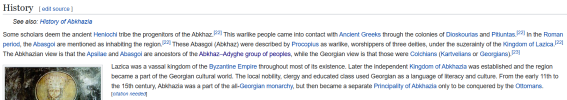
sorry bro first statement is completly irrelevant and that circassians were using georgian and greek writing doen not change anything and still even so you can not find inscriptions written in georgian, greek or arabic scripts in circassian language in abkhazia.(arabic was also common in georgia because of muslim conquest and arab influence in georgia as consequence)

second argument is misleading because you might think that abkhazian inhabitants were using georgian script because they themselves did not had any to use but truth is they were using georgian because they themselves were georgians and they spoke georgian language(as i said historical abkhazians and modern abkhazians are two different people) also it proves my point because in early medieval times kingdome of abkhazia and later principality of abkhazia were independent states but they kept using georgian language for some reason? why would they if they had their language?(if you look at it even wikipedia says georgia was used language in the kingdom even greek and arabic but not a word about abkhazian).

as i said there is no evidence that they spoke any other language than Georgian


View attachment 1332299
signature of Giorgi Sharvashidze, prince of abkhazia
1752195812327.png

I read your article, the arguments are just assumptions and assertions that don't necessarily follow from the evidence presented. Written language is often different from spoken language. Medieval England wrote in French.
 

Attachments

  • 1752195717098.png
    1752195717098.png
    174,3 KB · Views: 0
  • 1
Reactions:
I agree with @JaddesBarro in that the "Abkhazian" culture (which, like I argued, should be renamed to Apsua), should also belong in the Georgian (or Kartvelian) culture group, due to the multitude of factors stated by them above, while remaining in the "Circassian" language group, as it likely represents the Northwest Caucasian languages with a more flavourful name. This can be compared to Manx being in both Gaelic and Scandinavian culture groups.

Like I said in my big post on the first page, the Mingrelian and Svan cultures should be present in the locations of Bedia, Tskhumi (still not renamed from Sukhumi as per the Steppes feedback) and in Lata, respectively.

Please, Paradox. Georgian members of this community have clearly shown discontent regarding the representation of this region. I hope you understand the importance of an accurate depiction of Abkhazia and handle it with care, like you did with Moldavia.

Thank you.

pls.jpg
 
  • 6
  • 4
Reactions:
A few more suggestions:
Buinaksk could be split into two provinces — the city of Buinaksk itself and a coastal province named either Ötemysh (Utamysh) or Kayakent (Gamri). According to some sources, this province was at different times controlled by both the Kaytag Utsmis and the Shamkhals.
I would also like to suggest dynamic province names for the Lezgian culture:
Derbent – possible names include Kvevar, Ts’al, or Rak’un varar
Quba – Kʼele
Niyazabad – Müşkür
Baku – Boggus (in Khinalug), Getara or Pakul (in Lezgian)
Barda – Partav
Shamaki – Mamechia
Gabala – Kvepele
Also, Niyazabad and Derbent are both referred to as Albana in one source.
At the moment, this is all I’ve been able to gather.
I'm currently working on names for estates as well, though my limited knowledge of the language is making it more difficult.
IMG_20250711_143634_706.jpg
 
  • 4Like
Reactions:
View attachment 1332332
I read your article, the arguments are just assumptions and assertions that don't necessarily follow from the evidence presented. Written language is often different from spoken language. Medieval England wrote in French.
here lets look at the map

Melchisédech_Thévenot._Carte_de_la_Colchide_appelée_maintenant_Mengrelie,_et_par_ceux_du_pays,...jpg

Carte de la Colchide appelée maintenant Mengrelie, 1660​


this is map shows north-west part of georgia todays samegrelo and abkhazia parts as you can clearly see this map contains cities like, zugdidi in todays samegrelo(migrelia), and in abkhazian parts ilori(near ochamcire), bedia, anaklia, tkvarcheli.

Based on the translation of the map title, it refers to the region as "Mengrelie" (Mingrelia) and states it's called "Odisci" by "ceux du pays" (those of the country). the fact that it names the region "Mengrelie" and uses the local term "Odisci" strongly implies that the people inhabiting the area were migrelians.

The map includes, in its top-left information block, the phrase 'Abbachi hodie Abassia', which translates to 'Abkhazia today Abassia'. This identifies a region or people and is depicted on the map in the northern part of the mountain range. This suggests the presence of people of abassia is in current Circassian territory, rather than within the modern borders of Abkhazia.

Crucially, the map distinctly labels a significant defensive structure with the text: 'Muraille de Soixante milles pour arrester les Incursions des Abbassas', which translates to 'Wall of Sixty miles to stop the Incursions of the Abbassas'. This explicitly indicates a major wall built to defend against incursions specifically from a group identified as 'Abbassas'(todays "abkhazians" or apsua as they call themselves).

This cartographic evidence, including the depiction of 'Abbachi hodie Abassia' in the northern mountains and the presence of a substantial defensive wall explicitly designed to counter 'Abbassas' incursions, strongly supports the argument that the people current Abkhazians may not have inhabited area Abkhazia at the time this map was created. that also proves supports my point that they migrated on this land way after 14th century(in 16th-18th centuries). so depicted abkhazian as majority culture in akhazian region is wrong, because as we can see from this map todays abkhazian region more than half of its territory wast majoirty of population were migrelians as map says.

Also, the earliest written records of the Abkhaz language were recorded by Evliya Çelebi in the
17th century. As I've said, any evidence of the Circassian or Abkhazian language wasn't found on Abkhazian land, not only throughout the Middle Ages but until the 19th century. So, why would you claim that the spoken language in Abkhazia in the 14th century was not Mingrelian but Abkhazian (or Circassian, as shown in the game)? Therefore, it also means the Circassian language in the Abkhazian region as shown in the game is incorrect.
 
  • 4Like
Reactions:
here lets look at the map

View attachment 1332603

Carte de la Colchide appelée maintenant Mengrelie, 1660​


this is map shows north-west part of georgia todays samegrelo and abkhazia parts as you can clearly see this map contains cities like, zugdidi in todays samegrelo(migrelia), and in abkhazian parts ilori(near ochamcire), bedia, anaklia, tkvarcheli.

Based on the translation of the map title, it refers to the region as "Mengrelie" (Mingrelia) and states it's called "Odisci" by "ceux du pays" (those of the country). the fact that it names the region "Mengrelie" and uses the local term "Odisci" strongly implies that the people inhabiting the area were migrelians.
If you have to say 'it strongly implies' it doesn't strongly imply. It is very very plausible that some place names were not Abkhazian because other people lived there because ethnostates weren't a thing for centuries. There's evidence the ruling class and intelligentsia used Georgian which is common in countless minority cultures across the globe and is completely normal and commonplace. Odishi is a regional name equivalent to Mingrelia. You can have a region called Mingrelia and have people there who are not Mingrelians. There's a place called England and there's Cornish people there. There's a place called France yet there's Bretons living there. There's a place called Japan yet there's Ainu living there. On and on and on and on.
The map includes, in its top-left information block, the phrase 'Abbachi hodie Abassia', which translates to 'Abkhazia today Abassia'. This identifies a region or people and is depicted on the map in the northern part of the mountain range. This suggests the presence of people of abassia is in current Circassian territory, rather than within the modern borders of Abkhazia.
People can be in two different places at the same time. Also, the Abaza are a separate, related group. The fact that the two areas have very similar names is a sign that related peoples lived there, the evidence is clearly not decisive. The Circassians also have a similar name for themselves (adyge) and are also related to both the Abaza and the Abkhazians. We're talking about many different tribes here that all lived in different places at different times. Perfectly plausible, happens all the time.
Crucially, the map distinctly labels a significant defensive structure with the text: 'Muraille de Soixante milles pour arrester les Incursions des Abbassas', which translates to 'Wall of Sixty miles to stop the Incursions of the Abbassas'. This explicitly indicates a major wall built to defend against incursions specifically from a group identified as 'Abbassas'(todays "abkhazians" or apsua as they call themselves).
You're assuming that all these names without any doubt whatsoever refer to the exact same group of people (when a simple google search shows otherwise) and those people only ever lived in one tiny area and couldn't possibly be anywhere else at any other point in history. Have you considered the possibility that there were Georgians and Abkhazians in Abkhazia in varying amounts at different times, considering they're neighbors?
This cartographic evidence, including the depiction of 'Abbachi hodie Abassia' in the northern mountains and the presence of a substantial defensive wall explicitly designed to counter 'Abbassas' incursions, strongly supports the argument that the people current Abkhazians may not have inhabited area Abkhazia at the time this map was created. that also proves supports my point that they migrated on this land way after 14th century(in 16th-18th centuries). so depicted abkhazian as majority culture in akhazian region is wrong, because as we can see from this map todays abkhazian region more than half of its territory wast majoirty of population were migrelians as map says.
May not? Sure, why not? Yet you talk like this is obvious and guilt tripping the devs because they're so horrible for not completely erasing a deeply politicized minority group. My issue is with you acting like the devs are irrational for 'not listening to the Georgian community.' This topic is clearly disputed. Your evidence is far from solid. It's ambiguous and the devs should side with caution and reason, not ethnic politics.
Also, the earliest written records of the Abkhaz language were recorded by Evliya Çelebi in the 17th century. As I've said, any evidence of the Circassian or Abkhazian language wasn't found on Abkhazian land, not only throughout the Middle Ages but until the 19th century. So, why would you claim that the spoken language in Abkhazia in the 14th century was not Mingrelian but Abkhazian (or Circassian, as shown in the game)? Therefore, it also means the Circassian language in the Abkhazian region as shown in the game is incorrect.
Completely ignoring and pretending as if I didn't point out that written and spoken language are different. By that logic, the vast majority of the 10,000 languages that exist today did not exist until the cold war. There's no written evidence of them anywhere! Absence of evidence is not evidence of absence.
 
  • 2Like
Reactions:
If you have to say 'it strongly implies' it doesn't strongly imply. It is very very plausible that some place names were not Abkhazian because other people lived there because ethnostates weren't a thing for centuries. There's evidence the ruling class and intelligentsia used Georgian which is common in countless minority cultures across the globe and is completely normal and commonplace. Odishi is a regional name equivalent to Mingrelia. You can have a region called Mingrelia and have people there who are not Mingrelians. There's a place called England and there's Cornish people there. There's a place called France yet there's Bretons living there. There's a place called Japan yet there's Ainu living there. On and on and on and on.
Yes, that's totally true. But a place is commonly named after the people who live there, or vice versa; especially its true for georgia, those lands were called Mingrelia by cartographers because they were mainly populated by them. same with minorities Bretons have Brittany, Cornish folk have Conrwall, Welsh have Wales, and it would be same case with this land

People can be in two different places at the same time. Also, the Abaza are a separate, related group. The fact that the two areas have very similar names is a sign that related peoples lived there, the evidence is clearly not decisive. The Circassians also have a similar name for themselves (adyge) and are also related to both the Abaza and the Abkhazians. We're talking about many different tribes here that all lived in different places at different times. Perfectly plausible, happens all the time.
You're assuming that all these names without any doubt whatsoever refer to the exact same group of people (when a simple google search shows otherwise) and those people only ever lived in one tiny area and couldn't possibly be anywhere else at any other point in history. Have you considered the possibility that there were Georgians and Abkhazians in Abkhazia in varying amounts at different times, considering they're neighbors?
Well, no, 'Abassas' refers to Abkhazians in this case, not Abaza, as I will show you with the same name on different maps.

map.png

Carte de Perse dressee pour l'usage du Roy, 1724

Nova_et_Accurata_Tartariae_Europae_seu_Minoris_et_in_specie_Crimeae,_Matthaus_Seutter_(Augsbur...jpg

Nova et Accurata Tartariae Europae seu Minoris et in specie Crimeae, Matthaus Seutter (Augsburg, 1740)​


La_Russie_Blanche_ou_Moscovie_[...]Sanson_Guillaume_btv1b531192604.jpg

La Russie Blanche ou Moscovie, 1709

As you can see, after 50 years, Abassa is now located in modern Abkhazia, in its northern parts. They migrated there, as shown on these maps.

"Have you considered the possibility that there were Georgians and Abkhazians in Abkhazia in varying amounts at different times, considering they're neighbors?"

Well, they literally have, because they migrated.

Yet you talk like this is obvious and guilt tripping the devs because they're so horrible for not completely erasing a deeply politicized minority group. My issue is with you acting like the devs are irrational for 'not listening to the Georgian community.'
No
Absence of evidence is not evidence of absence.
I think it's irrelevant. because you could claim anything and assert it's completely true until someone proves it wrong. However, it's actually the opposite: if you claim something, you should prove it. Why do you think Apsua were living in Abkhazia(in ) in the 14th century when you have no evidence of that?

also you can check this document on apsua and abkhazia
 
  • 4Like
  • 2
Reactions:
Yes, that's totally true. But a place is commonly named after the people who live there, or vice versa; especially its true for georgia, those lands were called Mingrelia by cartographers because they were mainly populated by them. same with minorities Bretons have Brittany, Cornish folk have Conrwall, Welsh have Wales, and it would be same case with this land
Feel free to go through this list and explain how every last group here has their own named landmass and it's physically impossible for a group to live an area named after a different group. This is such a loose vibes based argument. An area can have multiple groups at the same time.
Well, no, 'Abassas' refers to Abkhazians in this case, not Abaza, as I will show you with the same name on different maps.

View attachment 1332712
Carte de Perse dressee pour l'usage du Roy, 1724

View attachment 1332713

Nova et Accurata Tartariae Europae seu Minoris et in specie Crimeae, Matthaus Seutter (Augsburg, 1740)​


View attachment 1332714
La Russie Blanche ou Moscovie, 1709

As you can see, after 50 years, Abassa is now located in modern Abkhazia, in its northern parts. They migrated there, as shown on these maps.
Yes they're very similar names, these things happen all the time. Georgia, Armenia all these names were located in different places on different maps. Of course, Abkhazians, Circassians and Abaza all get mixed up their endonyms are all the same. Maps are not the silver bullet you think they are, they're often horrendous and terrible and misleading. Do you think Tataria is a real country too?
Well, they literally have, because they migrated.
Of which you've provided zero evidence of a total rapid population turnover. Just claiming a bunch of names are the same as other names without any evidence from the time period that these names are actually the same.
No

I think it's irrelevant. because you could claim anything and assert it's completely true until someone proves it wrong. However, it's actually the opposite: if you claim something, you should prove it. Why do you think Apsua were living in Abkhazia(in ) in the 14th century when you have no evidence of that?
Didn't read what I said. I literally, explicitly, as clearly as humanly possible said. It. Is. Ambiguous. The evidence is they're there right now and we've no evidence of them not being there beyond you showing maps of countries and conflating them with ethnic groups as if Georgia was an ahistorical ethnostate. Clearly the academic consensus in impartial countries is that the Abkhazians are at least partially indigenous.
also you can check this document on apsua and abkhazia
'Trust me bro. This name means this, I'll assert it twenty times, then it'll be true.' I already told you I read your article. All it does is constantly conflate political control with ethnic composition and claim a bunch of names mean this or that without providing any evidence that people in ancient times actually thought that. It also conflates the idea that 'Georgian culture was dominant, many Georgians lived there and Abkhazia was apart of the Georgian culture sphere' (which is clear, reasonable and well known) with the claim 'there were zero ethnic Abkhazians there.' Again, the English were a nation of millions of people, yet still used French for centuries. In China there are countless ethnic groups but most of them ended up using Chinese. These things happen sometimes.

Do you have written texts explicitly detailing the ethnic composition of Abkhazia and claiming not a single northwest caucasian speaking group to be found? Is there a massive and unrealistic archaeological difference between Abkhazia and Circassia, following the Abkhazian border, where there are strictly only Kartvelian things on one side and Caucasian on the other for 2000 years until your migration? Is there archaeological evidence of a massive population turnover? Massacres? Battles? Are there loan words, historical records of this massive migration (not implications or assumptions, clear and explicit descriptions of a migration), anything? Georgian history is not some black hole. If there was a massive migration, there'd be records of it, we'd see it everywhere. You wouldn't need to play name games.
 
Last edited:
  • 3
  • 1Like
Reactions:
Feel free to go through this list and explain how every last group here has their own named landmass and it's physically impossible for a group to live an area named after a different group. This is such a loose vibes based argument. An area can have multiple groups at the same time.
I literally said it's just a common thing, especially in Georgia, where almost every region is named after the people who live there, or vice versa. History is full of examples of regions of multiple ethnic groups living side-by-side in areas with names that reflect or describes only major population or region.
Yes they're very similar names, these things happen all the time. Georgia, Armenia all these names were located in different places on different maps. Of course, Abkhazians, Circassians and Abaza all get mixed up their endonyms are all the same. Maps are not the silver bullet you think they are, they're often horrendous and terrible and misleading. Do you think Tataria is a real country too?
Historical maps, shifting broaders for entities like Georgia and Armenia or other states is i belive a natural cause or just margin of error, regions of Abassa and Migrelia have somewhat consistent borders on those maps. The recurring placement of "Dardars" along the border of Abassa supports the argument for the maps' relative accuracy within their historical context. This consistency suggests a degree of accuracy in their depiction of these specific areas. Furthermore, the distinct representation of Circassians on these maps, separate from Abkhazians, indicates that the cartographers of the period did not conflate these two groups.so your claim that they mixed up Circassians and Abkhazians on these maps is not case in here,

Regarding the nomenclature, the consistent use of Abassa across maps is written in French (and one in Latin, a related language) suggests that this naming convention was likely a standard of the region's name during that period in their language, rather than a consequence as you claimed. So you can call those maps accurate.


maps.png
Carte_de_Perse_dressйe_pour_[...]Delisle_Guillaume_btv1b5973030n_1.jpg


Of which you've provided zero evidence of a total rapid population turnover. Just claiming a bunch of names are the same as other names without any evidence from the time period that these names are actually the same.
well it never was rapid nor turnover even in first population census in 1886 abkhazians were minority in the region as somwhere 40% of total population
census.png


Brou the fact that they have sea-related words does not prove that a people are indigenous(poor Uzbeks are double landlocked but they also have sea-related words). And what do you mean by partially indigenous? that they are living there for 2 centuries? 4 or maybe 6? Sure, why not. I think it would be enough to make up or borrow some sea-related words. And why are you relating to wiki as academic source bro?

Is there a massive and unrealistic archaeological difference between Abkhazia and Circassia, following the Abkhazian border, where there are strictly only Kartvelian things on one side and Caucasian on the other for 2000 years until your migration?
There cannot be massive or unrealistic archaeological differences between Abkhazia and Circassia because they are in the same region; there are difference but not massive. also, there is no archaeological difference between Abkhazia and Mingrelia in ancient or medieval times at all, which is interesting considering that Abkhazians have their own distinct religion, culture, and language. One might expect to see archaeological evidence of these distinctions if they were the majority population in Abkhazia during those periods.

Is there archaeological evidence of a massive population turnover? Massacres? Battles? Are there loan words, historical records of this massive migration (not implications or assumptions, clear and explicit descriptions of a migration), anything? Georgian history is not some black hole. If there was a massive migration, there'd be records of it, we'd see it everywhere. You wouldn't need to play name games.
No, it wasn't a sudden, massive migration like those seen, for example, during the fall of the Roman Empire. Instead, the demographic changes in Georgia occurred slowly and naturally over centuries. This gradual evolution meant there wasn't widespread turmoil, massacres, or battles directly attributable to a single, overwhelming population influx.
 
Last edited:
  • 3Like
Reactions:
Yeah you're repeatedly just not engaging with my points or engaging selectively. Purposely going after the sea thing, which even the author says is dumb, ignoring everything else. Ignoring that wikipedia articles cite sources which provide a neutral perspective. Never claimed Abkhazians were a majority or that there were no Georgians. Never claimed they mixed up Circassians and Abkhazians specifically. You've still cited no primary sources besides name changes on maps. Ignoring that the Abaza are a living ethnic group today that don't live in Abkhazia. Playing with the word indigenous even though I know you know what I actually meant. Not engaging with it being well known that the Abkhazians were a part of the Georgian culture sphere often ruled by Georgians (your own source says so), so would be archaeologically similar and that ethnic groups often adopt the customs and materials of prestige cultures, which medieval Georgia absolutely was (Hail Queen Tamar). Not a single thing you're saying precludes the possibility that there were significant northwest caucasian groups living in Abkhazia, nor does it debunk the perspectives of most nonethnonationalist scholars that the Abkhazians are at least partially indigenous to the area and aren't foreign invaders. Unless you provide conclusive evidence and not implications, I'm done replying, my points been made. Abkhazians shouldn't be completely removed.
I literally said it's just a common thing, especially in Georgia, where almost every region is named after the people who live there, or vice versa. History is full of examples of regions of multiple ethnic groups living side-by-side in areas with names that reflect or describes only major population or region.

Historical maps, shifting broaders for entities like Georgia and Armenia or other states is i belive a natural cause or just margin of error, regions of Abassa and Migrelia have somewhat consistent borders on those maps. The recurring placement of "Dardars" along the border of Abassa supports the argument for the maps' relative accuracy within their historical context. This consistency suggests a degree of accuracy in their depiction of these specific areas. Furthermore, the distinct representation of Circassians on these maps, separate from Abkhazians, indicates that the cartographers of the period did not conflate these two groups.so your claim that they mixed up Circassians and Abkhazians on these maps is not case in here,

Regarding the nomenclature, the consistent use of Abassa across maps is written in French (and one in Latin, a related language) suggests that this naming convention was likely a standard of the region's name during that period in their language, rather than a consequence as you claimed. So you can call those maps accurate.


View attachment 1332768View attachment 1332769


well it never was rapid nor turnover even in first population census in 1886 abkhazians were minority in the region as somwhere 40% of total population
View attachment 1332772


Brou the fact that they have sea-related words does not prove that a people are indigenous(poor Uzbeks are double landlocked but they also have sea-related words). And what do you mean by partially indigenous? that they are living there for 2 centuries? 4 or maybe 6? Sure, why not. I think it would be enough to make up or borrow some sea-related words. And why are you relating to wiki as academic source bro?


There cannot be massive or unrealistic archaeological differences between Abkhazia and Circassia because they are in the same region; there are difference but not massive. also, there is no archaeological difference between Abkhazia and Mingrelia in ancient or medieval times at all, which is interesting considering that Abkhazians have their own distinct religion, culture, and language. One might expect to see archaeological evidence of these distinctions if they were the majority population in Abkhazia during those periods.


No, it wasn't a sudden, massive migration like those seen, for example, during the fall of the Roman Empire. Instead, the demographic changes in Georgia occurred slowly and naturally over centuries. This gradual evolution meant there wasn't widespread turmoil, massacres, or battles directly attributable to a single, overwhelming population influx.
 
Last edited:
  • 3
  • 2Like
Reactions:
according to official Sokhumi site old Apsua tribes called their capital Acua, Greeks - Dioscuria and Romans - Sebastopolis. you can find Sokhumi on the maps that I provided mentioned as, Sebastopolis, Sokhumi or even as Ckhumi which is Migrelian naming of the city, but you can not find Sokhumi mentioned as Acua nor on the maps that I provided nor on the other maps. Interenstingly you can find Acua on maps but in north Caucasus region.

acua2.png


acua.png


You've still cited no primary sources besides name changes on maps. Ignoring that the Abaza are a living ethnic group today that don't live in Abkhazia.
Yes, but name Abassa clearly points to modern abkhazian regions north parts. and @Machabeli provided writing sources in this post.

Not a single thing you're saying precludes the possibility that there were significant northwest caucasian groups living in Abkhazia, nor does it debunk the perspectives of most nonethnonationalist scholars that the Abkhazians are at least partially indigenous to the area and aren't foreign invaders. Unless you provide conclusive evidence and not implications, I'm done replying, my points been made. Abkhazians shouldn't be completely removed.
Sure, then lets do what @Machabeli and @GenericUsername1444 are saying, make central Abkhazian parts(Sokhumi region) Migrelian culture majoirty, and keep northern parts Abkhazian culture which was always like that, starting from first population census, Apsua were majoirty in northen parts of Abkhazia(and if they were living there at the time I think it would be same).
 
  • 3Like
Reactions:
Religio Rusticum.png


Based on this map in the latest TT, it seems like eastern Hereti/western Shirvan still continues to be mostly Muslim. I believe this is inaccurate for the time period of 1337.

Like I've said previously, this region was majority Orthodox Christian up until Shah Abbas' conquests in the early 17th century, where hundreds of thousands of Christians were slaughtered or deported deep into Iran, while Shia Qizilbashes were settled in their place, Turkifying the region in a short amount of time.

Therefore, I suggest making the locations of Vartashen, Aresh, Qəbələ and Göyçay majority Orthodox, with the rest of the province of Shaki plurality Sunni Muslim.

Shirvan.png


On the topic of Shirvan, I was wondering whether making the capital of the country, Shamakhi, majority Christian would be historical or not. According to the well-sourced Wikipedia page on the city, both western and eastern travellers attest to the city being predominately Christian even into the late 16th century. I can't speak of the veracity of those comments, but I thought it would be prudent to leave this link here for the consideration of the developers.

Thank you.
 
Last edited:
  • 5Like
  • 2
  • 1
Reactions:
With the video showcasing Europe's terrain development dropping yesterday, I thought it would be relevent if I were to give minute feedback regarding the looks of the south Caucasus region, using the picture taken from TF #22 as reference, as it seems to be almost unchanged from its most recent iteration shown in the video, save for the snow on the mountain chain.


Georgia.jpg


Kakheti

Eastern Georgia was historically a very significant region in terms of agricultural output and continues to be so today. Seeing such dense foliage in the locations of Gremi, Belakani, and K'aki is very jarring. The farmlands in this province as seen today wasn't the product of later deforestation and would in fact be contemporaneous with the pre-Black Death Georgia.

Thus, I suggest at least changing the vegetation of these locations at the very least from forest to woods, if not grasslands or even farmlands, though the lattermost suggestion is obviously a balance question.

Kakheti-Hereti.pngKakheti-Hereti EU5.png

Kartli

Kartli, the capital region of the Georgian kingdom, should be much less forested, especially in the locations of Mtskheta and Kvenipnevi. I fully understand that the current location density of the province doesn't allow for much detail, so I will reiterate that my proposed locations could be added to better represent the diversity of topography of the province.

Additionally, Tbilisi should be farmlands—as a typical medieval city with an inner and outer part, the latter of which sat upon well-irrigated lands provided by the Mtkvari river.

Kartli.pngKartli EU5.png

Thank you.
 
  • 5Like
Reactions:
Continuing my last post, I would like to discuss western Georgia, more specifically the absence of the river Rioni (Gr. Phasis) on the map.

Historically, this river was considered to be navigable both in antiquity and the entirety of the middle ages - up to and including the early modern period.

It was significant in the agricultural and mercantile life of western Georgia, to quote the Historical Atlas of Georgia:

"As a consequence of Greek colonization, the Rioni and Mt'k'vari highways were integrated into regional and Eurasian trade (Strabo Il.1.15, XI.7 .3; Pliny Nat. hist. VI.52; Anon. PPE 9v9-10). A particularly important site along the caravan road was Shorap'ani (Sarapanis). Strabo counted four days from Shorap'ani to the Kyros (Mt'k'vari) river (XI.2.17, 3.4), and Varro, followed by Pliny, reports a five-day journey from the Cyrus/Kyros river to Phasis (Poti) (Nat. hist. Vl.52)."

"From the main ports, large and small boats sailed up the
Ch'orokhi, Rioni and its tributaries (Q'virila, Tskhenists'q'ali, Tekhura), Khobi, Enguri, and Ghalidzga rivers. The most important river route was that of the Rioni. Strabo mentioned that the Phasis was navigable up to Sarapana (Shorap'ani) (XI.2.17). Pliny added that "the Phasis ... is navigable for ships of any size for 38.5 miles, and a long way further for smaller vessels" (Nat. hist. VI.13). A map compiled in 1737 in the kingdom of Imereti for Russian authorities specified that from Poti to the junction of the Rioni and Tskhenists'q'ali the river is usable for sailing vessels with cannons; from here up to Kutaisi for small galleys, and from Vardtsikhe until Shorop'ani for small river boats (Beradze 1989: 244-45). The river route from Kutaisi to Poti took two days, while the same distance could be covered in a day by a land road (Ievlev: 141). Intensive navigation of the Rioni lasted until 1769. Bishop Maksime, the ambassador of the king of Imereti to Russia, reported that traders went downstream and upstream the Rioni to and from the east Black Sea ports: Batumi, Poti and Sokhumi (Mach'aradze ,Masalebi: 300-01, 304). After the Russian-Turkish War in the 1770s, navigation on the Rioni practically came to an end."

2.png

(While I realise that rivers will not be navigable in EU5 on launch, this is still proof of the its significance).

@SaintDaveUK gave a comment regarding the depiction of rivers in EU5:

1.png


While we don't know what these criteria for admission in-game are, I believe I have demonstrated why this river in particular deserves to be represented in-game, despite its relatively diminutive size.

Thank you.
 
  • 2Like
Reactions: