• We have updated our Community Code of Conduct. Please read through the new rules for the forum that are an integral part of Paradox Interactive’s User Agreement.

Pavía

Content Design Lead PDX Tinto
Paradox Staff
12 Badges
Jan 3, 2006
3.551
146.275
  • Crusader Kings II
  • Europa Universalis III Complete
  • Europa Universalis IV
  • Heir to the Throne
  • Europa Universalis III Complete
  • Europa Universalis III Complete
  • 500k Club
  • Europa Universalis IV: El Dorado
  • Europa Universalis IV: Cradle of Civilization
  • Crusader Kings II: Jade Dragon
  • Stellaris: Distant Stars
  • Stellaris: Ancient Relics
Hello, and welcome one more week to another Tinto Maps Feedback post! Today, we will be reviewing the region of the Steppes, before tomorrow's look at the Golden Horde and Horde-related content in Tinto Flavour. Let's start with the list of changes, as usual:

ADDITIONS

Added the following:
  • Locations (13)
    • Adalaga
    • Chuhuiv
    • Hovtva
    • Kolomak
    • Lutava
    • Opishnya
    • Perekop
    • Solkhat
    • Ternivka
    • Vilshana
    • Yahotyn
    • Yaroslavka
    • Zmiiv
  • Provinces
    • Donetsk
    • Nizhyn
  • Areas
    • Kursk
  • Religions
    • Čimarii Jüla (mari_paganism)
    • Inmarism (udmurt_paganism)
    • Važesköm (komi_paganism)
    • Samoyedic Shamanism (samoyedic_paganism)
  • Dynamic Names
    • Added some Dynamic Names
CORRECTIONS

Renamed the following:
  • Locations (only corrections. Additionally renamed all location to standardized form):
    • Ak-Mechet to Aqmecit
    • Aqmescit to Qarasuvbazar
    • Berezivka to Aqmecit
    • Brovary to Desnyanskyi Horodok
    • Chaplynka to Qalançaq
    • Chervonyi Mayak to Tavan
    • Henichesk to Enice
    • Holyi Pereviz to Ordu Bazar
    • Hornostaivka to Rohat Kermen
    • Kherson to Oleshia
    • Lykhivka to Myshuryn Rih
    • Nova Odesa to Argamakli Sarai
    • Ochakov to Dashev
    • Orzhytsya to Horoshino
    • Primorsko-Akhtarsk to Akhtar
    • Pyatigorsk to Yessentuq
    • Ripky to Liubech
    • Romny to Romen
    • Shevelivka to Vovchansk
    • Starogorodskaya to Oster
    • Unenezh to Nizhyn
    • Vasylivka to Kinskie
    • Velyka Bilozerka to Kuchugur
    • Veselynove to Balikley
    • Voznesensk to Sokolyts
  • Provinces - only corrections. Additionally, renamed all of them to a standardized form:
    • Chaplynka to Qalançaq
    • Kalay to Or Qapi
    • Kherson to Oleshia
    • Krasnohrad to Karlivka
    • Luhansk to Luhan
    • Melitopol to Berda
    • Novgorod Seversky to Novhorod Siverskyi
    • Ochakov to Boh
    • Odessa to Khadjibey
    • Posad to Kalmius
    • Primorsko Akhtarsk to Akhtar
    • Starodub Seversky to Starodub Siverskyi
    • Zvenigorod Seversky to Zvenihorod Siverskyi
  • Areas - only corrections. Additionally, renamed all of them to a standardized form:
    • Eastern Ukraine to Left Bank Ukraine
    • Posad to Pryazovia
    • Western Ukraine to Right Bank Ukraine
Raw Goods
  • Changed some Raw Goods as suggested
Terrain and Vegetation
  • Total Review
Pops
  • Completely reviewed population numbers
  • Added some minorities, currently WIP

In this review, we focused a lot on pops, as they were not in line with the usual benchmark we have for most of the regions. You might notice a lot of changes in the cultural and religious maps, therefore. However, there are still some loose ends, so we're currently working towards adding some more minorities here and there. Thus, any additional feedback on this matter will be appreciated, as we will be able to implement stuff quickly from this feedback review.

And here you have the maps:

Countries:
Countries.png

Countries2.png

Countries3.png


Dynasties:
Dynasties.png


Country Ranks & Government Types:
Country Rank.png

Government Type.png


Societies of Pops:
SoPs.png


Locations:
Locations.png

Locations2.png


Provinces:
Provinces.png

Provinces2.png


Areas:
Areas.png


Terrain:
Climate.png

Topography.png

Vegetation.png


Development:
Development.png


Harbors:
Harbors.png


Cultures:
Cultures.png

Some cultural minorities have already been added and present here and there, and more work is ongoing here.

Languages:
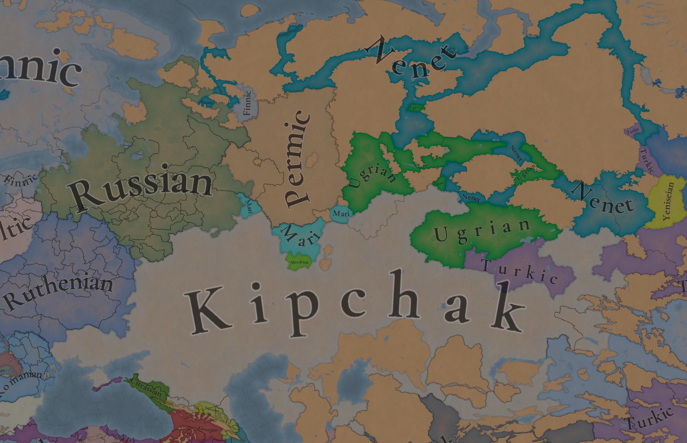
Languages.png

Court Language.png

Common language and court language.

Religions:
Religions.png

This now looks much nicer, with a Tengrist majority in most of the Horde, some more Folk religions added, minorities here and there, etc.

Raw Materials:
Raw Materials.png


Markets:
Markets.png


And that's all for today! Remember that this is this week's schedule:
  • Tuesday -> Tinto Flavour about the Golden Horde
  • Wednesday -> Tinto Talks about Islam
  • Thursday -> Fourth ‘Behind the Scenes’ video!
  • Friday -> Tinto Flavour about the Ottomans and the Rise of the Turks situation!
And also remember, you can wishlist Europa Universalis V now! Cheers!
 
  • 87
  • 69Like
  • 8Love
  • 6
  • 1Haha
  • 1
Reactions:
Good job as always! I've done some research on the region so here's some stuff I found:

-1-The locations of Kominternivske, Dashev, Oleshia, Qalançaq, Or Qapi, Aqmecit, Kezlev, Lusta, Soldaia, Kaffa, Enice, Berdiansk, Mariupol, Taganrog, Azok, Staroshcherbinovskaya, Balzimachi, Akhtar, Temir Baba, Kushkar Am, Beki, Ketik Kala, Astrakhan, Tarki, Dərband and Shirvān should all have some minimum natural harbour suitability
-2-in 1337 there were two polities with the name of Perm, the one in game right now was known as Great Perm and it should be renamed as such, while the other one was known as Little Perm or Vychegda Perm(because it was based along the namesake river) which should be added as a vassal of Veliky Novgorod at start of the game
-3-In 1337 Circassia was not a unified state but a confederation of at least 12 major indipendent semi-nomadic tribes each one with their own rulers, governments and beliefs like Verzacht of Zichia who converted to catholicism a few years before, as such I think that Circassia should be split in 12 parts and made into a formable tag
-4-Vyatka should be a republic with a slavic elite(Novgorodian should be the primary culture since that's where the first settlers came from) as its rulers were elected, both Great and Little Perm were still tribal in 1337 while Avaria should be a Steppe Horde ABC since their state is referred to this day as a Khanate
 
Last edited:
  • 27Like
  • 10
  • 6
  • 3
Reactions:
Only suggestion I would have would be splitting the Circassia tag into separate tribes

Looks tremendous though! Can’t wait to play as the Golden Horde
 
  • 24Like
  • 4
  • 1
Reactions:
Could I also ask you to post here screenshots of locations, provinces, areas and raw goods maps of Pontic-Azov Steppe and Southern part of Ruthenia?
UA.png

I am trying to promote the game in Ukrainian segments of different platforms and I always have to patch the map from 4 different TMs, or use low-res cuts from World maps of videos. It would be nice to have these four as they are the most granular and particularly catchy and interesting to people.
Thanks!
 
  • 14Like
  • 1
Reactions:
Looks like a very weak and rushed feedback, not going to lie. Still Sloboda, still Mishary, still no Moksha culture, the principalities in Ural are still SoP's, still Yerle Qalıq. Most of the commonly raised points are not corrected and community's awesome work on Tatar names and redraws do not seem to have been implemented.
 
  • 40Like
  • 9
  • 5
Reactions:
I'm no expert on the matter but other than give every Uralic culture a different folk religion why not just have Muinaisusko cover all of them? It's not like they have any unique machanic as of now and they were relatively pretty similar considering they "evolved" from the same beliefs, sorta like Tengri is used for both Turkik amd Mongolian cultures
 
Last edited:
  • 8
  • 4Like
  • 2
Reactions:
Why do so many locations have long appendages instead of splitting them into a location and corridor?
 
  • 30
  • 2Like
Reactions:
Also I do not know if it was too late, but hope you will make the Dnipro uncrossable from Islam-Kermen to Khortytsia to represent the great meadow.
Also I see a few locations having very recent names.

Please, take a look at these suggestions, I provided the names for a lot of locations from old maps and from the Crimean-Tatar language.

Caucasus:
Certain locations in the region after the feedback still have obvious Slavic names.
That really breaks immersion and flavour to quite a few few people, so I tried to improve it a bit.
And also improved my own approach to this kind of suggestions.

THIS TIME I
  • avoided pure hydronyms as much as possible,
  • used better maps (Google) to look for alternative settlements nearby with either Turkic/Circassian origin or at least not-so-obvious Slavic names,
  • used Circassian names and sources of those settlements or some information about previous settlements from Wiki,
  • and the most important – used historic maps of the region.

LEGEND
Settlements from the
XV – XVII century maps
Previous Circassian settlements or Circassian settlement names
Nearby settlements with Turkic, Circassian or neutral name
The second row with a question mark means my suggestion for better spelling adaptation.
Like Cabartei Kabartey.
Also used one modern map from multiple Circassian sources.​
Wikipedia sources​
Google Maps used​


MAP

I used standard transliteration from the Cyrillic alphabet, but maybe better to use Turkic-ish spelling: Şanjir, Bjedygu-Kal, Hadiji, Şitkale, Koşehabl etc.?
I hope the devs will handle it better.


The most important thing – of course we cannot locate the exact places from those old maps, so this is some approximation in any case, I am aware of it.
My main reference points were (apart from the mountains and the seas):
  • rivers (especially the Cuban and the Don),
  • relative positions on different maps,
  • scientific articles on old maps of Circassia,
  • information on pages about Circassian history.
  • Bzhedygu-Kal (Bjedygu-Kal ?) - previous Circassian name of Yekaterinodar.
  • Khadyzhy (Hadiji ?) – previous Circassian village on that place.
  • Yessentug – Yessentuki were reportedly named by Yessentug khan.
  • Julat instead of Dzhulat – maybe Horde spelling should be adapted to Turkic spelling.
  • Kara-Bazarprevious Nogay slave-trading settlement before Kochubey.
  • Burgusan – chosen thanks to Zhulat-Dzhulat present on the Circassian and game maps.
  • Cabartei (Kabardey ?), Parapet, Vassanar – chosen based on rivers and general setting.
  • Earlier maps were prioritised.
  • I did not use XVIII century maps a lot because the current settlements were mostly established around that time, so it is not a big difference from Google maps suggestions.
  • One 'modern' map of Circassia in 1450 is from multiple Circassian sources.
  • All those places I used were in multiple maps.

I highlighted the respective settlements on those maps.

Fra Mauro 1459
Cantelli 1684
Circassian source 1450


Gastaldi 1548
De Jode 1579
Keller 1590
View attachment 1292754View attachment 1292755View attachment 1292756


Similar reworks of Volga-Don and Ukrainian Steppe parts are underway!

Volga-Don Steppe:
Following up on the Northern Caucasus location naming suggestions, here are some improved ideas for the Don-Volga part of the Steppes.

Certain locations in the region after the feedback still have obvious Slavic names.
That really breaks immersion and flavour to quite a few people, so I tried to improve it a bit.
And also improved my own approach to this kind of suggestions.

THIS TIME I:
  • avoided pure hydronyms as much as possible,
  • used better maps (Google) to look for alternative settlements nearby with either Turkic/Circassian origin or at least not-so-obvious Slavic names,
  • used Circassian names and sources of those settlements or some information about previous settlements from Wiki,
  • and the most important – used historic maps of the region.

Special thanks to the forum for cooperation.

LEGEND
Known pre-1337 Horde cities
Settlements from the
XV – XVII century maps
Previous or local settlement names
Nearby settlements with Turkic origin or neutral name
Local (Turkic)
river names
For most of them locations are probable, mentions in the chronicles are matched with big archaeological sites.​
The second row with a question mark means my suggestion for better spelling adaptation.
Like Boletecoi Boletekoy.
Also used one modern map from multiple Circassian sources.​
Wikipedia and local historic sources​
Google Maps used​
Used when no better options were found​

MAP


I used standard transliteration from the Cyrillic alphabet, but maybe better to use Turkic-ish spelling: Şanjir, Bjedygu-Kal, Yaşalta etc.?
I hope the devs will handle it better.

The most important thing – of course we cannot locate the exact places from those old maps, so this is some approximation in any case, I am aware of it.
Further details in notes.
  • Bzhedygu-Kal – previous Circassian name of Yekaterinodar.
  • Vassanar, Codicoi, Cogia, Cremuch, Acua, Tzerkas, Zingis, Boletecoi, Azaraba, Besinda, Nabars, Achas, Azabar, Scosna, Tuia – chosen approximately based on main rivers, seas, mountains and general setting on multiple maps.
  • Pexo/Peso/Pesso – different variations on different maps through time. Or can be Azara.
  • Lysychansk -> Bayrak (previous early Cossack name was Lysychiy Bayrak, and 'bayrak' is a Turkic word, so get rid of the adjective and we have a good name).
  • Luhansk -> Verhunka (the earliest Cossack settlement there, Turkic root Verhun, so could be also Verhun).
  • Posad -> Kayaly/Kayala. It is a river known from the Rus chronicles in Azov Steppe and could be associated with the Kalmius river. Also Posad is just a generic term for a settlement. Obviously it represents modern-day Donetsk, but all of my Donetsk friend were surprised to see it because they did not know (neither Google) about any kind of 'posad' in the history of Donetsk.
  • Special funny note about Yebok Wiki page Ебок. For those, who do not understand, it was literally called a Fucking Settlement (in Russian) by the Don Cossacks.
  • Earlier maps were prioritised.
  • I did not use XVIII century maps a lot because the current settlements were mostly established around that time, so it is not a big difference from Google maps suggestions.
  • One 'modern' map of Circassia in 1450 is from multiple Circassian sources.
  • Those names I used were mentioned in multiple maps.

I highlighted the respective settlements on those maps.

Fra Mauro 1459
Vesconte 1318
Canepa 1489


Gastaldi 1548
De Jode 1579
Keller 1590
View attachment 1296084


Mercator Atlas 1590s
Mercator 1595
Mercator 1636
View attachment 1296098View attachment 1296087


Hagen 1638
Cantelli 1684
Circassian source 1450


Similar rework of the Ukrainian Steppe is underway!

Ukrainian Steppe:
Following up on the Volga-Don location naming suggestions, here are some improved ideas for the Wild Fields (Ukrainian Steppe) region.

Certain locations in the region have obvious Slavic names.
That really breaks immersion and flavour to quite a few people, so I tried to improve it a bit.
And also improved my own approach to this kind of suggestions.

THIS TIME I:
  • avoided hydronyms as much as possible,
  • used better maps (Google) to look for alternative settlements nearby with either Turkic/Circassian origin or at least not-so-obvious Slavic names,
  • used historical Crimean Tatar names and sources of those settlements or some information about previous settlements, rivers, their etymology,
  • and the most important – used historic maps of the region.

LEGEND
Golden Horde cities
Settlements from the XV – XVIII century maps
Location names in the Crimean Tatar language
Previous or local settlement names
Nearby settlements with Turkic or neutral name
Turkic
river names
Correct Ukrainian spelling
Locations are probable,
mentions in chronicles are matched with archaeological sites.​
Old maps used.
Spelling standartised (but Crimean spelling needs to be revised).​
Old maps and Crimean sources used.​
Local historic sources​
Google Maps used​
Used when no better options were found​
Both starting locations and for the dynamic naming​


MAPS


This time I also used the Crimean Tatar alphabet to spell those locations for 1337 (my suggestions need to be revised especially k/q since I have no background with this):
View attachment 1300095


IMPORTANT: since most of those maps were made by western Europeans via Polish perception of Tatar / Ukrainian spelling (or even also via Ruthenian between Tatar and Polish), you can find a lot of spelling inconsistency, so I use standard Ukrainian names for dynamic naming and historical/actual Crimean Tatar names where possible for 1337.

Tatar Naming suggestion in green / Ukrainian naming suggestion in yellow:
  • Buzhskyi, Drahushiv, Zavallia, Torhovytsia, Krasnyi Kut (please, correct Ukrainian spelling).
  • Also for 1337 Torhovytsia -> Yabu and Vasylivka (near Zaporizhzhia) -> Yedi Cami and Orhei -> Yangi-Şehr (big archaelogical sites of the Golden Horde cities of the XIV century, supposed to have had these names; note you have another Vasylivka in Donbas; note that that Vasylivka location includes two archaelogical sites of large Horde cities - Yedi Cami and Mamay-Saray – probable capital of the Mamay Horde).
  • Odessa -> Kocabey / Kochubiy (multiple mentions on old maps, the settlement appeared long before it was named Odesa; Kocabey is the correct Crimean Tatar spelling, Ukrainian can be Kochubiy/Kochubey/Kotsubiv; lastly, Odessa is Russian spelling with -ss-).
    View attachment 1300433
  • Kominternivske -> Teligol / Kordon (Kominternivske is a communist name, so I have chosen a nearby town called Kordon for Ukrainian naming; and Teligol was on multiple old maps).
  • Voznesensk -> Keşeni / Syni Vody (multiple mentions of Chryzkeszeni and Szinouoda settlements on old maps in the area of Voznesensk-Pervomaisk; keşeni means 'field mosque' in Tatar and it is unknown what exactly that Chryz- meant, to it can be just Keşeni; Szinouoda is obviously Syni Vody, the place of the 1362 battle, currently called Syniukha).
  • Nova Odesa -> Çapçaqlı / Andriiv (multiple mentions on old maps in the very same place; also since Odesa is not very relevant for the game, Nova Odesa is even less relevant).
  • Nikolaev -> Vithold Hammami / Vynohradna Krynytsia (both mentions on old maps, former Vitautas castle and trading post, mentioned as Balneum Vitoldi in Latin; lastly, Nikolaev is Russian spelling).
  • Ochakov -> Cankerman / Dashkiv/Ochakiv (multiple mentions on old maps; Dashkiv was the earliest name, mentioned in early Polish documents (source, p.124); sometimes maps showed both Dashiv and Ochakiv, that was an early maps error; Cankerman (Dzhan-Kerman) is correct initial Crimean Tatar name, reflected by Dziankermenda name in multiple old maps; lastly, Ochakov is Russian spelling).
  • Kherson -> Tehin / Tiahynka/Kherson (multiple mentions on old maps, Tehin is Turkicised, Tiahynka is Ukrainian name).
  • Kropyvnytskyi -> Ingul / Inhuletska Sloboda (Kropyvnytskyi is a recent name; the first Cossack settlements (one of them was Inhuletska Sloboda) were named after the major river Inhul even before it was named Yelysavet, mentioned on old maps (e.g. Inhul-horod); Ingul has also Turkic origin).
  • Numerous unreadable locations along the Dnipro -> İslam Kermen, Ğazı Kermen, Rohat Kermen, Tencay, / Oleshky, Beryslav, Kakhovka, Dudchany (Tatar towns documented on numerous old maps; Ukrainian names are much more relevant and short; e.g. Kakhovka was previously Islam-Kermen and Beryslav was Gazi-Kermen).
  • Velyka Bilozerka -> Aççı Su / Dniprovka (Aççı Su is the Crimean Tatar name for the Bilozerka river; and Dniprovka for Ukrainian is just shorter).
  • Lykhivka -> Saqsagan / Zhovti Vody (For Ukrainian name Zhovti Vody is far more relevant historically due to the famous 1648 battle, the place is also mentioned on old maps; also Saksahan is a local river with an obvious Tatar origin).
  • Ltava -> Oril / Oril (multiple mentions on old maps, also Ltava was ancient Poltava).
  • Kodaky -> Kudak / Kodak (Kodaky is a modern name, I suggest using the name mostly mentioned in old maps and the old Ukrainian name instead).
  • Zaporizhzhia -> Küçük As / Kichkas (Zaporizhzhia as a location name is quite anachronistic, that place was known for centuries as Kichkas, an important Dnipro crossing, multiple mentions on old maps of the Kichkas (Kaczkasow) river; Crimean Tatar name origin çük As).
  • Krasnohrad -> Parhom-Bayraq / Berestyn (Krasnohrad is a communist name, previous historic (and also current) name is Berestyn; but before that there were mentions about Cossack steppe winter settlements called Parkhomivski Bairaky, that is of the Tatar origin; alternatively, Berestyn can be used for both).
  • Barvinkove -> Balıqley / Balaklia (bigger, shorter name of the Tatar origin, probable balıq ley – 'fishy river').
  • Kharkiv -> Donets / Kharkiv (it was already confirmed to be renamed to Donetsk, but better use Donets, please; for Ukrainian maybe better leave Kharkiv).
  • Pokrovske -> Yalı / Hryshyne (Yaly is a local river with clear Tatar name; Hryshyne is the previous historic name of Pokrovsk, also Pokrovsk is a very popular generic town name, probably there may be a couple of others in Russia).
  • Oleksandrivka -> Boyuq / Dobropillia (Byk is a local river which name comes from the Crimean Tatar boyuq (big); Dobropillia is just better because Oleksandrivka is very popular and generic for the eastern Slavs, to avoid similarities).
  • Mariupol -> Adomah / Domakha (previous early Cossack settlement Domakha, that came from the Tatar Adomah).
  • Kupiansk -> Şarukan(?)/Oskil / Kupiansk (maybe we can use the legendary Kipchak town name here?)
  • Lysychansk -> Bayraq / Lysychiy Bairak (previous early Cossack name was Lysychiy Bairak, and 'bayrak' is a Turkic word for a specific Steppe terrain).
  • Luhansk -> Vergun / Verhunka (the earliest Cossack settlement Verhunka there, of Turkic root Vergun).
  • Posad -> Kayaly/Kayala / Makiivka (Kayala explained in the previous post on Volga-Don; Makiivka appeared as a Cossack settlement much earlier than Donetsk-Yuzivka, so it is better for Ukrainian name).
  • Vasylivka (near Taganrog) -> Sarabaş / Snizhne (there is already one Vasylivka on the Dnipro, so I suggest Sarabaş as a local Turkic location and Snizhne as Ukrainian; actually, Snizhne was previously also called Vasylivka, this is a very generic town name).
  • Rovenky (near Taganrog) -> Mius / Dovzhansk (there is already one Rovenki in Russia nearby, close to Belgorod and Valuyki, so for Ukrainian name it is better to choose Dovzhansk; and Mius has already been mentioned in the previous post).
  • Other names probably do not need special notes, you can find them on Google Maps or on the old maps attached.

OLD MAPS FROM TIME PERIOD
I highlighted the respective settlements I used on those maps and made some comments.

Bianco 1436
Munster 1550
Forlani 1568


Keller 1590
Mercator 1595
Radziwill 1613
View attachment 1300882


Blaeu 1645
De Beauplan 1648
De Beauplan 1648
View attachment 1301013View attachment 1300892


Visscher 1657
Sanson 1665
Ratelban 1747


Bellinn 1772
Zannoni 1774
Zannoni 1774


And a couple of other useful sources I used:
I hope this will be of help for this really challenging region!

The Great Meadow:
THE GREAT MEADOWI have realised that for better geographical and historical representation of the Dnipro Steppe the Great Meadow must be represented.
It shaped the whole warfare and borders in the region because it made a huge ~150 – 200 km section of the Dnieper uncrossable (between modern-day Zaporizhia and Kakhovka).
 
Last edited:
  • 38Like
  • 9
  • 3Love
  • 1
  • 1
Reactions:
Goths still speak Greek?? Why? In 1337 they definitely were Germanic-speaking.

A Flemish diplomat by name of Ogier Ghiselin de Busbecq travelled to Crimea in the 1560s. There he recognized that the language of the Crimean Goths was distinctly Germanic and shared many similarities to his own native, Germanic tongue.

Although many Goths did adopt Tatar or Greek language as a secondary language to communicate with foreign merchants and such, it is thought that Gothic itself did survive (and thrive) until the late 1600s. After this however, it suffered a decline it did not recover from, sadly. :(

Still though, it was the language of the common people during the game start, and should be represented as such. If they were still Germanic-speaking in the 1560s, they should be in 1337!


EDIT: yay
gutþiudainaustrs.PNG
 
Last edited:
  • 28
  • 10Like
  • 7
  • 2
  • 1Haha
Reactions:
Since you have changed the name of the country to Veliky Novgorod I feel like that the location and the area's names should be changed to Veliky Norvgorod as well
 
Last edited:
  • 1
Reactions: