Greetings everyone!
Today I’m here to talk about one of my favorite parts of our games (a very important one too) and something I’ve been working on. I’m going to talk about the map.
Looking at the work @Trin Tragula does for the map on EU4, I started thinking. Why don’t we do something similar to CK2? So I went looking at the map for various possible improvements. I have not added anything new in terms of provinces or areas. Instead, I wanted to focus on improving the existing map and give it some needed polish.
The CK2 map is not perfect, so there are a quite a few places to look at. But I wanted to start with the terrain and topology. As there several places on the map that, frankly, look out of place. As such, I swooped the map of the most hideous offenders. Several lakes and most major rivers are now much smoother, avoiding ugly and sharp edges. The Ural Mountains are now mostly impassable.
Below you can see a few examples.
Ural mountains:

Lake Baikal, old and new:


The Ganges, old and new:


I also took this opportunity to make some smaller de jure adjustments (I know that not everyone will agree with me on these). These are done for gameplay reasons and considerations. The largest change will be for the kingdom of Cumania. Which I broke off slightly by giving the duchies of Itil and Sarkel to Khazaria, along with Crimea and Cherson (so Taurica no longer holds any de jure land).
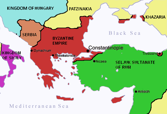
A small shift in the kingdoms of the ERE. Greece is a very large kingdom, so I made it slightly smaller by moving Samos and Cibyrrhaeot to Anatolia, and in turn, made Anatolia stay close to the same size by making the duchies of Trebizond and Armeniacon de jure to the kingdom of Trebizond.

Last, and definitely not least. Let’s take a look at Hungary and the Danube. The first thing I did was to redraw parts of the Danube to make it more accurate (as we all know, the old Danube was not quite where it was supposed to be). It now flows much closer to its actual location. The counties along the river have been adjusted accordingly. Pecs, for example, is now located on the correct side of it. The rest of Hungary has also been adjusted so that the kingdom is placed within the Carpathians.
Instead of taking my word for it, you can see for yourself in the screenshot below, in which you can see the updated coast of Croatia as well.


Does this make the map perfect? No. But I do think it’s a step in the right direction and an improvement over the previous one.
Let me know what you think!
Today I’m here to talk about one of my favorite parts of our games (a very important one too) and something I’ve been working on. I’m going to talk about the map.
Looking at the work @Trin Tragula does for the map on EU4, I started thinking. Why don’t we do something similar to CK2? So I went looking at the map for various possible improvements. I have not added anything new in terms of provinces or areas. Instead, I wanted to focus on improving the existing map and give it some needed polish.
The CK2 map is not perfect, so there are a quite a few places to look at. But I wanted to start with the terrain and topology. As there several places on the map that, frankly, look out of place. As such, I swooped the map of the most hideous offenders. Several lakes and most major rivers are now much smoother, avoiding ugly and sharp edges. The Ural Mountains are now mostly impassable.
Below you can see a few examples.
Ural mountains:
Lake Baikal, old and new:
The Ganges, old and new:
I also took this opportunity to make some smaller de jure adjustments (I know that not everyone will agree with me on these). These are done for gameplay reasons and considerations. The largest change will be for the kingdom of Cumania. Which I broke off slightly by giving the duchies of Itil and Sarkel to Khazaria, along with Crimea and Cherson (so Taurica no longer holds any de jure land).
A small shift in the kingdoms of the ERE. Greece is a very large kingdom, so I made it slightly smaller by moving Samos and Cibyrrhaeot to Anatolia, and in turn, made Anatolia stay close to the same size by making the duchies of Trebizond and Armeniacon de jure to the kingdom of Trebizond.
Last, and definitely not least. Let’s take a look at Hungary and the Danube. The first thing I did was to redraw parts of the Danube to make it more accurate (as we all know, the old Danube was not quite where it was supposed to be). It now flows much closer to its actual location. The counties along the river have been adjusted accordingly. Pecs, for example, is now located on the correct side of it. The rest of Hungary has also been adjusted so that the kingdom is placed within the Carpathians.
Instead of taking my word for it, you can see for yourself in the screenshot below, in which you can see the updated coast of Croatia as well.
Does this make the map perfect? No. But I do think it’s a step in the right direction and an improvement over the previous one.
Let me know what you think!
- The Ural mountains are now impassable
- Removed the duplicate island of Kolguyev, in the Barents Sea
- The most northern part of the Onega is now properly filled with water
- The mountains in southern Abyssinia no longer stretches onto the frame of the map
- Fixed an issue in the lower part of the river Don, where the river bed would go above water level
- Removed a bunch of trees that were placed in major rivers
- The terrain around lake Balkhash has been smoothed, to avoid sharp/rough edges
- The terrain around lake Baikal has also been smoothed, no longer will the steep cliffs surround the lake
- The Indus and the Ganges have both been cleaned up:
- The terrain now matches the actual river
- Smaller rivers no longer flow so far into the major rivers
- The borders of the rivers has been made smoother to avoid sharp/rough edges
- The Danube has been redrawn, to better represent its actual location (!)
- The county of Constantinople is now only located on the western side of the Bosphorus, merging the eastern side into the county of Nikaea, connected with a strait
- The duchies of Samos and Cibyrrhaeot are now de jure part of the kingdom of Anatolia, rather than Greece
- The duchies of Trebizond and Armeniacon is now de jure part of the kingdom of Trebizond, rather than Anatolia
- Removed the kingdom of Taurica
- The duchy of Crimea is now de jure kingdom of Khazaria
- The duchy of Cherson is now de jure kingdom of Khazaria
- The coastal counties of Croatia and Serbia have been adjusted and moved slightly to better represent their actual locations
- The eastern counties of Hungary and the surrounding area has been moved and adjusted in order to properly place the kingdom within the Carpathian mountains
- Changed the name of b_mirabel to "Majdal Yaba"
- b_mirabel will be named "Mirabel" if ruled by most European cultures
- b_mirabel will be named "Antipatris" if ruled by Byzantine cultures
- The county of Tobruk is now only located along the coast
- Moved the northern part of c_dalarna to c_herjedalen
- Moved k_venice to de jure e_italy