• We have updated our Community Code of Conduct. Please read through the new rules for the forum that are an integral part of Paradox Interactive’s User Agreement.

CK2 Dev Diary #79 - Beautifying the Baltics

Greetings!

Work is progressing splendidly on the upcoming expansion, alas it is still much too early to start talking about any of its many features. Instead, we’ll continue our tour of the cartographer's office.

As I mentioned in the last Dev Diary we’re working our way through some of the more neglected areas of the map - primarily (but not exclusively) focusing our efforts on areas that weren’t that interesting to play in. This time around we’re teasing the upcoming changes to the Baltics, primarily based on tribes that populated the region before the Northern Crusades, again courtesy of [Arthur-PDX]. This time I thought of providing you with a side-by-side comparison, so you can see the changes for yourselves, without having to boot up the game:
Baltics Update.png


Code:
- Map Update to the Baltics
       - Major overhaul to the Baltic region (mostly encompassing the Kingdom of Lithuania's DeJure territory)
      - (Major) river Daugava moved and reshaped a bit for more accuracy
       - Minor river crossings in Lithuania reshaped for more accuracy
      - 7 provinces added to enhance pre-Livonian Order flavour
       - New duchy of Latgale added
      - All old provinces in the DeJure Lithuanian Kingdom's territory have been reshaped for more historical & cultural accuracy
      - New kingdom of Estonia, formable by holding the duchies of Estonia and the new duchy of Kalava

Please note that the time between Dev Diaries will be irregular, as we’re very early in the development cycle.
 
btw, what's wrong with my post? With what do you disagree? I thought I only asked how you Poles think the problem with wrongly named province should be solved.
The disagree must have been a misclick. Don't mind it.
Been checking with some other people internally, and from what we discussed, the issue is that Neumark, when Polish, was part of Lubusz (or another province that is already in game and separate), so it was kind of an awkward situation.

The maps I checked were calling the region "Now Marchia" as well, thus the original naming, but I was curious and we talked about it a bit with others. I've decided to name the province "Santok" (based on its main holding) when it's in Polish & Pomeranian hands (maybe Czech as well, but I don't remember).


Arthur
I guess it fits. A similiar solution was done in EU4 as well.

On a side note, have all missing "ó" letters in Polish province and holding names been added? Right now "ó" is the only Polish letter that can be used in CK2 due to the game's encoding system but it's still better than nothing.
 
Last edited:
Although it pains me to say this, but Žemaitija (samogotia) never technically had connection to the sea. It was very important region and I would even say that it should have more holdings than neighboring provinces, since it alone could push back enemies. But again, it never had port or anything and at best relied on Ventė/Skalva (in game Scalovia province though Memel shouldn't divide Žematija and Scalovia at this point in history or province Lamata should be added in northwest Scalovia and south Memel) or Palanga for its connection to Baltic sea. Palanga was vassal of Žemaitija at one point, but for most of its history it was under Memel or, before Teutons, Kuršas (Kuršžemė in game) or more precise - Mėguva/Pilsotas (region from Klaipėda/Memel to river Bartuva or Liepajos lake).
I would suggest cropping Žemaitija a bit but in return giving it more holdings than average on this area and giving some defensive buildings with better garrison from the start. Also adding very small province Palanga (or Mėguva if you want to be historically accurate) so you could give it to Lithuanian Kingdom at the start dates where it is already united. And by making it something like 1-2 holding province you'll represent the fact that it was never major harbor city in the region perfectly.
Here are some reference maps, but they aren't very precise since their point is to show cultural borders at around 10th century: http://istorijatau.lt/rubrikos/zemelapiai/436-baltai
I do have some more precise maps but couldn't find those on internet. Here in Lithuania there are some nationalistic sentiments that we were once huge nation from Baltic to Black seas and thus facts and historical analysis that lessens this aren't looked favorable upon

I looked at Kuržemė (Courland) maps today and found one which is also posted on the internet and which shows my point perfectly. As you can see Mėguva is not part of Žemaitija in 1253 (Lithuania becomes Kingdom under Mindaugas, yet Western Lithuanian lands are still not integrated), but part of Kuržemė instead. And this is the corridor that Lithuania managed to hold from Teutons and Livonians for some time and keep it as country's only port (Palanga, capital of Mėguva). It was besieged several times by Teutons while rest of Kuržemė was beginning to surrender to Livonians. At that point region came under Žemaitija and when Kęstutis was trying to strengthen Samogotia and Lithuania ties, he picked priestess from Palanga as his wife and she bore Vytautas The Great, later de facto ruler of Lithuania in not so united Polish-Lithuanian commonwealth beginning at that time.
Also you can see my mentioned Pilsotas region in this map. Before Teutons Southern part of Pilsotas had better relations with Samogotians than any other part of Courland. It is where Ventės Ragas, also know as just Ventė, is located. But, since it only had strong ties and never was part of Žemaitija (even not today - it is part of Little Lithuania or Klaipėdos kraštas region), I would suggest that It would be more historically accurate to fix Smaogotian borders by adding Mėguva. Also there is Duvzarė region, which lost part of its southern lands when Mėguva came under Samogotia and thus we have borders that are a bit different at later date for this province and also which are today part of Samogotia. Lastly, Palanga castle was gateway for Danes and Swedes when they raided Western Lithuania. You can see city of Apuolė marked on this map. To get to it, raiding parties had to first stop at Mėguva's Palanga castle instead of another bigger town in that region - Impiltis (also shown on map). Which shows that region had its distinct territorial significance even before Lithuania's unification.
So my suggestion stands as before - add 1-2 holding Mėguva province and give it territories showed on this map including western Samogotia (also known as Samogotian plains. It goes at around that river showed in this map, or to be more precise Kretinga city) and southern parts of Duvzarė which later became part of Samogotia.

OldCourland.jpg
 
I looked at Kuržemė (Courland) maps today

Hey, beautiful map right there !

I've checked what you mentioned, and indeed the "corridor" was an interesting choice to make. Basically it was added for gameplay reasons mostly. I one version I removed it so you had to control either Kurs or Skalvia to have sea access, but it didn't feel good enough in my opinion, that with the added Lithuanian corridor which is handy for later bookmarks.
TL;DR : Gameplay reasons mostly

As for adding more provinces in the Baltics, we prefer to keep it at what we have right now, 'cause we already have quite a pack we're satisfied with, and adding more provinces obviously has some impact on balancing, so it's very very unlikely that we add more stuff in this area. I might take a look at holdings and make some tweaks with the help of that map tho, we'll see.

On a sidenote, where did you get this map from ? I'd be curious to see if whatever it comes from has some more interesting data

Cheers,


Arthur
 
Sure, I do understand that. Those two provinces you've mentioned definitely wouldn't feel right since they are both very distinct from Samogotia. Until 10 century their languages were very similar, but at that point half of modern Belarus and western parts of Russia still had lots of Baltic traditions (rivers, plains, hills and valleys up to Moscow are named by Proto Balto-Slavic names) but making them not that distinct would brake game if you would take any date later than Charlemagne start. So I get it. But with Mėguva and Pilsotas is completely different story, it was more related to Lithuanian culture specifically "Lematian" culture branch than to Couronian culture. Thus I like that you've at least added Mėguva as a corridor to Samogotia, which represents later dates also.

I suggested this only to represent my mentioned Palanga political shift in game. And also, because past few years, question of Samogotia's connection to the sea was hot topic in Lithuanian history community with one particular popular historian A. Bumblauskas bringing some very controversial topics in his non-academical books. Despite that I'm fine with Mėguva being already integrated part of Samogotia. It is too small of a detail yet an interesting one.
Shame that you are done with the map since there are some very weird looking borders between Deltuva, Nalšia and province which you've named Kaunas for some reason (there was never, even not today, region called Kaunas. You MUST at least change province name to "Aukštaitija"). Also, what in the hell happend to Nemunas river? o_O Why it became horizontal? It goes up to Kaunas city and then bends to Belarus. Here: http://lietuvai.lt/w/images/2/29/NemunasInLithuania.png
Despite that, I'm happy to see Nalšia and Deltuva added to the map. Those were two important provinces in Mindaugas time when his vassals revolted against him. A bit strange to see my hometown (Panevėžys) in Deltuva and not Aukštaitija region but I'll trade that for not being in Žemaitija :) . Shame that Trakai is gone, since it was de facto capital of Lithuania for some time in game's timeline, but it hasn't kept its status as separate region from Vilnius anyway.

As for the map, it is from Arvedas Swabas "Straumes un avoti", but it is in Latvian language. Can't remember if I have anything similar in English. There are quite a few chapters on Courland.
Also there is nice book of Algirdas Seibutis "1009 metų Lietuvos pasienio geografinė apybraiža" (Lithuanian border geographical summary of 1009. <-- My own translation) Not much in terms of quantity of maps but its a book dedicated to 11 century borders so some quality there .
 
2 maps of Latvia in the 12. century.

lvhistory2.png

kar114.jpg


A map of the Baltic region in the 9.-11. century. The red arrows are curonian and estonian raids into Scandinavian lands. The blue arrows are scandinavian raids and main trade routes.

kar113.jpg


A map of the Baltic in the 5.-10. century.

kar111.jpg


As you can see in the maps Curonian (Kurši) territory wasn't cut off by Žemaitija but instead their teritory went more into modern day Lithuania.

BTW most of these maps are from a latvian government organisations Valsts izglītības satura centrs (National education content center) website visc.gov.lv
 
First 2 maps are helpful, but rest are too general when it comes to territory. Latvia part of the map is quite well done already. And it is understandable since there are way more historical documents referring to Latvia territory. It was attacked by Scandinavians more so there are their sources of it, Germans colonized those lands so there are those sources and finally people there haven't resisted Christianity as much as Lithuanian tribes did - thus there are sources from missionary work.
When it comes to Lithuania we managed to push back initial colonization attempts and raid neighboring provinces to have resources for defense. Thus there are only mentions of raids from Lithuanian tribes without giving detail of where those land were. It is no doubt that Lithuania was dominant power in the region by a long shot but this fact is represented very poorly in game. Now that Latvia lands got tons of new provinces and Lithuania just couple additions I have similar fear that Baron of Red mentioned - how those new provinces affect game balance. Fact that coastal lands have more sources for territorial borders shouldn't affect historical balance of power in region.

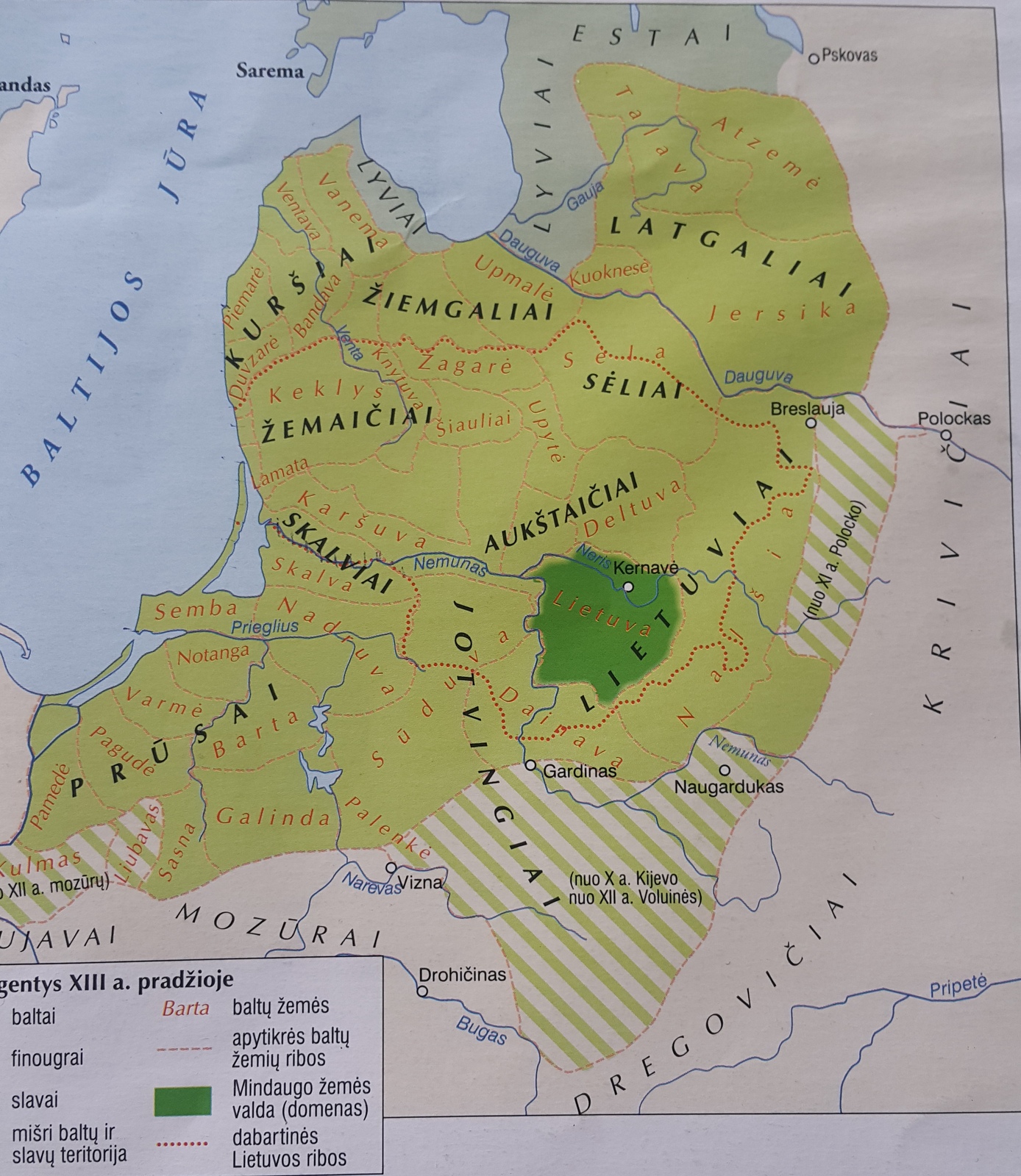
As for maps, I found one which has more detailed borders of different tribes marked by dashed lines:
20180309_150628.jpg
Since it was in history atlas I can't find author of this map, but I found very similar looking one in Edvardas Gudavičius study.
 
North Africa isn't really a problem. The steppes are.
We're on the Baltics rights now; one steppe at a time, alright?

*Throws tomatoes at self for such a convoluted pun*
 
Where was North Africa mentioned in this thread?
actually several times...
I'd be very surprised if Africa didn't get at least some attention in the great map update. And also very disappointed.

No. Please, not that.
Africa needs lot of love, but please, there's no need to go south from Mali

(says one of the biggest defender of Africa)

I god damn called it!!! I knew we were gonna have the Kingdom of Estonia!!!
Next, we will either get a re-working in Thrace, or see new provinces in North Africa!!!

Too bad you miscalled the next one :D

True enough...but if you guys are doing any updates to North Africa...you should probs take into consideration implementing a
Maghreb Culture Group hint hint, wink wink, nudge nudge. ;)

Just saying though...we ain't talking about anything official at all.....

Sorry to say that, but that suggestion makes no sense in the CK2 time period. Back then there was no Moroccan, Algerian nor Tunisian cultures nor identities in the region..
During the CK2 era the major groups in the region were the Sanhaja, Zanata and Masmuda Berber tribal confederations, who shaped the fate of the region... and since mid 11th century Hillalian Arabs, who were in fact Bedouin arabs by CK2 cultural divisions...

Only after Hillalian expansion substantial Arabization have started, but still the Arab-Berber antagonism as well as hostilities among Berber confederations were essential, not some early modern identities which started to be shaped after 14th centuries and became real only after Ottoman occupation of Tunisia and spread of their influence into modern day Algeria in late 15th and 16th century.

As for more accurate division of kingdoms... there could be kingdons of Maghreb, Africa/Ifriqiya and perhaps Mauretania in the far west... but it all depends on the level of detail... if there would be any map overhaul of the region. You can just check my map mod in my signature. Unfortunately I don't have time to maintain it anymore, but it can serve as good inspiration...
and there was also a discussion about Africa stretched on several pages of this thread.

But I guess he meant the problem of AI that catholic europeans conquer North Africa way too soon and way too often, especially in the early bookmarks?
 
Last edited:
actually several times...


and there was also a discussion about Africa stretched on several pages of this thread.

But I guess he meant the problem that AI of catholic europeans conquers North Africa way too soon and way too often, especially in the early bookmarks?
Exactly
 
Last edited:
Will Bohemia get a bit of help? I think the big problem is that it is starting to feel far too weak compared to its neighbours. While I realise not all counties are created equal and that Bohemia has some nice counties, It seems though that other states are a bit too powerful. Afterall all counties can be fully upgraded to have 9 holdings. I dont know what would be a good number but maybe increase Bohemia or Moravia or both with 1 county each?

yeah, and give znojmo prov to moravia duchy, not to pesky bavorians.
 
Better rename Znojmo. While Znojmo would be Moravian, the geographical region of this province on the map is clearly Austria.

yeah, i allways thouht that znojmo is to far to south, so redraving/renaming areas here is best solution.
 
Hm, I have to admit Bulgaria isn't a strong point for me, but it doesn't sound completely unlikely?

I'd have to look into the area a bit more to be able to give a proper answer.

Presently playing in Wallachia, and I could imagine getting rid of the Empire of Carpathia and carving out an Empire of Bulgaria from it and Byzantium. Using this as a guide, it would include the kingdoms of Bulgaria and Serbia, adding Wallachia and maybe splitting Pannonia into kingdoms of Avaria/Hungary (Bulgarian Empire) and Carinthia (Wendish, Germania, or HRE, depending on start date)? Maybe Carinthia and Croatia form a miniature Austrian empire?

752px-Bulgaria_Simeon_I_%28893-927%29.svg.png