• We have updated our Community Code of Conduct. Please read through the new rules for the forum that are an integral part of Paradox Interactive’s User Agreement.

Tinto Maps #10 - 12th of July 2024 - Syrian Levant & Egypt

Hello everyone, and welcome to another Tinto Maps! We’re back after celebrating the most important victories over Germany and France since the 30 Years War a hard week of work, and we’re ready to share with you the region of the Syrian Levant & Egypt (actually, we’re revealing a bit more of what those regions would be, to cover the complete extension of the Mamlūk Sultanate). Let’s go!

Countries:
Countries.png

The Mamlūk Sultanate is the main power of the region, a situation achieved after the defeat of the Mongols at the Battles of Ain Jalut and Marj al-Saffar, and the fall of Acre, the last stronghold of the Crusader states in Outremer. The latter's legacy is still handled by the Kingdom of Cyprus, ruled by Hugues IV of Lusignan. Apart from that, we can see the realm of Candia, a subject governed by the Serene Republic of Venice, and some Arabic tribes, such as the Hutaym and the Anizah. Oh, and also, to the south-west, you might have noticed some oases ruled by either the Mamluks, or Fezzan; I opted for not coloring the wastelands, as usual, but also the corridors, a type of terrain present in other GSGs, that we have in Project Caesar. I’ll talk more about them under the ‘Locations’ section of the DD, but I just want to note one more thing: the connection down the Nile is a regular one, with a border existing between the Mamluks and Makuria (the country that controls the small chunk of land at the very south of the image).

Dynasties:
Dynasties.png

The Bahri Mamluks have ruled the Sultanate since they deposed the Ayyubids, almost a century before the start of the game. It could maybe be a bit more accurate to depict Sultan al-Nasir Muhammad as an ibn Qalawun (‘of the lineage of Qalawun’), but the dynastical dynamics of the Mamluk rulers are not so easy to portray, so we opted for the moment to better use Bahriyya. Apart from that, you may also see the neighboring dynasties, such as the already-mentioned House of Lusignan, or the Hethumian of Cilicia.

Locations:
Locations 1.png

Locations 2.png

Locations 3.png

Locations 4.png
Here you can see the locations of the entire region, and also closer chunks behind the ‘Spoiler’ button. The most interesting feature to talk about is that of the corridors, something that some of you might remember from ‘Imperator: Rome’, but also something new to the rest. The corridors are empty locations, with no population or resources, but that allows connection between the locations at their sides, for some mechanics that we’ve already mentioned (market access, control), and some others that we haven’t (army movement). This is the way that we’ve chosen to portray the Saharan corridors, that allow for a connection between the Maghreb and the Mashreq, and Western and Central Africa. There are also some regular locations over those corridors, with population, resources, etc., that can be controlled by countries, which portray the desert oases that made for important outposts in the different Saharan routes. Not all the connections are throughout corridors, though; outside of the image, the Nile River valley allows for regular locations all the way down from Egypt to Nubia, the last location held by the Mamluks being that of Aswan, while the first held by Makuria, not shown in the screenshot, being Qasr Ibrim. We will talk more about Nubia and Ethiopia in a future Tinto Maps.

Provinces:
Provinces.png

Usual provinces mapmode; please let us know of any spelling or naming suggestions that come to your mind.

Areas:
Areas.png

A new mapmode that has been requested in previous Tinto Maps, and that we’re now incorporating.

Terrain:
Climate.png

Topography.png

Vegetation.png

The climate is dominated by a mix of Mediterranean, Arid, and Cold Arid. The topography of the region is quite flat, with some hills and mountains on Mount Lebanon and Anti-Lebanon, Mount Sinai, and the verge of the Arabian plateau; and some marshland over the Nile Delta, of course. Regarding the vegetation, desert and sparse vegetation dominate most of the region, with some woods and forests over Levant, and the Nile fertile farmlands, the bread basket of the Eastern Mediterranean.

Cultures:
Cultures.png

Here starts the fun… Those countries ruling over the Middle East will face the challenge of managing several different cultural minorities. Libyan, Egyptian, Sa'idi, Bedouin, Ḥijāzī, Najidi (the green one to their right), Levantine, and Iraqi (the light blue at the top right of the picture) are all different regional cultures of Arabic-speaking people. Something interesting is that most of Bedouin pops are tribesmen, instead of peasants, portraying their traditional social organization. Coming to important minority groups, Coptic people are quite important in Egypt, accounting for about 10% of the population of the Mamlūk Sultanate. The other important minority are the Syriacs, as they also account for another 10% of the population, and are a cultural majority in a few locations. Apart from those, there are also Armenians, Kurds, and Turkomans on the divide between Anatolia, Syria, and Jazira, Alawites Shiites in Syria, Mizrahi Jews all over the region, Samaritans in Palestine, and Greeks in Crete, Cyprus, and some in Alexandria. Oh, also the Saharan cultures of the Eastern Berbers and the Toubou over some of the Saharan oases.

Religions:
Religion.png

More fun. In this region, we have:
  • Sunni Muslims
  • Miaphysite Christians
  • Orthodox Christians
  • Shia Muslims
  • Catholic Christians
  • Druzes
  • Jews
  • Nestorian Christians (the ‘label’ we’re using to depict the Church of the East)
  • Samaritans
  • Yazidi

Relating these religions to the previous cultures, we can tell you most of the Arabic-speaking cultures are Sunni Muslims, with some Shia Muslims in Syria and Lebanon. Most of the Coptic are Miaphysite, adhering to the Patriarchate of Alexandria, although some of there still follow the Orthodoxy of Constantinople. The Syriacs are also religiously divided, with some being Nestorians (the current name we have to cover the confessions related to the Church of the East), some Miaphysites, some Orthodox, and even some Catholics in Lebanon. And then we have some cultural-religious minorities, such as the Alawite Shiites, the Druzes (which are of Levantine culture), the Mizrahi Jews, the Samaritans, and the Yazidi (which are of Kurd culture).


Raw Materials:
Raw Materials.png

There are some materials that are more unique to this region, such as the Dates in the arid fringes. The Nile Valley and Delta are incredibly fertile, having plenty of different crops: Wheat, Rice, Legumes, Sugar, Cotton, Fiber Crops (=Linen), etc. Livestock, Wool, and Horses are also important resources for the people across the region. There are also some metals present in the region, such as Copper in Cyprus and around the Red Sea, Iron, Tin, some Lead, and some interesting sources of Alum.

Markets:
Markets.png

The main market centers of the region are Alexandria (yeah, it’s there! I’ve already reported its weird name-wrapping and one of our programmers is going to take a look at it) for the Mashreq, Damascus for the Syrian Levant and Mecca for the Hejaz.

Country and Location Population:
Country Population .png

Location Population 1.png

Location Population 2.png

Location Population 3.png
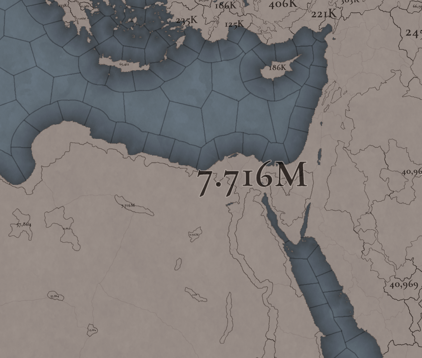
The population of the region points to Egypt being its powerhouse, with several million people being supported being the Nile Valley and Delta. Apart from that, the Syrian Levant has a very decent population, making the Mamlūk Sultanate a dreadful rival to have in 1337. The arid fringes make for a way more difficult food production and population sustainability, making them more of strategic value, by their position, resources, etc.

And that’s all for today! Next week @Johan will show you Scandinavia, the very first map that was crafted for Project Caesar! Cheers!
 
  • 176Like
  • 54Love
  • 7
  • 4
  • 4
  • 1Haha
Reactions:
I'm working today on a laptop, and won't be able to make a better screenshot. I can provide you with a list of provinces, though:
  1. Al Buhayra
  2. Al Gharbiyya
  3. Ash Sharqiyya
  4. Cairo
  5. El Minya
  6. Asyut
  7. Aswan

Thank you for the names and thank you very much for this very detailed Tinto talk on one of the more controversial regions. Great work on the cultures and religions. While I still need some time to look into the sources (e.g. Ibn Mammati) to get a better view of the Egyptian locations in that time, I already have a few suggestions.

1- Naming inconsistencies
a) El/Al inconsistency
In Egyptian Arabic, the definite article is EL, never Al. You have this correctly in the names of the locations El Mahalla, El Burullus, El Bahnasa, El Qasr, El Arish, El Qoseir, and El Tor as well as the province of El Minya. You however used the standard Arabic variety "Al" in some other location names for no apparent historical, regional, or linguistic reason. For example, the locations Al Buwit, Al-Balyana, Al Jundi, and the provinces Al Buhayra, Al Gharbiyya, Ash Sharqiya, and Al Jifar. Here I would recommend using the Egyptian Arabic variant of El, since these are Egyptian location names.

b) The hyphen after El/Al
Al-Balyana has a hyphen after the definite article. I suggest removing the hyphen and going with El Balyana.

c) Inconsistencies in the use of the definite article in location and province names.
Why is it El Bahnasa and Al Jifar but Faiyum and Tih, rather than El Faiyum and El Tih? There is no reason to choose one over the other, as both have the El in their Egyptian Arabic names. Some other names that should have El in their names drop it, such as El Bahariyya (meaning the northern [oasis]) drops to Bahariya. In another case, you have the location as Minya but the province as El Minya. My suggestion is to keep the El in the localization to Arabic-speaking ruling countries like with Welsh names and remove it for English and other Western languages since the definite article in the location name doesn't make sense in most place names in those languages (The London?). An Egyptian when switching to English will intuitively drop the El from the location names. "I went to Bahnasa" sounds more natural than "I went to El Bahnasa". Also, the official English names of modern Egyptian governorates drop the El. For example, what you have as Ash-Sharqiyya province is officially Sharqiya Governorate. I don't know about other varieties of Arabic, Egyptian Arabic is my native language. Another option is to just add El everywhere, but then you will have to add it to a few more location names.

d) Al Sharqiyya vs Ash-Sharqiyya
Do you want to go down the rabbit hole of Arabic sun and moon letters? Again I suggest dropping the article altogether.

e) Y-consonant gemination inconsistensies
Ash-Sharqiyya vs Bahariya .. pick one. In both standard and Egyptian Arabic, the Y is geminated and pronounced Sharqiyya and Bahariyya.

f) Egyptian Localization
Saint Anthony is Anba Antonios, Saint Katherine is Sant Katrin, Ras Gharib is Ras Ghareb, Hauf Ramsis is Hof Ramsis. Al Buhaira is El Beheira.

If you also need Coptic localization for the location names for some alternate history Coptic cultural revival plays, I am sure there are many Egyptians who can help you with that, including me.

2- Regions/Provinces Divisions
a) Upper and Lower Egypt
- Minya/ El Minya is definitely Upper Egypt, not Lower Egypt.
- Red Sea Cost has more cultural ties to Upper Egypt not Lower Egypt (check geography section).

b) Alexandria
- Alexandria was never part of "Al Buhayra/El Beheira", nor did it have many cultural or linguistic ties with it. II quickly checked Mamluk and Fatimid sources and this simply never happened.
- Matruh and Sallum were never under the administration of Cyranaeca/Barqa for any significant period of time.
The only division that makes sense here would be to remove Alexandria from "Al Buhayra/El Beheira" and create a new province including Alexandria, Matruh and Sallum, and call it Alexandria. Long Alexandria > Long Barqa, having basically Libya snake all the way to the edge of the Nile Delta doesn't make any sense.

3- Geography
You are missing two desert/mountain passes between Upper Egypt and the Red Sea. from Tabnah to Ras Ghareb and from Sharuna or Atfih to Saint Anthony. Mining and trading campaigns since ancient times have crossed from Upper Egypt through the wadis of the eastern desert to the Red Sea, not all the way north to the delta then to Suez, and finally down the coast.


4- Cultures
I know you based the names Egyptian, Sa'idi, and Coptic on the English Wikipedia names of the languages/dialects spoken by these groups, which is fine. But may I suggest that you change Egyptian and Sa'idi to Lower Egyptian and Upper Egyptian? Sa'idi literally means upper, referring to Upper Egypt, and while it is almost never used in modern times, Upper Egyptians aka "Sa'idis" would refer to Lower Egyptians as Bahrawy (Northerner). During Mamluk/Ottoman rule and until the monarchy was abolished what you call Egyptian was referred to historically as Fellah (pl. Fellahin literally meaning peasant), but you don't call it Bahrawy or Fellahin culture, you call it Egyptian as if it were the default culture. The cultural and linguistic divide between the two cultures clearly follows the geographical divide between Upper and Lower Egypt and predates the Arab conquest. It has existed from pre-dynastic through Coptic Egypt to the present time. Picking one as the de facto standard Egyptian is quite biased in my opinion, and I am not from Upper Egypt, by the way.

5- Resources
Sinai is probably named after the mineral turquoise because of the abundance of turquoise mines there. I don't think turquoise is a resource in the game, but maybe dyes instead of stone next to the copper province in South Sinai could be a good addition.


Overall you have the best most accurate representation of Egypt in any video game ever and I can't praise you enough for that. I know for a fact that you based this on solid sources. Thank you for your work.
 
  • 11Like
  • 2
  • 1Love
  • 1
Reactions:
I dont know man, I think you people are completely oblivious to what kind of game you're planning to play here. Maybe it's the hugboxing atmosphere of this forum, IDK

That argument, btw (let's represent something unimportant because that's happened IRL without worrying whether it can be realistically represented with game mechanics without breaking the existing ones) is what has yielded eu4 things like australian tribes with standing fleets, missionaries and diplomats, native american tribes westernizing into european style principialities within 50 years of game time, and so many other thigns that has just made the game, in that specific region at least, worse, and worse, and worse.

IDK, is it naïveté? Lack of experience with the genre? Something else? Probably all of those things
I don’t what you’re trying to say, think you’re being a bit of an asshole, but the devs spend their whole time on this forum discerning truth and substance, they’ve obv gotten pretty good at it. It’s more important this forum’s welcoming and a nice place so they get more feedback which ultimately makes the game better
 
  • 3Like
Reactions:
Not sure if someone pointed this out already but I'd like to suggest some fixes in Palestine.
First of all, as others have said, the locations in Palestine should be named with endonyms if the rest of the Arab world also has endonyms.
I understand that the devs are working on a dynamic endonym system, and if so then that's fine.

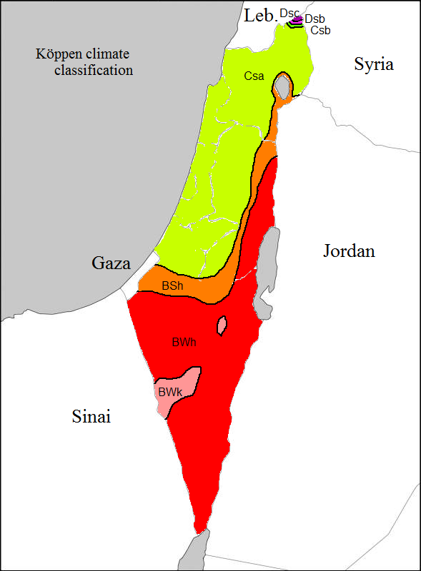
The area in Hebron that is next to the Dead Sea is arid and should definitely not be a woody source of lumber - in modern times it is given the Koppen classification of BWh, which is a desert:

map_of_Köppen_classification.png

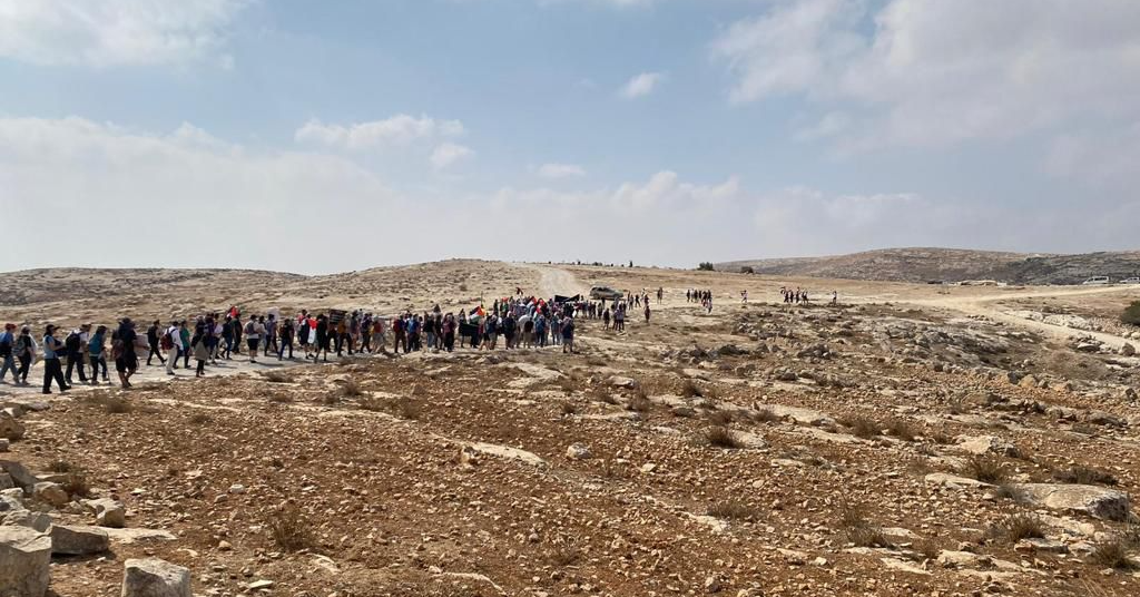
This is how the area around Hebron looks today:
hebron.png


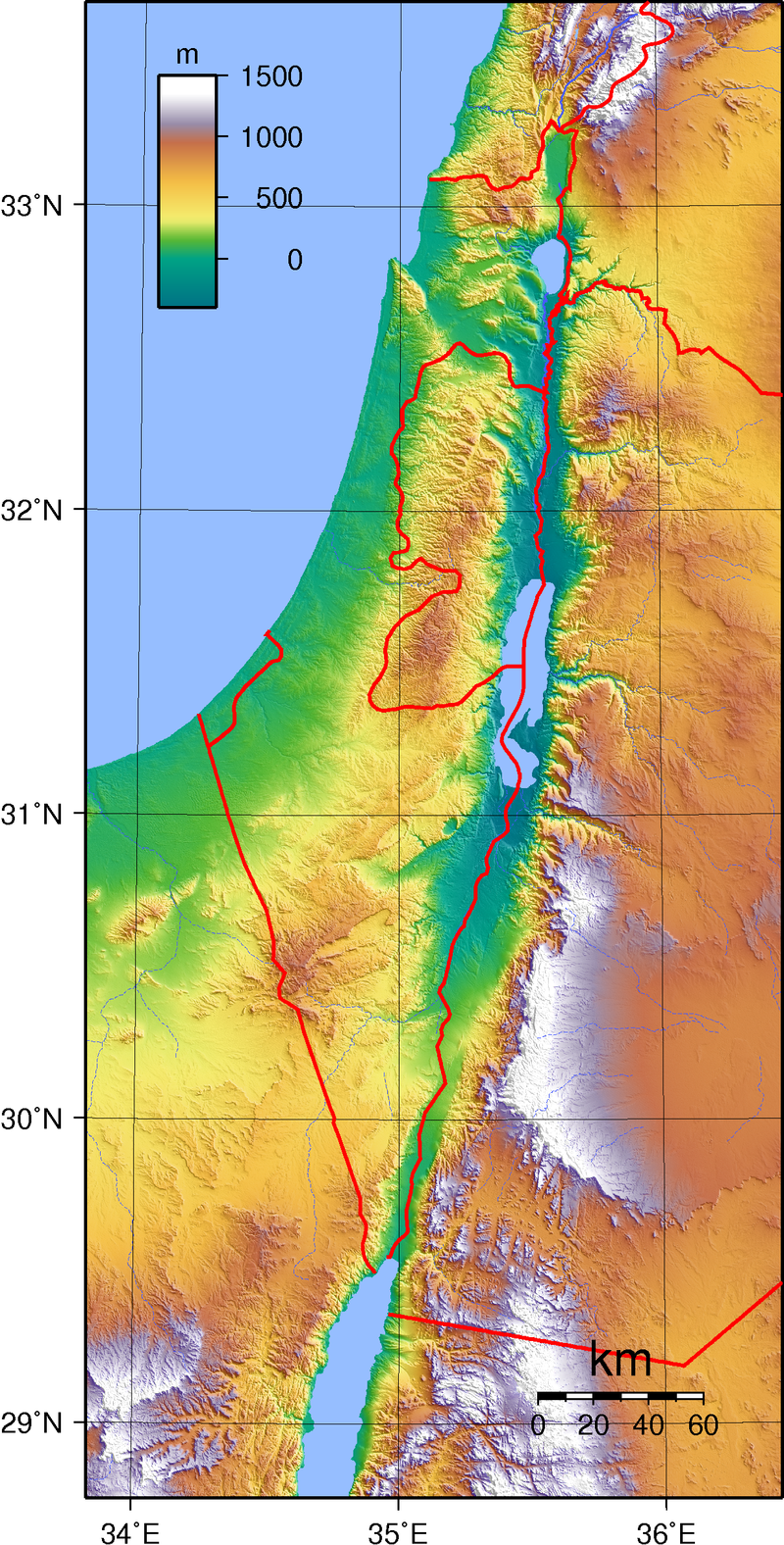
The 'hills' terrain in Palestine also doesn't align with reality - the hills should extend from Hebron all the way to Safed, but not in the coast, which is indeed a flatland:
800px-Israel_Topography.png

As is clear from this map, the areas around Nablus and Safed - the northern West Bank and the Galilee respectively - are very hilly places as is indicated by the patches of yellow, green and red there.

I appreciate the devs inserting lumber as a resource in Palestine but it is in the wrong location. Before WW1 there were oak forests in Palestine, particularly in an area spanning from the Yarkon river near Jaffa to the Carmel, depicted as part of 'Acre' here. The Crusaders knew it as "The Forest" or the "Arsuf forest" as the fort of Arsuf/Apollonia was surrounded by that forest. The rest of Palestine also used to have considerably more trees than today. The Ottomans cut down Palestine's trees as lumber and imposed taxes on trees that grew on private lands in Palestine. Eventually this and Palestine's role as the Ottoman-British front during WW1, during which the Ottomans cut down massive amounts of trees in Palestine to make charcoal for mobilizing their troops, led to deforestation. Despite modern reforestation efforts those oak forests are largely gone today. You could expect the northern parts of Palestine to be more woody in the 1300s, but not Hebron, which has a more barren climate overall.
To sum up, any lumber in Palestine would be only from 'Acre' and not from 'Hebron'.

An interesting choice could also be to have Jerusalem produce wine - wine production by Christian communities in the Judean hills (around Jerusalem and Bethlehem) was well attested. However, as the Christian population there gradually converted to Islam during Mamluk rule wine production was gradually replaced with olives.
Obviously Palestine should have a very substantial minority of (Arab) Levantine Christians - roughly half of whom would be Orthodox and the rest Catholic and of other denominations (some Miaphysites). Many of them converted to Islam during the Mamluk period due to the efforts of Sufi mystics.

Beside that, the location of Al-Majdal (north of Gaza, in Palestine) has more population than it should. Before modern Zionist settlement this area was rural, undeveloped and devoid of major cities (Al-Majdal itself, modern day Ascalon, was no more than a village when compared with other population centers in Palestine, and the largest population centers in that area were Jaffa and al-Ramlah rather than Majdal itself). Given this situation Majdal should have way less population in game than neighboring Gaza, Acre and Nablus. Nablus is where the Samaritan minority should be (even their name hints to this - 'Samaria' being the ancient name for the area called 'Nablus' in the screenshots), and any Jewish minority should also not be in Al-Majdal.

The Samaritans were treated very poorly by the Mamluks, who did not consider them to be "people of the book" (unlike Jews and Christians) and forced them to convert. During the Mamlukean period the Samaritan community was almost made extinct, with some 15th century estimates numbering them no more than 500 people as a result of this persecution, and they remain a tiny community to this day.

The Jewish population in Palestine wasn't very large in this period at all, especially given how many were forced to flee to Egypt during the Crusades (and the Jewish community in Egypt was much bigger than the one in Palestine anyway). We know in particular from comments of Jewish travellers of that period that there were little to no Jews in Jerusalem, even though the Mamluks did allow Jews to live there. Famously, there were many Jews in Safed and Tiberias (Safed even had a Jewish majority for a time), but most of them were Sefardic Jews who were invited there by Ottoman officials, and in the 14th century the Jewish population there would be small. Beside Safed, another place I could concieve of having a Jewish minority would actually be Gaza - Italian travellers in the Levant in the late 14th century described a Jewish minority in Gaza, most likely a community that fled to Egypt when Gaza was destroyed during the First Crusade and then returned under the Mamluks. The Jewish community in Gaza is ancient and long-attested, and famously the 17th century messianic claimant Sabbatai Zevi had a lot of support from the Jewish community in Gaza.

Much larger Jewish communities existed at the time in Egypt, Baghdad and Damascus (and there were also sizable Karaite communities in those places - Karaism should definitely be separate from Rabbinical Judaism as during the timescale of the game there are Karaite communities that deviate very significantly from standard Judaism and are treated differently by the authorities, like the ones in Crimea). Even the Jewish communities in Persia and Bukhara would be bigger than the one in Palestine.
That being said, the population of Palestine is small in general at this period, largely as a result of the Mamluk sultan Baybars destroying almost all coastal towns in Palestine to prevent the Crusaders from reconquering them. Ascalon, Jaffa, Haifa and Acre were desolate during the ENTIRE Mamluk period and the latter three were rebuilt by the Ottomans. Safed and Gaza were the most important cities in Palestine alongside Jerusalem and so that's where the bulk of the population and minorities should be.

So I'd suggest the following:
  • The locations of Jerusalem, Nablus and Safed should be hilly and woody, and Hebron should have sparse vegetation.
  • Much of the population placed in Al-Majdal should be moved to Gaza, Nablus and Safed along with any minorities there.
  • As for production, have olives/wine in Jerusalem and livestock/wool in Hebron.
  • And it would be nice to represent in some way that the coastal towns of Palestine have been destroyed by the Mamluks, so it has no ports or fisheries, apart from Gaza.
 
Last edited:
  • 9
  • 7Like
  • 1
Reactions:
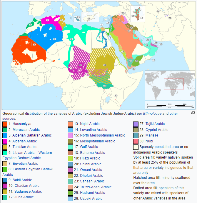
I would merge Najdi with Bedouin, rename Egyptian to Masri, rename Eastern Berber to Fezzani and rename Alawite to Nusayri. I think Alawites, Karaites and Sabbateans need their own religion too. Other than that, seems mostly fine. Crete and Cyprus should start out as Greek IMO. Also Libyan should be Tripolitanian in my opinion.
I agree it makes no sense having Najdi and Bedouin as separate cultures, either merge them or divide Bedouin up into Lower Egyptian, Levantine and Hejazi (I would prefer the latter one imo).
I think they're basing their Arab subdivsions on this (inaccurate) modern-day map of Arabic dialects on Wikipedia and assumed that Eastern Egyptian Bedawi included all Bedouins.

1720870763967.png


As for Sabbateans, I love me some 17th century millenarian cults as much as the next guy (King Sebastian will come back one day! I know it!), but they never really went anywhere. Their biggest impact were the Dönmeh community of Turkey.
If the devs ever decide to make some sort of event chain for the Sabbateans, more power to them though, it could be fun to defeat the dragon and become the new dragon.

Why is Hejazi named as the transliterated endonym? Every other culture is the English exonym, and it's odd that Hejazi is an exception.
The inconsistency with Arabic bothers me a bit. Where is the line between an adapted and unadapted loanword? Why's it "Shia Islam" and not "Šīʿa Islām" but "Mamlūk" and not "Mameluke"?
 
Last edited:
  • 6
  • 2
Reactions:
I want to argue that, for actuality's sake, it hasn't to be the case with the Coptic population at all! Of course, there are other groups which would be much more strictly ethnoreligious than the Copts (most Jewish diaspora cultures come to mind), but, differently from what has been said by some in the thread, conversion doesn't come necessarily before cultural assimilation, and Egypt historically has been a particularly notable counter-case.

I defer both to Coptic Conversion and the Islamization of Egypt and The Transition from Coptic to Arabic concerning this phenomena: Partially due to the widespread settlement of arab tribesmen in Egypt ever since the conquest (because, well, fertile land, and garrisoning purposes), and partially due to the integration of the Coptic elites into the mainly Arabic-speaking bureaucracy during the Fatimid period, an increasing amount of the Coptic – well, not only Coptic, all Christians were involved to some extent – population, in a top-down process, started to integrate the Arabic language in their lives, and soon quite the lot of native egyptians were being raised as native Arabic speakers without ever considering conversion, the current extent of the Coptic religious population is also the long-term attestation of this, they've been native speakers of Arabic for centuries by this point, but they're still Christians.

The point is that, the whole "well, what happens to a Coptic pop that converts to Islam?" (Or vice-versa) conundrum can be solved by reframing what the game represents by the Coptic culture itself. It can work like that: "Coptic" pops represent people that, beyond everything, still speak Coptic colloquially, and sure, by game-start, all Coptic pops are Miaphysite, but not all (well, maybe not even most) Miaphysite pops are Coptic, with already-Arabized – but still Christian – populations, being represented by Masri/Sa'idi pops that are of Miaphysite faith. I don't know how that could be modelled in-game, but something that makes it more likely for a Coptic pop convert to the surrounding Arabic equivalent BEFORE that pop converting religions should be sufficient (and, i guess, much easier than simply modelling actual ethnoreligiosity) for it to model not only the historical decline of the Coptic language in-game (PC in a 1800 start-date would have no Coptic culture pops, but still a relevant amount of Miaphysite Egyptian pops) vis-a-vis the non-conversion of Copts to Islam, but also if implemented elsewhere could allow events like the historical Arabization of Sudan, the Turkification of some christian populations under Ottoman rule and many other particular cases to play out historically if enough conditions were met!

Unrelated but, i'm missing any Miaphysite pops in Syria representing Syriac Orthodox (Antioch/Jacobites) populations. I can see some stripes here and there but the colors (and the number of minorities, lol) don't help a lot, even with that, i think that Mardin (the seat of the Church in the entirety of the game's timeframe!) should be dominantly Miaphysite, at least, and there should be considerable minorities in Aleppo, Damascus (i can't quite figure out if there already are, if there is, just ignore this part) and Homs.
Coptic was virtually dead as a language if not completely dead by 1337, a Coptic culture for the Myaphiste Arabic speakers in 1337 is fine IMO
 
  • 6
Reactions:
Coptic was virtually dead as a language if not completely dead by 1337, a Coptic culture for the Myaphiste Arabic speakers in 1337 is fine IMO
You say that based on what? There's reports of people still using it as a native language as late as the 19th century in Upper Egypt (by Egyptologist James Quibell and by Werner Vycichl on Popular Traditions of the Coptic Language, who mentioned two villages named az-Zaniyah/pi-Solsel where old-age passive-speakers could be found), while at the very very least it certainly survived to the 17th century, when german traveler Johann Michael Vansleb attested to the death of an old man speaking in Coptic (he funnily concluded at such a sight that with that man's death, "Coptic will die", although on interpretation he may've been referring to that man's Coptic specifically).

Besides that, by 1337 there has been not even two full-centuries since Arabic took over as the Church's (and therefore the Coptic elites') main language of literature, and in a pre-industrial society, especially a very peasant-heavy one like Egypt, literature is often dissonant to the main demographically-relevant language. A lot of (religiously) Copts have Arabic as their native language in 1337, but not (even near) the extent of the language being sentenced to death, especially in Upper Egypt, where Sahidic literature kept flourishing until the Ottoman period.

Edit: I also think that a Coptic culture for Miaphysites would be OK, the thing is that Pavía stated that it's hard to game-conceptualize ethnoreligious pops, so the best way to correct the problem would be to separate the ethnos from the religion as much as possible, elsewise anything would result in game-y situations that by the way Tinto has carried the game so far, they would wish to rather avoid.
 
Last edited:
  • 3
  • 1
Reactions:
You say that based on what? There's reports of people still using it as a native language as late as the 19th century in Upper Egypt (by Egyptologist James Quibell and by Werner Vycichl on Popular Traditions of the Coptic Language, who mentioned two villages named az-Zaniyah/pi-Solsel where old-age passive-speakers could be found), while at the very very least it certainly survived to the 17th century, when german traveler Johann Michael Vansleb attested to the death of an old man speaking in Coptic (he funnily concluded at such a sight that with that man's death, "Coptic will die", although on interpretation he may've been referring to that man's Coptic specifically).

Besides that, by 1337 there has been not even two full-centuries since Arabic took over as the Church's (and therefore the Coptic elites') main language of literature, and in a pre-industrial society, especially a very peasant-heavy one like Egypt, literature is often dissonant to the main demographically-relevant language. A lot of (religiously) Copts have Arabic as their native language in 1337, but not (even near) the extent of the language being sentenced to death, especially in Upper Egypt, where Sahidic literature kept flourishing until the Ottoman period.

Edit: I also think that a Coptic culture for Miaphysites would be OK, the thing is that Pavía stated that it's hard to game-conceptualize ethnoreligious pops, so the best way to correct the problem would be to separate the ethnos from the religion as much as possible, elsewise anything would result in game-y situations that by the way Tinto has carried the game so far, they would wish to rather avoid.

"For the transition from Coptic to Arabic, this second phase is, no doubt, the crucial one. While Coptic is well represented in the papyri until the mid-eleventh century, there is almost nothing in Coptic after the year 1200 23. Taking into account the fact that we have three major collections, one historiographic, one dogmatic and one canonical, produced in Arabic on the basis of Coptic sources within the last three decades of the eleventh century, it is even possible to narrow down the most important period to these years. It seems Mawhûb and Habib Mikhâ'il were not alone searching the monasteries for manuscripts and translating and editing collections of remaining value. Their translations, as well as many others were, moreover, not made ad hoc and not on simple private initiative, but officially sanctioned by the Church. Except for the Synaxarium and the revised canonical collection by Macarius, belonging to the third phase, there were to be no more comparable works of translation. To a large extent it seems to have been the collectors, translators and editors of the time of Christodolus II (1047-1077) and Cyril 11 (1078-1092) who geared the transition from Coptic to Arabic.It seems, moreover, that these two patriarchs, who both belong to the most prominent in the historyof the Coptic Church, played a major role in the linguistic shift."

"The third period is the one best known and best recorded in our manuscripts. By now, Coptic had ceased to be a living language, and thus translations had become restricted to a limited number of scholars and monks who were willing to study their old language 24."

After 1200 Coptic acted basically as Latin, maybe a few isolated communities spoke it but it doesn't seem to have been even 10% of the Coptic community, maybe even less than that. I personally don't think isolated unverifiable accounts can be used to argue against the contemporary 12th and 13th century evidence of Coptic essentially having become a purely liturgical language.
 
  • 2
  • 1
Reactions:

"For the transition from Coptic to Arabic, this second phase is, no doubt, the crucial one. While Coptic is well represented in the papyri until the mid-eleventh century, there is almost nothing in Coptic after the year 1200 23. Taking into account the fact that we have three major collections, one historiographic, one dogmatic and one canonical, produced in Arabic on the basis of Coptic sources within the last three decades of the eleventh century, it is even possible to narrow down the most important period to these years. It seems Mawhûb and Habib Mikhâ'il were not alone searching the monasteries for manuscripts and translating and editing collections of remaining value. Their translations, as well as many others were, moreover, not made ad hoc and not on simple private initiative, but officially sanctioned by the Church. Except for the Synaxarium and the revised canonical collection by Macarius, belonging to the third phase, there were to be no more comparable works of translation. To a large extent it seems to have been the collectors, translators and editors of the time of Christodolus II (1047-1077) and Cyril 11 (1078-1092) who geared the transition from Coptic to Arabic.It seems, moreover, that these two patriarchs, who both belong to the most prominent in the historyof the Coptic Church, played a major role in the linguistic shift."

"The third period is the one best known and best recorded in our manuscripts. By now, Coptic had ceased to be a living language, and thus translations had become restricted to a limited number of scholars and monks who were willing to study their old language 24."

After 1200 Coptic acted basically as Latin, maybe a few isolated communities spoke it but it doesn't seem to have been even 10% of the Coptic community, maybe even less than that. I personally don't think isolated unverifiable accounts can be used to argue against the contemporary 12th and 13th century evidence of Coptic essentially having become a purely liturgical language.
That paper is talking about literary language. Spoken Coptic was used by different communities in Upper Egypt until 19th century, as attested by various people who encountered them.
 
  • 3
  • 2Like
  • 1
Reactions:
I don't know much about the region, so my suggestions are pretty generic:
1. I think you should really split up the Saharan wastelands so that they look nicer when coloured-in. Right now those borders of Upper Egypt are killing me.
2. I feel like it would be more appropriate to rename "Miaphysitism" into "Oriental Orthodoxy", since that's what their religion is called; "miaphysite" just describes their preferred Bible headcanon theology. That may be confusing to players unfamiliar with history, but I don't think that's the target demographic for PDX games.
3. The raw goods' colours are still kinda awful. The biggest offenders here are fish, which is too greenish, blending in with beans/legumes, as well as dates - those sweet sweet fruits have the same colour as sand. Fish should be more light blue and dates should be red-orange-brownish more like the actual thing.

I also have two questions the answer to which might be turned into a suggestion:
1. What is the reason for the existance of Sinai as a separate area? Why is Sinai it's own area while places like Palestine or Syria are not? I think it would make sense for Sinai to be a part of Levant, unless there's some game design rationale behind it being that way.
2. Some of the oases are owned by a country called "Fezzan", but it doesn't seem like "Fezzan" was ever a separate country, just the name of the region. I assume it's a placeholder country before the Maghreb TT (since EU4 also had a country called Fezzan), but maybe I'm just stupid and couldn't find the proper information about it.
 
  • 3
  • 1
  • 1
Reactions:
That paper is talking about literary language. Spoken Coptic was used by different communities in Upper Egypt until 19th century, as attested by various people who encountered them.
It is talking about both, please read it properly before replying

"The Church had to adapt to the fact that the Christians were no longer able to read or understand-Coptic."

"The third period is the one best known and best recorded in our manuscripts. By now, Coptic had ceased to be a living language, and thus translations had become restricted to a limited number of scholars and monks who were willing to study their old language 24."

If the author meant it stopped being a "living literary language" this sentence would make no sense, it is clearly talking about it dying as a spoken language, otherwise why would only a "limited number" of people be able to produce translations only after studying the language that Copts supposedly could still speak?

"When Arabic had finally and by necessity, become a language acceptable to the Church, there was little to preserve Coptic. Once the-process started in the late ninth century it took only a few generations before Arabic replaced Coptic as the most important language of the Christians."
 
  • 1
Reactions:
i added 3 locations
1. Jaffa- flatland, woods, wheat as raw material
2. Nazareth- hills, woods,wheat raw as material
3. Jericho- hills,desert,sulfur as raw material
about existing locations Safed would be better as mountains
Acre would be better as mountains as well and have fish as raw material, Sughar should have copper as raw material and Jerusalem should be mountains and have olives as raw material
View attachment 1162483
Your location map is unfortunately confusing but a couple of notes -
Jericho is a good idea, though the location should not stretch all the way to Sughar and should eat into Nablus and Jerusalem a bit more
Jenin would be a better choice over Nazareth. Nazareth at this point had been massively depopulated by the Mamluks because "Crusaders bad, Christians bad" and for several following centuries was nothing more than a village. Jenin on the other hand remained a popular stop between Cairo and Damascus and was a market center for the surrounding area.
 
  • 3
  • 1Like
  • 1
Reactions:
It is talking about both, please read it properly before replying

"The Church had to adapt to the fact that the Christians were no longer able to read or understand-Coptic."

"The third period is the one best known and best recorded in our manuscripts. By now, Coptic had ceased to be a living language, and thus translations had become restricted to a limited number of scholars and monks who were willing to study their old language 24."

If the author meant it stopped being a "living literary language" this sentence would make no sense, it is clearly talking about it dying as a spoken language, otherwise why would only a "limited number" of people be able to produce translations only after studying the language that Copts supposedly could still speak?

"When Arabic had finally and by necessity, become a language acceptable to the Church, there was little to preserve Coptic. Once the-process started in the late ninth century it took only a few generations before Arabic replaced Coptic as the most important language of the Christians."
And those statements are based on the analysis of literary texts.

I'm not saying that Coptic was widespread in Egypt, but statements it was completely dead are just not true. It survived in various - to large extent isolated - communities, as attested mostly by egyptologists who encountered them when traveling in then isolated places in Upper Egypt (today some of these are popular tourist areas).
 
  • 5
Reactions:
And those statements are based on the analysis of literary texts.

I'm not saying that Coptic was widespread in Egypt, but statements it was completely dead are just not true. It survived in various - to large extent isolated - communities, as attested mostly by egyptologists who encountered them when traveling in then isolated places in Upper Egypt (today some of these are popular tourist areas).
These accounts could have been true even in 0.1% of Copts in Egypt spoke the language in 1337, so it doesn't really matter much. I also explicitly said "virtually dead", so this nitpicking is pointless. It doesn't matter if it was 0.1%, 1% or even 5%, the point is the vast majortiy of Copts had no knowledge of Coptic by this point in time and spoke the same kind of Arabic Muslims did.
 
  • 2
Reactions:
Coptic was virtually dead as a language if not completely dead by 1337, a Coptic culture for the Myaphiste Arabic speakers in 1337 is fine IMO
And those statements are based on the analysis of literary texts.

I'm not saying that Coptic was widespread in Egypt, but statements it was completely dead are just not true. It survived in various - to large extent isolated - communities, as attested mostly by egyptologists who encountered them when traveling in then isolated places in Upper Egypt (today some of these are popular tourist areas).
We don't know exactly when Coptic died as a spoken language. For this reason, you can't really use it to describe only un-Arabized Copts. Either you use it to represent all Copts or get rid of it as a culture and represent Copts as just Upper/Lower Egyptians with Miaphysite religion, the former seems to be what Tinto went for.

I don't know much about the region, so my suggestions are pretty generic:
1. I think you should really split up the Saharan wastelands so that they look nicer when coloured-in. Right now those borders of Upper Egypt are killing me.
2. I feel like it would be more appropriate to rename "Miaphysitism" into "Oriental Orthodoxy", since that's what their religion is called; "miaphysite" just describes their preferred Bible headcanon theology. That may be confusing to players unfamiliar with history, but I don't think that's the target demographic for PDX games.
3. The raw goods' colours are still kinda awful. The biggest offenders here are fish, which is too greenish, blending in with beans/legumes, as well as dates - those sweet sweet fruits have the same colour as sand. Fish should be more light blue and dates should be red-orange-brownish more like the actual thing.

I also have two questions the answer to which might be turned into a suggestion:
1. What is the reason for the existance of Sinai as a separate area? Why is Sinai it's own area while places like Palestine or Syria are not? I think it would make sense for Sinai to be a part of Levant, unless there's some game design rationale behind it being that way.
2. Some of the oases are owned by a country called "Fezzan", but it doesn't seem like "Fezzan" was ever a separate country, just the name of the region. I assume it's a placeholder country before the Maghreb TT (since EU4 also had a country called Fezzan), but maybe I'm just stupid and couldn't find the proper information about it.
"Miaphysite" is the least cumbersome option for naming, as stated, and it's not like an insult or exonym or anything, Oriental Orthodox people identify with the term today, it's just not used in the official title of any Oriental Orthodox church.

I agree that the Sinai Region should be split between Lower Egypt and the Levant/Hejaz.
 
Last edited:
  • 2Like
  • 1
Reactions:
Hello everyone, and welcome to another Tinto Maps! We’re back after celebrating the most important victories over Germany and France since the 30 Years War a hard week of work, and we’re ready to share with you the region of the Syrian Levant & Egypt (actually, we’re revealing a bit more of what those regions would be, to cover the complete extension of the Mamlūk Sultanate). Let’s go!

Countries:
View attachment 1161740
The Mamlūk Sultanate is the main power of the region, a situation achieved after the defeat of the Mongols at the Battles of Ain Jalut and Marj al-Saffar, and the fall of Acre, the last stronghold of the Crusader states in Outremer. The latter's legacy is still handled by the Kingdom of Cyprus, ruled by Hugues IV of Lusignan. Apart from that, we can see the realm of Candia, a subject governed by the Serene Republic of Venice, and some Arabic tribes, such as the Hutaym and the Anizah. Oh, and also, to the south-west, you might have noticed some oases ruled by either the Mamluks, or Fezzan; I opted for not coloring the wastelands, as usual, but also the corridors, a type of terrain present in other GSGs, that we have in Project Caesar. I’ll talk more about them under the ‘Locations’ section of the DD, but I just want to note one more thing: the connection down the Nile is a regular one, with a border existing between the Mamluks and Makuria (the country that controls the small chunk of land at the very south of the image).

Dynasties:
View attachment 1161741
The Bahri Mamluks have ruled the Sultanate since they deposed the Ayyubids, almost a century before the start of the game. It could maybe be a bit more accurate to depict Sultan al-Nasir Muhammad as an ibn Qalawun (‘of the lineage of Qalawun’), but the dynastical dynamics of the Mamluk rulers are not so easy to portray, so we opted for the moment to better use Bahriyya. Apart from that, you may also see the neighboring dynasties, such as the already-mentioned House of Lusignan, or the Hethumian of Cilicia.

Locations:
View attachment 1161743
Here you can see the locations of the entire region, and also closer chunks behind the ‘Spoiler’ button. The most interesting feature to talk about is that of the corridors, something that some of you might remember from ‘Imperator: Rome’, but also something new to the rest. The corridors are empty locations, with no population or resources, but that allows connection between the locations at their sides, for some mechanics that we’ve already mentioned (market access, control), and some others that we haven’t (army movement). This is the way that we’ve chosen to portray the Saharan corridors, that allow for a connection between the Maghreb and the Mashreq, and Western and Central Africa. There are also some regular locations over those corridors, with population, resources, etc., that can be controlled by countries, which portray the desert oases that made for important outposts in the different Saharan routes. Not all the connections are throughout corridors, though; outside of the image, the Nile River valley allows for regular locations all the way down from Egypt to Nubia, the last location held by the Mamluks being that of Aswan, while the first held by Makuria, not shown in the screenshot, being Qasr Ibrim. We will talk more about Nubia and Ethiopia in a future Tinto Maps.

Provinces:
View attachment 1161747
Usual provinces mapmode; please let us know of any spelling or naming suggestions that come to your mind.

Areas:
View attachment 1161749
A new mapmode that has been requested in previous Tinto Maps, and that we’re now incorporating.

Terrain:
View attachment 1161750
View attachment 1161751
View attachment 1161752
The climate is dominated by a mix of Mediterranean, Arid, and Cold Arid. The topography of the region is quite flat, with some hills and mountains on Mount Lebanon and Anti-Lebanon, Mount Sinai, and the verge of the Arabian plateau; and some marshland over the Nile Delta, of course. Regarding the vegetation, desert and sparse vegetation dominate most of the region, with some woods and forests over Levant, and the Nile fertile farmlands, the bread basket of the Eastern Mediterranean.

Cultures:
View attachment 1161753
Here starts the fun… Those countries ruling over the Middle East will face the challenge of managing several different cultural minorities. Libyan, Egyptian, Sa'idi, Bedouin, Ḥijāzī, Najidi (the green one to their right), Levantine, and Iraqi (the light blue at the top right of the picture) are all different regional cultures of Arabic-speaking people. Something interesting is that most of Bedouin pops are tribesmen, instead of peasants, portraying their traditional social organization. Coming to important minority groups, Coptic people are quite important in Egypt, accounting for about 10% of the population of the Mamlūk Sultanate. The other important minority are the Syriacs, as they also account for another 10% of the population, and are a cultural majority in a few locations. Apart from those, there are also Armenians, Kurds, and Turkomans on the divide between Anatolia, Syria, and Jazira, Alawites Shiites in Syria, Mizrahi Jews all over the region, Samaritans in Palestine, and Greeks in Crete, Cyprus, and some in Alexandria. Oh, also the Saharan cultures of the Eastern Berbers and the Toubou over some of the Saharan oases.

Religions:
View attachment 1161754
More fun. In this region, we have:
  • Sunni Muslims
  • Miaphysite Christians
  • Orthodox Christians
  • Shia Muslims
  • Catholic Christians
  • Druzes
  • Jews
  • Nestorian Christians (the ‘label’ we’re using to depict the Church of the East)
  • Samaritans
  • Yazidi

Relating these religions to the previous cultures, we can tell you most of the Arabic-speaking cultures are Sunni Muslims, with some Shia Muslims in Syria and Lebanon. Most of the Coptic are Miaphysite, adhering to the Patriarchate of Alexandria, although some of there still follow the Orthodoxy of Constantinople. The Syriacs are also religiously divided, with some being Nestorians (the current name we have to cover the confessions related to the Church of the East), some Miaphysites, some Orthodox, and even some Catholics in Lebanon. And then we have some cultural-religious minorities, such as the Alawite Shiites, the Druzes (which are of Levantine culture), the Mizrahi Jews, the Samaritans, and the Yazidi (which are of Kurd culture).

Raw Materials:
View attachment 1161755
There are some materials that are more unique to this region, such as the Dates in the arid fringes. The Nile Valley and Delta are incredibly fertile, having plenty of different crops: Wheat, Rice, Legumes, Sugar, Cotton, Fiber Crops (=Linen), etc. Livestock, Wool, and Horses are also important resources for the people across the region. There are also some metals present in the region, such as Copper in Cyprus and around the Red Sea, Iron, Tin, some Lead, and some interesting sources of Alum.

Markets:
View attachment 1161756
The main market centers of the region are Alexandria (yeah, it’s there! I’ve already reported its weird name-wrapping and one of our programmers is going to take a look at it) for the Mashreq, Damascus for the Syrian Levant and Mecca for the Hejaz.

Country and Location Population:
View attachment 1161757
The population of the region points to Egypt being its powerhouse, with several million people being supported being the Nile Valley and Delta. Apart from that, the Syrian Levant has a very decent population, making the Mamlūk Sultanate a dreadful rival to have in 1337. The arid fringes make for a way more difficult food production and population sustainability, making them more of strategic value, by their position, resources, etc.

And that’s all for today! Next week @Johan will show you Scandinavia, the very first map that was crafted for Project Caesar! Cheers!
When would we get to the maps outside of Europe? Very curious about the Far East region as it's often underrepresented and dwarfed in density to europe, which feel like cheating.
 
  • 1
Reactions: