• We have updated our Community Code of Conduct. Please read through the new rules for the forum that are an integral part of Paradox Interactive’s User Agreement.

Tinto Maps #14 - 9th of August 2024 - Western Africa

Hello, and welcome one more week to Tinto Maps, the day of the week for map nerds lovers! This week we will be taking a look at Western Africa! These lands were named historically in different ways, although probably the most widespread naming was Guinea, which also names the Gulf that makes for the southern limit of the region, with the Atlantic Ocean being to the west, the Sahara desert to the north, and the lands around Lake Chad making for the approximate eastern border.

With these regions, we’re also leaving the ‘Easy Mode Map-Making’ of Project Caesar, as getting comprehensive sources of information for 1337 for most of Sub-Saharan Africa is challenging, as the traditional historical record was oral, in contrast with the written records usual in Eurasia. In any case, we did our best to depict the rich history and geography of the region and its diversity, which is stunning. Let’s start, then!

Countries:
Countries.png

The most important country, and one of the world's great powers, is the Empire of Mali, which in 1337 is at its zenit, still ruled by the infamous Mansa Mūsā. It controls not only the core lands of the Mandé-speaking peoples, but also holds the overlordship over Jolof, most of the fertile Niger river basin, and some of the most important Saharan outposts. To its south-east, the Mossi are organized in several polities (Ougadagou, Gwiriko, Yatenga, Boussouma, Tenkodogo, and Liptako). South into the coast, Kong, Dagbon, Bonoman, and Mankessim are polities ruled by the Dyula, the Dagbani, and the Akan (the last two). To the east, Fada N’gourma, Borgu, and Mamprugu connect with the lands of the Hausa, which rule from several city-states: Kebbi, Gobir, Zafara, Katsina, Daura, Kano, Rano, and Zazzau. Further to the east, the Empire of Kanem rules the lands around Lake Chad from its capital in Njimi, and over some of the Saharan corridors, making it the region's second wealthiest country. And finally, further to the south, there are the lands of the Nupe, the Yoruba (Oyo, Ife, Ijebu, Owo), the Edo (Benin), and the Igbo (Nri).

Dynasties:
Dynasties.png

The dynasties of the region are a mix of well-known ones, such as the Keita of Mali, the Ndiaye of Jolof, or the Sayfawa of Kanem, and randomly generated ones for the rest of the polities, as we don’t have good enough sources on who was ruling over most of them in 1337.

Locations:
Locations.png

Locations 2.png

Locations 3.png

Locations 4.png
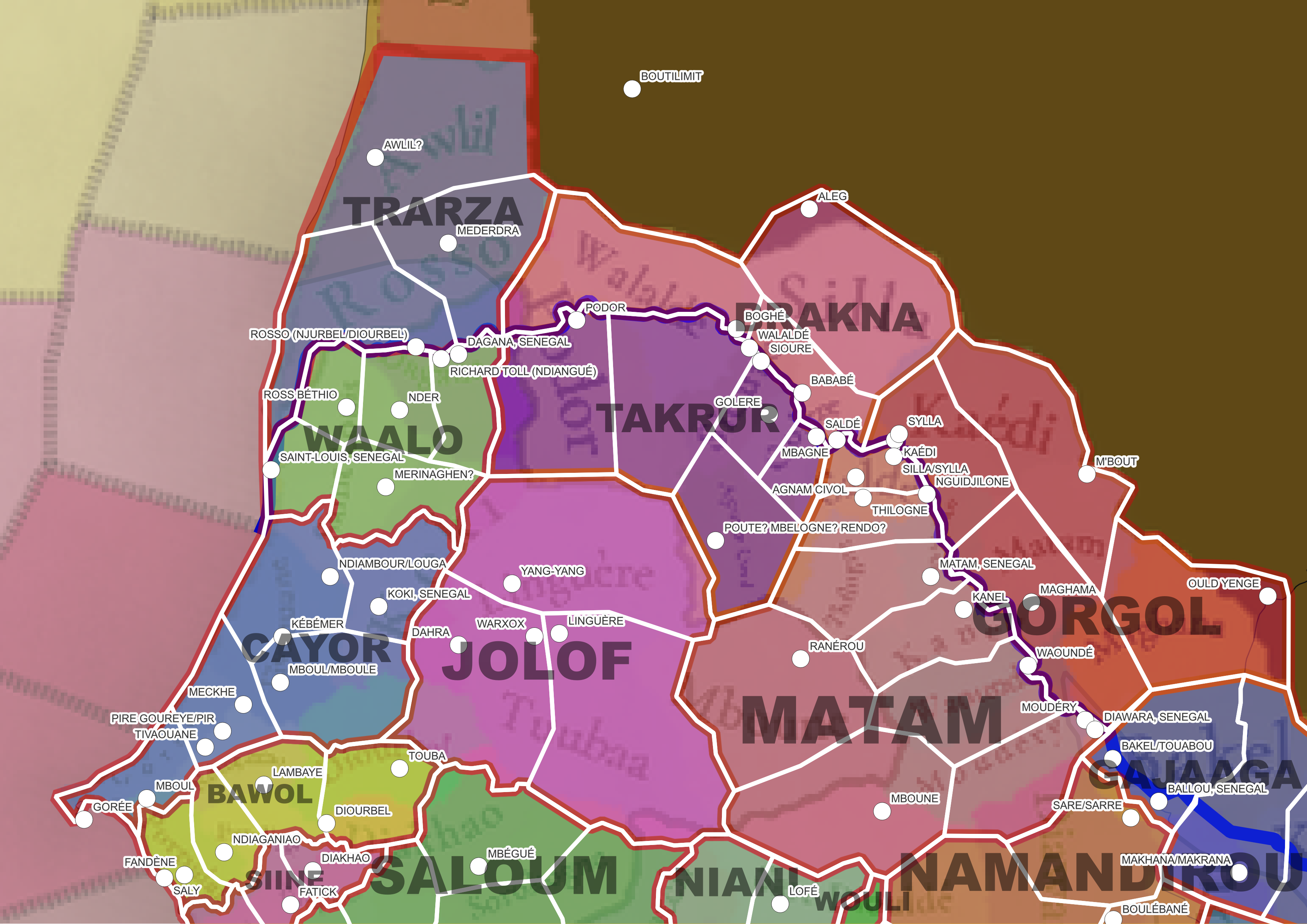
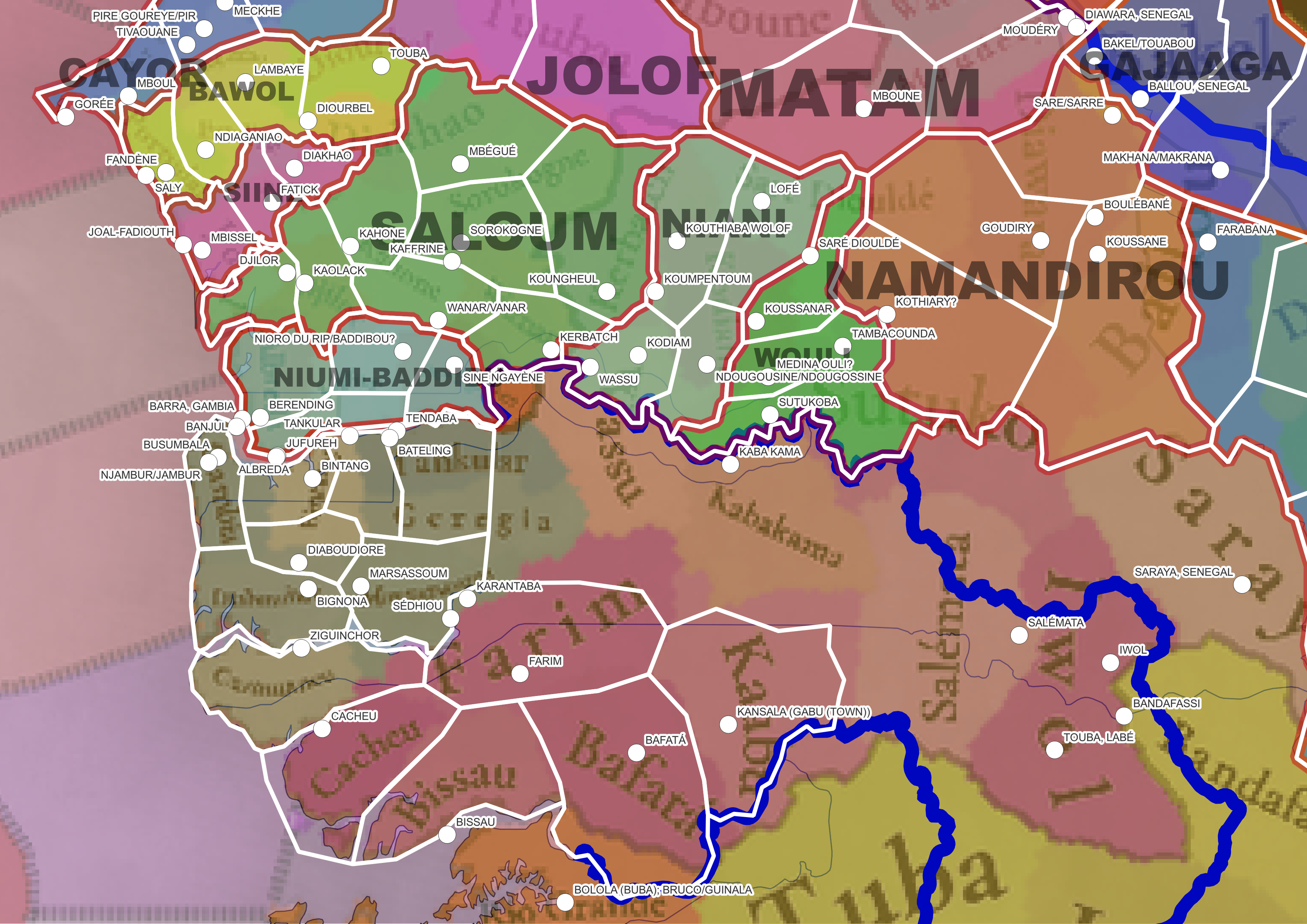
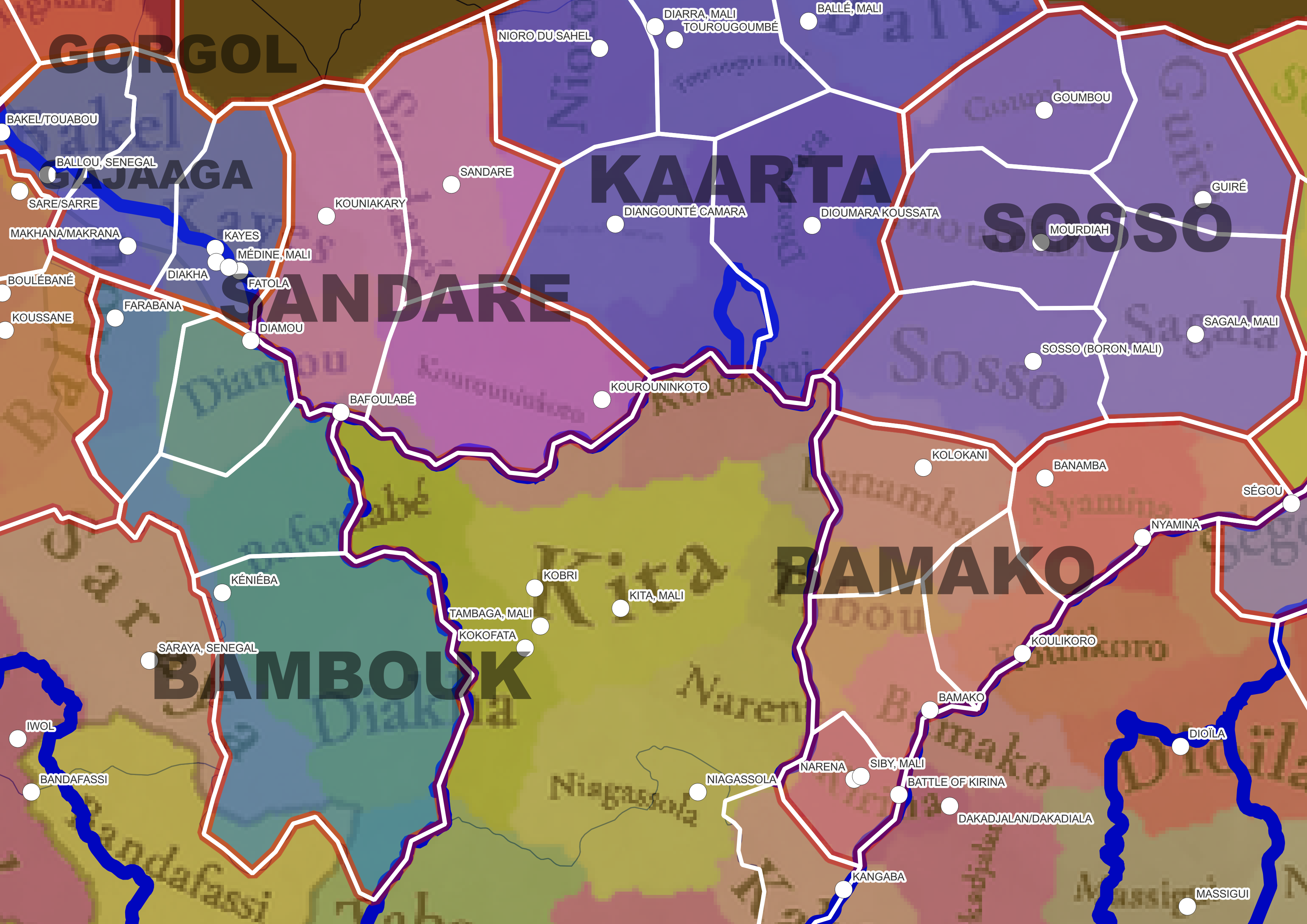
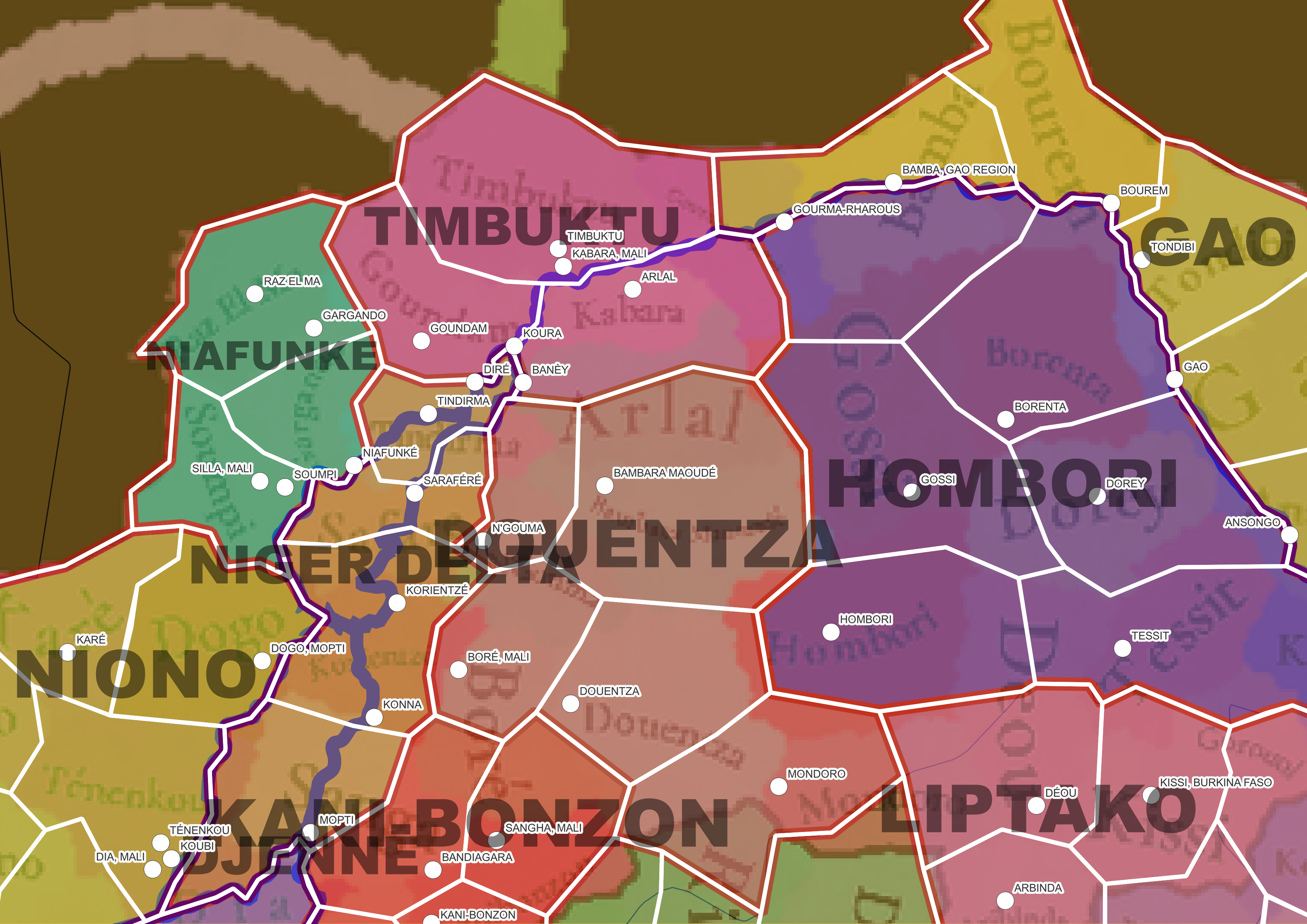
The locations of Western Africa. We’ve tried our best to find suitable locations, correct naming, etc., although I’m sure there might be plenty of feedback to apply.

Provinces:
Provinces.png


Areas:
Areas.png


Terrain:
Climate.png

Topography.png

Vegetation.png

This week we have proper Terrain mapmodes at the release of the Tinto Maps… Not much to say about them, though, as the climate and vegetation are pretty straightforward, being divided into Arid and Tropical; while the vegetation goes from desert and sparse beside the Sahara, to increasingly more forested terrain, until reaching the tropical jungles by the coast. The topography is not very fragmented, with the Guinean Highlands and the Adamawa Plateau being the most important landmarks.

Natural Harbors:
Harbors.png

A new map mode this week, coming from the latest Tinto Talks! There are some decent natural harbors in the region, with Banana Islands (where Freetown would be founded), Elmina, and Calabar being the best ones.

Cultures:
Cultures.png

A beautiful map this week… I may repeat that we tried our best to approach the region, taking into account that this was the first African region we completed, around 3 years ago. When we review it, we may add some more diversity, as we have now some more tools than the ones we had back in time, but we think that it’s way best to read your feedback first, to make sure we are on the same page.

Religions:
Religion.png

Take this map as very WIP. The Sunni-Animism division is kind of accurate, with the expected division for 1337 (Islam would later on advance more to the South, but we think this is the best for this date). What we have yet to do is to divide the ‘Animism’ population into some of the regional variants; we already have plenty of data, but we also want to read your feedback on this first.

Raw Materials:
Raw Materials.png

The goods of the region are quite diverse and very dependent on the geography. In the Saharan lands, there are plenty of locations with resources such as Salt, Copper, or Alum (regarding this resource, the lands to the north of Lake Chad make for the densest Alum hub in the world for 1337, something the historical sources talk about). Livestock is king in the Sahelian lands, while there are plenty of agricultural goods in the Niger river basin. The region is also full of luxury goods, of which Gold is the most relevant, as being the biggest supply of this metal to the Mediterranean and Europe in the Late Middle Ages, while also having others such as Ivory, Gems, or Spices (which in this region are portraying some goods such as kola nuts, or malagueta pepper). Finally, the coasts of the Gulf of Guinea have plenty of Fish. Maybe the only type of good that is not very abundant in the region is metals, as having some Iron, Tin, etc., but not much in comparison with other regions.

Markets:
Markets.png

Markets of the region, have an interesting distribution. The most important ones in 1337 are Niani, Kano, and Njimi, which are also connected to the Northern African markets, making it possible to get plenty of wealth by exporting well-demanded goods throughout the Sahara (for instance, exporting Gold or Alum for good money is a very viable strategy ATM). Later on, after the Age of Discovery, the coastal markets may get connected to other markets, making them more relevant, and maybe switching the power balance of the region from the North to the South, as historically happened (but take it as a ‘maybe’, not for granted, OFC!).

Population:
Population .png

Population 2.png

Population 3.png

Population 4.png

Population 5.png
Population of the region. We’ve improved a bit our tracking of the population data, to avoid further problems like the one we had with Germany. I can tell you that the total population of Western Africa is around 5.6M people, which is divided into 2.2M for the Sahel, and 3.3M for the coast of Guinea. You may very well notice that the hegemonic power here may be Mali, with around 700k people, but also that there are many more people not living under the rule of a polity, than living under it, which will make for interesting gameplay on how to deal with it (more about this in a later Tinto Talks, soon…).

And, speaking of that, I have the sad news that next Friday there is a bank holiday here in Spain, so there won’t be a Tinto Maps. The next one will be on Friday 23rd, and we will be taking a look at Eastern Africa! Until then, you may still stay tuned, as we will be replying to feedback, as usual, and we may have some informal maps incoming. Cheers!
 
  • 142Like
  • 69Love
  • 6
  • 4
  • 4
Reactions:
My journey with GIS continues! I got a bit burnt out of the project part way through since it's such a large area, but I wanted to share what I had found at least.

Some overall trends I noticed:
  • Quite a few places here that are outside of their borders alas! I've tried to note all the ones I've found here
  • Locations don't seem to line up with rivers at all, which seemed odd to me

NorthSenegambia.png


Out of position:
  • Rosso/Njurbel/Diourbel; Silla; Angam Civol; Thilogne; Matam; Maghama; Ballou; Mboune; Touba/Tuubaa; Tivaouane; Ndiaganiao; Fandène; Diourbel; Saldé; Diawara
I reorganized the provinces based on this map of the Wolof Empire. Going province by province:
  • Trarza (3 locations)
    • Added Mederdra, a capital of the Emirate of Trarza
    • Rosso seems to have been known as Diourbel/Ndiourbel/Njurbel and was once a capital of Waalo
  • Waalo (5 locations)
    • Added Ross Bethio; historically just Ross
    • Added Nder/N'Der - a capital of Waalo
    • Nidangué/Richard Toll is another capital of Waalo, but is too close to Dagana
    • Also added Merinaghen - not super historical, but there to fill space
  • Cayor (5 locations - Goree, Tivaouane, Mboul, Louga, Koki)
    • Added Louga, located in the Ndiambour - mostly there to fill space
  • Bawol (4 locations)
    • Change Portudal to Saly; Fandène also is an option but I think it's a new settlement
    • Add Lambaye, the capital of Bawol
  • Jolof (3 locations)
    • Added Yang-Yang, a capital of the Djolof Empire
    • Added Warxox/Ouarkokh/etc; another capital of the Djolof Empire
  • Brakna (3 locations)
    • Silla -> Aleg; Silla/Sylla is not located in this location (it's in Kaedi); can increase the location to become Aleg, which seems semi-historical?
    • Added Boghé to take up northern side of the river
    • Added Bababé for the same reason
  • Takrur (5 locations - Podor, Walaldé, Golere, Saldé, and Poute(?))
    • Sioure, Golere and Saldé are hard to all fit in here; sacrificed Sioure for the other two
    • Added Poute (or Mbelogne or Rendo) basically just to take up space so Golere and Saldé weren't super spindly - not terribly happy with this
  • Gorgol (4 locations)
    • Added Old Yenge and M'Bout to take up non-riverine portions
    • Split the rest into Kaédi and Maghama
  • Matam (8 locations - Agnam Civol, Thilogne, Matam, Kanel, Waoundé, Moudéry, Mboune, Ranérou)
    • Added Ranérou to take up space - the Ferlo is not a particularly densely populated area
    • Sacrifice Silla/Sylla for Agnam Civol

SouthSenegambia.png

Out of Position:
  • Diakhao; Juffure/Jufureh; Wanar/Vanar; Kerbatch; Kodiam; Tankular; Touba/Tuba;
Province by Province:
  • Siine/Sine (3 locations)
    • Joal(-Fadioth) - perhaps change to Mbissel, capital of Sine in the 14th century under Maysa Waali Maane
    • Added Fatick, a town with many World Heritage sites
  • Saloum (8 locations - Djilor, Kaolack, Kahone, Wanar, Kerbatch, Sorokogne, Mbegue, Kongheul)
    • Added Kaolack, satellite town to and successor of Kahone
    • Added Mbégué - to fill space
    • Added Koungheul - dates back to the 11th century
  • Niumi-Baddibu (4 locations; a conglomeration of the kingdoms of Niumi and Baddibu)
    • Added Barra/Berending; I've seen both listed as the capital of the Kingdom of Niumi
    • Albreda and Jufureh are very close together - I went with Albreda due to it being older
    • Added Nioro du Rip/Baddibu. I've not found much information about Baddibu's capital, other than it was also called Baddibu - it seems to line up with the location of Nioro du Rip, so I've just marked them here with the same dot
  • Niani (4 locations - Wassu, Ndougossine, Koumpentoun, Lofé)
    • Added Kompentoum, an early capital of the Kingdom of Niani
    • Added Lofé to take up space
    • Added Ndougousine, a later capital of Niani
  • Wouli/Wuli (3 locations - Koussanar, Medina Ouli, Sutuko/Sutukoba)
    • Added Medina Ouli - the capital of Wouli/Wuli/Ouli
    • Saré Diouldé -> Koussanar, a more sizeable yet still pre-colonial settlement
  • Namandirou/Njarmeew/Boundou (4 locations)
    • Sare/Sarre - the capital of Namandirous
    • Added Boulébané - capital of the theocratic kingdom of Bundu/Boundou
    • Added Goudiry and Kothiary - space fillers
  • UNORGANIZED (southern Senegal/Gambia)
    • Gambia -> Busumbala, capital of the Kingdom of Kombo
    • Add Tendaba, the other Kiang port alongside Tankular
    • Add Bignona - the main town of the Foni/Fogny


WesternMali.png

Out of Location: Maybe Diarra?; Banamba; Narena; Dakadjalan/Dakadiala; Kolokani

Province by Province:
  • Gajaaga (3 locations - Bakel/Touabou; Makhana/Makrana; Kayes)
    • Added Makhana/Makrana - a capital of the Kingdom of Galam/Kaméra
  • Sandare (for lack of better name - 3 locations)
    • Added Kouniakary to take up space
  • Kaarta (6 locations - Ballé, Tourougoumbé, Diarra, Nioro (du Sahel), Diangounté Camara, Dioumara Koussata)
    • Might need to adjust border of Diarra/Tourougoumbé to make sure that Diarra is within its borders
  • Bamako (5 locations? not certain)
    • Banamba -> Kolokani; Neither Banamba nor Kolokani are in their locations
  • Bambouk (4 locations)
    • Added Farabana, major Bambouk town
    • Added Keniéba - unsure of how old it is, but I couldn't find info on Diakha.

Timbuktu.png

Out of location: Arlal, Kabara, Sanga/Sangha, Dia? (can't make out the border between it and Tenenkou); Gorouol

Province by province:
  • Niger Delta
    • Is Safare the same as Saraféré?
    • Add Tindirma, dating to 1496
    • Add Mopti to fill in for Sangha; dates to the 19th c. original name was Sagan/Saghan
  • Kani-Bonzon
    • Add Bandiagara, dates to 1770; a capital of the Toucouleur Empire
  • Liptako
    • Readjust to better match the borders of IRL Liptako:
      • Deóu, Kissi, Arbinda, Dori, Téra, Bura/Dargol, Kokorou

GoldCoast.png

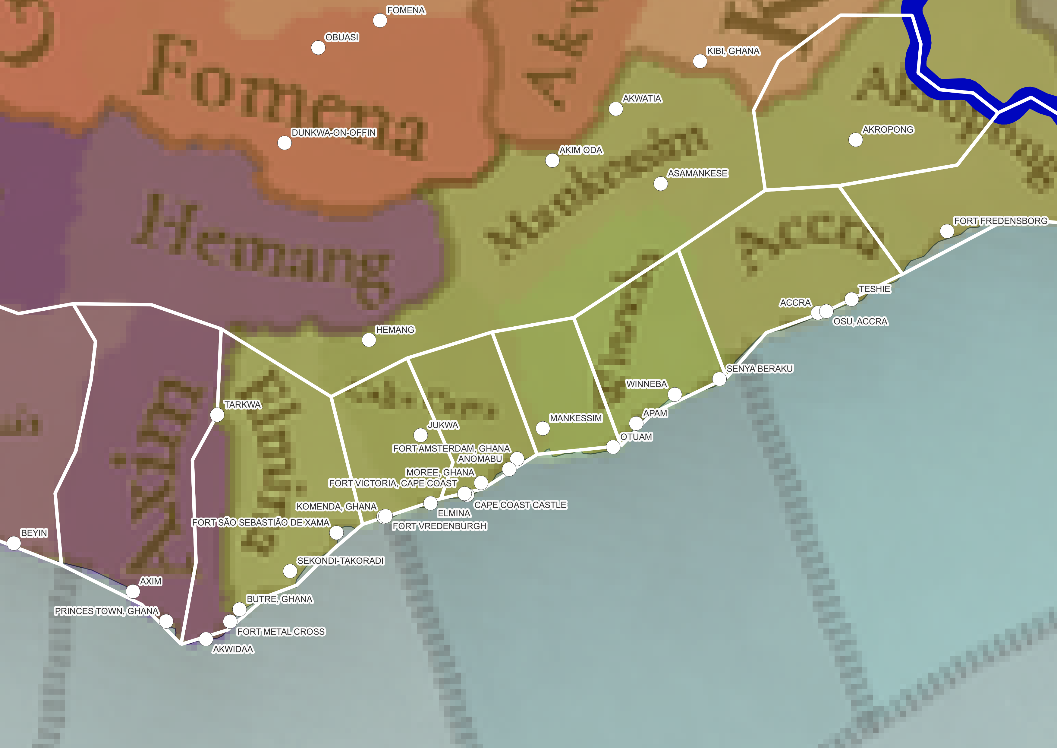
Out of Location: Elmina, Hemang

Could add a few more locations here, from west to east I have:
  • Axim
  • Sekondi, Xama
  • Elmina, Vredenburgh
  • Cape Coast, Moree, Fort Amsterdam
  • Mankessim
  • Winneba
  • Accra
  • Fort Fredensborg, Fort Kongenstein

Other non-mapped places outside of their locations:
Cess (river?), Toumodi, Morondo, Touba (Ivory Coast), Konkouré, Bandafassi, Mandiana, Niantjila, Bankuy, Banfora, Farakala, Mankessim, Akwatia, Yeji, Begho, Diébougou, Paga, Pusiga, Bimbilla, Agbonle, Ijebu Ode, Epe, Oke Ila, Oshogbo, Ikoyi Ile, Tede, Offa, Akure, Ewu, Uromi, Ukunzu, Enugu, Ugbo, Igbo-Ukwu, Amaigbo, Azia, Warri, Forcados, Ikom, Wukari, Mbakaou, Yoko & Mbam (I think these 2 are switched); Kumba, Oyem, Zuba, Minna, Banikoara, Mansila, Tondikandia, Hamdallaye, Kaouara, Sokoto, Goronyo, Dogondoutchi, Birni Ader, Gusau, Pankshin, Jos, Bauchi, Gwaram, Birnin Kudu, Auyo, Goudoumaria, Gouré, N'Guigmi, N'gousa, Djédaa, Kéroua, Bongor

Happy to provide more images of my map if that's helpful - but also didn't want to spam too much!
 
  • 6
  • 5Like
  • 2Love
Reactions:
My journey with GIS continues! I got a bit burnt out of the project part way through since it's such a large area, but I wanted to share what I had found at least.

Some overall trends I noticed:
  • Quite a few places here that are outside of their borders alas! I've tried to note all the ones I've found here
  • Locations don't seem to line up with rivers at all, which seemed odd to me

View attachment 1178309

Out of position:
  • Rosso/Njurbel/Diourbel; Silla; Angam Civol; Thilogne; Matam; Maghama; Ballou; Mboune; Touba/Tuubaa; Tivaouane; Ndiaganiao; Fandène; Diourbel; Saldé; Diawara
I reorganized the provinces based on this map of the Wolof Empire. Going province by province:
  • Trarza (3 locations)
    • Added Mederdra, a capital of the Emirate of Trarza
    • Rosso seems to have been known as Diourbel/Ndiourbel/Njurbel and was once a capital of Waalo
  • Waalo (5 locations)
    • Added Ross Bethio; historically just Ross
    • Added Nder/N'Der - a capital of Waalo
    • Nidangué/Richard Toll is another capital of Waalo, but is too close to Dagana
    • Also added Merinaghen - not super historical, but there to fill space
  • Cayor (5 locations - Goree, Tivaouane, Mboul, Louga, Koki)
    • Added Louga, located in the Ndiambour - mostly there to fill space
  • Bawol (4 locations)
    • Change Portudal to Saly; Fandène also is an option but I think it's a new settlement
    • Add Lambaye, the capital of Bawol
  • Jolof (3 locations)
    • Added Yang-Yang, a capital of the Djolof Empire
    • Added Warxox/Ouarkokh/etc; another capital of the Djolof Empire
  • Brakna (3 locations)
    • Silla -> Aleg; Silla/Sylla is not located in this location (it's in Kaedi); can increase the location to become Aleg, which seems semi-historical?
    • Added Boghé to take up northern side of the river
    • Added Bababé for the same reason
  • Takrur (5 locations - Podor, Walaldé, Golere, Saldé, and Poute(?))
    • Sioure, Golere and Saldé are hard to all fit in here; sacrificed Sioure for the other two
    • Added Poute (or Mbelogne or Rendo) basically just to take up space so Golere and Saldé weren't super spindly - not terribly happy with this
  • Gorgol (4 locations)
    • Added Old Yenge and M'Bout to take up non-riverine portions
    • Split the rest into Kaédi and Maghama
  • Matam (8 locations - Agnam Civol, Thilogne, Matam, Kanel, Waoundé, Moudéry, Mboune, Ranérou)
    • Added Ranérou to take up space - the Ferlo is not a particularly densely populated area
    • Sacrifice Silla/Sylla for Agnam Civol

View attachment 1178310
Out of Position:
  • Diakhao; Juffure/Jufureh; Wanar/Vanar; Kerbatch; Kodiam; Tankular; Touba/Tuba;
Province by Province:
  • Siine/Sine (3 locations)
    • Joal(-Fadioth) - perhaps change to Mbissel, capital of Sine in the 14th century under Maysa Waali Maane
    • Added Fatick, a town with many World Heritage sites
  • Saloum (8 locations - Djilor, Kaolack, Kahone, Wanar, Kerbatch, Sorokogne, Mbegue, Kongheul)
    • Added Kaolack, satellite town to and successor of Kahone
    • Added Mbégué - to fill space
    • Added Koungheul - dates back to the 11th century
  • Niumi-Baddibu (4 locations; a conglomeration of the kingdoms of Niumi and Baddibu)
    • Added Barra/Berending; I've seen both listed as the capital of the Kingdom of Niumi
    • Albreda and Jufureh are very close together - I went with Albreda due to it being older
    • Added Nioro du Rip/Baddibu. I've not found much information about Baddibu's capital, other than it was also called Baddibu - it seems to line up with the location of Nioro du Rip, so I've just marked them here with the same dot
  • Niani (4 locations - Wassu, Ndougossine, Koumpentoun, Lofé)
    • Added Kompentoum, an early capital of the Kingdom of Niani
    • Added Lofé to take up space
    • Added Ndougousine, a later capital of Niani
  • Wouli/Wuli (3 locations - Koussanar, Medina Ouli, Sutuko/Sutukoba)
    • Added Medina Ouli - the capital of Wouli/Wuli/Ouli
    • Saré Diouldé -> Koussanar, a more sizeable yet still pre-colonial settlement
  • Namandirou/Njarmeew/Boundou (4 locations)
    • Sare/Sarre - the capital of Namandirous
    • Added Boulébané - capital of the theocratic kingdom of Bundu/Boundou
    • Added Goudiry and Kothiary - space fillers
  • UNORGANIZED (southern Senegal/Gambia)
    • Gambia -> Busumbala, capital of the Kingdom of Kombo
    • Add Tendaba, the other Kiang port alongside Tankular
    • Add Bignona - the main town of the Foni/Fogny


View attachment 1178316
Out of Location: Maybe Diarra?; Banamba; Narena; Dakadjalan/Dakadiala; Kolokani

Province by Province:
  • Gajaaga (3 locations - Bakel/Touabou; Makhana/Makrana; Kayes)
    • Added Makhana/Makrana - a capital of the Kingdom of Galam/Kaméra
  • Sandare (for lack of better name - 3 locations)
    • Added Kouniakary to take up space
  • Kaarta (6 locations - Ballé, Tourougoumbé, Diarra, Nioro (du Sahel), Diangounté Camara, Dioumara Koussata)
    • Might need to adjust border of Diarra/Tourougoumbé to make sure that Diarra is within its borders
  • Bamako (5 locations? not certain)
    • Banamba -> Kolokani; Neither Banamba nor Kolokani are in their locations
  • Bambouk (4 locations)
    • Added Farabana, major Bambouk town
    • Added Keniéba - unsure of how old it is, but I couldn't find info on Diakha.

View attachment 1178322
Out of location: Arlal, Kabara, Sanga/Sangha, Dia? (can't make out the border between it and Tenenkou); Gorouol

Province by province:
  • Niger Delta
    • Is Safare the same as Saraféré?
    • Add Tindirma, dating to 1496
    • Add Mopti to fill in for Sangha; dates to the 19th c. original name was Sagan/Saghan
  • Kani-Bonzon
    • Add Bandiagara, dates to 1770; a capital of the Toucouleur Empire
  • Liptako
    • Readjust to better match the borders of IRL Liptako:
      • Deóu, Kissi, Arbinda, Dori, Téra, Bura/Dargol, Kokorou

View attachment 1178325
Out of Location: Elmina, Hemang

Could add a few more locations here, from west to east I have:
  • Axim
  • Sekondi, Xama
  • Elmina, Vredenburgh
  • Cape Coast, Moree, Fort Amsterdam
  • Mankessim
  • Winneba
  • Accra
  • Fort Fredensborg, Fort Kongenstein

Other non-mapped places outside of their locations:
Cess (river?), Toumodi, Morondo, Touba (Ivory Coast), Konkouré, Bandafassi, Mandiana, Niantjila, Bankuy, Banfora, Farakala, Mankessim, Akwatia, Yeji, Begho, Diébougou, Paga, Pusiga, Bimbilla, Agbonle, Ijebu Ode, Epe, Oke Ila, Oshogbo, Ikoyi Ile, Tede, Offa, Akure, Ewu, Uromi, Ukunzu, Enugu, Ugbo, Igbo-Ukwu, Amaigbo, Azia, Warri, Forcados, Ikom, Wukari, Mbakaou, Yoko & Mbam (I think these 2 are switched); Kumba, Oyem, Zuba, Minna, Banikoara, Mansila, Tondikandia, Hamdallaye, Kaouara, Sokoto, Goronyo, Dogondoutchi, Birni Ader, Gusau, Pankshin, Jos, Bauchi, Gwaram, Birnin Kudu, Auyo, Goudoumaria, Gouré, N'Guigmi, N'gousa, Djédaa, Kéroua, Bongor

Happy to provide more images of my map if that's helpful - but also didn't want to spam too much!
Would definitely not mind seeing southern Nigeria, I did notice that in Igboland they chose many locations that are right next to each in reality but spread them out and that can't look good. Also wow Mankessim is off by a lot.
 
Last edited:
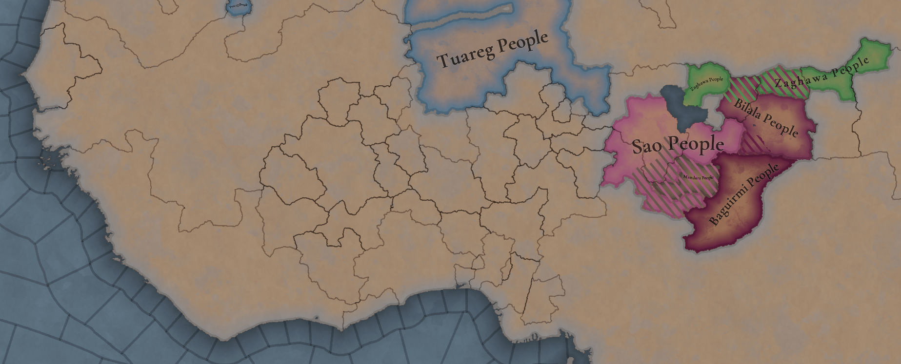
Hi there! An update after the last Tinto Talks, with the current 'Society of Pops' existing in Western Africa:

Pop-based.png


A couple of notes about this:
1. This is very far from final )I'd say that the countries are only perfectly fitting around the Lake Chad area).
2. There will be tons of tag changes when we review this Tinto Maps. As you might have noticed, there are plenty of tags that would fit into the different categories, which are not fitting now. We shared this 'placeholdery' stuff on purpose, because we thought that it would be much more efficient to make an in-depth review of the region after receiving your feedback in this DD. We will then share the rework with you, and receive additional feedback about it, as being our usual review loop.
 
  • 38Like
  • 14Love
  • 7
Reactions:
Hi there! An update after the last Tinto Talks, with the current 'Society of Pops' existing in Western Africa:

View attachment 1178462

A couple of notes about this:
1. This is very far from final )I'd say that the countries are only perfectly fitting around the Lake Chad area).
2. There will be tons of tag changes when we review this Tinto Maps. As you might have noticed, there are plenty of tags that would fit into the different categories, which are not fitting now. We shared this 'placeholdery' stuff on purpose, because we thought that it would be much more efficient to make an in-depth review of the region after receiving your feedback in this DD. We will then share the rework with you, and receive additional feedback about it, as being our usual review loop.
Thank you for the update! I am surprised the Yoruba city states do not even get this much organization- not that I am suggesting they should be made into Stateless Societies! We learnt in the Tinto Talks that Societies of Pops do not interact with RGOs (and presumably other buildings too), which makes that representation absolutely unsuitable for urban city states. They should be individual conventional tags on the map, maybe in an International Organization. If the Holy Roman Empire and Italy can have tiny city border gore than SO CAN THE LOWER NIGER!
 
  • 13Like
  • 6
Reactions:
Great feedback, thanks a lot!
I will add regarding the Yoruba information, there is also some tradition which states that Ifẹ̀ had dominance over Ọ̀yọ́ and Benín at this time, which seems to have exceeded the status of being the regional hegemon and even have been to the extent of a relatively loose subject relationship. In EU4 terms, I think it would have been a tributary.

I also wonder what sources may be used for the form of Yoruba religion at this time. The modern form of the Yoruba traditional religion is not particularly animistic, but even how it has changed since the split of Nigerian and diaspora (that is, enslaved) practitioners is hard to get at, so going back further with even less reference seems impossible. I would be happy to learn of whatever sources are being used for this.
 
Last edited:
  • 4Like
Reactions:
Hi there! An update after the last Tinto Talks, with the current 'Society of Pops' existing in Western Africa:

View attachment 1178462

A couple of notes about this:
1. This is very far from final )I'd say that the countries are only perfectly fitting around the Lake Chad area).
2. There will be tons of tag changes when we review this Tinto Maps. As you might have noticed, there are plenty of tags that would fit into the different categories, which are not fitting now. We shared this 'placeholdery' stuff on purpose, because we thought that it would be much more efficient to make an in-depth review of the region after receiving your feedback in this DD. We will then share the rework with you, and receive additional feedback about it, as being our usual review loop.
Oh god I love it!

Maybe the Bozo people would make sense as an SoP? From what I understand they were mostly unsettled and lived mostly along the Niger river, but the Mali Empire tried to control them because they could make a good river navy, and they were instrumental to the spread of the Songhai Empire which only took control of some major cities thanks to Bozo ships and crews.
The Fulani and Ashanti also come to my mind, especially considering how they appeared as tags out of nowhere in AoE4...
 
  • 4Like
  • 2
Reactions:
Hi there! An update after the last Tinto Talks, with the current 'Society of Pops' existing in Western Africa:

View attachment 1178462

A couple of notes about this:
1. This is very far from final )I'd say that the countries are only perfectly fitting around the Lake Chad area).
2. There will be tons of tag changes when we review this Tinto Maps. As you might have noticed, there are plenty of tags that would fit into the different categories, which are not fitting now. We shared this 'placeholdery' stuff on purpose, because we thought that it would be much more efficient to make an in-depth review of the region after receiving your feedback in this DD. We will then share the rework with you, and receive additional feedback about it, as being our usual review loop.
Considering that the lamtuna created the almoravid sultanate I would say that it makes sense to have them as a SOP, same with some of the other minor amazigh groups in the area.
About the tuareg I still think that the kingdom of takedda should start as an actual landed tag.
 
  • 3Like
  • 2
Reactions:
Hi there! An update after the last Tinto Talks, with the current 'Society of Pops' existing in Western Africa:

View attachment 1178462

A couple of notes about this:
1. This is very far from final )I'd say that the countries are only perfectly fitting around the Lake Chad area).
2. There will be tons of tag changes when we review this Tinto Maps. As you might have noticed, there are plenty of tags that would fit into the different categories, which are not fitting now. We shared this 'placeholdery' stuff on purpose, because we thought that it would be much more efficient to make an in-depth review of the region after receiving your feedback in this DD. We will then share the rework with you, and receive additional feedback about it, as being our usual review loop.
I'd venture that most of the uncolonized areas in West Africa could fit in the category of SoP, as they were settled, agricultural (or in some cases relatively populous fisher societies), and had chiefdoms. Including the Ijaw, Idoma, Igala, your "Bantoid" culture, "Benue", Ewe, Fon, Bassa, Bubi, Kru, uncolonized Akans, Kissi, Temne, Baga, Bullom, Gola, Dan, and definitely the Kpelle and Kono (although I'd consider them as Mane culture in 1337) so that they can invade Sierra Leone + Liberia.

I personally would represent most of Igboland as a SoP and Nri as a one or two location minor that exerts influence on the surrounding region through religious propagation. I'd also probably revert Borgu to an SoP rather than a unified country.

I'd like to see these societies have a bit more agency in interacting with the wider region, but I also want it to be highly unlikely for any of them to expand or conquer their neighbors (with the exception of the Kpelle/Kono, which could portrayed through events), at least without forming proper states.
 
Last edited:
  • 8Like
Reactions:
Gola - Society of Pops

A people group noted to have migrated from the the Ghana to Liberia between the 1200-1300s. There is a popular myth this was done under Kanda Dazujuaha forming the kingdom of Ngola (Of the Gola). In oral tradition they have documented conflict with the Kissi and other groups. Had a rigorous agricultural system that often provided a surplus above subsistence and their cultural traditions are heavily seeped in agriculture. They also organise more along clan dynamics than kin. There is also the Sande and Poro a really fascinating cultural institution that kept tradition and order.

In my honest opinion they should be treated as a Society of Pops at the game start. They were settled, had a societal structure with clans not familial kins, heavily agricultural and depending on your outlook they had diplomacy with many other tribes/groups.

Paul Richards, Forest and Indigenous Peoples - Academic Source talks around but confirms much of the Ethnographer
101LostTribes - Reliable Ethnographer
UTA - reliability is questionable imho
 
  • 9Like
  • 1
Reactions:
I'd venture that most of the uncolonized areas in West Africa could fit in the category of SoP, as they were settled, agricultural (or in some cases relatively populous fisher societies), and had chiefdoms. Including the Ijaw, Idoma, Igala, your "Bantoid" culture, "Benue", Ewe, Fon, Bassa, Bubi, Kru, uncolonized Akans, Kissi, Temne, Baga, Bullom, Gola, Dan, and definitely the Kpelle and Kono (although I'd consider them as Mane culture in 1337) so that they can invade Sierra Leone + Liberia.

I personally would represent most of Igboland as a SoP and Nri as a one or two location minor that exerts influence on the surrounding region through religious propagation.

I'd like to see these societies have a bit more agency in interacting with the wider region, but I also want it to be highly unlikely for any of them to expand or conquer their neighbors (with the exception of the Kpelle/Kono, which could portrayed through events), at least without forming proper states.
Although I would agree some are not as cut and dry.

Ewe/Fon were organised upon Kin relations and were likely subsistence farmers with hunting. It is not until we approach the 1500s, that they transitioned from Kin organisation to wider clan structures. Eventually leading to the foundation of Dahomey for example. My suggestion is that they become a SoP through an event in the late 1400s and depending on how much railroading Pdx wants, becomes settled during and forming Dahomey between 1550-1650.

Similar with the Kru we know a lot about them but near nothing before 1600s. It is likely they were subsistence hunters and fisherman.

Although I wouldnt be upset with all these as SoP, but the criteria they gave out suggests they most likely would not be at the start of the game. Maybe we can get a semi-random formation of SoPs throughout the 1400-1500s for these groups. It is important to note most of these groups had only just migrated in and some are even debated to be here this early.

The only group off the top of my head that fits is the Gola as I posted about (and the Kissi but they might have had a society collapse in the 1300s). Im going to spend a lot of time seeking out sources and ethnographers for this. If you have any sources for these other groups. Please share.
 
  • 3
  • 1Like
  • 1
Reactions:
Although I would agree some are not as cut and dry.

Ewe/Fon were organised upon Kin relations and were likely subsistence farmers with hunting. It is not until we approach the 1500s, that they transitioned from Kin organisation to wider clan structures. Eventually leading to the foundation of Dahomey for example. My suggestion is that they become a SoP through an event in the late 1400s and depending on how much railroading Pdx wants, becomes settled during and forming Dahomey between 1550-1650.

Similar with the Kru we know a lot about them but near nothing before 1600s. It is likely they were subsistence hunters and fisherman.

Although I wouldnt be upset with all these as SoP, but the criteria they gave out suggests they most likely would not be at the start of the game. Maybe we can get a semi-random formation of SoPs throughout the 1400-1500s for these groups. It is important to note most of these groups had only just migrated in and some are even debated to be here this early.

The only group off the top of my head that fits is the Gola as I posted about (and the Kissi but they might have had a society collapse in the 1300s). Im going to spend a lot of time seeking out sources and ethnographers for this. If you have any sources for these other groups. Please share.
I could agree with Kru not being SoPs, they are among the most isolated groups in West Africa for sure. Though I think there are some fishing groups in the world who should qualify as SoPs.

We should find sources on the spread of agriculture in the region, that will be a great basis and will help us argue any cases to be made.
 
Last edited:
  • 3Like
Reactions:
I could agree with Kru not being SoPs, they are among the most isolated groups in West Africa for sure. Though I think there are some fishing groups in the world who should qualify as SoPs.

We should find sources on the spread of agriculture in the region, that will be a great basis and will help us argue any cases to be made.
Im pretty busy, so my progress will be more slow. Im going to work on the north coast more.

101LostTribes is a great ethnographer, but try not to take it for fact as its a more modern analysis when discussing some aspects. I have some academic sources im gonna follow up next week. Feel free to DM if you want to cross reference each other.

I feel at the very least SoP if not at the start should become more common as the game progresses via events etc. Just because a SoP doesnt fit at game start doesnt mean we should ignore one forming later on.
 
  • 3Like
  • 1
Reactions:
Im pretty busy, so my progress will be more slow. Im going to work on the north coast more.

101LostTribes is a great ethnographer, but try not to take it for fact as its a more modern analysis when discussing some aspects. I have some academic sources im gonna follow up next week. Feel free to DM if you want to cross reference each other.

I feel at the very least SoP if not at the start should become more common as the game progresses via events etc. Just because a SoP doesnt fit at game start doesnt mean we should ignore one forming later on.
Does subsistence agriculture supplemented with hunting disqualify a society? I mean, afaik that is common to a lot of societies that are depicted as landed tags. What Pavia said was "agricultural development", and that natives are typically hunter-gatherers or shifting agriculturalists.

I'd like to see your sources on kin vs clan organization when you have time, could be very illuminating.
 
  • 1
Reactions:
Does subsistence agriculture supplemented with hunting disqualify a society? I mean, afaik that is common to a lot of societies that are depicted as landed tags. What Pavia said was "agricultural development", and that natives are typically hunter-gatherers or shifting agriculturalists.

I'd like to see your sources on kin vs clan organization when you have time, could be very illuminating.
Ill add it to my reminders and get back to you.

I understand your point on farming, it is a grey area. Since the Amazonian tribes had gardens and slash/burn agriculture more so than hunting. But were most likely atomised kinships. I personally think clan organisation and moving way from atomised kinships is more the qualifying category to me with intensive agriculture or herding being a supplementary qualifier that cements the position. If you disagree that is perfectly fine, it is open to debate.
 
  • 2Like
  • 2
  • 1
Reactions:
I'd venture that most of the uncolonized areas in West Africa could fit in the category of SoP, as they were settled, agricultural (or in some cases relatively populous fisher societies), and had chiefdoms. Including the Ijaw, Idoma, Igala, your "Bantoid" culture, "Benue", Ewe, Fon, Bassa, Bubi, Kru, uncolonized Akans, Kissi, Temne, Baga, Bullom, Gola, Dan, and definitely the Kpelle and Kono (although I'd consider them as Mane culture in 1337) so that they can invade Sierra Leone + Liberia.

I personally would represent most of Igboland as a SoP and Nri as a one or two location minor that exerts influence on the surrounding region through religious propagation. I'd also probably revert Borgu to an SoP rather than a unified country.

I'd like to see these societies have a bit more agency in interacting with the wider region, but I also want it to be highly unlikely for any of them to expand or conquer their neighbors (with the exception of the Kpelle/Kono, which could portrayed through events), at least without forming proper states.
I think "most" is not likely correct. My understanding is that a society of pops requires a relatively strong tribal identity, or preferably some form of tribe-level organization. But to my knowledge the concept of tribalism is not even indigenous to this region but rather, it was mostly villages and city states or occasionally extended family clans which, if they became larger, were more likely to form a small empire or kingdom where they hold exclusive power (landed tags) rather than something like a society of pops. When it comes to what counts as SoP, although there's some ambiguity, it seems like it's intended for something a bit more unified. That being the case there should probably be some evidence of such, for any proposed society.
 
Last edited:
Given the criteria you have given in the newer TTs/TMs, it appears that most of Western Africa falls into the cathegory that could make their cultures into Stateless Societies (Societies of Pops but I don't like that name I think Stateless Society would be more dignified).

I do wonder about the implications of areas where the majority culture of several states (such as Yoruba or Akan) is also a culture found in uncolonized/stateless area, like for example how would they go about settling those areas/colonizing them
 
  • 3Like
Reactions:
I think "most" is not likely correct. My understanding is that a society of pops requires a relatively strong tribal identity, or preferably some form of tribe-level organization. But to my knowledge the concept of tribalism is not even indigenous to this region but rather, it was mostly villages and city states or occasionally extended family clans which, if they became larger, were more likely to form a small empire or kingdom where they hold exclusive power (landed tags) rather than something like a society of pops. When it comes to what counts as SoP, although there's some ambiguity, it seems like it's intended for something a bit more unified. That being the case there should probably be some evidence of such, for any proposed society.
Was it mentioned somewhere that society of pops are usually tribes? And how would you define tribe or tribalism in the first place?
 
Was it mentioned somewhere that society of pops are usually tribes? And how would you define tribe or tribalism in the first place?
Maybe not necessarily tribal as such, but criteria include some manner of "chiefdomly authority" and taxation without having monopoly on violence or public works, and even moreso that they seem to largely be cultural groups, and work together to have armies and stuff. All that together seems like they're basically tribes. Maybe I'm making assumptions and reading too much into it, I dunno, but I think they only didn't call it that because the term comes with baggage and interpretations that might box them in. And because the thing about agriculture and permanent settlements means that they're not very nomadic – despite that they can move their pops as a mechanic.