• We have updated our Community Code of Conduct. Please read through the new rules for the forum that are an integral part of Paradox Interactive’s User Agreement.

Tinto Maps #15 - 23rd of August 2024 - Horn of Africa

Hello, and welcome one more week to Tinto Maps! After a short break, we’re back to the duty of sharing more maps! Today the region we will look at is the Horn of Africa! So let’s take a look at it, without further ado:

Countries:
Countries.PNG

Here we have the countries around Nubia, Ethiopia, and Somalia. The first ones are organized around the ancient kingdoms of Makuria and Alodia, which control the Upper Nile region. In the second area, the Empire of Ethiopia stands as the main power, with some smaller countries around it. Finally, the two Islamic sultanates of Ifat and Ajuraan stand as the main powers in the Horn and Somalia. Finally, around the African Great Lakes, there is a country that can be considered a ‘settled’ one, Kitara.

Dynasties:
Dynasties.PNG

The dynasties of the Horn. There are some historical ones, while others are randomly generated. The most famous one is probably the Ethiopian House of Solomon, from where all their Negus come. The Walshma ruler over both Ifat and Ajuraan and we have some others, such as the Medri of Medri Bahri, the Umar of Mogadishu, the Banu Kanz of Makuria, or the Baranzi of Kitara.

Societies of Pops:
Pop-Based.PNG

A new map has popped up! Here you can see the countries that we consider as ‘Societies of Pops’, as they were presented in the last Tinto Talks. We have the famous Oromo people in the lands between Ethiopia, Ifat and Ajuraan; the Kunama, Gumuz, and Berta in the lands between Ethiopia; and Alodia, and the Zaghwa to the north of Wadai; there are a few more to the west, but I’ll share that picture in the Western Africa thread, as it’s more appropriate there. There are more Stateless Societies of this kind that we would like to add in the future, if it is possible due to our schedule.

Locations:
Locations.PNG

Locations 2.png

Locations 3.png

Locations 4.png

Locations 5.png
Locations! You might notice that the density is quite unequal. Unfortunately, the archaeological findings for the period are scarce, specially out of the most known areas and a lack of urbanization in most of the territory has made the finding of proper non-anachronistic settlements quite a challenge. Keep this in mind when making suggestions. ;) It has been that dramatic in some areas that we had to use names of tribes and rivers, a bit contradicting our own rules, but the areas had to be represented as they were active parts in the development of the region.
One thing: a big chunk of the Arabian peninsula can be seen in today’s Tinto Maps; but, please, reserve the feedback for its future DD, when we’ll show all of the peninsula. Apart from that, you can see more detailed maps if you click on the spoiler button, as usual.


Provinces:
Provinces.png


Areas:
Areas.png


Terrain:
Climate.png

Vegetation.png

Topography.png

The terrain types of the region are quite interesting and diverse. It is marked by the Rift Valley, which creates different biomes, such as the Ethiopian Highlands and Plateau, or the African Great Lakes. That also marks a divide between Arid, Tropical, and Oceanic climates. The vegetation of the region also ranges from desertic and sparse, to jungle forests. And one more note: you may also note that 'Marshes' have been renamed into 'Wetlands', as we could put some work into that suggestion the last week.

Natural Harbors:
Natural Harbors.png


Cultures:
Cultures.png

Another interesting map this week… You might notice that the lands of Ethiopia have a very mixed cultural situation. While more to the west and south, we are representing ‘tribal lands’ in a more homogeneous way, with kind of fixed boundaries to represent the different groupings. This doesn’t mean that there wouldn’t be a mixing of cultures, but this was one of the first areas to receive a minority's review and the scope was limited mostly to Ethiopia.

Religion:
Religion.png

Another interesting map! Miaphysite and Sunni are the more widespread religions in the region (while not all areas have their mixed populations, such as Nubia as you might notice, they eventually will as we cover more of the map in our sprints). Animism is completely placeholder, as usual, and you might see some pockets here and there (If you have specific suggestions, please do them). You may also notice a purple minority inside Ethiopia… That is representing the Beta Israel Judaism in the provinces of Semien, of course!

Raw Materials:
Raw Materials.png

The raw materials of this week! A big chunk of the region has livestock as its main raw material, while also having some agricultural goods as Wheat or Sturdy Grains here and there. The most unique good in the region is Coffee, which is cultivated in the Ethiopian highlands. And there are also some precious resources spread here and there, such as Gold, Ivory, Gems, and Incense.

Markets:
Markets.png

The main market centers of the region are Axum and Mogadishu, with ‘Adan/Aden being the main one controlling the access to the Red Sea. There are some weird calculations ongoing on the Somalian inner lands, that are already reported, and we’ll take a look at why is that happening.

Population:
Population.png

Population 2.png

Population 3.png

Population 4.png

Population 5.png
The population of the region! There are approximately 12.3M people in the Eastern African subcontinent; although take into account that it also comprises the regions of the Southern Great Lakes and the Swahili Coast, which we haven’t shown today, so we probably have to discount around 4M people from it (Swahili Coast accounts for 1.7M, and the Great Lakes for 4M, although that region is divided between today’s and next week’s Tinto Maps), for a total of around 8M.

That’s all for today! Speaking of next week’s Tinto Maps, it will be meaty, as it will cover Central, Eastern, and Southern Africa! See you!
 
  • 126Like
  • 39Love
  • 5
  • 4
  • 1
Reactions:
There are at least 4 countries missing in the Horn of Africa.
Hadiya, which was ruled by Garad Amano during the Ethiopian king Amda Seyon (1314 – 1344), which in turn subdued to Ethiopia around 1332, so they would be a vassal state.
The second tag is the Warsangali Sultanate, as well as the Tanade Sultanate in the Bari region, east of Warsangali.
The Tanade kingdom emerged around 1237 by Ugas Mahamed Aw Maki (Ugas is the term for king). So by the Project Caesar start date of 1337, the ruler there would possibly be Ugas Hobanle, the 4th ruler in the line of the dynasty, or his predecessor Ugas Dirir, as it is unclear how long those figures ruled, but would personally assume an average of 25 years.
Sources for Tanade (which is the Somali and most likely therefore English name):

https://so.wikipedia.org/wiki/Laylkase

The 4th country would be Harla, a smaller kingdom in between Ethiopia and Ifat. But there were also other smaller entities in the Awash basin.


Would love to see them to be included, as the Horn of Africa in Eu4 was also really poorly, if not partially mis-represented.
 
  • 16Like
  • 4
Reactions:
1724503594990.png

Is that the name? If so I got an Achievement idea. Start as Mog and conquer x amount of states of southern Germany. Achievement called: Ik mog di so.
 
  • 4
Reactions:
@SaintDaveUK - something that has been bothering me for a while is that wetlands and hills have a very similar map color. (I know I have issues with it as a colorblind person). Perhaps a slightly more bluish and slightly darker hue could be appropriate?

Just a thought.
Yes please! I have the same issue with grasslands vs farmland. Ideally, they would let us customize the color palette, which I think is the best way to make the game color blind accessible. Short of that, they should do a proper usability test with color blind participants.
 
  • 3
Reactions:
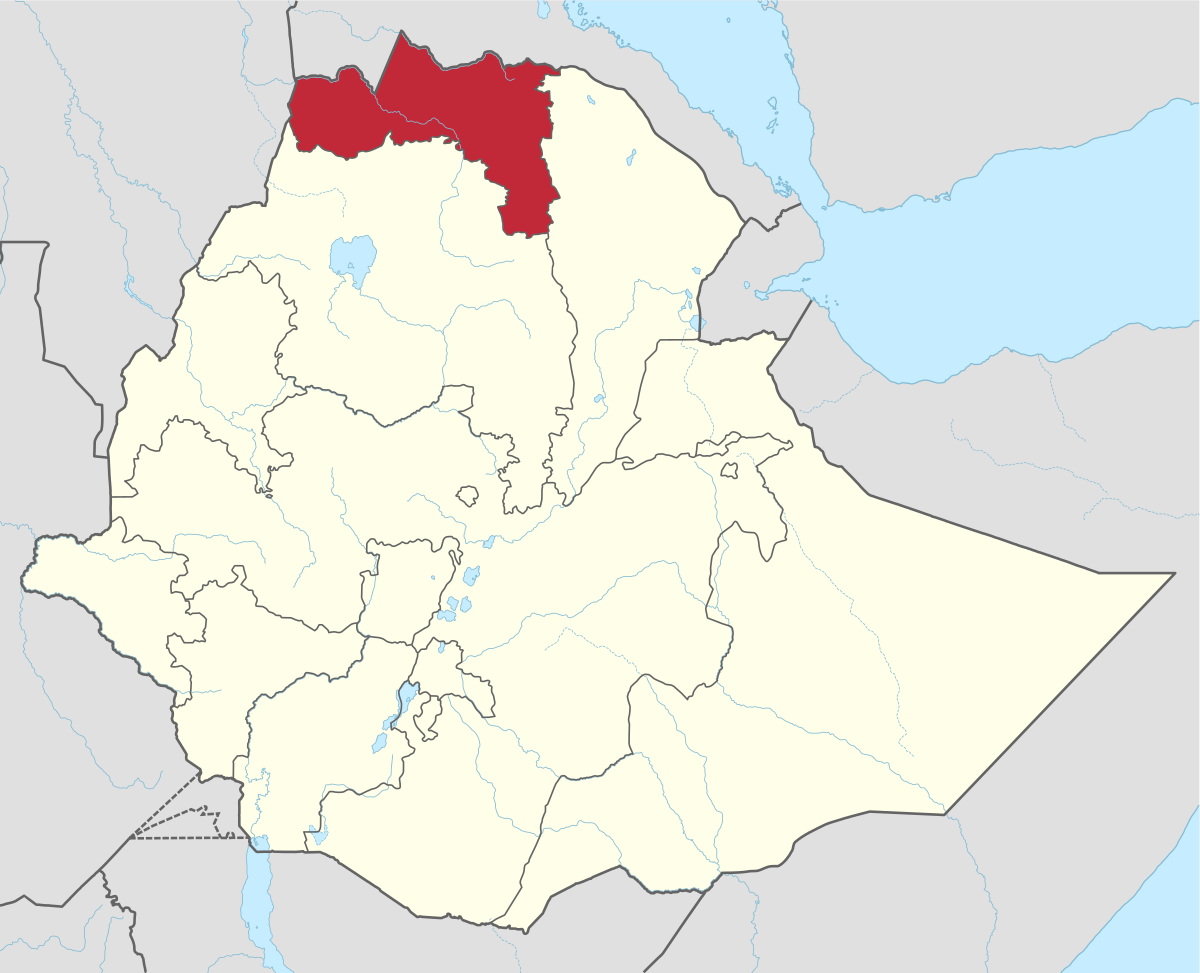
Tigray region

Tigray is a red region.

ghy.png

Historical Map of the Tigray Region

tigray.png

I will start with the area where the principality of Midri Bahr originated, it included the historical regions of Hamasien, Serae and Akele Guzai .(Midri Bahr)
If we only used these historical locations, the country would only have three locations.

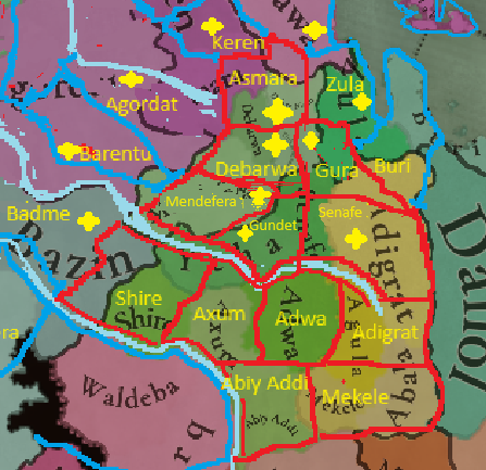
I counted as many as six cities that were part of northern Tigray (Midri Bahr), unfortunately I cannot read two cities. The cities are Asmara, Debarwa, Mendefera, Senafe.
I think there is no need to add any new provinces here, just redraw the region's borders to match the historical ones.
The historical division of Tigray should also be maintained. The Mereb River divided this region into two parts.
quote
In the 11th century the Tigrinya-speaking lands (Tigray-Mareb Melash) were divided into two provinces, separated by the Mereb River, by the newly enthroned Agaw emperors. The governor of the northern province received the title Bahre Negash (Ruler of the sea), whereas the governor of the southern province was given the title of Tigray Mekonen (Lord of Tigray). The Portuguese Jesuit Emanuele Baradas's work titled "Do reino de Tigr", written in 1633–34, states that the "Reino de Tigr" (Kingdom of Tigray) extended from Hamasien to Temben, from the borders of Dankel to the Adwa

As for the south of the region, I counted as many as 8 locations, i.e. Shire, Axum, Adwa, Agula, Mekele, Abala, Adigrat and Abi Addi ?.

It seems that all the important cities are there, although I think it would be better to replace the city of Abi Addi with the city of Melfa which was the first capital of the historical region of Tembien.

Regarding the political situation, I noticed that the Dhlak Sultanate is not present on the map. It should appear and take control of Dhlak Island and the location of Massawa.

In the 12th and 13th centuries Massawa it came under the control of the emir of Dahlak , who took the title sultan. The emir had formerly been an Axumite governor and was still referred to by the Ethiopians as seyuma bahr (Prefect of the Sea) as opposed to bahr negus (Lord of the Maritime Province, based at Debarwa). The emir (sultan) was represented in Massawa by a naib , whose relations with Ethiopia were conflictual. Isaac, son of Emperor David I (around 1381-1410), conquered the port around 1400 .


Descriptions of the Beja kingdoms that we have on the map.


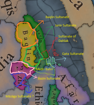
Baqlin Sultanate 700 — 1557
The Baqlin sultanate straddled the Rora valley (in the Sudan) and stretched to the Eastern slope of the Eritrean highlands. The Baqlin sultanate, along with its neighboring sultanates were the result of an invasion of Beja from Sudan but intermingled without imposing a new culture. The Baqlin were a semi-nomadic sultanate that raised and sold camels and cattle to its neighbors. The cause of decline of this Beja kingdom is unknown, however, in 1557 it succumbed to the Ottoman Empire.
Qata Sultanate 700 — 1557
The Qata sultanate was located from just south of Massawa to beyond Adulis and the Gulf of Zula near the Buri Peninsula. The primary commercial activity of this sultanate was mining and slave trade through the Dahlak sultanate out of the African interior to the Arabian peninsula and beyond. The ultimate cause of decline of this Beja kingdom, in the 16th century, is unknown, however, the constant warfare with its neighbors in pursuit of the slave trade, coupled with attacks by the Portuguese, weakened the sultanate. In 1557 it succumbed to the Ottoman Empire.

Jarin Sultanate 700 — 1557

Jarin sultanate (kingdom) stretched from the Barka valley in the west to the Massawa in the east. The Jarin sultanate, along with its neighboring sultanates were the result of an invasion of Beja from Sudan, particularly near the Nile valley, but also an intermingling without an imposition of a new culture. The primary commercial activity of this sultanate was mining and slave trade through the Dahlak sultanate out of the African interior to the Arabian peninsula and beyond. The cause of decline of this Beja kingdom, in the 14th century, is unknown, as with its neighbors. The most likely explanation is the slave trade that they were engaged in likely caused continuous war with its neighbors which eventually depleted the sultans control of their respective region. Which coupled with the rise of the Belew kingdom to the east and the rise of the Ottoman empire on the coast finally led to capitulation. In 1557 the Ottoman empire decisively moved in throughout the Eritrean coast, adding the Qata and Baqlin sultanate's as well.

Bazin Sultanate 700 — 1400
The Bazen sultanate was located in the western lowlands of Eritrea. The Bazen were primarily sedentary cultivators, meaning non-nomadic. In spite of the Beja rule, mass conversion of the indigenous population did not take place and they retained their faith to local religions. The cause of decline of this Beja kingdom, in the 14th century, is unknown however it occurred coincident with the rise of the Belew Kingdom. This Kingdom stretched from central Sudan and throughout the lowlands of Eritrea.

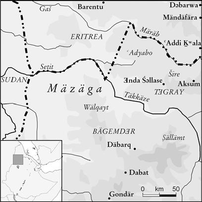
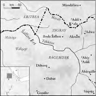
I propose adding the Mazaga Sultanate to the game.
This kingdom was probably founded by Arabs who mixed with the Beja people and took over their culture and language.
(Gabail Ukhra)
Gabail Ukhra are mostly Arab intruders in the Beja traditional country, but made good their position by marrying the Beja women and adapting

Changes on the political map.
-Adding the Dahlak Sultanate.
- Improved the location of the Medri Bahri Kingdom
- Changing the location of the Jarin Sultanate from the coast to the center of the Barka region.
- Proposal to Add the Mazaga Sultanate.

ghhh.png

ExUtYu5WEAEkVPc.jpg

Menelik_campaign_map_1_3-es.svg.png
 
Last edited:
  • 19Like
  • 7
  • 1Love
Reactions:
Tigray region

Tigray is a red region.

View attachment 1178823
Historical Map of the Tigray Region

View attachment 1178826
I will start with the area where the principality of Midri Bahr originated, it included the historical regions of Hamasien, Serae and Akele Guzai .(Midri Bahr)
If we only used these historical locations, the country would only have three locations.

I counted as many as six cities that were part of northern Tigray (Midri Bahr), unfortunately I cannot read two cities. The cities are Asmara, Debarwa, Mendefera, Senafe.
I think there is no need to add any new provinces here, just redraw the region's borders to match the historical ones.
The historical division of Tigray should also be maintained. The Mereb River divided this region into two parts.
quote
In the 11th century the Tigrinya-speaking lands (Tigray-Mareb Melash) were divided into two provinces, separated by the Mereb River, by the newly enthroned Agaw emperors. The governor of the northern province received the title Bahre Negash (Ruler of the sea), whereas the governor of the southern province was given the title of Tigray Mekonen (Lord of Tigray). The Portuguese Jesuit Emanuele Baradas's work titled "Do reino de Tigr", written in 1633–34, states that the "Reino de Tigr" (Kingdom of Tigray) extended from Hamasien to Temben, from the borders of Dankel to the Adwa

As for the south of the region, I counted as many as 8 locations, i.e. Shire, Axum, Adwa, Agula, Mekele, Abala, Adigrat and Abi Addi ?.

It seems that all the important cities are there, although I think it would be better to replace the city of Abi Addi with the city of Melfa which was the first capital of the historical region of Tembien.

Regarding the political situation, I noticed that the Dhlak Sultanate is not present on the map. It should appear and take control of Dhlak Island and the location of Massawa.

In the 12th and 13th centuries Massawa it came under the control of the emir of Dahlak , who took the title sultan. The emir had formerly been an Axumite governor and was still referred to by the Ethiopians as seyuma bahr (Prefect of the Sea) as opposed to bahr negus (Lord of the Maritime Province, based at Debarwa). The emir (sultan) was represented in Massawa by a naib , whose relations with Ethiopia were conflictual. Isaac, son of Emperor David I (around 1381-1410), conquered the port around 1400 .


Descriptions of the Beja kingdoms that we have on the map.


Baqlin Sultanate 700 — 1557
The Baqlin sultanate straddled the Rora valley (in the Sudan) and stretched to the Eastern slope of the Eritrean highlands. The Baqlin sultanate, along with its neighboring sultanates were the result of an invasion of Beja from Sudan but intermingled without imposing a new culture. The Baqlin were a semi-nomadic sultanate that raised and sold camels and cattle to its neighbors. The cause of decline of this Beja kingdom is unknown, however, in 1557 it succumbed to the Ottoman Empire.

Qata Sultanate 700 — 1557
The Qata sultanate was located from just south of Massawa to beyond Adulis and the Gulf of Zula near the Buri Peninsula. The primary commercial activity of this sultanate was mining and slave trade through the Dahlak sultanate out of the African interior to the Arabian peninsula and beyond. The ultimate cause of decline of this Beja kingdom, in the 16th century, is unknown, however, the constant warfare with its neighbors in pursuit of the slave trade, coupled with attacks by the Portuguese, weakened the sultanate. In 1557 it succumbed to the Ottoman Empire.

Jarin Sultanate 700 — 1557

Jarin sultanate (kingdom) stretched from the Barka valley in the west to the Massawa in the east. The Jarin sultanate, along with its neighboring sultanates were the result of an invasion of Beja from Sudan, particularly near the Nile valley, but also an intermingling without an imposition of a new culture. The primary commercial activity of this sultanate was mining and slave trade through the Dahlak sultanate out of the African interior to the Arabian peninsula and beyond. The cause of decline of this Beja kingdom, in the 14th century, is unknown, as with its neighbors. The most likely explanation is the slave trade that they were engaged in likely caused continuous war with its neighbors which eventually depleted the sultans control of their respective region. Which coupled with the rise of the Belew kingdom to the east and the rise of the Ottoman empire on the coast finally led to capitulation. In 1557 the Ottoman empire decisively moved in throughout the Eritrean coast, adding the Qata and Baqlin sultanate's as well.

Bazin Sultanate 700 — 1400
The Bazen sultanate was located in the western lowlands of Eritrea. The Bazen were primarily sedentary cultivators, meaning non-nomadic. In spite of the Beja rule, mass conversion of the indigenous population did not take place and they retained their faith to local religions. The cause of decline of this Beja kingdom, in the 14th century, is unknown however it occurred coincident with the rise of the Belew Kingdom. This Kingdom stretched from central Sudan and throughout the lowlands of Eritrea.

I propose adding the Mazaga Sultanate to the game.
This kingdom was probably founded by Arabs who mixed with the Beja people and took over their culture and language.
(Gabail Ukhra)
Gabail Ukhra are mostly Arab intruders in the Beja traditional country, but made good their position by marrying the Beja women and adapting

Changes on the political map.
-Adding the Dahlak Sultanate.
- Improved the location of the Medri Bahri Kingdom
- Changing the location of the Jarin Sultanate from the coast to the center of the Barka region.
- Proposal to Add the Mazaga Sultanate.

View attachment 1178866
If the Jarin sultanate moves south who takes over the former coast where Jarin currently is?
 
  • 1
Reactions:
O i had assumed that all pops outside of settled nations would belong to a society of people. Apparently not and there is still empty land and unattached pops
I don't see that there are "empty" proivinces as a problem but the sheer amount of them. That is a lot of empty provinces.
WOOOOO MARSHES RENAMED TO WETLANDS LETS GOOOOO
Oh I did not realize that, awesome.
Why bedouin tribes arent society of pops in central arabia?
They werent really settled and it doesnt make sense for Mamluks or Ottomans to conquer them like normal conquest

It does zero sense making all tribal groups society of pops and not visible political borders then making Arabic tribes settled on map
Maybe they're army based countries?
Not currently.
Well that's something of a problem considering how empty this map is. What do you expect to happen to the empty provinces? Will the local powers colonize them? Will they be settled by your societies of pops? Willl tey be colonized by Europeans? What is the point of having them?
Unironically, I find the Great Lakes region very interesting. It's an underrated part of Africa, but you're right lol
In EU4 sure but I can't see it being intresting in... eh... project Caesar.
IDK exactly yet how many there will be compared to EU4. But you also have to take into account that this game started a century before, so there might be some peoples who would have much more complex societies in 1444 compared to 1337.
Then give us a way to get from point A to point B. Just because these areas were "empty" in 1337 doesn't mean they should remain so in 1820.
Will new societies of pops appear over time, then? My concern is the 1337 situation being crystallized even over centuries of societal development and growing complexity in many regions.
Even some random events which takes pops of a culture and spawns a tag for them would be a huge improvements.


Have you considered sub-dividing the climate even further?? I imagine that Belarus and Russia would have way more severe winters that for example Bohemia or Hungary, and yet they are all classified as 'Continental'.. I really want climate to be a significant factor in the game as it would have been historically.. Stuff like frozen rivers in the winter and a shorter growing season for crops are things which has historically played a big part in why Russia had a harder time developing than Western Europe.. I just feel like a complex climate system(coupled with complex terrain) would be very beneficial for the game..
Very much seconded. While mountainous climates are similar to those further north, coastal climates do not strictly speaking work the opposite way, they have milder winters yes but they also have less hot summers. They need to rethink how they treat coastal climates. I would reccomend a set of climates which are only used relatively close to the coast and which are pretty much always used relatively close to the coast.
Signed you friendly neighbourhood Ecosystem engineer.

For a place with tons of history and cultures, I'm surprised there's less locations than the British Isles and the British Isles are way smaller than the Horn of Africa.
Yeah, I just checked, the UK fits twice into Ethiopia alone.
Vaguely surprised nobody has brought this up but I don't think Lake Victoria or the area around it should be named that at this time

I'd rename the provinces north of the lake after local villages or people and the lake itself has a number of names: Ukerewe from Swahili and Nyanza from Kinyarwanda make the most sense to me. They both have problems with not being universal terms among local languages but both are significantly better options than a British monarch who likely didn't live during the period of the game
Oh nice catch.
Pardon my ignorance, but what does "sturdy grains" represent? I figure non-cereal grains (in this region I assume it's representing lovegrass specifically)?
Also what would "medicaments" represent? Ingredients for medicine (be it traditional medicine or what little you can call actual medicine at this time)?
Don't know in africa but in Europe probavbly Barley and Rhye.
View attachment 1178829
Is that the name? If so I got an Achievement idea. Start as Mog and conquer x amount of states of southern Germany. Achievement called: Ik mog di so.
I was thinking something about them and Magog... but wait that's Gog and Magog isn't it?
 
Last edited:
  • 1Like
  • 1
Reactions:
Tigray region

Tigray is a red region.

View attachment 1178823
Historical Map of the Tigray Region

View attachment 1178826
I will start with the area where the principality of Midri Bahr originated, it included the historical regions of Hamasien, Serae and Akele Guzai .(Midri Bahr)
If we only used these historical locations, the country would only have three locations.

I counted as many as six cities that were part of northern Tigray (Midri Bahr), unfortunately I cannot read two cities. The cities are Asmara, Debarwa, Mendefera, Senafe.
I think there is no need to add any new provinces here, just redraw the region's borders to match the historical ones.
The historical division of Tigray should also be maintained. The Mereb River divided this region into two parts.
quote
In the 11th century the Tigrinya-speaking lands (Tigray-Mareb Melash) were divided into two provinces, separated by the Mereb River, by the newly enthroned Agaw emperors. The governor of the northern province received the title Bahre Negash (Ruler of the sea), whereas the governor of the southern province was given the title of Tigray Mekonen (Lord of Tigray). The Portuguese Jesuit Emanuele Baradas's work titled "Do reino de Tigr", written in 1633–34, states that the "Reino de Tigr" (Kingdom of Tigray) extended from Hamasien to Temben, from the borders of Dankel to the Adwa

As for the south of the region, I counted as many as 8 locations, i.e. Shire, Axum, Adwa, Agula, Mekele, Abala, Adigrat and Abi Addi ?.

It seems that all the important cities are there, although I think it would be better to replace the city of Abi Addi with the city of Melfa which was the first capital of the historical region of Tembien.

Regarding the political situation, I noticed that the Dhlak Sultanate is not present on the map. It should appear and take control of Dhlak Island and the location of Massawa.

In the 12th and 13th centuries Massawa it came under the control of the emir of Dahlak , who took the title sultan. The emir had formerly been an Axumite governor and was still referred to by the Ethiopians as seyuma bahr (Prefect of the Sea) as opposed to bahr negus (Lord of the Maritime Province, based at Debarwa). The emir (sultan) was represented in Massawa by a naib , whose relations with Ethiopia were conflictual. Isaac, son of Emperor David I (around 1381-1410), conquered the port around 1400 .


Descriptions of the Beja kingdoms that we have on the map.


Baqlin Sultanate 700 — 1557
The Baqlin sultanate straddled the Rora valley (in the Sudan) and stretched to the Eastern slope of the Eritrean highlands. The Baqlin sultanate, along with its neighboring sultanates were the result of an invasion of Beja from Sudan but intermingled without imposing a new culture. The Baqlin were a semi-nomadic sultanate that raised and sold camels and cattle to its neighbors. The cause of decline of this Beja kingdom is unknown, however, in 1557 it succumbed to the Ottoman Empire.
Qata Sultanate 700 — 1557
The Qata sultanate was located from just south of Massawa to beyond Adulis and the Gulf of Zula near the Buri Peninsula. The primary commercial activity of this sultanate was mining and slave trade through the Dahlak sultanate out of the African interior to the Arabian peninsula and beyond. The ultimate cause of decline of this Beja kingdom, in the 16th century, is unknown, however, the constant warfare with its neighbors in pursuit of the slave trade, coupled with attacks by the Portuguese, weakened the sultanate. In 1557 it succumbed to the Ottoman Empire.

Jarin Sultanate 700 — 1557

Jarin sultanate (kingdom) stretched from the Barka valley in the west to the Massawa in the east. The Jarin sultanate, along with its neighboring sultanates were the result of an invasion of Beja from Sudan, particularly near the Nile valley, but also an intermingling without an imposition of a new culture. The primary commercial activity of this sultanate was mining and slave trade through the Dahlak sultanate out of the African interior to the Arabian peninsula and beyond. The cause of decline of this Beja kingdom, in the 14th century, is unknown, as with its neighbors. The most likely explanation is the slave trade that they were engaged in likely caused continuous war with its neighbors which eventually depleted the sultans control of their respective region. Which coupled with the rise of the Belew kingdom to the east and the rise of the Ottoman empire on the coast finally led to capitulation. In 1557 the Ottoman empire decisively moved in throughout the Eritrean coast, adding the Qata and Baqlin sultanate's as well.

Bazin Sultanate 700 — 1400
The Bazen sultanate was located in the western lowlands of Eritrea. The Bazen were primarily sedentary cultivators, meaning non-nomadic. In spite of the Beja rule, mass conversion of the indigenous population did not take place and they retained their faith to local religions. The cause of decline of this Beja kingdom, in the 14th century, is unknown however it occurred coincident with the rise of the Belew Kingdom. This Kingdom stretched from central Sudan and throughout the lowlands of Eritrea.

I propose adding the Mazaga Sultanate to the game.
This kingdom was probably founded by Arabs who mixed with the Beja people and took over their culture and language.
(Gabail Ukhra)
Gabail Ukhra are mostly Arab intruders in the Beja traditional country, but made good their position by marrying the Beja women and adapting

Changes on the political map.
-Adding the Dahlak Sultanate.
- Improved the location of the Medri Bahri Kingdom
- Changing the location of the Jarin Sultanate from the coast to the center of the Barka region.
- Proposal to Add the Mazaga Sultanate.

View attachment 1178866
1724522001347.png

Gundet (https://en.wikipedia.org/wiki/Battle_of_Gundet): That's in Seraye, can be used to specify the large Mendefera blob
1724522054952.png
 
  • 5Like
  • 1
Reactions:
Has there been any discussion around splitting up the Somali's along their clan lines? Also I found a pretty interesting thread suggesting changes to EU4 Somalia, though it's focused on 1444 it has a lot of information that should still be applicable.

View attachment 1178474
I disagree. I think it would make more sense to have the clans remain as a part of an internal faction mechanic with a bunch of suitable events. This would increase the complexity of the region and add depth to gameplay, as well as allow the player to simulate having to play the clans off each other. This clan mechanic could also be used in many other clan based societies around the world. Other clan based societies like Ireland, Scotland, and Japan haven't had their cultures split apart based on clans in the game, and it doesn't make sense for the Somali region as well. While clans and lineage are important to their respective cultures, the clans are a system of groups within a culture based on identification via patrilinear descent, not actual cultures in and of themselves.
 
  • 1
  • 1
  • 1Like
Reactions:
To let you know, this is the criterion we've been using to assign people to the different tag categories:
Very disappointed. I was under the impression that the point of societies of pops was to embody the real nationhood of these civilizations and their dynamic interactions with other nations and states, but now you're defeating that purpose by continuing to otherize indigenous communities and belittle their history as sovereign nations by framing them as static obstacles to inevitably be steamrolled by imperialist powers. I really dislike the apparent inability of the devs to break free of this implicitly colonialist view of the world. These peoples were not just lawless hordes of savages awaiting the light of European civilization, they were robust societies with law, trade, power structures, and complex interactions with other states and societies. Even purely hunter-gatherer societies were this complex, such as the Calusa Kingdom of south Florida.

I would urge the devs to reconsider this system and implement all nations as the dynamic players in history that they were.
 
  • 8Like
  • 5
  • 4
  • 1
Reactions:
Last edited:
  • 3Like
  • 1
  • 1
Reactions: