• We have updated our Community Code of Conduct. Please read through the new rules for the forum that are an integral part of Paradox Interactive’s User Agreement.

Tinto Maps #17 - 6th of September 2024 - Arabia

Hello everyone, and welcome to one more developer diary for map lovers! This is the second this week, after the review of Poland, Ruthenia, and the Baltic. Hurray!

Today we will be taking a look at the lands of Arabia! So let’s start, without further ado:

Countries:
Countries.png

Colored Wastelands.png
This week, we have two country maps: one without colored wastelands for clarity, and one with them under the spoiler button. You might also wonder why there isn’t a third one with the Societies of Pops for the region. Well, that’s because Project Caesar has several layers to portray the simulation of a believable world (if you remember, one of our design pillars). A couple of weeks we presented the Societies of Pops as a new type of country, but if you go back to Tinto Talks #4, the Government Overview, Johan mentioned the different types of governments, which now you know are for Settled Countries. One of them is Tribal, which we think makes for a good representation of the most complex and organized tribal societies, which have some estate-like features while keeping some other tribal features.

Therefore, the way we’ve decided that fits better to portray the simulation of the Arabian Peninsula is having a divide between those countries that are Monarchies (Mecca, Yemen, Oman, Ormus, and the Jarwanids), and those that are Tribal (the rest of them). An interesting feature of the latter is that their lands will be full of Tribesmen pops, making the Tribal estate the most important one to manage. As a final note, I’d like you to understand that this is our interpretation for the simulation of the game, although it might not be the only one (as it happened with the discussions about which European countries should be decentralized with several subjects, and which shouldn’t). The good news regarding this is that we will be open to feedback and making changes, as usual; but also, that this setup can easily be changed through the script of the game, thus making it completely moddable after the game is released; so there could potentially be mods making inner Arabia covered by Societies of Pops instead of Tribal Settled countries, if you don’t like/agree with our interpretation, or just prefer it to be different.


Dynasties:
Dynasties.png

Among the dynasties of the region, you might find some old acquaintances, such as the Rasulids of Yemen or the Nabhani of Oman, while also having a bunch of new ones. And not a week without a bug, of course: the ‘al-Al’ prefix is an error, as those dynasties are using a locative, which is mixed with a second one, from the location; we will have that fixed, then.

Locations:
Locations.png

Locations 2.png

Locations 3.png

Locations 4.png
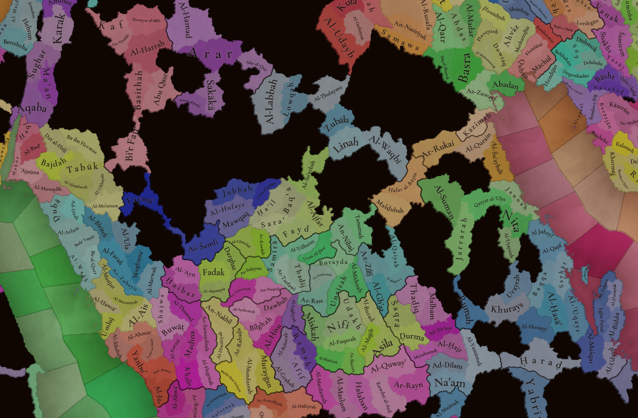
The locations of the region, with more detailed maps under the spoiler button for three different sections (Northern and Central Arabia, Southern Arabia, and Eastern Arabia).

Provinces:
Provinces.png


Areas:
Areas.png


Terrain:
Climate.png

Topography.png

Vegetation.png

You might notice that most of Arabia is an arid, desertic plateau. The only exception to this is some fertile mountain valleys in Yemen, which was known as Eudaimon Arabia/Arabia Felix for a reason.

Natural Harbors:
Harbors.png


Cultures:
Cultures.png

The cultural division of the region is quite interesting, as it’s divided into several Arabic-speaking people. And for those that might wonder, yes, Socotra has its own culture, Soqotri. We still have to add some minorities here and there, though, so we will take the opportunity to do it during the map review.

Religions:
Religions.png

The religious division of Arabia is also interesting, having Sunni, Shiite, and Ibady majorities spread across the peninsula. We have yet to address the minorities, which were not ready for the Tinto Maps, so we will show what that looks like on the map, and review as well. By the way, we might do some work in the coming weeks regarding Islam, and one of the things that I think we may tweak is the coloring, as Ibadi is too similar to Shiite; so I think that this might be a good opportunity to ask for your preferences about the coloring of the different branches of the Islamic faith.

Raw Materials:
Raw Materials.png

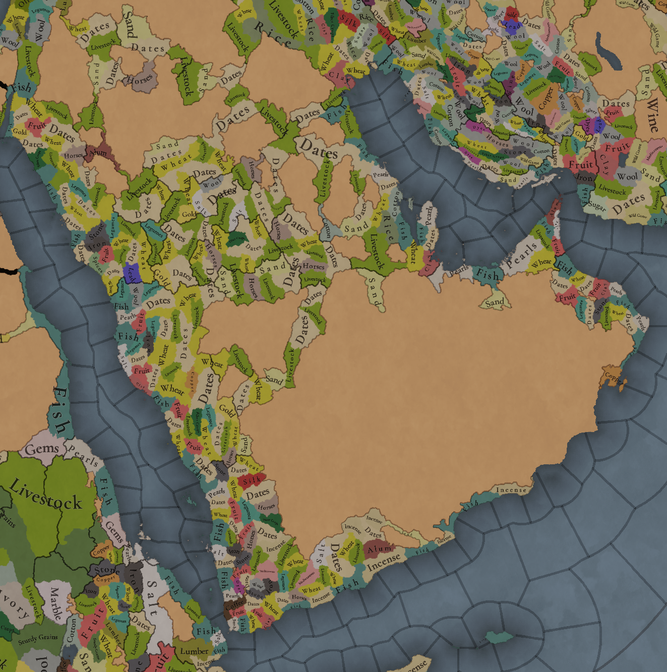
Dates, livestock, horses, and some wheat and sand make for a healthy economy if you’re a Tribal country, I guess? Jokes aside, the desertic lands of Northern and Central Arabia have a more simple resource distribution, while Yemen and Oman, on the other hand, have quite rich resources, such as Pearls, Alum, Copper, Dyes, Silk, and Coffee (who doesn’t like a good mocha?).

Markets:
Markets.png

There are five market centers present in this region: Mecca, Al-Hajar, Al-Hasa’, Hormoz, and ‘Adan. Coupled with the resources in the previous section, the control over ‘Adan and Hormoz will be strategically relevant, as it was historically.

Population:
Population.png

Population 2.png

Population 3.png

Population 4.png
This week there aren’t (almost) issues with the population of the region, so we’re able to show it to you. The entire region has around 4.5M pops, which are unevenly distributed; Yemen has 1.6M, and Mecca 776K, making for more than half of the total, while a good chunk of it belongs to the Mamluks (that control all the area around Madina.

And that’s all for this week! For the next one, I have good news: we have finished the feedback review of Anatolia, and therefore I’ll post it on Monday! That way it will make for a week without a Tinto Talks more bearable. And on Friday, there will be maps for a new region, Iran and the Caucasus! See you!
 
  • 143Like
  • 33Love
  • 3
  • 3
  • 2
Reactions:
Ok, question: why is the Ad-Dahna a traversable desert but the southeast of the peninsula isn't?

Waaaaay back in 2017, I made a thread for Arabia in EU4, based on a 2016 thread from a known modder. The main motivator for the thread was the Ad-Dhana desert/wasteland, as pointed out by Urdnot_scott themself:

As others have pointed out, the lack of connection between inner Arabia and Bahrain/Oman is very deliberate for two main reasons.

1. The first is geographic. Coastal Eastern Arabia is seperated from the rest of the subcontinent by Saudi Arabia's 3 great deserts, the Rub' Al Khali in the south, the An Nefud in the north, and the long strip of burning sand which joins the two called the Ad-Dhana. Deserts come in a lot of shapes and sizes, not all of them are just scorching expanses of nothingness - most of the subcontinent is desert, yeah, but its the kind of desert with dirt, rock, grass, some water, trees - things needed for any sort of ecosystem. The 3 great deserts have none of those things, they're 'ergs'. Ergs are literally just sand. Nothing else. Its incredibly difficult for even a caravan to pass through them let alone an army! Portugal and Britain controlled the eastern coast throughout the time period but never managed to extend their influence into the interior - those 3 ergs is pretty much why. Additionally, a large mountain range (the Twaik range) separates Ahsaa from the rest of the peninsula. The combination of these ergs and the mountains make it pretttyy much impossible to cross the peninsula with a large force for most of the games period.

2. The second is for gameplay. Oman, Bahrain, Portugal and the UK all had bases along the east coast, they were powerful states which dwarfed the tiny tribes of the interior but didn't project their power inside, they looked outward. India, Persia and Africa all became targets for these big maritime empires and ingame that's what we should be pushing them towards. The Arabian coast is a great stop-off for anyone looking to colonise the East and controlling the Aden node is pretty useful for anyone trying to get their trade back to Europe. Therefore a colonial power, native or otherwise, can dominate Eastern Arabia without being politically involved with the interior at all. It makes it way harder to control the interior, right now whoever controls Iraq ends up pushing into Arabia and vassalizing everyone, or Ahsaa goes crazy and annexes half the peninsula - this makes no sense! The 2 colonisable provinces in the modern day UAE mean a colonial power like the UK or Portugal doesn't need to do a no-CB war against Oman or Yemen just to control the Aden node but can colonise the areas they historically did and not end up owning the whole peninsula. I for one don't want to see a huge Portuguese Arabia - this version limits the Europeans to little bases on the east coast just like in reality!

This did not stop people from questioning my design choices, so in the end I brought up Annali dell'Islam.

What the book gave me back then was that, at best, you got a 300-man army crossing the Ad-Dahna from Najd to Bahrein, and in extremely terrible conditions they only got themselves out of by divine intervention. This is relevant because the base regiment in EU4 had 1000 men, which means you did not have proper army regiments crossing the Ad-Dahna in the time period, or even in the Middle Ages. Project Caesar, however, can have smaller armies (iirc the base is 100 men?), so maybe in this game it could be traversable at extreme attrition. But I'd still err towards making the location(s) a wasteland.

Regardless, this is the ad-Dahna, and I could see it going either way. But why was the Rub' al-Khali extended all the way to the coast? I don't recall reading anything back then about that part of the coast being uninhabitable. The Dhofar Governorate was part of the Kathiri and then of Oman according to Wikipedia; by the map, Oman will have to hop through the wasteland to get to it (the wasteland covers the easternmost third of the Dhofar coast). Al-Wusta (the wasteland covers the westernmost two-thirds of its coast) is a bit harder to justify using only Wikipedia, but Dhofar being Omani territory really makes a wasteland Al-Wusta a complicated idea. At the very worst, they should be a corridor. Or just make it a location called Duqm and pretend there were only half a dozen camels and fishermen there.
 
Last edited:
  • 11Like
  • 1
Reactions:
Hello everyone, and welcome to one more developer diary for map lovers! This is the second this week, after the review of Poland, Ruthenia, and the Baltic. Hurray!

Today we will be taking a look at the lands of Arabia! So let’s start, without further ado:

Countries:
View attachment 1184278
This week, we have two country maps: one without colored wastelands for clarity, and one with them under the spoiler button. You might also wonder why there isn’t a third one with the Societies of Pops for the region. Well, that’s because Project Caesar has several layers to portray the simulation of a believable world (if you remember, one of our design pillars). A couple of weeks we presented the Societies of Pops as a new type of country, but if you go back to Tinto Talks #4, the Government Overview, Johan mentioned the different types of governments, which now you know are for Settled Countries. One of them is Tribal, which we think makes for a good representation of the most complex and organized tribal societies, which have some estate-like features while keeping some other tribal features.

Therefore, the way we’ve decided that fits better to portray the simulation of the Arabian Peninsula is having a divide between those countries that are Monarchies (Mecca, Yemen, Oman, Ormus, and the Jarwanids), and those that are Tribal (the rest of them). An interesting feature of the latter is that their lands will be full of Tribesmen pops, making the Tribal estate the most important one to manage. As a final note, I’d like you to understand that this is our interpretation for the simulation of the game, although it might not be the only one (as it happened with the discussions about which European countries should be decentralized with several subjects, and which shouldn’t). The good news regarding this is that we will be open to feedback and making changes, as usual; but also, that this setup can easily be changed through the script of the game, thus making it completely moddable after the game is released; so there could potentially be mods making inner Arabia covered by Societies of Pops instead of Tribal Settled countries, if you don’t like/agree with our interpretation, or just prefer it to be different.


Dynasties:
View attachment 1184281
Among the dynasties of the region, you might find some old acquaintances, such as the Rasulids of Yemen or the Nabhani of Oman, while also having a bunch of new ones. And not a week without a bug, of course: the ‘al-Al’ prefix is an error, as those dynasties are using a locative, which is mixed with a second one, from the location; we will have that fixed, then.

Locations:
View attachment 1184282
The locations of the region, with more detailed maps under the spoiler button for three different sections (Northern and Central Arabia, Southern Arabia, and Eastern Arabia).

Provinces:
View attachment 1184286

Areas:
View attachment 1184287

Terrain:
View attachment 1184288
View attachment 1184289
View attachment 1184290
You might notice that most of Arabia is an arid, desertic plateau. The only exception to this is some fertile mountain valleys in Yemen, which was known as Eudaimon Arabia/Arabia Felix for a reason.

Natural Harbors:
View attachment 1184291

Cultures:
View attachment 1184293
The cultural division of the region is quite interesting, as it’s divided into several Arabic-speaking people. And for those that might wonder, yes, Socotra has its own culture, Soqotri. We still have to add some minorities here and there, though, so we will take the opportunity to do it during the map review.

Religions:
View attachment 1184294
The religious division of Arabia is also interesting, having Sunni, Shiite, and Ibady majorities spread across the peninsula. We have yet to address the minorities, which were not ready for the Tinto Maps, so we will show what that looks like on the map, and review as well. By the way, we might do some work in the coming weeks regarding Islam, and one of the things that I think we may tweak is the coloring, as Ibadi is too similar to Shiite; so I think that this might be a good opportunity to ask for your preferences about the coloring of the different branches of the Islamic faith.

Raw Materials:
View attachment 1184295
Dates, livestock, horses, and some wheat and sand make for a healthy economy if you’re a Tribal country, I guess? Jokes aside, the desertic lands of Northern and Central Arabia have a more simple resource distribution, while Yemen and Oman, on the other hand, have quite rich resources, such as Pearls, Alum, Copper, Dyes, Silk, and Coffee (who doesn’t like a good mocha?).

Markets:
View attachment 1184296
There are five market centers present in this region: Mecca, Al-Hajar, Al-Hasa’, Hormoz, and ‘Adan. Coupled with the resources in the previous section, the control over ‘Adan and Hormoz will be strategically relevant, as it was historically.

Population:
View attachment 1184297
This week there aren’t (almost) issues with the population of the region, so we’re able to show it to you. The entire region has around 4.5M pops, which are unevenly distributed; Yemen has 1.6M, and Mecca 776K, making for more than half of the total, while a good chunk of it belongs to the Mamluks (that control all the area around Madina.

And that’s all for this week! For the next one, I have good news: we have finished the feedback review of Anatolia, and therefore I’ll post it on Monday! That way it will make for a week without a Tinto Talks more bearable. And on Friday, there will be maps for a new region, Iran and the Caucasus! See you!
I think ibadi should be a darker green it’s color is too similar to Shiite
 
  • 1
  • 1Like
  • 1
Reactions:
What the book gave me back then was that, at best, you got a 300-man army crossing the Ad-Dahna from Najd to Bahrein, and in extremely terrible conditions they only got themselves out of by divine intervention. This is relevant because the base regiment in EU4 had 1000 men, which means you did not have proper army regiments crossing the Ad-Dahna in the time period, or even in the Middle Ages. Project Caesar, however, can have smaller armies (iirc the base is 100 men?), so maybe in this game it could be traversable at extreme attrition. But I'd still err towards making the province(s) a wasteland.

There are examples of conquest of eastern Arabia from Inner Arabia. One by Rashidun in 7th century and one by Wahhabi in 18th century.


Regardless, this is the ad-Dahna, and I could see it going either way. But why was the Rub' al-Khali extended all the way to the coast? I don't recall reading anything back then about that part of the coast being uninhabitable. The Dhofar Governorate was part of the Kathiri and then of Oman according to Wikipedia; by the map, Oman will have to hop through the wasteland to get to it (the wasteland covers the easternmost third of the Dhofar coast). Al-Wusta is a bit harder to justify using only Wikipedia, but Dhofar being Omani territory really makes a wasteland Al-Wusta a complicated idea. At the very worst, they should be a corridor. Or just make it a location called Duqm and pretend there were only half a dozen camels and fishermen there.
I agree that Salalah (Dhofar) should be included, but due to its location, it is geographically cut off from Oman proper. I am not aware of any historical example of an army marching by land from Hadramaut to Oman or vice versa.

Dhofar only became part of Oman in the 19th century. The city is more of an extension of the Hadramaut region. As was typical for Oman at that time, it gained supremacy through its naval power. No Omani army marched across the land to conquer Dhofar.
 
Last edited:
  • 4Like
  • 1
Reactions:
  • In Eastern Arabia's 14th century, it was the Usfurids Emirate not Jarwanids as Jarwandis only came to rule Al-Hasa in 1392 and they lasted only until 1417.

  • Every tribe in the Arabian Interior should be Society of Pops, the best example of settled tribe should be Banu Hanifah (Who are currently not present on map) in Modern-day Riyadh or Hanifa Valley. Arabian tribes during that time were NOT organized societies, it was a period of lawlessness and instability that lasted till the first Saudi State (1774), though I agree with the choice of making Mecca, Yemen, Oman, Ormus, and the Jarwanids as monarchies since they had established Dynasties and had the most power within Arabia.

  • There should be some way to reach Dhofar from Oman by walking along the coast, the Empty Quarter doesn't stretch that far south.

  • In a previous Tinto Maps (Egypt) I mentioned that an exclusive "Bedouin" culture doesn't make sense, as Arabs can be Bedouins or sedentary, for example, Hejazi Bedouins or Najdi Bedouins. Having northwestern Arabia as Bedouins but not Hejazi is just wrong. The Bedoui culture you see in some Cultural maps of Egypt just means they live a nomadic lifestyle and are identical to the Bedouins in Arabia, In short, it's a lifestyle, not a culture.

  • Yas tribe (modern-day UAE) were never Shia'a and should be Sunni.
  • For the colors of Islamic sects, Maybe give Ibadi light blue and Sunni Dark Green. Shia could remain the same or orange like EU4.

  • Bahrain Island must produce Pearls as it was an integral part of their history pre-oil, and not Cotton lol.
 
  • 9Like
  • 5
Reactions:
Please leave either the Shiite or Ibadi color alone, they are both so beautiful. I personally prefer Ibadi and would like Shiite to be tweaked, but this Shiite is beautiful too.

On the topic of colors, this is a much better view of the new Zoroasterian color than the religion Tino Talk, and I'm loving this navy blue.
 
Dubai, Bahrain and muscat shouldn’t be black when it comes to natural harbors, also for Arab tribes their dynasties should just be the name of the tribe. I also think best way to simulate the history of the area and of Arab tribes is that they are all societies of pops but if one of the tribes build a fort, that forts zone of control is their new settled territory, but outside of the zone of control their lands are still unsettled,
 
  • 7Like
Reactions:
Hello everyone, and welcome to one more developer diary for map lovers! This is the second this week, after the review of Poland, Ruthenia, and the Baltic. Hurray!

Today we will be taking a look at the lands of Arabia! So let’s start, without further ado:

Countries:
View attachment 1184278
This week, we have two country maps: one without colored wastelands for clarity, and one with them under the spoiler button. You might also wonder why there isn’t a third one with the Societies of Pops for the region. Well, that’s because Project Caesar has several layers to portray the simulation of a believable world (if you remember, one of our design pillars). A couple of weeks we presented the Societies of Pops as a new type of country, but if you go back to Tinto Talks #4, the Government Overview, Johan mentioned the different types of governments, which now you know are for Settled Countries. One of them is Tribal, which we think makes for a good representation of the most complex and organized tribal societies, which have some estate-like features while keeping some other tribal features.

Therefore, the way we’ve decided that fits better to portray the simulation of the Arabian Peninsula is having a divide between those countries that are Monarchies (Mecca, Yemen, Oman, Ormus, and the Jarwanids), and those that are Tribal (the rest of them). An interesting feature of the latter is that their lands will be full of Tribesmen pops, making the Tribal estate the most important one to manage. As a final note, I’d like you to understand that this is our interpretation for the simulation of the game, although it might not be the only one (as it happened with the discussions about which European countries should be decentralized with several subjects, and which shouldn’t). The good news regarding this is that we will be open to feedback and making changes, as usual; but also, that this setup can easily be changed through the script of the game, thus making it completely moddable after the game is released; so there could potentially be mods making inner Arabia covered by Societies of Pops instead of Tribal Settled countries, if you don’t like/agree with our interpretation, or just prefer it to be different.


Dynasties:
View attachment 1184281
Among the dynasties of the region, you might find some old acquaintances, such as the Rasulids of Yemen or the Nabhani of Oman, while also having a bunch of new ones. And not a week without a bug, of course: the ‘al-Al’ prefix is an error, as those dynasties are using a locative, which is mixed with a second one, from the location; we will have that fixed, then.

Locations:
View attachment 1184282
The locations of the region, with more detailed maps under the spoiler button for three different sections (Northern and Central Arabia, Southern Arabia, and Eastern Arabia).

Provinces:
View attachment 1184286

Areas:
View attachment 1184287

Terrain:
View attachment 1184288
View attachment 1184289
View attachment 1184290
You might notice that most of Arabia is an arid, desertic plateau. The only exception to this is some fertile mountain valleys in Yemen, which was known as Eudaimon Arabia/Arabia Felix for a reason.

Natural Harbors:
View attachment 1184291

Cultures:
View attachment 1184293
The cultural division of the region is quite interesting, as it’s divided into several Arabic-speaking people. And for those that might wonder, yes, Socotra has its own culture, Soqotri. We still have to add some minorities here and there, though, so we will take the opportunity to do it during the map review.

Religions:
View attachment 1184294
The religious division of Arabia is also interesting, having Sunni, Shiite, and Ibady majorities spread across the peninsula. We have yet to address the minorities, which were not ready for the Tinto Maps, so we will show what that looks like on the map, and review as well. By the way, we might do some work in the coming weeks regarding Islam, and one of the things that I think we may tweak is the coloring, as Ibadi is too similar to Shiite; so I think that this might be a good opportunity to ask for your preferences about the coloring of the different branches of the Islamic faith.

Raw Materials:
View attachment 1184295
Dates, livestock, horses, and some wheat and sand make for a healthy economy if you’re a Tribal country, I guess? Jokes aside, the desertic lands of Northern and Central Arabia have a more simple resource distribution, while Yemen and Oman, on the other hand, have quite rich resources, such as Pearls, Alum, Copper, Dyes, Silk, and Coffee (who doesn’t like a good mocha?).

Markets:
View attachment 1184296
There are five market centers present in this region: Mecca, Al-Hajar, Al-Hasa’, Hormoz, and ‘Adan. Coupled with the resources in the previous section, the control over ‘Adan and Hormoz will be strategically relevant, as it was historically.

Population:
View attachment 1184297
This week there aren’t (almost) issues with the population of the region, so we’re able to show it to you. The entire region has around 4.5M pops, which are unevenly distributed; Yemen has 1.6M, and Mecca 776K, making for more than half of the total, while a good chunk of it belongs to the Mamluks (that control all the area around Madina.

And that’s all for this week! For the next one, I have good news: we have finished the feedback review of Anatolia, and therefore I’ll post it on Monday! That way it will make for a week without a Tinto Talks more bearable. And on Friday, there will be maps for a new region, Iran and the Caucasus! See you!
I don't know if this was already explained at some point but: Is there a map mode where you can see terrain and political borders at the same time? Like in Ck3. I really liked that.
 
An oceanic climate does not entirely rule out the possibility of freezing. For instance, The Netherlands, despite its oceanic climate, has seen several shallow bodies of water (narrow), such as the Waddenzee and the Zuiderzee, freeze on multiple occasions. Therefore, the ocean type of the English Channel should be reconsidered.
I never said it rules it out. I said winters tend to be mild in oceanic climates, not very severe (as team Tinto said it takes at least a week of "severe" winter hardness for narrows and inland seas to freeze over); it also seems that climate will only be one factor in winters, and there will be blending between ares (so for example the closer you get to a colder climate the colder your winters will get, so for example the Netherlands that is closer to continental and arctic areas will get colder winters than the British Islands.

That being said, recathegorizing the English Channel to Coastal Sea may make more sense. I think you should propose this on that Tinto Maps' thread
 
  • 1Like
Reactions:
I don't have a lot of knowledge in the region, but wasn't Mokha just the main coffee trading port, instead of the center of production of coffee? Maybe some inland locations should produce coffee instead, maybe around Sana'a (where coffee is currently planted).
It's present in two locations, Al-Mukha, and Ta'izz.
 
  • 12Like
  • 1
Reactions:
I guess most of those livestock provinces are actually camels, cattle are too thirsty to thrive there, swine are too haram (and probably too thirsty too), sheep are represented by wool production, and horses are separate.

Also, is the Sunni Ummah an I.O.?
1. Goats, camels, etc.
2. The Sunni mechanics are not yet fully implemented, but we're currently leaning towards having an IO only if a proper Caliphate is restored (because the Cairo Caliphs were not really recognized by anyone else but the Mamluks).
 
  • 20Like
Reactions:
The yemen region extends too far north. Also, the land corresponding to the modern day nation of Kuwait was a massive pearl fishing hub (albeit only coming into prominence later into game start) and I feel the trade good should be changed to represent that, same with muscat. Also, is it not possible to have a coastal desert location(?) feels strange to just staple the entire arabian peninsula as Desert. Much of the coastal areas were far more pleasant and thus more historically conducive to settled civilization rather than nomadic settlements.
 
"...so I think that this might be a good opportunity to ask for your preferences about the coloring of the different branches of the Islamic faith."

I have red-green colorblindness, and I can't distinguish all that many shades of green. For me, it's very difficult to differentiate the Shiite and Ibadi map colors. I did not realize Ibadi was on the map at all right away. I can easily distinguish the Sunni and Shiite map colors, though.

If I was the supreme God-Emperor of Paradox, I would request that my minions switch Ibadi to a shade that's much darker. Alternatively, a shade of green with significant yellow saturation would help.
This is really insightful for us, as we really want to make the game accessible for people with colorblindness, thanks a lot!
 
  • 27Like
Reactions:
Some notes on the harbors.
Muscat has an excellent, if small, port; that has to be an oversight. On the other hand, the arabian gulf coast is very shallow and filled with shoals and sand banks that are exposed at low tide, all the modern ports that you see today required very extensive dredging and land reclamation. The Persian side is a little better, although even Hormuz isnt that great of a port in itself, it owes its significance to its strategic location moreso than its harbor.
FInally the Shatt al-Arab should be navigable up to Basrah and the natural harbors at Abadan and Az Zuwayr should be moved to Basrah.
This is exactly the feedback we're looking for regarding natural harbors, thanks!
 
  • 31Like
Reactions: