• We have updated our Community Code of Conduct. Please read through the new rules for the forum that are an integral part of Paradox Interactive’s User Agreement.

Tinto Maps #18 - 13th of September 2024 - Persia & Caucasus

Hello everyone, and welcome to one more Tinto Maps! Today we will be taking a look at Persia and the Caucasus! These are regions that encompass several modern-day countries and regions (Iraq, Iran, Balochistan, Afghanistan, Transoxiana, etc.), but for the sake of simplicity, we decided to name this DD this. Let’s start, without further ado!

Countries:
Countries.png

Colored Wastelands.png

The region is quite interesting in 1337, as there are plenty of countries to play with. The Ilkhanate is still alive, but in name only, the real power being hosted by the Jalayirids, who are overlords of some of their neighbors (the Chobanids, and the Eretnids). Other countries, such as Gurgan, the Kartids, and Muzaffarids are also struggling to get the hegemony over the region. Meanwhile, the strongest power in the Caucasus is the Kingdom of Georgia, although the region is also quite fragmented among different polities.

Ilkhanate.png

And speaking of the Ilkhanate, you may have wondered why isn’t it a unified tag… Well, it’s because we consider that it is clearly in decadence, having lost any grasp of authority over the provinces, so the best way of portraying it is through an International Organization. What we can see in this mapmode is that there are two pretenders to get the power, the Jalayarids and Gurgan, with the other countries still being formally part of it. I won’t talk more today about how it works and its features, but I’ll just say that there are two clear fates for the Ilkhanate: being dissolved, as historically happened, or being restored in full power as a unified country.

Dynasties:
Dynasties.png

Not much to say today about the dynasties, as they’re akin to the country names, in most cases. Well, you might wonder which one is the yellow one, ruling over Gurgan… That country is ruled by the Borgijin, heirs of Genghis Khan. Now you get the full picture of their rule over the Ilkhanate being challenged by the Jalayirids, I think…

Locations:
Locations.png

Location 2.png

Locations 3.png

Locations 4.png

Locations 5.png


Provinces:
Provinces.png


Areas:
Areas.png


Terrain:
Climate.png

Topography.png

Vegetation.png

We’re back to a region with lots of different climates, topography, and vegetation. This will make it very unique, gameplay and looking-wise.

Harbors:
Harbor.png

You might notice that there are ports in the Caspian Sea… Because, well, it’s considered a sea in our game, so there can be ships and navies over it.

Cultures:
Cultures.png

There's quite a lot of cultural division throughout the region... The Caucasus is, well, the Caucasus, divided among lots of different people. Then we have the Iraqi and Kurdish in Iraq, Persian and a number of other cultures in Iran, Baloch in Balochistan, Afghan in Afghanistan, and Khorasani, Turkmen, Khorezm, Hazara, and Tajiks, among others, in Khorasan and Transoxiana.

Religions:
Religion.png

Another interesting religious situation. Orthodox is the main religion in Georgia, and Miaphysitism in Armenia, with other confessions spread here and there throughout the Caucasus (Khabzeism, and three 'Pagan' confessions, Karachay-Balkar, Vainakh, and Lezgin). Then Iraq is divided among Sunni, to the north, and Shiism, to the south. And Iran is in an interesting situation, having a Sunni majority, but with some important Shiite pockets here and there. And Zoroastrianism, of course. It was not trivial to properly portray them, as we don't have good data for the 14th century. So what we did was some calculations, between sources that tell that there was still a majority as late as the 11th century, and the religion becoming severely reduced by the 16th century. Therefore, we decided to go with 20% of the population as a general rule of thumb; however, we're quite open to feedback over this matter.

Raw Materials:
Raw Materials.png

This region is full of rich resources, in stark contrast to the one we showed last week, Arabia. There are a couple of bugs on this mapmode that you might spot, I think.

Markets:
Markets.png

This region has several markets: Tabriz, Baghdad, Esfahan, Hormuz, Nishapur, and Zaranj., This will make for regionally fragmented-but-integrated economies (that is, good market access everyhwere, but with regionally diverging economies).

Population:
Population.png

Population 2.png

Population 3.png

Population 4.png

Population 5.png

The total population of the region is around 9M, taking into account all the different areas that we’re showing today. That is divided into about 4.5M in Iran, 2M in Iraq, 1.5M in the Caucasus, and around 1.5M in Transoxiana.

And that’s all for today! Next Friday we will be taking a look at India! Yes, in its entirety; we think that it is the best way to do it, although we’ll talk more about it next week. Another change, only for next week: the DD will be published at 10:00 instead of the regular 15:00, as I won’t be available in the afternoon to reply. Letting you know so there’s a proper wow-pole-run, yes. See you!
 

Attachments

  • Religion.png
    Religion.png
    3,2 MB · Views: 0
  • Cultures.png
    Cultures.png
    3,1 MB · Views: 0
  • 86Love
  • 84Like
  • 5
  • 3
  • 1Haha
  • 1
Reactions:
  • 2Like
  • 1
Reactions:
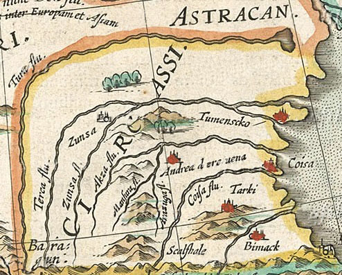
When it comes to the Circassia, I feel as though we have another Moldavia situation on our hands. While the incredibly mythologised Inal the Great did most likely unify parts of Circassia in his lifetime, some 100 years after the start date, we can ascertain that there was virtually no unity between the chiefdoms before that.

I feel as though it'd be anachronistic, and in general, inaccurate, to portray Circassia as a united, feudal tag, with low control in all locations but the capital, as it is shown currently. On the other hand, making 5 or so geographical-toponym based OPM tribal chiefdoms with the same culture and religion would probably be more accurate. Same goes with Alania-Ossetia, as they had already begun to disintegrate into tribalism, as evidenced by their attacks and raids on Georgia before the start date.

The paper posted by @heavyblood presents a rather weak case for an overlord chief-prince. While we know that virtually all north Caucasian tribes swore fealty to the Georgian king, I question the latter's ability to exert high influence in the northwestern Caucasus of all places.

I doubt there are any Circassians on the forum who can help us in this regard...

1572_Europa_Ortelius.H.jpg
 
  • 5Like
  • 2
  • 1
Reactions:
Economy of Georgia
Part 2
This is the second part of my feedback regarding Georgia's economy in 1337. The first part can be seen here.

In this post I would like to discuss Raw Materials, arguably one of the most important aspects of a region in such a game. I will try to avoid using the in-game locations and provinces as a metric, as they're subject to change, and instead, I will analyse each region individually and give a general feedback for maximum clarity.

Up front, I will post a few maps from authoritative sources, namely the National Atlas of Georgia, from which I will draw several assertions from:


National Atlas of Georgia 2.png
National Atlas of Georgia.png
National Atlas of Georgia 3-1.png
National Atlas of Georgia 3-2.png


Abkhazia

Abkhazia.jpg


Abkhazia is a region whose economy historically depended massively on the Black Sea. Trade with other states was facilitated by a long coastline and great natural harbours, making for very viable export economy.

One of the most significant of the Greek Black Sea colonies, Dioscurias, was located in the middle-southern parts of Abkhazia.

While in antiquity a large part of the exports were slaves, especially from the Pontic Steppe, the practice had long disappeared by the 14th century, though it would unfortunately resurface in the 16th century, once the Black Sea became the "Turkish lake".

Sources such as Polybius mention the existence of apiculture, cattle-breeding, and fishing in the region as well.

I will also quickly mention that the subtropical climate of Abkhazia was perfect for growing citruses and tea, as we will see in the next entries.

In-game, as I have written previously, much of the coastline should be leased to a Building Based Country known as the Consulate of Sebastopolis/Savastopoli, a vassal of the Genoese Gazaria in Crimea.


Map.png

(Credit to @Reavici on Reddit).


In summary, I wouldn't alter the raw goods of the region too much from their current iteration, but if the region needs an artificial buff, the devs could in theory reasonably add high-value goods, such as honey, to the province.

I think it would also be prudent to make the location of Tskhumi produce slaves, if an Islamic country (most likely the Ottomans) controls it, to represent the Caucasian-Islamic slave trade.


Odishi
Odishi.jpg


Also known as Colchis, Lazica, Egrisi, or Samegrelo, this region has been known as the heart of major trade kingdoms throughout recorded history.

Like Abkhazia, it was home to major Greek colonies, like Phasis, which is contemporary Poti.

It was known as the easternmost point of the Black Sea: "to Phasis where ships end their course".

As with most of lowland western Georgia, Mingrelia was very dependant upon Kartlian and Kakhetian grain to sustain its population during the period of unity, as the region wasn't suited to traditional wheat cultivation, which was very commonplace in the middle ages.

The region was nonetheless rich in other resources. According to Strabo:

"The country (Colchis) is fertile and its produce is good, except the honey, which has generally a bitter taste. It furnishes all materials for ship-building. It produces them in great plenty, and they are conveyed down by its rivers. It supplies flax, hemp, wax, and pitch, in great abundance. Its linen manufacture is celebrated, for it was exported to foreign parts".

Like all parts of Georgia, obviously excluding the western and eastern highland regions, viticulture is quite developed in Mingrelia, though not as much as Kakheti, which we will get to later.

In summary, I'd suggest making the regional goods even more naval-centric, especially on the coasts. If needed, Sturdy Grains can also be added to any of the locations in the province, to represent the local reliance upon Ghomi instead of grain.


Guria
Guria.jpg


Guria (and contemporaneously Adjara) represent the southernmost parts of western Georgia, bordering Lazeti and Tao-Klarjeti, in historical southern Georgia.

Guria, like the previous two provinces, is a coastal region, primarily focused on trade. Adjara, that is, historical Adjara, was an inland province, and was much more insular than the former.

Historically, Guria was an important trade center, connecting the Asian flow of goods with Greece and the wider Mediterranean world. According to Nika Khoperia:

"After the fracture of the Roman Empire, the Eastern Roman Empire (Byzantium) remained in control of the Black Sea region and continued to actively trade with the kingdom of Lazica that had been formed in western Georgia. The VI century historian Procopius of Caesarea highlighted the importance of the salt trade to the Laz. In 535, the Byzantines built the fortified city of Petra in Lazica and used it to start monopolizing the economy. All commercial goods, including salt, would arrive in Petra, where the Greeks would purchase them and resell them to the Laz at a substantially higher price. This policy led to a conflict between Byzantium and Lazica, with the latter temporarily allying themselves with the Sasanian Empire."

Thus, a fish RGO in the location of Batumi would be highly fitting, instead of the very inaccurate wheat.

Concerning the rest of the region, I think it would be very interesting if the locations were to be dynamically changed to tea by the 18th century.

As is well known in the former Soviet sphere, Georgia was the only constituent Republic where tea could be grown, and due to the semi-autarkic nature of the state, became nearly the only source for it in a market with huge demand.

It isn't known when exactly tea was first introduced to the region, so perhaps a little leeway can be given in the name of variety.

To summarise, some fixes and changes to this region would be highly appreciated.


Lazeti

Lazeti.jpg
%E1%83%AD%E1%83%90%E1%83%9C%E1%83%94%E1%83%97%E1%83%98_%E1%83%90%E1%83%A6%E1%83%9B%E1%83%9D%E1%83%A1%E1%83%90%E1%83%95%E1%83%9A%E1%83%94%E1%83%97_%E1%83%9A%E1%83%90%E1%83%96%E1%83%94%E1%83%97%E1%83%98_Lazeti_Do%C4%9Fu_Lazistan_%D0%9B%D0%B0%D0%B7%D0%B5%D1%82%D0%B8_%D0%9B%D0%B0%D0%B7%D0%B8%D1%81%D1%82%D0%B0%D0%BD.png


Lazeti, also known as Chaneti, Lazona or Lazistan, is one of the Kartvelian provinces along the Black Sea coast. While often under the thumb of foreign empires, the Laz people maintained their autonomy due to their geographical isolation.

Again, using Procopius as a source leads to some quite interesting observations:

"And apart from this, salt is produced nowhere in Lazica, nor indeed does grain grow there nor the vine nor any other good thing. But from the Romans along the coast everything is brought in to them by ship, and even so they do not pay gold to the traders, but hides and slaves and whatever else happens to be found there in great abundance"

Among the Laz, animal husbandry is widespread even today in eastern Pontus, so some fish, fur, and lumber locations would likely be most appropriate.

I've attached an image of classical Lazica to help you model the province with greater ease (though I'd recommend keeping the land north of the Chorokh as a part of Batumi, 3-4 locations would probably suffice for the province).


Imereti

Imereti.jpg


Imereti is one of the core provinces of Georgia, connecting the east with the west.

It is very rich in resources, namely in metals like Manganese, which made up 50% of the world's supply during the 20th century.

It is very likely that the Ferromanganese alloys were the reason proto-Georgian metalmaking was so well-known even in antiquity.

Sources such as Strabo report that the Iberians and Chalybes were renowned for their metallurgy.

The only real complaint I have with regards to the province is that the wheat isn't very accurate to the location of Kutaisi. As I've said before, land in western Georgia isn't suited at all with wheat farming.

Prince Vakhushti reports that the "people of western Georgia eat ghomi plentifully" and also that "the little that is grown (wheat) is very fine-grained."

While his accounts are from the early-mid 18th century, the fact of the matter is that this situation has remained unchanged since antiquity.

Western Georgia was utterly reliant upon Kartlian and Kakhetian exports to sustain their population, and I hope this inner power struggle between the fractured rump states can be represented in-game.


Svaneti

Svaneti-Lechkhumi.jpg


Svaneti, Lechkhumi, and in general, the western Georgian uplands are some of the least densely populated parts of Georgia, due to their unsuitable terrain for large-scale inhabitation. The region is nevertheless quite rich in resources.

In antiquity, the myth of the Colchian Golden Fleece was known throughout the Hellenistic world, and scholars believe that the local practise of collecting gold with sheep-skin from the many rivers of the highland region is indeed the source of the myth.

While perhaps a little bit overpowered, I think it would be fun if a random event gave the owner of the province a gold producing location until the end of the game.

Gems and silver are also a possibility, especially in the isolated areas farther north.

Otherwise, the region is very well represented. I especially like the depiction of the location of Tsageri, as Racha-Lechkhumian wines are arguably some of the highest-quality wines in Georgia.

According to the National Atlas of Georgia, the region is indeed very mineral-rich, so the depiction of lead in the location of Tsesi is most likely accurate. I would recommend changing the lumber-producing Lentekhi to iron (in place of Gori, which we will get to soon).


Inner Kartli

Kartli.jpg


Kartli — one of the core provinces of Georgia. The toponym from which the native name of Georgia emeges in the 5th century.

While not rich in metals or lumber, the region is very agriculturally productive, only second to Kakheti. Naturally, the province was also host to the former capital of the kingdom, in Mstkheta.

Ancient authors take note of Iberia's agricultural output and lifestyle, especially when compared to their immediate neighbours near the Caucasus:

"The Soanes (modern Svans) use remarkable poisons for the points of their missiles; and even people who are not wounded by the poisoned missiles suffer from their odor. Now in general the tribes in the neighborhood of the Caucasus occupy barren and cramped territories, but the tribes of the Albanians and the Iberians, which occupy nearly all the isthmus above-mentioned, might also be called Caucasian tribes; and they possess territory that is fertile and capable of affording an exceedingly good livelihood."

Therefore, I'd suggest adding a lot of wheat, wine livestock, and fruit to the province.

Inner Kartli has also been the home of Georgian apiculture in the east, so beeswax can also be considered as a reasonable addition to the province.


Samtskhe

Samtskhe.jpg


Meskheti, also known as Samtskhe, used to be an important marchland of Georgia, often being the first line of defence against an invading force from the south. The region was known for being quite militarised.

Most of the province is quite cold and unsuitable for agriculture on a large scale, except for the traditional capital of Akhaktsikhe, which lies on the fertile Mtkvari river basin.

According to Apolon Tabuashvili in "Prices in Feudal Georgia (10th-18th centuries)":

(translation by me)

"To get an idea of the annual harvest of wheat and, in general, grain crops in Georgia during the feudal era, the data contained in the Great Register of the Gurjistan Province of 1595, which was compiled by M. Svanidze, are very interesting. According to the author's calculations, at the end of the 16th century, 12,633 households living in 711 villages described in the book annually produced 36,182,715 kg. of wheat."

Again, in spite of the slight anachronism, this account is still of value to us.

Thus, I suggest adding livestock, stone, and a wheat tile (in the capital) to the province, to simulate its relatively sparse topography and barren nature.


Tao-Klarjeti

Tao-Klarjeti.jpg


Tao-Klarjeti is a formerly Georgian region, which is very rich in resources.

In mediaeval Georgia, Tao-Klarjeti was known as the "უდაბნო", or "desert". It was, therefore, a very active hub of Cappadocian-inspired monasticism, popularised by Basil the Great.

The rocks and marbles of this province allowed people like Gregory of Khandzta to create numerous churches in and around the region.

One example of an expensive resource of the province is Oltu Stone. In light of this, I suggest adding gems to the location.

Otherwise, as the old nickname suggests, it's quite a barren land, unsuited to large-scale agriculture beyond small farms near the riverbeds.


Lower Kartli

Kvemo Kartli.jpg


Kvemo Kartli, anglicised as Lower Kartli, is at the heart of Georgia, and has been so for nearly 1000 years.

It was arguably the most economically significant part of the country, and many of the extremely ancient cities of Georgia, like Dmanisi, can be found here.

The primary reason for the importance of the region was due to oriental trade. As the region laid at the centre of the Armeno-Shirvanese trade routes, the major cities of the region benefited greatly from trade tolls (much like today, I'd argue).


11-12th century trade routes.jpg
Roads of Georgia in the Middle Ages.png


According to "Georgia and Silk Roads (VI-XIII cc.)", we have a source from Ibn Isfandiyar regarding the silk produced in Tbilisi in the late 13th century:
(translation by me)

"It seems that silk production in Tbilisi was highly developed. Almost all oriental sources mention silk in their lists of products exported from Tbilisi. A particularly interesting account is preserved by Ibn Isfandiyar, when the ruler of Tabaristan, Ardashir ibn Hasan, sent Byzantine, Baghdadian and Tbilisian fabrics in bundles along with other gifts to Khwarazmshah Ala al-Din Tekish. Most likely, the fabrics taken from Tbilisi were supposed to be "silk". The mention of Tbilisian silk alongside Baghdadian and Greek ones should undoubtedly indicate its high quality."

I would argue that a silk RGO in Tbilisi would be appropriate for this reason.

Other locations in this province should also likely have higher-value goods associated with trade, like salt, dyes, cloth, etc. The lower Mtkvari river basin is also quite agriculturally significant, so some wheat locations wouldn't be bad as well.

The current distribution of goods admittedly leaves a lot to be desired.


Mtianeti

Mtianeti.jpg


The eastern part of the Georgian Caucasus goes by many, many different names, so I decided to suggest naming the province Mtianeti (literally mountain-land), as it is the most neutral and most widely applicable to the region.

As the region with the lowest population density in Georgia, I have trouble with recommending resources for the province beyond the typical lumber, stone, wool, and wild game.

Let us move on to the final province I'm going to examine today...


Kakheti
Kakheti.jpg


Kakheti, (which subsumed the neighbouring historical region of Hereti over time), used to, and continues to be, one of the most important parts of Georgia, due to its enormous output of wheat, wine, and other goods.

As I've said already, ancient authors considered the Caucasian lowlands to be very fertile. This continued to be true in the middle ages, though the many Turkmen invasions of the region did unfortunately see mass-level depopulation.

I'd highly recommend changing most of the locations to produce exactly that, instead of the livestocks, lumber, lead, and so on.

It is difficult to overstate the significance of wine to Georgian culture. In all but the highland provinces I mentioned, wine is cultivated and produced on a local basis — Especially in Kakheti.

The southern part of Kakheti, historically known as Cambysene, was not suited to agriculture like the Alazani valley. It was used by pastoralists (often Turkmen) as a winter pasture for this reason. Thus, putting livestock or wool in these locations would be best.


That is all I have to suggest. If you have any questions or comments, write to me.

Note that I didn't mention farmlands once, as I personally disagree with its existence in a game as detailed as this. However, if needed, I'd recommend giving several locations in both inner and lower Kartli, and in parts of Kakheti this special terrain type.


Sources used:

 
Last edited:
  • 11
  • 5Love
  • 1Like
Reactions:
Economy of Georgia
Part 2
This is the second part of my feedback regarding Georgia's economy in 1337. The first part can be seen here.

In this post I would like to discuss Raw Materials, arguably one of the most important aspects of a region in such a game. I will try to avoid using the in-game locations and provinces as a metric, as they're subject to change, and instead, I will analyse each region individually and give a general feedback for maximum clarity.

Up front, I will post a few maps from authoritative sources, namely the National Atlas of Georgia, from which I will draw several assertions from:


Abkhazia is a region whose economy historically depended massively on the Black Sea. Trade with other states was facilitated by a long coastline and great natural harbours, making for very viable export economy.

One of the most significant of the Greek Black Sea colonies, Dioscurias, was located in the middle-southern parts of Abkhazia.

While in antiquity a large part of the exports were slaves, especially from the Pontic Steppe, the practice had long disappeared by the 14th century, though it would unfortunately resurface in the 16th century, once the Black Sea became the "Turkish lake".

Sources such as Polybius mention the existence of apiculture, cattle-breeding, and fishing in the region as well.

I will also quickly mention that the subtropical climate of Abkhazia was perfect for growing citruses and tea, as we will see in the next entries.

In-game, as I have written previously, much of the coastline should be leased to a Building Based Country known as the Consulate of Sebastopolis/Savastopoli, a vassal of the Genoese Gazaria in Crimea.


View attachment 1254715
(Credit to @Reavici on Reddit).


In summary, I wouldn't alter the raw goods of the region too much from their current iteration, but if the region needs an artificial buff, the devs could in theory reasonably add high-value goods, such as honey, to the province.

I think it would also be prudent to make the location of Tskhumi produce slaves, if an Islamic country (most likely the Ottomans) controls it, to represent the Caucasian-Islamic slave trade.


Odishi
View attachment 1254688


Also known as Colchis, Lazica, Egrisi, or Samegrelo, this region has been known as the heart of major trade kingdoms throughout recorded history.

Like Abkhazia, it was home to major Greek colonies, like Phasis, which is contemporary Poti.

It was known as the easternmost point of the Black Sea: "to Phasis where ships end their course".

As with most of lowland western Georgia, Mingrelia was very dependant upon Kartlian and Kakhetian grain to sustain its population during the period of unity, as the region wasn't suited to traditional wheat cultivation, which was very commonplace in the middle ages.

The region was nonetheless rich in other resources. According to Strabo:

"The country (Colchis) is fertile and its produce is good, except the honey, which has generally a bitter taste. It furnishes all materials for ship-building. It produces them in great plenty, and they are conveyed down by its rivers. It supplies flax, hemp, wax, and pitch, in great abundance. Its linen manufacture is celebrated, for it was exported to foreign parts".

Like all parts of Georgia, obviously excluding the western and eastern highland regions, viticulture is quite developed in Mingrelia, though not as much as Kakheti, which we will get to later.

In summary, I'd suggest making the regional goods even more naval-centric, especially on the coasts. If needed, Sturdy Grains can also be added to any of the locations in the province, to represent the local reliance upon Ghomi instead of grain.


Guria
View attachment 1254736


Guria (and contemporaneously Adjara) represent the southernmost parts of western Georgia, bordering Lazeti and Tao-Klarjeti, in historical southern Georgia.

Guria, like the previous two provinces, is a coastal region, primarily focused on trade. Adjara, that is, historical Adjara, was an inland province, and was much more insular than the former.

Historically, Guria was an important trade center, connecting the Asian flow of goods with Greece and the wider Mediterranean world. According to Nika Khoperia:

"After the fracture of the Roman Empire, the Eastern Roman Empire (Byzantium) remained in control of the Black Sea region and continued to actively trade with the kingdom of Lazica that had been formed in western Georgia. The VI century historian Procopius of Caesarea highlighted the importance of the salt trade to the Laz. In 535, the Byzantines built the fortified city of Petra in Lazica and used it to start monopolizing the economy. All commercial goods, including salt, would arrive in Petra, where the Greeks would purchase them and resell them to the Laz at a substantially higher price. This policy led to a conflict between Byzantium and Lazica, with the latter temporarily allying themselves with the Sasanian Empire."

Thus, a fish RGO in the location of Batumi would be highly fitting, instead of the very inaccurate wheat.

Concerning the rest of the region, I think it would be very interesting if the locations were to be dynamically changed to tea by the 18th century.

As is well known in the former Soviet sphere, Georgia was the only constituent Republic where tea could be grown, and due to the semi-autarkic nature of the state, became nearly the only source for it in a market with huge demand.

It isn't known when exactly tea was first introduced to the region, so perhaps a little leeway can be given in the name of variety.

To summarise, some fixes and changes to this region would be highly appreciated.


Lazeti, also known as Chaneti, Lazona or Lazistan, is one of the Kartvelian provinces along the Black Sea coast. While often under the thumb of foreign empires, the Laz people maintained their autonomy due to their geographical isolation.

Again, using Procopius as a source leads to some quite interesting observations:

"And apart from this, salt is produced nowhere in Lazica, nor indeed does grain grow there nor the vine nor any other good thing. But from the Romans along the coast everything is brought in to them by ship, and even so they do not pay gold to the traders, but hides and slaves and whatever else happens to be found there in great abundance"

Among the Laz, animal husbandry is widespread even today in eastern Pontus, so some fish, fur, and lumber locations would likely be most appropriate.

I've attached an image of classical Lazica to help you model the province with greater ease (though I'd recommend keeping the land north of the Chorokh as a part of Batumi, 3-4 locations would probably suffice for the province).


Imereti is one of the core provinces of Georgia, connecting the east with the west.

It is very rich in resources, namely in metals like Manganese, which made up 50% of the world's supply during the 20th century.

It is very likely that the Ferromanganese alloys were the reason proto-Georgian metalmaking was so well-known even in antiquity.

Sources such as Strabo report that the Iberians and Chalybes were renowned for their metallurgy.

The only real complaint I have with regards to the province is that the wheat isn't very accurate to the location of Kutaisi. As I've said before, land in western Georgia isn't suited at all with wheat farming.

Prince Vakhushti reports that the "people of western Georgia eat ghomi plentifully" and also that "the little that is grown (wheat) is very fine-grained."

While his accounts are from the early-mid 18th century, the fact of the matter is that this situation has remained unchanged since antiquity.

Western Georgia was utterly reliant upon Kartlian and Kakhetian exports to sustain their population, and I hope this inner power struggle between the fractured rump states can be represented in-game.


Svaneti, Lechkhumi, and in general, the western Georgian uplands are some of the least densely populated parts of Georgia, due to their unsuitable terrain for large-scale inhabitation. The region is nevertheless quite rich in resources.

In antiquity, the myth of the Colchian Golden Fleece was known throughout the Hellenistic world, and scholars believe that the local practise of collecting gold with sheep-skin from the many rivers of the highland region is indeed the source of the myth.

While perhaps a little bit overpowered, I think it would be fun if a random event gave the owner of the province a gold producing location until the end of the game.

Gems and silver are also a possibility, especially in the isolated areas farther north.

Otherwise, the region is very well represented. I especially like the depiction of the location of Tsageri, as Racha-Lechkhumian wines are arguably some of the highest-quality wines in Georgia.

According to the National Atlas of Georgia, the region is indeed very mineral-rich, so the depiction of lead in the location of Tsesi is most likely accurate. I would recommend changing the lumber-producing Lentekhi to iron (in place of Gori, which we will get to soon).


Inner Kartli

View attachment 1255465

Kartli — one of the core provinces of Georgia. The toponym from which the native name of Georgia emeges in the 5th century.

While not rich in metals or lumber, the region is very agriculturally productive, only second to Kakheti. Naturally, the province was also host to the former capital of the kingdom, in Mstkheta.

Ancient authors take note of Iberia's agricultural output and lifestyle, especially when compared to their immediate neighbours near the Caucasus:

"The Soanes (modern Svans) use remarkable poisons for the points of their missiles; and even people who are not wounded by the poisoned missiles suffer from their odor. Now in general the tribes in the neighborhood of the Caucasus occupy barren and cramped territories, but the tribes of the Albanians and the Iberians, which occupy nearly all the isthmus above-mentioned, might also be called Caucasian tribes; and they possess territory that is fertile and capable of affording an exceedingly good livelihood."

Therefore, I'd suggest adding a lot of wheat, wine livestock, and fruit to the province.

Inner Kartli has also been the home of Georgian apiculture in the east, so beeswax can also be considered as a reasonable addition to the province.


Meskheti, also known as Samtskhe, used to be an important marchland of Georgia, often being the first line of defence against an invading force from the south. The region was known for being quite militarised.

Most of the province is quite cold and unsuitable for agriculture on a large scale, except for the traditional capital of Akhaktsikhe, which lies on the fertile Mtkvari river basin.

According to Apolon Tabuashvili in "Prices in Feudal Georgia (10th-18th centuries)":

(translation by me)

"To get an idea of the annual harvest of wheat and, in general, grain crops in Georgia during the feudal era, the data contained in the Great Register of the Gurjistan Province of 1595, which was compiled by M. Svanidze, are very interesting. According to the author's calculations, at the end of the 16th century, 12,633 households living in 711 villages described in the book annually produced 36,182,715 kg. of wheat."

Again, in spite of the slight anachronism, this account is still of value to us.

Thus, I suggest adding livestock, stone, and a wheat tile (in the capital) to the province, to simulate its relatively sparse topography and barren nature.


Tao-Klarjeti

View attachment 1255585


Tao-Klarjeti is a formerly Georgian region, which is very rich in resources.

In mediaeval Georgia, Tao-Klarjeti was known as the "უდაბნო", or "desert". It was, therefore, a very active hub of Cappadocian-inspired monasticism, popularised by Basil the Great.

The rocks and marbles of this province allowed people like Gregory of Khandzta to create numerous churches in and around the region.

One example of an expensive resource of the province is Oltu Stone. In light of this, I suggest adding gems to the location.

Otherwise, as the old nickname suggests, it's quite a barren land, unsuited to large-scale agriculture beyond small farms near the riverbeds.


Lower Kartli

View attachment 1255480


Kvemo Kartli, anglicised as Lower Kartli, is at the heart of Georgia, and has been so for nearly 1000 years.

It was arguably the most economically significant part of the country, and many of the extremely ancient cities of Georgia, like Dmanisi, can be found here.

The primary reason for the importance of the region was due to oriental trade. As the region laid at the centre of the Armeno-Shirvanese trade routes, the major cities of the region benefited greatly from trade tolls (much like today, I'd argue).


View attachment 1255485View attachment 1255543


According to "Georgia and Silk Roads (VI-XIII cc.)", we have a source from Ibn Isfandiyar regarding the silk produced in Tbilisi in the late 13th century:
(translation by me)

"It seems that silk production in Tbilisi was highly developed. Almost all oriental sources mention silk in their lists of products exported from Tbilisi. A particularly interesting account is preserved by Ibn Isfandiyar, when the ruler of Tabaristan, Ardashir ibn Hasan, sent Byzantine, Baghdadian and Tbilisian fabrics in bundles along with other gifts to Khwarazmshah Ala al-Din Tekish. Most likely, the fabrics taken from Tbilisi were supposed to be "silk". The mention of Tbilisian silk alongside Baghdadian and Greek ones should undoubtedly indicate its high quality."

I would argue that a silk RGO in Tbilisi would be appropriate for this reason.

Other locations in this province should also likely have higher-value goods associated with trade, like salt, dyes, cloth, etc. The lower Mtkvari river basin is also quite agriculturally significant, so some wheat locations wouldn't be bad as well.

The current distribution of goods admittedly leaves a lot to be desired.


The eastern part of the Georgian Caucasus goes by many, many different names, so I decided to suggest naming the province Mtianeti (literally mountain-land), as it is the most neutral and most widely applicable to the region.

As the region with the lowest population density in Georgia, I have trouble with recommending resources for the province beyond the typical lumber, stone, wool, and wild game.

Let us move on to the final province I'm going to examine today...


Kakheti
View attachment 1255564


Kakheti, (which subsumed the neighbouring historical region of Hereti over time), used to, and continues to be, one of the most important parts of Georgia, due to its enormous output of wheat, wine, and other goods.

As I've said already, ancient authors considered the Caucasian lowlands to be very fertile. This continued to be true in the middle ages, though the many Turkmen invasions of the region did unfortunately see mass-level depopulation.

I'd highly recommend changing most of the locations to produce exactly that, instead of the livestocks, lumber, lead, and so on.

It is difficult to overstate the significance of wine to Georgian culture. In all but the highland provinces I mentioned, wine is cultivated and produced on a local basis — Especially in Kakheti.

The southern part of Kakheti, historically known as Cambysene, was not suited to agriculture like the Alazani valley. It was used by pastoralists (often Turkmen) as a winter pasture for this reason. Thus, putting livestock or wool in these locations would be best.


That is all I have to suggest. If you have any questions or comments, write to me.

Note that I didn't mention farmlands once, as I personally disagree with its existence in a game as detailed as this. However, if needed, I'd recommend giving several locations in both inner and lower Kartli, and in parts of Kakheti this special terrain type.


Sources used:

bro ur giving Paradox developers so much job lol
 
  • 6Haha
Reactions:


Here are some of the compiled countries, with their titles, types, rulers, dynasties, their rulers' cultures and religions. Many of them are empty due to lack of information, and some I've filled with guesswork.

NOTE: Cultures & Religions are those of the RULER, not necessarily the population

NOTE: Vassal relations are represented by indentations.


Maps for reference:
View attachment 1251633 View attachment 1251216


Regarding the faith of Ahmad al Rumaythi, I think he should be Zaydi Shia, as per this excerpt from the wiki:
1740492245788.png

Note that the conversion to Sunni Islam did not begin until the second half of the 14th century, whereas Ahmad was already the Sharif of Al Hilla by the 1330s, and would have been raised as a Zayidi muslim before leaving Mecca.
 
  • 2
  • 1Like
Reactions:
Oo yeah, Persia and Caucasus feedback next?? :oops:

The whole are has been changed a lot, @SuperLexxe's map for reference:
I still have so much to write ;_; (flavour, diplomacy, army sprites).

Don't release the feedback yet, O Paradox! Work on Britain, or something.

As of now, the map looks unfinished. I won't get my hopes high, though - the level of detail present in our maps may not necessarily translate to the finished product.
 
Last edited:
  • 4Haha
Reactions:
Yeah, looks like there's a couple of things that need adjusting. Hillah's too big, and the various Banu Tayy groups are split into two disconnected chunks. Perhaps some of those crossings or whatever-they-were-called were added as well?
 
Last edited:
  • 2Like
  • 1
Reactions:
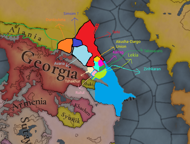
Proposal for changes in Dagestan

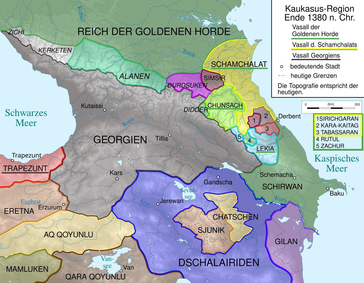
The Lezgin tribes in 1337 should have been more dependent on Shirvan.


Zrzut ekranu 2025-02-26 180031.png
Zrzut ekranu 2025-02-26 180235.png


Akhty,Kurakh,Rutul
This road was used by Dagestani tribes to attack the kingdom of Georgia.
Zrzut ekranu 2025-02-26 181031.png

Kumyk Principalities
The capitals of these principalities should appear on the map as locations.

1:Utamysh
2:Ullubiyaul/Boynak
3:Mehtuli Capital:Dorgeli
4:Tarki
5:Endirey
6:Aksay
7:Braguny
8:Tyumen
The city of Kayakent was captured by Kaitag sometime in the 18th century, giving the country access to Lake Caspian.

Principalities of the Dargin people

Akusha-Dargo​

Kaba Dargo​

Muira Capital:Kalkni

Kaitag Capital:

Zirihgeran​

.........................................................................................................................................................................................................................................................

Tabasaran​

Tsakhur
Location 2.png

Political map of the Caucasus in 1337
Colored Wastelands.png
 
Last edited:
  • 2
  • 2
  • 1Like
Reactions:
I've been wondering whether the map made by @SuperLexxe and us is in line with Paradox's philosophy of game design. An offhand remark by @SaintDaveUK in the latest Tinto Talks regarding the statehood of Welsh marches made me consider this issue for this region:

"So in the end you decided with having Duhram being a normal tag @ SaintDaveUK ?"

"Nothing definitive. Currently I'm not convinced by how Wales and the Palatinates feel to play so they are WIP. I think Ireland is close to being finished though."

Perhaps we should reconsider the existence and playability of very minor polities in our proposals. Let's take the Duchy of Tao, for example. A 2-location-minor under Georgia — does it deserve to be playable?

bleh.png


Going by St. Dave's comment, we must examine the context of the British Isles. The very existence of a polity in Wales is contingent upon how fun it is to play. Wales' unclear legal position as a part of England in 1337 allows for this kind of leeway.

Considering this, I would argue that countries such as of Tao and Tsakhuri (and many of the Kurdish statelets researched and proposed by @Ispil) don't really have any justification to exist. Instead, can't they be abstracted with a nobility/tribal estates in their respective locations?

Just to make it clear, I'm not arguing that all of the OPMs and similarly sized countries should be directly integrated with their overlords/neighbours, I'm simply evaluating St. Dave's comment and applying it to our feedback. While I am, by all means, all for granularity (especially due to the earlier start date of 1337 compared to 1444, more locations/pixels, etc.), I feel as though we have to approach our own feedback with some level of scrutiny not only for historicity, but for gameplay enjoyability of the country in question.

I'd love to hear the devs' thoughts, if possible.
 
  • 4Like
  • 1
Reactions:
I do sometimes think of this when it comes to Tusi states in china, that a lot of people want to see. At the end of the day, what point will their existence provide? I worry they will at best be ahistorical and end up with a little mini HRE under Chinese auspices with them constantly fighting each other, or at worst just be boring. Since that's basically what they did, they just sort of... existed, through the period. For those Kurdish states, I'd wonder if they wouldn't be better as just tribal pops under the Jalayirids or something. But at the same time I do think they are definitely a large enough grouping in the area that they'd be fine to have, like they look like they could have their own inter kurdish politics as well as interactions with the outside forces in their own way. IMO that could justify them being a thing.

For Tao, IMO with things like that even if they don't have much chance of striking out they are fine to exist. There are plenty of OPM's in the HRE, no reason they can't exist even if they basically exist to be conquered/unified. I think its fine.
 
  • 3
  • 1
Reactions:
I've been wondering whether the map made by @SuperLexxe and us is in line with Paradox's philosophy of game design. An offhand remark by @SaintDaveUK in the latest Tinto Talks regarding the statehood of Welsh marches made me consider this issue for this region:

"So in the end you decided with having Duhram being a normal tag @ SaintDaveUK ?"


Perhaps we should reconsider the existence and playability of very minor polities in our proposals. Let's take the Duchy of Tao, for example. A 2-location-minor under Georgia — does it deserve to be playable?

View attachment 1259896

Going by St. Dave's comment, we must examine the context of the British Isles. The very existence of a polity in Wales is contingent upon how fun it is to play. Wales' unclear legal position as a part of England in 1337 allows for this kind of leeway.

Considering this, I would argue that countries such as of Tao and Tsakhuri (and many of the Kurdish statelets researched and proposed by @Ispil) don't really have any justification to exist. Instead, can't they be abstracted with a nobility/tribal estates in their respective locations?

Just to make it clear, I'm not arguing that all of the OPMs and similarly sized countries should be directly integrated with their overlords/neighbours, I'm simply evaluating St. Dave's comment and applying it to our feedback. While I am, by all means, all for granularity (especially due to the earlier start date of 1337 compared to 1444, more locations/pixels, etc.), I feel as though we have to approach our own feedback with some level of scrutiny not only for historicity, but for gameplay enjoyability of the country in question.

I'd love to hear the devs' thoughts, if possible.
I think part of the thing being brought up by the devs here is a matter of whether or not those countries are interacting with the main country in a way that makes sense. Like, does representing the Palatinate of Durham as a vassal country actually align with how it should be working? Does its interactions with England feel fun and interesting, or is it just a kinda "sit around and do nothing for 500 years" sorta game where it begs the question of whether it's even correctly representing what it's meant to represent. I definitely understand the debate, and I too am not entirely convinced that representing it as a vassal country makes sense. To my knowledge it never raised an army against anyone, for instance.

As for those various Kurdish tribes, there's two reasons for them to stick around. One, there's plenty of conflict between them; there's a game to be played in Kurdistan. Two, they're relevant also for the states that develop on either side of the region, such as the Safavids and the Ottomans (historically) as composing a border region complete with both powers intervening in the various Kurdish struggles in an attempt to establish hegemony. Those Kurdish tribes can also subsequently use that to their advantage, playing their benefactors against each other to acquire more and more land from the other tribes. They're all "subjects" of the Jalayirids in the current proposed setup insomuch that they're aligned with Jalayirid interests (or at least aren't opposing them), but they aren't really subjects in the sense that their armies are going to come join the Jalayirids in their wars. Rather, they're willing to exist within the Jalayirid state as long as said state is doing the bare minimum to impose anything on them. Such allegiance is, to say the least, fickle and brittle; if the Jalayirids actually tried to, say, tax the Kurdish population, those "subjects" would stop being subjects real quick.

Representing them with tribes also wouldn't work, because there was plenty of conflict between them as well. To say nothing of previous Kurdish states that formed in the region prior to the Mongols; depending on the contours of history, another Kurdish state could arise in the area. Taking all of that and bottling it up as "tribal pops" is missing the exact extent of their autonomy, sovereignty, and conflicts.

Like, I do fully agree with you (just look at my argument in the Steppe thread) that not every single plausible "this person had power in this area" needs to be represented because in many ways they're just a part of the state and only have meaning in the event that the state itself ceased to exist. Powerful nobles, even with title, are not necessarily best represented as vassal subjects. It's when they're treated as states in their own right that they get such status. My understanding of Georgia at this time is that those various vassals that are proposed were in many ways treated as states of their own and not just "nobles with some land in the area". This in contrast with Jovan Oliver in Serbia; a very powerful noble with much land and in many ways an effective claim to self-sovereignty, but was still heavily enmeshed within the Kingdom of Serbia to the point where representing him as a vassal subject would be doing him a great disservice.
 
  • 5
  • 2Like
  • 1
Reactions:
I've been wondering whether the map made by @SuperLexxe and us is in line with Paradox's philosophy of game design. An offhand remark by @SaintDaveUK in the latest Tinto Talks regarding the statehood of Welsh marches made me consider this issue for this region:

"So in the end you decided with having Duhram being a normal tag @ SaintDaveUK ?"


Perhaps we should reconsider the existence and playability of very minor polities in our proposals. Let's take the Duchy of Tao, for example. A 2-location-minor under Georgia — does it deserve to be playable?

View attachment 1259896

Going by St. Dave's comment, we must examine the context of the British Isles. The very existence of a polity in Wales is contingent upon how fun it is to play. Wales' unclear legal position as a part of England in 1337 allows for this kind of leeway.

Considering this, I would argue that countries such as of Tao and Tsakhuri (and many of the Kurdish statelets researched and proposed by @Ispil) don't really have any justification to exist. Instead, can't they be abstracted with a nobility/tribal estates in their respective locations?

Just to make it clear, I'm not arguing that all of the OPMs and similarly sized countries should be directly integrated with their overlords/neighbours, I'm simply evaluating St. Dave's comment and applying it to our feedback. While I am, by all means, all for granularity (especially due to the earlier start date of 1337 compared to 1444, more locations/pixels, etc.), I feel as though we have to approach our own feedback with some level of scrutiny not only for historicity, but for gameplay enjoyability of the country in question.

I'd love to hear the devs' thoughts, if possible.

I feel like a lot of our proposals are more just pointing out things which existed historically (or at least they should be), not necessarily what we think the final product should be, since we don't have access to the game there's not really a way for us to test how it "feels" even if we got a mini guide for what will or won't be considered a state in gameplay terms. The answer will always be "it's complicated" because the game is an abstraction no matter what, and it's way easier to remove a suggestion compared to one of the devs noticing a "borderline" vassal then having to do the research from scratch just to come to the same conclusion about not including a subject state.

I think a lot of people have been doing this anyway, but it's good to include information about the practical, historical examples of the proposed subject state's independence.
 
  • 2
  • 1
Reactions:
I do sometimes think of this when it comes to Tusi states in china, that a lot of people want to see. At the end of the day, what point will their existence provide? I worry they will at best be ahistorical and end up with a little mini HRE under Chinese auspices with them constantly fighting each other, or at worst just be boring. Since that's basically what they did, they just sort of... existed, through the period. For those Kurdish states, I'd wonder if they wouldn't be better as just tribal pops under the Jalayirids or something. But at the same time I do think they are definitely a large enough grouping in the area that they'd be fine to have, like they look like they could have their own inter kurdish politics as well as interactions with the outside forces in their own way. IMO that could justify them being a thing.

For Tao, IMO with things like that even if they don't have much chance of striking out they are fine to exist. There are plenty of OPM's in the HRE, no reason they can't exist even if they basically exist to be conquered/unified. I think its fine.
Seconded, not every administrative division, tribe or feudal estate needs to be a country. Many of them do not have the sufficient autonomy, or simply relevance, to be a valid country
 
  • 2Like
Reactions:
My understanding of Georgia at this time is that those various vassals that are proposed were in many ways treated as states of their own and not just "nobles with some land in the area".
Georgian feudalism is very complex and to this day is not fully understood, but most scholars agree that it was less like the typical western European Frankish-derived system and was more in line with the bureaucratic form of government present in Byzantium.

Unlike the "barbarian kingdoms" of western Europe, there was actual state and dynastic continuity between the kingdom of Iberia, kingdom of the Iberians, and the kingdom of Georgia. There was no real concept of statehood for the appointed fiefdoms in the kingdom, even during and after the split of the kingdom under the Mongols (1259-1330).

The thing with the vassals of the Georgian crown that not a lot of people seem to realise is that the monarch benefited from the strengthening of their subjects.

According to the historian James Baillie in Bret Devereaux's blog:

"This wasn’t something I expected to find, at least in this form. One of my starting points was to look at regional rulers (eristavis) and evidence for decentralisation and local/regionalist sentiment within Georgia: but there’s actually little evidence that this was a motivating political factor. On the contrary, Georgia’s elite culture seems to have been quite centralised on the court. This was not because the state had effectively centralised its infrastructure and brought the nobility under its heel into serving the state, though: Georgian monarchs seem to have often aimed to increase, not decrease, the power of their vassals, on the grounds that this reflected significantly greater prestige onto them".

TL;DR - Georgian vassals were basically administrative divisions until the mid-15th century; state collapse was due to the rise of collegial sovereignty; sovereignty was reserved for royalty after the early 11th century.

2560px-Duchies_of_Kingdom_of_Georgia%2C_XIII_c.svg.png
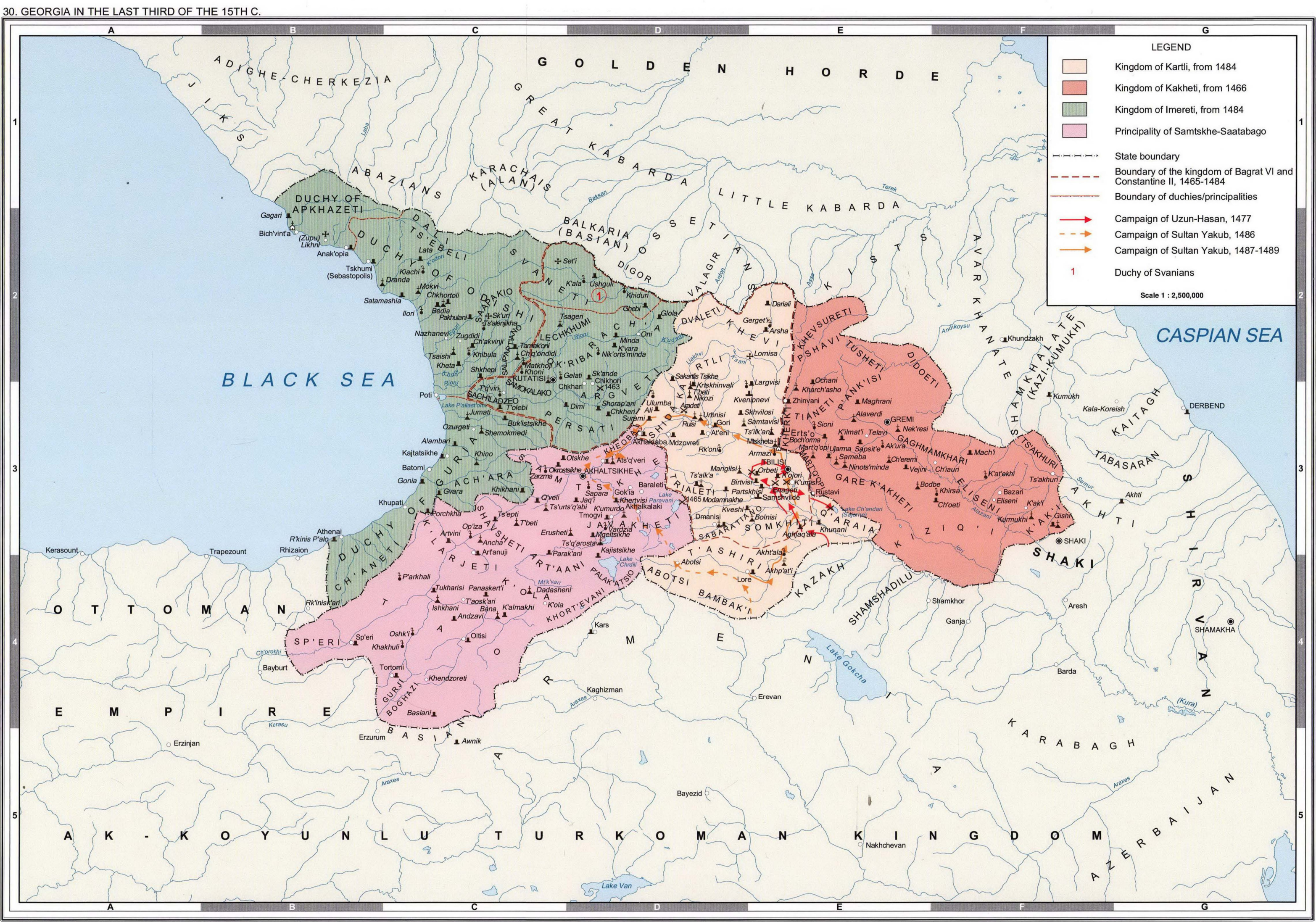
GEORGIA IN THE LAST THIRD OF THE 15TH C.png
 
Last edited:
  • 2Like
  • 2
Reactions:
Fair. For what it's worth the present setup also doesn't really represent any other arbitrary carving-up of Georgia at this time. I think the Duchy of Tao was only included because it felt odd to have Georgia have a subject (Samtskhe) that cuts it off from Tao.
 
  • 1Like
Reactions:
Georgian feudalism is very complex and to this day is not fully understood, but most scholars agree that it was less like the typical western European Frankish-derived system and was more in line with the bureaucratic form of government present in Byzantium.

Unlike the "barbarian kingdoms" of western Europe, there was actual state and dynastic continuity between the kingdom of Iberia, kingdom of the Iberians, and the kingdom of Georgia. There was no real concept of statehood for the appointed fiefdoms in the kingdom, even during and after the split of the kingdom under the Mongols (1259-1330).

The thing with the vassals of the Georgian crown that not a lot of people seem to realise is that the monarch benefited from the strengthening of their subjects.

According to the historian James Baillie in Bret Devereaux's blog:

"This wasn’t something I expected to find, at least in this form. One of my starting points was to look at regional rulers (eristavis) and evidence for decentralisation and local/regionalist sentiment within Georgia: but there’s actually little evidence that this was a motivating political factor. On the contrary, Georgia’s elite culture seems to have been quite centralised on the court. This was not because the state had effectively centralised its infrastructure and brought the nobility under its heel into serving the state, though: Georgian monarchs seem to have often aimed to increase, not decrease, the power of their vassals, on the grounds that this reflected significantly greater prestige onto them".

TL;DR - Georgian vassals were basically administrative divisions until the mid-15th century; state collapse was due to the rise of collegial sovereignty; sovereignty was reserved for royalty after the early 11th century.

2560px-Duchies_of_Kingdom_of_Georgia%2C_XIII_c.svg.png
View attachment 1259913
So, essentially, Georgia should be one, single, big tag?
 
  • 1
Reactions:
So, essentially, Georgia should be one, single, big tag?


Atleast the core part of Georgia. Samstkhe and Tao are outliers, Alastani is a royal principality, while the Armenians and Shaki are just recently added to the fold after the collapse of the Ilkhanate one year ago in-game.


  • 3Like
Reactions: