• We have updated our Community Code of Conduct. Please read through the new rules for the forum that are an integral part of Paradox Interactive’s User Agreement.

Tinto Maps #18 - 13th of September 2024 - Persia & Caucasus

Hello everyone, and welcome to one more Tinto Maps! Today we will be taking a look at Persia and the Caucasus! These are regions that encompass several modern-day countries and regions (Iraq, Iran, Balochistan, Afghanistan, Transoxiana, etc.), but for the sake of simplicity, we decided to name this DD this. Let’s start, without further ado!

Countries:
Countries.png

Colored Wastelands.png

The region is quite interesting in 1337, as there are plenty of countries to play with. The Ilkhanate is still alive, but in name only, the real power being hosted by the Jalayirids, who are overlords of some of their neighbors (the Chobanids, and the Eretnids). Other countries, such as Gurgan, the Kartids, and Muzaffarids are also struggling to get the hegemony over the region. Meanwhile, the strongest power in the Caucasus is the Kingdom of Georgia, although the region is also quite fragmented among different polities.

Ilkhanate.png

And speaking of the Ilkhanate, you may have wondered why isn’t it a unified tag… Well, it’s because we consider that it is clearly in decadence, having lost any grasp of authority over the provinces, so the best way of portraying it is through an International Organization. What we can see in this mapmode is that there are two pretenders to get the power, the Jalayarids and Gurgan, with the other countries still being formally part of it. I won’t talk more today about how it works and its features, but I’ll just say that there are two clear fates for the Ilkhanate: being dissolved, as historically happened, or being restored in full power as a unified country.

Dynasties:
Dynasties.png

Not much to say today about the dynasties, as they’re akin to the country names, in most cases. Well, you might wonder which one is the yellow one, ruling over Gurgan… That country is ruled by the Borgijin, heirs of Genghis Khan. Now you get the full picture of their rule over the Ilkhanate being challenged by the Jalayirids, I think…

Locations:
Locations.png

Location 2.png

Locations 3.png

Locations 4.png

Locations 5.png


Provinces:
Provinces.png


Areas:
Areas.png


Terrain:
Climate.png

Topography.png

Vegetation.png

We’re back to a region with lots of different climates, topography, and vegetation. This will make it very unique, gameplay and looking-wise.

Harbors:
Harbor.png

You might notice that there are ports in the Caspian Sea… Because, well, it’s considered a sea in our game, so there can be ships and navies over it.

Cultures:
Cultures.png

There's quite a lot of cultural division throughout the region... The Caucasus is, well, the Caucasus, divided among lots of different people. Then we have the Iraqi and Kurdish in Iraq, Persian and a number of other cultures in Iran, Baloch in Balochistan, Afghan in Afghanistan, and Khorasani, Turkmen, Khorezm, Hazara, and Tajiks, among others, in Khorasan and Transoxiana.

Religions:
Religion.png

Another interesting religious situation. Orthodox is the main religion in Georgia, and Miaphysitism in Armenia, with other confessions spread here and there throughout the Caucasus (Khabzeism, and three 'Pagan' confessions, Karachay-Balkar, Vainakh, and Lezgin). Then Iraq is divided among Sunni, to the north, and Shiism, to the south. And Iran is in an interesting situation, having a Sunni majority, but with some important Shiite pockets here and there. And Zoroastrianism, of course. It was not trivial to properly portray them, as we don't have good data for the 14th century. So what we did was some calculations, between sources that tell that there was still a majority as late as the 11th century, and the religion becoming severely reduced by the 16th century. Therefore, we decided to go with 20% of the population as a general rule of thumb; however, we're quite open to feedback over this matter.

Raw Materials:
Raw Materials.png

This region is full of rich resources, in stark contrast to the one we showed last week, Arabia. There are a couple of bugs on this mapmode that you might spot, I think.

Markets:
Markets.png

This region has several markets: Tabriz, Baghdad, Esfahan, Hormuz, Nishapur, and Zaranj., This will make for regionally fragmented-but-integrated economies (that is, good market access everyhwere, but with regionally diverging economies).

Population:
Population.png

Population 2.png

Population 3.png

Population 4.png

Population 5.png

The total population of the region is around 9M, taking into account all the different areas that we’re showing today. That is divided into about 4.5M in Iran, 2M in Iraq, 1.5M in the Caucasus, and around 1.5M in Transoxiana.

And that’s all for today! Next Friday we will be taking a look at India! Yes, in its entirety; we think that it is the best way to do it, although we’ll talk more about it next week. Another change, only for next week: the DD will be published at 10:00 instead of the regular 15:00, as I won’t be available in the afternoon to reply. Letting you know so there’s a proper wow-pole-run, yes. See you!
 

Attachments

  • Cultures.png
    Cultures.png
    3,1 MB · Views: 0
  • Religion.png
    Religion.png
    3,2 MB · Views: 0
  • 86Love
  • 84Like
  • 5
  • 3
  • 1Haha
  • 1
Reactions:
Diplomacy of Georgia
In this post I'll discuss the diplomatic relations of the Kingdom of Georgia with its allies, enemies, and noteworthy vassals.

Georgia became especially diplomatically renowned under Giorgi V, the incumbent king in 1337, who largely bloodlessly united eastern, western, and southern Georgia, first as a Mongol subject, and from 1335 onwards, as an independent ruler.
[1]

According to "History of Georgia in 4 volumes", Giorgi V had "political and diplomatic relations with both Eastern and Western countries: Byzantium, the Empire of Trebizond, France, the Pope of Rome, the Sultanate of Egypt, and others." [2]

Let's begin with allies...
Mamluk Sultanate

While there were earlier attempts by Georgia to improve relations with the Mamluk Sultanate, partly to use them against the Ilkhanate, and partly to restore the old privileges of Georgian pilgrims in Palestine, they didn't bear fruit. While David VIII did regain control over the Georgian Monastery of the Cross in Jerusalem in either 1305 or 1310, many churches still remained in Muslim hands, being converted into mosques over time, most notable of these being the Church of the Holy Sepulchre itself.

According to the book: "Giorgi V, from the very beginning of his reign, paid close attention to the Georgian monasteries of Jerusalem. He sent the first embassy to them (Mamluk Sultanate) in 1316 (when he was still considered the regent of Giorgi the Younger); and the second in 1320. King Giorgi sent expensive gifts and a letter to the Sultan of Egypt. Apparently, Giorgi asked for the return of the Georgian monasteries and the abolition of all the laws that were offensive to Christians, including the ban on Christian pilgrims sitting normally on horses (as both legs had to be on the same side). In return, Giorgi proposed to the Sultan mutual military assistance."

"
Pipa, the son of the Eristavi of Ksani, and the deacon Ioane Bandaisdze were sent as ambassadors. The Sultan of Egypt fulfilled the request of King Giorgi: they returned the relics of the tomb of Christ and abolished the insulting laws of riding horses for Christians. In addition, Georgian worshipers were exempted from paying tribute and allowed horsemen to “enter the city with hoisted banners.”
[3]

According to the accounts of Ibn Fadlallah al-Umari, the king carried an elaborate title in the Mamluk court: "A famous and illustrious ruler... just to his subjects, the best among Orthodox kings, Sultan of the Georgians, defender of the lands of Rome and Iran... glorifier of the Holy Places (Palestine-Jerusalem)... helper of the Pope of Rome, friend of Muslims, and a great friend of kings and sultans." [4]

In-game, I suggest the two countries start in an alliance, or at the very least a mutual defensive agreement.

Two characters, namely Pipa Kvenipneveli and Ioane Bandaisdze, should be created.

The Patriarchate of Georgia (Mtskheta) should own a church building in Jerusalem.


Kingdom of France / Papacy / Republic of Genoa

As I have already written at length, Georgia had important ties with Latin Christendom at the time. For the sake of not repeating myself, I'll quickly summarise my propositions:

Genoa:

The Gazaria (vassal of Genoa) should have a Building Based Country called the Consulate of Savastopoli owning several locations in coastal western Georgia. Perhaps both sides can benefit from greater diplomatic ranges (as seen in Ludovico da Bologna's travels in the 1460s).

France:

Georgia and France should have a small "sent gift" modifier towards each other (embassy of 1332-33).

Papacy:

Georgia (as AI) should have greater likelihood to join Papal-sanctioned Crusades, if such mechanics exist for Orthodox nations.


Kingdom of Cilicia


Georgia and Cilicia should start with a royal marriage. It is known that the daughter of Giorgi V, Soldane, married the brother of the king Constantine II, John of Poitiers-Lusignan, with whom she had a son, the future king Leo V.

While we don't yet know in detail how royal marriages work, I suspect a marriage between a close relative of the reigning monarch (in 1337 Leo IV) should count as a royal marriage.


Empire of Trebizond

King Giorgi pursued a careful policy of slow subjugation in Trebizond. If the state was once considered to be a Georgian fiefdom [5], during the 100 years of Mongol domination in Georgia, the empire slowly gained further political and military independence.

The king was known for interfering in Trebizond's internal politics, as the nation was divided between the pro-Georgian and pro-Constantinopolitan parties. For instance, In 1341, he supported Anna Anachoutlou's rebellion and placed her on the Trapezuntite throne.

As I've already written, Samstkhe should also have control of eastern Lazica. While we don't know the exact nature of the transfer of territory, it is known that the land was back under Trapezuntine control in the 1340s.

In summary, I believe Trebizond and Georgia (incl. Samtskhe) should start with a truce.


Jalayirid Sultanate

I believe Georgia should have the supposedly powerful cores on Jalayirid territory in the province of Arran.

According to David Muskhelishvili in the "Historical Atlas of Georgia": "In the extreme southeast the provinces of Shamkor and Gardman were lost. Qazvini describes the fortress-city of Khunani/Khanan as the extreme outpost of the country bordering Arran (Nuzhat: 94)."
[6]

true.png


As the territory had been directly incorporated into the kingdom since the early 12th century, was majority Armenian and Christian, I see no reason to make this land anything but a core of Georgia. If 2 locations as cores are too powerful, a simple claim may also suffice.


Hülegüids
(Ilkhanate rump state)


As Georgia had already been on the periphery of the empire even before its collapse in 1335, which can be seen in that it didn't pay tax since 1330. [7]

I think a long truce between the legitimate heirs of the Ilkhanate and Georgia should make sense.

Giorgi V rather diplomatically avoided conflict with the successor states of the empire, and succeeded in keeping the peace within his domain.

And now onto the vassals...


North Caucasus
(Tribal fiefdoms)

It is known that Giorgi V expelled the raiding Ossetians from Kartli in the earlier period of his reign, and not only expelled them, but instead forced them to pay tribute. On another separate occasion, he mustered an army and invaded the rest of the neighbouring tribes, which had been straying farther from the Georgian orbit, and once again asserted Georgian influence over the traditional subjects of the kingdom before the Mongol invasion. [7]

trur.png


That's all.


Sources used:

1. ასათიანი ნოდარ, et al. საქართველოს ისტორია : 4 ტომად : ტომი III. Edited by ლორთქიფანიძე მარიამ, Tbilisi, პალიტრა L, 2012, pp. 78–79, dspace.nplg.gov.ge/handle/1234/71580.

2. Ibid. p. 85.

3. Ibid. p. 86.

4. მეტრეველი ელენე. მასალები იერუსალიმის ქართული კოლონიის ისტორიისათვის XI-XVII Ს.ს. Tbilisi, 1962, pp. 43–44, dspace.nplg.gov.ge/handle/1234/406705.

5. Rayfield, Donald. Edge of Empires. Reaktion Books, 15 Feb. 2013, p. 145.

6. Muskhelishvili, David. Historical Atlas of Georgia. Translated by Lado Mirianashvili, edited by Devi Berdzenishvili and Guliko Liparteliani, Tbilisi, Artanuji, 2023, p. XII.

7. Rayfield, Donald. Edge of Empires. p. 140.
 
Last edited:
  • 7Like
  • 5
  • 2Love
Reactions:
As an addendum to yesterday's post, I'd like to write a few miscellaneous suggestions.


Localisations:

Georgian names for government ranks are such:

Emperor - Mepet-mepe (King of Kings, the title of the Georgian monarch, though I'd imagine the country starts as a kingdom for balance);

King - Mepe;

Prince - Eristavi, the non-hereditary title up to the 14th century, Mtavari, the hereditary equivalent of Eristavi from the 15th century onwards, and Tavadi, local lords.

Below this rank the lands held by these people can't really be classified as countries for the purposes of Project Caesar.

Count - no real equivalent, only similar one is Monapire, designating a marcher lord, ie a Markgraf;

Castellan - Tsikhistavi;

Untitled nobility - Aznauri.

This is the full list of notable Georgian titles, court positions, and generally useful terminology for the game according to Alexander Mikaberidze's "Historical Dictionary of Georgia":


Amirbar - Constable.
Amkarebi - Guilds in feudal Georgia. Amkarebi were led by an amkarbashi (ostati or ustabashi), who were usually elected by members and ratified by royal officials. Heads of the largest guilds were appointed by the king.
Atabeg - Chief tutor and guardian to the royal offspring, second high office of the court. After the 13th century, atabegs also ruled Samtskhe region.
Azat - Former serf freed by his lord.
Aznauri - Feudal lord in 5th—12th-century Georgia; lower order of the feudal nobility in the 12th—18th centuries.
Batoni - Lord, feudal baron.
Batonishvili - Son of a lord, usually the title of a prince of the royalblood.
Baziert-ukhutsesi - Master of the falconers, master of the royal hunt.
Begara - Peasant labor obligation.
Bogano - Landless peasant.
Bokault-ukhutsesi - Chief police constable or official in charge of security at the court.
Darbazi - Palace, hall; consultative body at the royal court.
Dedopali - Queen regnant or queen consort.
Didebulni - Noble, higher order of feudal aristocracy in Georgia in the11th—12th centuries.
Ejibni - Chamberlain.
Eri - Nation; in ancient Georgia, freemen.
Eshikaghabashi - Chief of the police and administrative apparatus in late feudal Georgia.
Exarch - A bishop, second highest position after a patriarch. In 1819, the Russian authorities appointed exarch to govern the Georgian church.
Ezomodzghvari - Controller of the royal household.
Ganmeget-ukhutsesi - Lord Steward.
Glekhi - Peasant.
Gziri - Chief of police.
Khevisberi - Ruler of a khevi, secular and ecclesiastical head among mountain-tribes of eastern Georgia.
Khevisuphali - Head of the valley, usually subordinated to eristavis.
Khizani - Peasant forced out from the lands of his lord and renting land from another lord.
Mamuli - Land granted in hereditary tenure. In a general sense, motherland.
Mandaturt-ukhutsesi - Chief overseer of the court, in charge of the palace guard and matters of protocol.
Mdabioni - Lower strata of the population.
Mdivanbegi - Chief Justice.
Meabjret-ukhutsesi - Master armorer.
Mechurchlet-ukhutsesi - Royal treasurer.
Meghvinet-ukhutsesi - Master of the royal wine cellar.
Mejamet-ukhutsesi - Chief butler of the royal household.
Melik (or malik) - Arab term for ruler or high official; the term was often used with respect to Armenian officials in charge of cities, i.e., mayor of Tbilisi.
Meremet-ukhutsesi - Master of the horse.
Mestumret-ukhutsesi - Master of ceremonies.
Mojalabe - Indentured peasant without land.
Mona-spa - Royal guard.
Mouravi - Royal official in charge of a region.
Msakhuri - Domestic servant or a serf raised to vassal gentry.
Msakhurt-ukhutsesi - Chief chamberlain, in charge of royal property, buildings, court ceremonies and receptions.
Mtsignobart-ukhutsesi - Chief secretary of the king; in 1104, the office was merged with that of Archbishop of Chqondideli to create the first office of the court.
Mtavari - Dynastic prince.
Namestnik - Viceroy of the Russian Emperors in the Caucasus.
Patroni - Proprietor, master or lord.
Qma - Serf; vassal.
Sadrosho - Military-administrative unit that provided specified number of men for the royal army.
Saeristavo - Territory under control of eristavi.
Sakhaso - Demesne, lands directly held by the king.
Sakhlitukhutsesi - Majordomo.
Samtavro - Literally territory ruled by mtavari, landed estate.
Satavado - Territory ruled by tavadi.
Satavistavo - Lands held by individual nobles.
Sauplistsulo - Appanage; royal or legislative land grant.
Sepetsulni - Royal children.
Shetsiruli qma - Clerical serf given by the king or lord to the church.
Spasalari - Commander-in-chief.
Tavadi - Prince; initially heads of noble families, later a separate class of nobility.
Tskalobis qma - A serf given by one lord to another or granted by the king to a lord.
Ukhutsesi - Elders.

I've not yet written of the flavour that should definitely be in the game in the form of Georgian court positions, their powers, the council and so on.


Religion:

A good name for the Georgian paganism which I've suggested would be "Kerptaqvanismtsemloba" - "კერპთაყვანისმცემლობა", lit. idol worship.

And this is the updated version of the religious-demographic map I made previously, which takes into account the rather sizable amount of conversions in northern Armenia under the Chalcedonian-Orthodox Zakarids since the late 13th century.


updewd9soc.png


Gold: Orthodoxy
Pink: Apostolic/Oriental Orthodoxy
Green: Sunni Islam
Blue: Kerptaqvanismtsemloba (Kartvelian Paganism)
Red: Apsua/Abkhaz Paganism

Regarding the Jews of the region, I've attached a helpful document about the Georgian Jews, which may help you model them in-game. I personally suggest against making a specific culture for them, as they have never regarded themselves as a different people from their fellow Christian Georgians.


Releasables:

Assuming there is a "Georgian Collapse" disaster, like in EU4, some vassal states should pop out of Georgia if the global crown power is low enough, or something of the sorts. Note that "Saeristavo" designates a state/administrative division which is often non-hereditary, while a "Samtavro" is hereditary. So, if the player releases these nations while their crown power is high enough (and thus not in a disaster), they should start as non-hereditary states.


2560px-Kingdom_of_Georgia_after_dissolution_as_a_unified_state%2C_1490_AD.svg.png


Areas and Provinces:

I think the Area of Georgia needs some changes.

As we've demonstrated in our numerous posts, Tao-Klarjeti and Somkhiti very much belonged to the Georgian political sphere.

Therefore, I think a change to the Area to something like this would be more appropriate.

If, however, such a change makes the Area too large, it can also be split in two, to reflect its past state as a divided nation during Mongol rule.

In that case, I suggest naming western and eastern Georgia Likht-Imereti (lit. that side of the Likhi) and Likht-Amereti (this side of the Likhi), respectively.

Armenia and the Armenian highlands definitely need some changes too.

trepidation.png


As @ Georgian Noble already made a map of the Provinces as they ought to be, I'll simply repost it here.

Location%202.png


Somes notes I have:

Regarding Abkhazia - it should extend farther into Tuapse as the location of Nicopsis is purported to be near the modern site of Novomikhaylovsky, slightly north of Tuapse.

I believe Poti should be a part of Mingrelia/Odishi.

And Tashiri should be called Somkhiti in the Georgian localisation.

In addition, I think it'd be great if some new locations (like Didoya) were added in the Caucasus mountains. While they were under "direct" control of the Georgian crown, the area had in fact next to no control from the capital. The localities were controlled by Khevisberis, but I don't think they merit full nationhood for the purposes of the game.


true.png


Royal forests:

It is known that the royal forests of Mukhrani enjoyed some privileges similar to its English contemporaries. Hence, I think a location in or around this area could serve as a royal forest in-game well.


Trade and Markets:

I think Tbilisi (or, rather, Tiflis, as it was known then) should be the centre of a market. As I've proven in my posts, Tbilisi was quite populous at the time, that is, until Timur's conquests. In Pope John XXII's words, in Giorgi V's time, Tbilisi was "a very important, populous, just and rich city".

I think it should have control over much of the south Caucasus region, along with eastern Armenia and parts of the north Caucasus.

It'd certainly make more sense than the current system of Trebizond having a miniscule amount of control over most of its territory, and would be further in line with the devs' policy of "regionally fragmented-but-integrated economies (that is, good market access everyhwere, but with regionally diverging economies)."

utter truth.png


Languages:
(inspired by @matfer13)

In the time frame of the game, Mingrelian and Laz would still be completely mutually intelligible. So, when modelling the Kartvelian languages, I suggest making 3 languages for the 4 cultures - Georgian language for the Georgian culture, Svan language for the Svan culture, and Zan for Mingrelian and Laz cultures.

Also, it'd be much better if the colours for the Kartvelian cultures were shades of one colour (like in CK3), preferably red.

Area-of-zan-languages.png
mern.png
 

Attachments

  • Страницы истории и культуры евреев Грузии - Членов М.pdf
    42,8 MB · Views: 0
Last edited:
  • 5
  • 3Like
  • 1Love
Reactions:
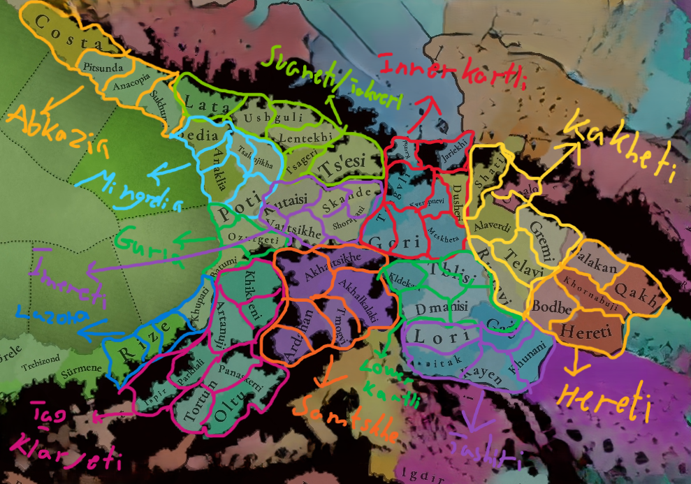
I dumped this whole history on you, to state why I think that Ushguli location should be divided into two - Latali and Ushguli. Latali would be where 'Dadishkeliani Svaneti" was located, while Ushguli where "Free Svaneti" was.
Firstly, fantastic post which was very detailed and also enjoyble to read, but i would like to point out that commune of Latali is the first commune of the free Svaneti from Bal gorge and guarded it from from the lower Bal Svaneti, or "Dadeshkeliani Svaneti", last commune before Bal gorge is Becho which also served as the seat for Dadeshekleianis and was an administrative center of Svaneti before Mestia, so i guess instead of Latali more appropirate name for the lower Bal region would be Becho, anyways as i said very good post, keep up my former Lechkhumian mukhbe and now dzmao DD
 
  • 3Like
  • 2Love
Reactions:


I think this is the final iteration of the Persia region + peripheries map, unless anything crazy pops up:
  • Adjusted borders:
  • New tags:
    • Principality of Hytuk - ruled by the Hytuk/Ghetik
    • Principality of Copa - ruled by the ?
    • Principality of Sobay/Hatukay - ruled by the Hatukay
    • Principality of Kipike - ruled by the Chupako
    • Principality of Kremuk/Temirgoy - ruled by the Temirgoy
    • Principality of Kabardia - ruled by the Kabardians
    • Principality of Digor - ruled by the Acharkatag
    • Saeristavo of Ksani - ruled by the Bibiluri/Kvenipneveli
    • Emirate of the Usfurids - ruled by the Usfurids
  • Naming suggestions:
    • Sufids to Khwarazm
    • Injuids to Fars
    • Muzaffarids to Yazd
    • Mihrabanids to Sistan
    • Lower Khachen to Khachen
    • Upper Khachen to Tsar
      • Is a vassal of Khachen


View attachment 1264058

Locations:

View attachment 1264059


As a final addition to the map have you considered adding the Sayin Khan confederacy in the Mangyshak peninsula that Aramenian mentioned a while back

 
  • 1
Reactions:
I also wonder whether the Golden Horde had control over the Turkmen tribes inhabiting the Mangyshlak Peninsula in 1337.
Because it seems that these tribes have created their own tribal confederation here, which is ruled by Ersari baba.
The border of the influence of the Nogai culture should be the Emba River

I wonder why this area is a desert without cities as it is clearly visible on old maps that there were settlements here, most of these settlements no longer exist or have different names.

View attachment 1198880
1913
View attachment 1198875


New tag:
  • Sayin Khan Confederacy - ruled by Ärsary Baba / OR his son, Eynel Ghazi, of the Ärsary tribe
    • Maybe have Ärsary Baba as a very old ruler, with three sons ready for a nice succession war + their kids
Below is a possible family tree:

1741869260134.png


New locations:


Countries COMBO NEWfffff.png
Locations NEWffff.png


Last edited:
  • 3Like
  • 3
  • 1Love
Reactions:


New tag:
  • Sayin Khan Confederacy - ruled by Ärsary Baba / OR his son, Eynel Ghazi, of the Ärsary tribe
    • Maybe have Ärsary Baba as a very old ruler, with three sons ready for a nice succession war + their kids
Below is a possible family tree:

View attachment 1265036

New locations:


View attachment 1265082View attachment 1265083


I wrote about potential new locations here in the Persia map thread (edit: oh hey this is also the Persia map thread, lol), without any political info. I don’t know if it’s 100% clear when exactly Ersari Baba lived or founded the confederation but I think it’s a generally good idea as a way of representing the people we know were there but seemingly not closely tied to other kingdoms, though I didn’t do close political research to really say for sure. In later centuries those people would at times pay tribute to surrounding rulers and at times be raiders or pirates annoying those rulers.

You could connect the southern areas where I drew locations to the Mangyshlak area as well but naming becomes a problem.

I’d be wary of trying to draw anything detailed like the course of the Uzboy from most early European maps, which are a mix of quite correct things, things you can’t find mentioned anywhere else, and wildly misplaced things (see “Menkislak” on the map you posted, which is part of a trend of thinking the first Western European to describe Mangyshlak (Jenkinson) was totally wrong about the latitude (he wasn’t) and the cartographers putting it quite far south (it’s not)). And they are often clearly copying each other. They are useful sources but you have to be constantly skeptical while using them.

However the course (or a course, at least) of the Uzboy specifically is easily visible on any satellite map so that’s not a problem unless you want to deep-dive reconstructions of the medieval river (which I believe people have published on, but which I have not read in detail).
 
Last edited:
  • 2Like
Reactions:
I wrote about potential new locations here in the Persia map thread, without any political info. I don’t know if it’s 100% clear when exactly Ersari Baba lived or founded the confederation but I think it’s a generally good idea as a way of representing the people we know were there but seemingly not closely tied to other kingdoms, though I didn’t do close political research to really say for sure. In later centuries those people would at times pay tribute to surrounding rulers.

You could connect the southern areas where I drew locations to the Mangyshlak area as well but naming becomes a problem.

I’d be wary of trying to draw anything detailed like the course of the Uzboy from most early European maps, which are a mix of quite correct things, things you can’t find mentioned anywhere else, and wildly misplaced things (see “Menkislak” on the map you posted, which is part of a trend of thinking the first Western European to describe Mangyshlak (Jenkinson) was totally wrong about the latitude (he wasn’t) and the cartographers putting it quite far south (it’s not). They are useful sources but you have to be constantly skeptical while using them.

However the course (or a course, at least) of the Uzboy specifically is easily visible on any satellite map so that’s not a problem unless you want to deep-dive reconstructions of the medieval river (which I believe people have published on, but which I have not read in detail).
Would these people perhaps be better represented as a SoP than a tag?


I think this is the final iteration of the Persia region + peripheries map, unless anything crazy pops up:
  • Adjusted borders:
  • New tags:
    • Principality of Hytuk - ruled by the Hytuk/Ghetik
    • Principality of Copa - ruled by the ?
    • Principality of Sobay/Hatukay - ruled by the Hatukay
    • Principality of Kipike - ruled by the Chupako
    • Principality of Kremuk/Temirgoy - ruled by the Temirgoy
    • Principality of Kabardia - ruled by the Kabardians
    • Principality of Digor - ruled by the Acharkatag
    • Saeristavo of Ksani - ruled by the Bibiluri/Kvenipneveli
    • Emirate of the Usfurids - ruled by the Usfurids
    • Confederacy of Sayin Khan - ruled by Ärsary Baba of the Ärsary tribe
  • Naming suggestions:
    • Sufids to Khwarazm
    • Injuids to Fars
    • Muzaffarids to Yazd
    • Mihrabanids to Sistan
    • Lower Khachen to Khachen
    • Upper Khachen to Tsar
      • Is a vassal of Khachen


View attachment 1265085

Locations:

View attachment 1265087


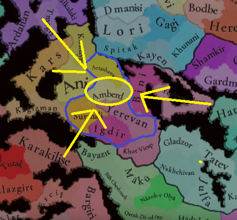
Amberd It is the capital of the Armenian principality of Amberd so the principality of Alastani should lose this location.
Amberd.png


New tag:
  • Sayin Khan Confederacy - ruled by Ärsary Baba / OR his son, Eynel Ghazi, of the Ärsary tribe
    • Maybe have Ärsary Baba as a very old ruler, with three sons ready for a nice succession war + their kids
Below is a possible family tree:

View attachment 1265036

New locations:


View attachment 1265082View attachment 1265083


As for the Sayin Khan Confederacy, I was wrong, this confederation was probably founded after Timur's invasion of the Golden Horde

In 1337, Mangyshlak was probably under the control of Tokhtamysh grandfather.

Zrzut ekranu 2025-03-13 164328.png
 
  • 2
  • 1
Reactions:
Amberd It is the capital of the Armenian principality of Amberd so the principality of Alastani should lose this location.
View attachment 1265161

As for the Sayin Khan Confederacy, I was wrong, this confederation was probably founded after Timur's invasion of the Golden Horde

In 1337, Mangyshlak was probably under the control of Tokhtamysh grandfather.

View attachment 1265167


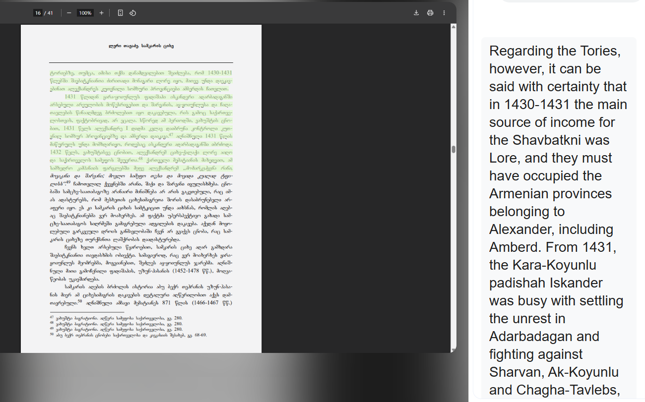
I am inclined to believe that Amberd held Amberd as well. But besides a mention on English wiki of the current ruler restoring the castle, there was no reference to a source for said mention, while @GenericUsername1444 apparently has a source where Alastani held Amberd in early 1300s.

These are two conflicting narratives, but the Georgian source is the only one I know of currently, though I haven't read it myself, as it is in Georgian. Maybe @GenericUsername1444 could provide the passage which concerns Amberd.


Last edited:
  • 2Like
Reactions:
Would these people perhaps be better represented as a SoP than a tag?
They don't seem uniquely different from many of the other groups in the region, which the devs seem to be avoiding using SOPs for (e.g Arabian tribes or the nomads in Turkey would share a lot of the same characteristics)
 
  • 1Like
Reactions:
Would these people perhaps be better represented as a SoP than a tag?
As I said I didn’t do deep research on the political situation (was more focused on filling wastelands) but I think it’s very possible. There was never any mention I saw in discussions of Khwarazm or Persia of any sort of organized state in this area, and a few centuries later when Abulghazi is describing how he conquered/extracted tribute from them it very much sounds like a collection of tribes that may or may not even work together all that well (some of this is quoted in my original post). Additionally he talks of his “conquest” in terms of oaths of allegiance and levying of tribute in goods from clearly autonomous tribes, not in terms of land control or the destruction of a government.

However I really didn’t read into the political history of Ersari Baba and his confederation whatsoever, or the political details of the Mongol era much at all, plus the dates are unclear, so there’s definitely a lot of space for further information here.

It’s possible Ersari forged them into something that really was a state, and we match the timeline to 1337; it’s also possible we say it’s pre-Ersari and they don’t even form a unified SoP. I’ll leave that research to someone else.

This is not particularly rich land boxed in by landed kingdoms ruling notably richer land, so not a ton of attention is given to the area in most sources.

Also I was not looking at Mangyshlak at all and I know that might have a bit of a different history than the southern Bay of Balkan area; my comments here only apply to the south and not to Mangyshlak.
 
Last edited:
I found the source regarding Alastani's borders in the book "Historical Atlas of Georgia", from which we've drawn a lot of reliable information from, and as such I see no reason to distrust the presented fact that Amberd was indeed held by the Alastaneli Bagrationis. But let's take a look at the sources anyway.

The aforementioned book describes the situation in mid-14th century Georgia as such:

"As we learn from the documentary and narrative sources, the junior branch of the Bagrat'ionis (the offspring of Giorgi the Brilliant's brother) ruled in Zemo Javakheti and parts of Kvemo Kartli (with the center in Lore) and northern Armenia. They are titled Alast'aneli, i.e. of Alast'ani after the homonymous village in Javakheti. This dynasty lasted for almost a hundred years. The last Alast'aneli died in the 1380s and some of their holdings (including Alast'ani) passed to the Church. In modern literature the Alast'anelis are referred to as provincial kings (Ninidze 1995)."

Let's read Ninidze '95. The English title of the book is "Provincial Kings in Georgia from the 14th to 15th Centuries". Here's the link to the Parliamentary library entry. And here's their updated version of the paper with an English synopsis (the attached file):

"The purpose of the proposed article is to study the chapel inscription of Hovhannavank Monastery. Taking into account the facts of the inscription itself, we have its exact date-1320/21. Collating the data of the given inscription with the Georgian historical sources of the same period showed that the owners of this Armenian land, i. e, Hovhannavank, are the Georgian king David VIII/1293-1311/ and his family (elder son Melkisedek, his wife, Queen Tamar and their young son Giorgi). All these materials extend our knowledge of collateral line of the Georgian Royal House of "Alastan kings", as well as of their estates. Hence it appears that, besides Javakheti and Kvemo Kartli (Southern Georgia), some of the part of historical Armenia belonged to them.

Thus, together with the other facts, this inscription also shows that, during the rule of Mongols, the Northern Armenia represented an integral part of the Georgian kingdom."


I don't think it gets more explicit than that. The map made by Davit Muskhelishvili is accurate for the time frame of 1337.
 

Attachments

  • პროვინციის მეფეთა ისტორიის ზოგიერთი საკითხი.pdf
    7,6 MB · Views: 0
  • 2
  • 1
Reactions:
As for the Sayin Khan Confederacy, I was wrong, this confederation was probably founded after Timur's invasion of the Golden Horde

In 1337, Mangyshlak was probably under the control of Tokhtamysh grandfather.


Honestly, I wouldn't discount the confederacy on that basis. It could simply be that they were subject to Qutluq-Khwaja.


I found the source regarding Alastani's borders in the book "Historical Atlas of Georgia", from which we've drawn a lot of reliable information from, and as such I see no reason to distrust the presented fact that Amberd was indeed held by the Alastaneli Bagrationis. But let's take a look at the sources anyway.

The aforementioned book describes the situation in mid-14th century Georgia as such:

"As we learn from the documentary and narrative sources, the junior branch of the Bagrat'ionis (the offspring of Giorgi the Brilliant's brother) ruled in Zemo Javakheti and parts of Kvemo Kartli (with the center in Lore) and northern Armenia. They are titled Alast'aneli, i.e. of Alast'ani after the homonymous village in Javakheti. This dynasty lasted for almost a hundred years. The last Alast'aneli died in the 1380s and some of their holdings (including Alast'ani) passed to the Church. In modern literature the Alast'anelis are referred to as provincial kings (Ninidze 1995)."

Let's read Ninidze '95. The English title of the book is "Provincial Kings in Georgia from the 14th to 15th Centuries". Here's the link to the Parliamentary library entry. And here's their updated version of the paper with an English synopsis (the attached file):

"The purpose of the proposed article is to study the chapel inscription of Hovhannavank Monastery. Taking into account the facts of the inscription itself, we have its exact date-1320/21. Collating the data of the given inscription with the Georgian historical sources of the same period showed that the owners of this Armenian land, i. e, Hovhannavank, are the Georgian king David VIII/1293-1311/ and his family (elder son Melkisedek, his wife, Queen Tamar and their young son Giorgi). All these materials extend our knowledge of collateral line of the Georgian Royal House of "Alastan kings", as well as of their estates. Hence it appears that, besides Javakheti and Kvemo Kartli (Southern Georgia), some of the part of historical Armenia belonged to them.

Thus, together with the other facts, this inscription also shows that, during the rule of Mongols, the Northern Armenia represented an integral part of the Georgian kingdom."


I don't think it gets more explicit than that. The map made by Davit Muskhelishvili is accurate for the time frame of 1337.
This source does not mention anything about the Amberd fortress, only that this dynasty controlled northern Armenia.
I think this is a reference to the Somkhiti region.


Zrzut ekranu 2025-03-13 175232.png

Perhaps after the fall of the Armenian Vakhutians dynasty this land was taken over by the Georgians(Alastani) because they had control over this fortress at a later time.

Zrzut ekranu 2025-03-13 173231.png

 
Last edited:
  • 1
  • 1
Reactions:
This source does not mention anything about the Amberd fortress
Amberd fortress and Hovhannavank belong to the same region and are geographically rather close. It's not exactly a huge leap of reasoning from the researchers' end to assume that their ownership of this church, and all the land around it includes Amberd fortress.

bro.png


I think this is a reference to the Somkhiti region.
But what do I know, do as you see fit.
Those are confusing terms, I agree, and it seems like Google Translate isn't exactly doing its job well here, but I don't quite understand why you're quoting an entirely unrelated paper regarding the reign of Alexander I "The Great"?

His reign takes place in the mid-15th century, more than 70 years after the disestablishment of the Principality.


Either way, this is the chronology of land ownership around Amberd:

The first Alastaneli prince (future Giorgi IV) is given this land before his ascension to the throne, as an equivalent of the western Dauphin or the Prince of Wales.

After the Mongol conquest, this land is given to the junior branch of the Bagratid dynasty.

The Alastaneli dynasty dies out, and some land is given back to the church, while most of it is returned to the king.

Much of Armenia is conquered by Timur, and later reconquered by Alexander I (see attachment).
 

Attachments

  • GEORGIA IN THE 10-60S OF THE 15TH C. (real).png
    15,3 MB · Views: 0


Can you read Armenian @Aramenian?

If you can, you could try and see books:

Վաչուտյաններ, Ե., 2001

Վաչուտյաններ, Ե., 2023

I couldn't get a hold of them. For some reason the Pan-Armenian Digital Library triggers my Windows Security :p


Can you read Armenian @Aramenian?

If you can, you could try and see books:

Վաչուտյաններ, Ե., 2001

Վաչուտյաններ, Ե., 2023

I couldn't get a hold of them. For some reason the Pan-Armenian Digital Library triggers my Windows Security :p


Unfortunately I can't read Armenian, I use google translator


Zrzut ekranu 2025-03-13 185752.png

the same thing happens to me.


Can you read Armenian @Aramenian?

If you can, you could try and see books:

Վաչուտյաններ, Ե., 2001

Վաչուտյաններ, Ե., 2023

I couldn't get a hold of them. For some reason the Pan-Armenian Digital Library triggers my Windows Security :p


I got access to them, most of it is about boring tax income and church details and Amberd is mentioned two (2) times

Screenshot_20250313-182522~2.png
Screenshot_20250313-185516.png
There seems to be a print error on this one, so no clue who "Bogyots" refers to, possibly Bagrationi. Also the automatic translation on the right doesn't seem entirely accurate, separating out the quote gives this:
Screenshot_20250313-192639.png


Screenshot_20250313-183909~2.png
Screenshot_20250313-185554.png


There weren't really any releveant details about the 1300s
 
  • 3
  • 1Like
Reactions: